![]()
![]()
3.0 Description of the County
3.1 Demographics, location, topography, and climatic data
Churchill County is located in the western portion of central Nevada, with an approximate land area of 3,145,000 acres. Land management acreage in Churchill County is summarized in Table 3-1 and illustrated in Figure 3-1.
| Land Administrator | Acreage |
|---|---|
| BLM | 2,059,268 |
| FWS | 163,021 |
| Dept. of Defense | 240,792 |
| BIA | 42,880 |
| State of NV | 103,812 |
| Private | 482,212 |
| Other | 52,335 |
| Source: BLM land ownership GIS database. | |
The Nevada State Demographer website listed 25,808 people in Churchill County, and 8,301 people in the incorporated City of Fallon in 2003. Major employers in the county are those in the service, government, and trade sectors, including the Fallon Naval Air Station and the Nevada Commission on Economic Development website.
Elevation within the county ranges from 3,963 feet at Fallon, to 9,966 feet at Mt. Augusta in the Clan Alpine Mountains. The Carson Sink is a swampy 100-square mile area, part of a larger playa covering over 1,000 square miles in Churchill County. The sink, a remnant of Pleistocene Lake Lahontan, is the terminus of the Carson River. Rainfall in the county averages from four to seven inches, and temperatures can range from lows between thirty and forty degrees Fahrenheit during winter months to highs ranging between eighty and ninety degrees Fahrenheit in the summer (Western Regional Climate Center website).
3.2 Wildfire History
The fire history of Churchill County was researched through the Nevada BLM State office. There were 150 wildfire ignitions recorded in Churchill County between 1980 and 2003. Wildfire history within the County is detailed in Figure 3-2. Table 3-2 summarizes fire history and fire ignitions by year.
| Year | Number of Fire Ignitions (1) |
Total Fire Acreage (2)(3) |
|---|---|---|
| 1980 | 1 | NA |
| 1981 | 1 | 300 |
| 1982 | 0 | 0 |
| 1983 | 2 | 9 |
| 1984 | 6 | 1,705 |
| 1985 | 13 | 15,114 |
| 1986 | 11 | 510 |
| 1987 | 6 | 28 |
| 1988 | 6 | 4 |
| 1989 | 1 | 70 |
| 1990 | 1 | 3 |
| 1991 | 5 | 31 |
| 1992 | 7 | 1,170 |
| 1993 | 2 | 605 |
| 1994 | 3 | 312 |
| 1995 | 1 | 1 |
| 1996 | 16 | 13,977 |
| 1997 | 4 | 7,461 |
| 1998 | 3 | 171 |
| 1999 | 18 | 227,608 |
| 2000 | 9 | 67,271 (4) |
| 2001 | 14 | 1,736 (4) |
| 2002 | 12 | 3,013 (4) |
| 2003 | 8 | 1,263 (4) |
| TOTAL | 150 | 342,362 |
| (1) Fire ignitions provided by the National Interagency Fire Center (NIFC), Boise, Idaho as spatial data (point form)at). (2) Acreage is provided by the Nevada BLM spatial data when available, otherwise acreage is derived from the NIFC data. (3) Total Fire acreage is not specific to Churchill County. For some fires acreage could not be determined specifically within Churchill County. (4) Additional fire history information provided by the Fallon/Churchill VFD. |
||
3.2.1 Ignition Risk Factors
Ignition risks for wildfires fall into two categories: lightning and human caused. Human caused ignitions can come from a variety of sources: fires started along roads from burning material thrown out of vehicle windows or ignited during auto accidents, off-road vehicles, railroads, arcing power lines, agricultural fires, ditch burning, debris burning in piles or burn barrels, target shooting, unattended campfires, and fireworks. The ignition source records for Churchill County indicate that for 150 fire incidents, 103 were due to lightning, 34 were human caused, and thirteen were not recorded according to origin.
3.2.2 Effect of Cheatgrass on Fire Ecology
The science of fire ecology is the study of how fire contributes to plant community structure and species composition. A “fire regime” is defined in terms of the average number of years between fires under natural conditions (fire frequency), and fire severity, or the amount of dominant vegetation replacement. Natural fire regimes have been affected throughout most of Nevada by twentieth century fire suppression policies. Large areas that formerly burned with high frequency but low intensity (fires more amenable to control and suppression) are now characterized by large accumulations of unburned fuels, which once ignited, will burn at higher intensities.
Big sagebrush is the most common plant community in Nevada with an altered fire regime, now characterized by infrequent, high-intensity fires. Sagebrush requires ten to twenty or more years to reestablish on burned areas. During the interim these areas can provide the conditions for the establishment and spread of invasive species and in some cases inhibit sagebrush reestablishment. The most common invasive species to reoccupy burned areas in northern Nevada is cheatgrass (Bromus tectorum).
Cheatgrass growth is dependent on annual moisture. In years of normal precipitation, production is typically low to no growth; in years of higher than normal precipitation cheatgrass will produce at much higher rates. While it presents a variable hazard dependent on moisture and annual growth, it is considered a high hazard fuel type because it presents an extremely receptive fuel bed for ignitions that rapidly burn into adjacent vegetation. A fire spreading from a cheatgrass stand into adjacent, unburned, native vegetation creates additional disturbed areas vulnerable to cheatgrass invasion. Associated losses of natural resource values such as wildlife habitat, soil stability, and watershed functions may also occur.
Eliminating cheatgrass is an arduous task. Mowing defensible space and fuelbreak areas annually before seed set is effective in reducing cheatgrass growth. In areas with livestock, implementing early-season intensive grazing up to and during flowering may aid in depleting the seed bank. It may take years and intensive treatment efforts to fully eliminate cheatgrass in a given area, but it is necessary in order to revert the landscape to the natural fire cycle and reduce the occurrence of large, catastrophic wildfires. Community-wide efforts in cooperation with county, state, and federal agencies are vital to reducing the wildfire hazard from cheatgrass.
3.3 Natural Resources and Critical Features Potentially at Risk
Critical features at risk of loss during a wildfire event can be economic assets such as agricultural and industrial resources or cultural features such as historic structures, archaeological sites, and recreation-based resources.
3.3.1 Historical Registers
Two Historic Registers were researched for this report. There are eighteen sites listed on the National Register of Historic Places for Churchill County. The Nevada State Register of Historical Places lists ten sites. Historic districts, historic buildings, and resources that lie in the wildland-urban interface and could be negatively impacted by wildfire are summarized in Table 3-3.
| Site Name | Location | Source Register |
|---|---|---|
| Harmon School | NW corner of N. Harmon and Kirn Roads, Fallon | Nevada State Register of Historic Places |
| Hazen Store | 600 Reno Highway (U.S. Highway 50 Alt), Hazen | National Register of Historic Places |
3.3.2 Flora and Fauna
There are three federally listed threatened or endangered species with potential habitat in Churchill County; one is proposed for delisting. Four species are protected by Nevada state legislation and are identified in Table 3-4. One species is pending final decision on status. The Nevada Natural Heritage Program, the Nevada Division of Forestry, and the Nevada Department of Wildlife should be consulted regarding specific concerns and potential mitigation to minimize impacts to these species in the event of a catastrophic wildfire.
| Scientific name | Common name | Legislation |
|---|---|---|
| Plants | ||
| Opuntia pulchella | Sand cholla | Pending - NRS 527.060.120 |
| Fish | ||
| Oncorhynchus clarki henshawi | Lahontan cutthroat trout | Endangered Species Act - listed threatened; NRS 501 |
| Mammals | ||
| Brachylagus idahoensis | Pygmy rabbit | NRS 501 |
| Euderma maculatum | Spotted bat | NRS 501 |
| Lontra canadensis | River otter | NRS 501 |
| Birds | ||
| Charadrius alexandrinus nivosus | Western snowy plover | Endangered Species Act - listed threatened; NRS 501 |
| Haliaeetus leucocephalus | Bald eagle | Endangered Species Act - listed threatened, proposed delisting; NRS 501 |
The Stillwater National Wildlife Reserve Complex (NWRC) is located six miles northeast of Fallon and covers 163,021 contiguous acres of Federal land in three contiguous reserves managed by the U.S. Fish and Wildlife Service (USFWS): the 79,570-acre Stillwater National Wildlife Refuge (NWR), the 65,603-acre Stillwater Wildlife Management Area (WMA), and the 17,848-acre Fallon NWR. The varied habitat contained in this complex such as freshwater and brackish water marshes, alkali playas, salt desert shrublands, riverine riparian areas, a 25-mile long dunal complex, and a desert lake containing island habitats makes a substantial contribution to wildlife conservation. These habitats attract nearly 400 species of vertebrate wildlife (more than 260 bird species) and countless species of invertebrates. Well-known to birdwatchers and conservationists, the Stillwater WMA is listed as a “Globally Important Bird Area” by the American Bird Conservancy, and the reserve complex has been designated a site of international importance by the Western Hemispheric Shorebird Reserve Network due to the hundreds of thousands of shorebirds and waterfowl that abound during spring and fall migration.
The Humboldt Wildlife Management Area is located in both Churchill and Pershing Counties, approximately 35 miles north of Fallon, Nevada along U.S. Interstate 80. The Humboldt Wildlife Management Area includes alkali playas, salt desert shrublands, Toulon Lake, Humboldt Lake, and several other lakes and marshes. The approximate 38,700-acre complex is managed by the Nevada Division of Wildlife and also contains Bureau of Land Management lands. Tamarisk, a noxious weed, dominates large areas of the wildlife management area and sprouts vigorously after fire.
3.4 Previous Fuel Hazard Reduction Projects
There have been no fuel hazard reduction projects in Churchill County planned or realized during the last ten years.
Figure 3-1Community Locations and Land Ownership Churchill County, Nevada |
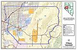 |
Figure 3-2Fire History, Ignition Risks, and Potentially At Risk Resources Churchill County, Nevada |
 |