![]()
![]()
3.0 Description of The County
3.1 Demographics, Location, Topography, and Climatic Data
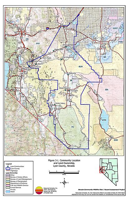
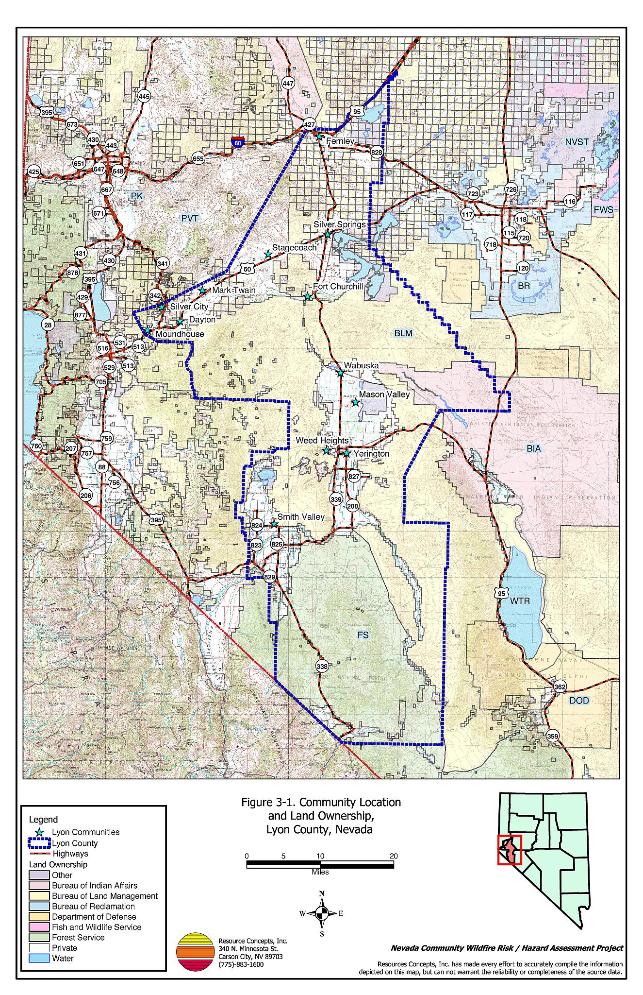
Lyon County is located in western Nevada and is approximately 1,290,600 acres in size.A summary of land management administration is provided in Table 3-1 and presented in Figure 3-1. Agencies listed in the “Other” category include the US Fish and Wildlife Service (15 acres) and open water.
| Land Administrator | Acreage |
|---|---|
| BLM | 576,667 |
| Forest Service | 274,274 |
| State of NV | 34,129 |
| BIA | 50,315 |
| Private | 337,420 |
| Other | 17,798 |
| Source: BLM land ownership GIS database | |
In 2003 the Nevada State Demographer’s Office estimated the county population to be 41,244. The Lyon County economy is based primarily in trade, services, manufacturing, and government. The State Demographer’s Office lists Amazon.com and Odyssey Business Services as the largest employers in the county.
The highest elevation in Lyon County is approximately 10,402 feet at East Sister Peak in the Sweetwater Mountains. The lowest elevation is approximately 4,014 feet at the Fernley Sink, which is part of the Fernley Wildlife Management Area.
Major mountain ranges in Lyon County include the Pine Grove Hills, Desert Mountains, Pine Nut Mountains, Virginia Range, Singatse Range, and Sweetwater Mountains. The largest valleys in Lyon County include Mason Valley, Smith Valley, Churchill Valley, and the Carson Plains.
3.2 Wildfire History
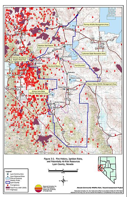
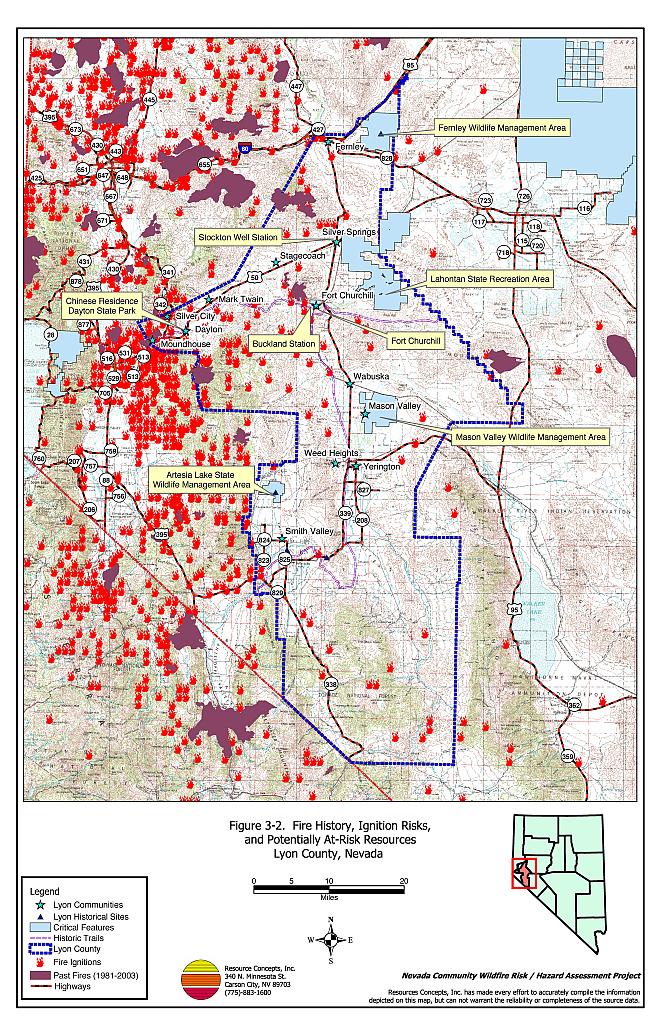
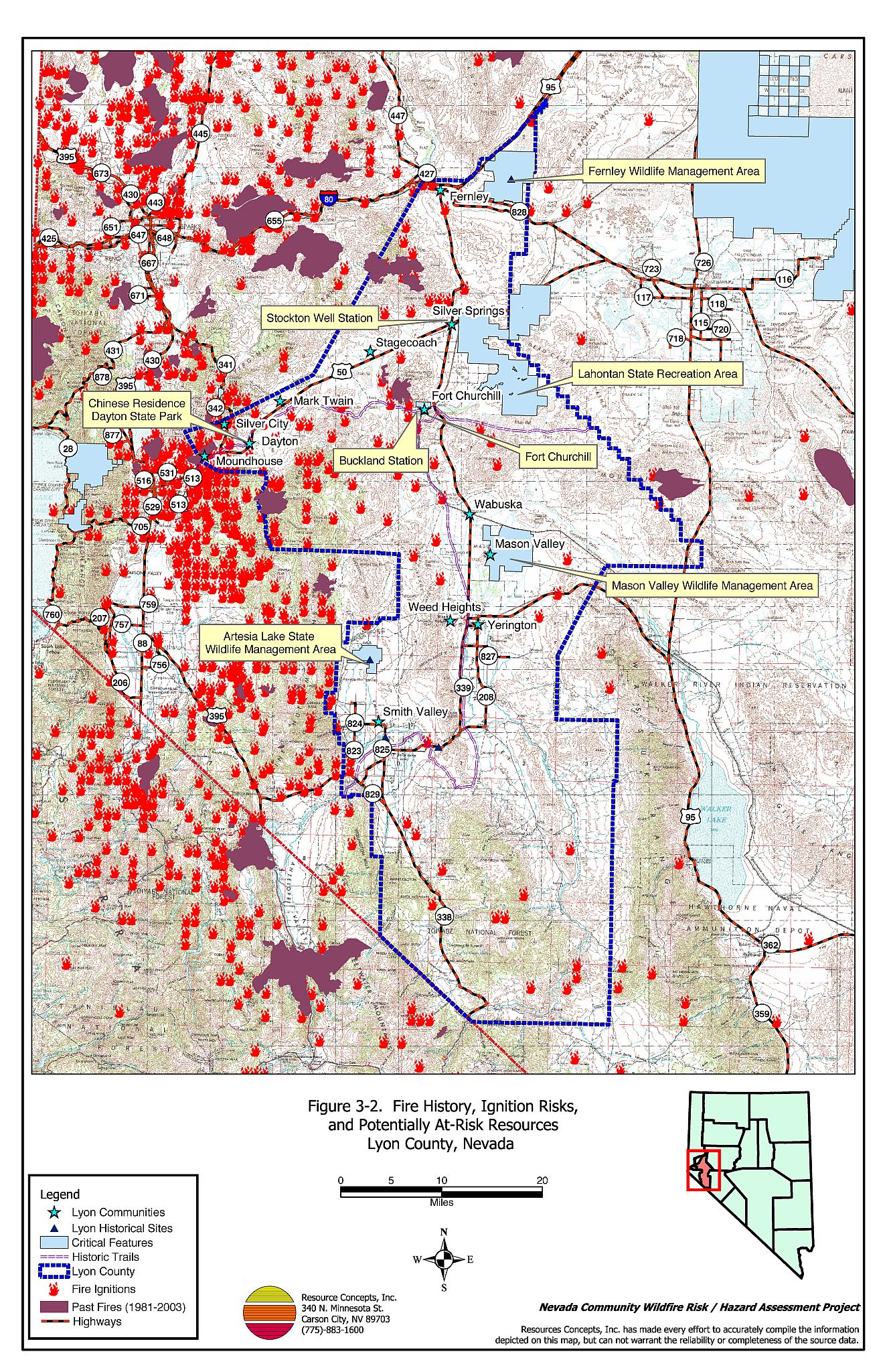
The fire history of Lyon County was researched through the Nevada BLM State Office. There have been a few significant wildfires in the recent history of Lyon County. From 1980 through 2003, 32,968 acres, 2.5 percent of Lyon County burned in wildland fires. The largest fire recorded in the county was the Gooseberry Mine fire in 1985 that started in Storey County and burned approximately 13,472 acres in Lyon County. The wildfire history within the county is illustrated in Figure 3-2. Wildfire history and the number of wildfire ignitions each year is summarized in Table 3-2. Interviews with Central Lyon County Fire Protection District Chief John Gillenwater indicated several additional small fires on private property. Smith Valley Fire Protection District Chief Jim Hard also pointed out several fires that occurred on National Forest land in the Sweetwater Range that are not included on Figure 3-2 or in Table 3-2 (Reinhardt, pers. comm.). No additional information was available to describe the additional wildfires that were not included in the database.
| Year | Number of Fire Ignitions | Total Fire Acreage |
|---|---|---|
| 1980 | 5 | 1 |
| 1981 | 5 | 4,080 |
| 1982 | 3 | 5 |
| 1983 | 3 | 1,015 |
| 1984 | 10 | 846 |
| 1985 | 12 | 14,017 |
| 1986 | 12 | 2,733 |
| 1987 | 10 | 150 |
| 1988 | 3 | 0 |
| 1989 | 3 | <1 |
| 1990 | 5 | 10 |
| 1991 | 9 | 1 |
| 1992 | 9 | 6 |
| 1993 | 2 | 1 |
| 1994 | 6 | 1 |
| 1995 | 7 | 181 |
| 1996 | 5 | 3,418 |
| 1997 | 4 | 2 |
| 1998 | 2 | 0 |
| 1999 | 2 | 1 |
| 2000 | 4 | 6,464 |
| 2001 | 10 | 3 |
| 2002 | 2 | 0 |
| 2003 | 2 | 28 |
| TOTAL | 135 | 32,963 |
| Source: Fire ignition and base acreage data provided by the National Interagency Fire Center, Boise, Idaho. Additional fire history information provided by Jim Reinhardt, personal communication | ||
3.2.1 Ignition Risk Factors
Ignition risks for wildfires fall into two categories: lightning and human caused. Human caused ignitions can come from a variety of sources such as burning material thrown out of vehicle windows or ignited during auto accidents; off-road vehicles; railroads; arcing power lines; agricultural fires; campfires; debris burning in piles or burn barrels; matches; and fireworks. In Lyon County, database records indicate that 83 of the 135 wildland fire ignitions recorded between 1980 and 2003 were caused by lightning and 34 were human caused. The cause for the remaining fires was not reported.
3.2.2 Effect of Cheatgrass on Fire Ecology
The science of fire ecology is the study of how fire contributes to plant community structure and species composition. A “fire regime” is defined in terms of the average number of years between fires under natural conditions (fire frequency) and fire severity (the amount of dominant vegetation that is removed by fire). Natural fire regimes have been affected throughout most of Nevada by twentieth century fire suppression policies. Large areas that formerly burned with high frequency but low intensity (fires more amenable to control and suppression) are now characterized by large accumulations of unburned fuels, that when ignited will burn at higher intensities.
Big sagebrush is the most common plant community in Nevada with an altered fire regime, now characterized by infrequent, high-intensity fires. Sagebrush requires 10-20 or more years to reestablish on burned areas. During the interim period, these areas can provide the conditions for establishment and spread of invasive species and in some cases inhibit sagebrush reestablishment. The most common invasive species to reoccupy burned areas in northern Nevada is cheatgrass (Bromus tectorum).
Cheatgrass is a common, introduced annual grass that aggressively invades disturbed areas, especially burns. Replacement of a native shrub community with a pure stand of cheatgrass increases the susceptibility of an area to repeated wildfire ignitions, especially in late summer when desiccating winds and lightning activity are more prevalent. Dried cheatgrass creates a highly flammable fuel bed that is readily susceptible to ignition. The annual production of cheatgrass is variable with plants ranging from a few inches tall, to over two feet tall on the same site depending upon winter and spring precipitation. In an above normal precipitation year, cheatgrass-dominated rangelands can be considered a high hazard fuel type.
During normal and dry years, cheatgrass is generally sparse and low in stature and poses a low fire behavior hazard. However the cheatgrass fuel bed is still readily ignited with the propensity to rapidly burn into adjacent unburned cover types that may have higher potential for hazardous fire behavior. The ecologic risk of a fire spreading from a cheatgrass stand into an adjacent, unburned native cover type is that additional disturbed areas are thereby opened and vulnerable to cheatgrass invasion. Associated losses of natural resource values such as wildlife habitat, soil stability, and watershed functions may also occur.
The strategy to control cheatgrass once it has become established is to deplete the seed harbored in the soil by annual mowing or grazing early in the growing season during flowering and before seed set.
3.3 Natural Resources and Critical Features Potentially at Risk
Critical features at risk of loss during a wildfire event can be economic assets such as agricultural and industrial resources or cultural features, such as historic structures, archaeological sites, and recreation-based resources.
3.3.1 Historical Sites
Two Historic Registers were researched for this report. There are eight sites listed on the National Register of Historical Places for Lyon County. The Nevada State Register of Historical Places lists six sites. The four Historic Districts and resources that lie in the wildland-urban interface and that could be negatively impacted by wildfire are summarized in Table 3-3.
| Site Name | Location |
|---|---|
| Buckland Station | Weeks |
| Fort Churchill - Weeks | Weeks |
| Stockton Well Station | Silver Springs |
| Chinese Residence | Dayton |
3.3.2 Recreation
The Nevada Department of Wildlife manages the Mason Valley Wildlife Management Area (12,132 acres), Fernley Wildlife Management Area (13,586 acres), and Artesia Lake Wildlife Management Area (3,429 acres) in Lyon County. These state lands provide habitat for numerous species of waterfowl and upland birds. The vegetative fuel accumulation in some of these areas is of concern. Upland habitats and facility structures are at risk if a wildfire were to occur, especially in the Mason Valley Wildlife Area.
The Lahontan State Recreation Area is located on the east side of Lyon County. Approximately 27,776 acres of the State Recreation Area is located within Lyon County, with the remaining 10,598 acres in Churchill County. Facilities include restrooms, picnic, and campground areas. The locations of these features are shown on Figure 3-2.
3.3.3 Flora and Fauna
The bald eagle (Hailaeetus leucocuphalus). a federally listed threatened species, has potential habitat in Lyon County. An additional sixteen species of sensitive taxa with potential habitat in Lyon County are protected by state legislation (Nevada Natural Heritage Program database; last updated for Lyon County in March 2004). These species are identified in Table 3-4. The Nevada Natural Heritage Program, the Nevada Division of Forestry, and the Nevada Department of Wildlife should be consulted regarding specific concerns and potential mitigation to minimize impacts to these species prior to the event of a catastrophic wildfire.
| Scientific name | Common name | Legislation |
|---|---|---|
| Plants | ||
| Opuntia pulchella | Sand cholla | NRS 527.060.120 |
| Polyctenium williamsiae | Williams combleaf | NRS 527.260.300 |
| Mammals | ||
| Euderma maculatum | Spotted bat | NRS 501 |
| Lontra canadensis | River otter | NRS 501 |
| Birds | ||
| Accipiter gentilis | Northern goshawk | NRS 501 |
| Athene cunicularia hypugaea | Western burrowing owl | NRS 501 |
| Buteo regalis | Ferruginous hawk | NRS 501 |
| Buteo swainsoni | Swainson’s hawk | NRS 501 |
| Centrocercus urophasianus | Greater Sage-grouse | NRS 501 |
| Charadrius alexandrinus nivosus | Western snowy plover | NRS 501 |
| Childonias niger | Black tern | NRS 501 |
| Coccyzus americanus occidentalis | Western yellow-billed cuckoo | NRS 501 |
| Falco peregrinus | Peregrine falcon | NRS 501 |
| Hailaeetus leucocuphalus | Bald eagle | Federally Listed Threatened NRS 501 |
| Otus flammeolus | Flammulated owl | NRS 501 |
| Plegadis chichi | White-faced ibis | NRS 501 |
| Strix occidentalis occidentalis | California spotted owl | NRS 501 |
3.4 Previous Fire Hazard Reduction Projects
No previous fuel hazard mitigation projects were reported by the fire agencies in Lyon County. A weed abatement program is enforced in the Mason Valley Fire Protection District and serves as a tool for reducing fuel hazards associated with weed infestations.
Figure 3-1Community Location and Land Ownership, Lyon County, Nevada |
 |
Figure 3-2Fire History, Ignition Risks, and Potentially At Risk Resources Lyon County, Nevada |
 |