![]()
![]()
10.0 Mound House
10.1 Hazard and Risk Assessment
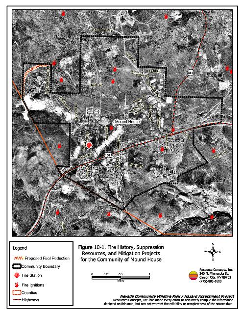
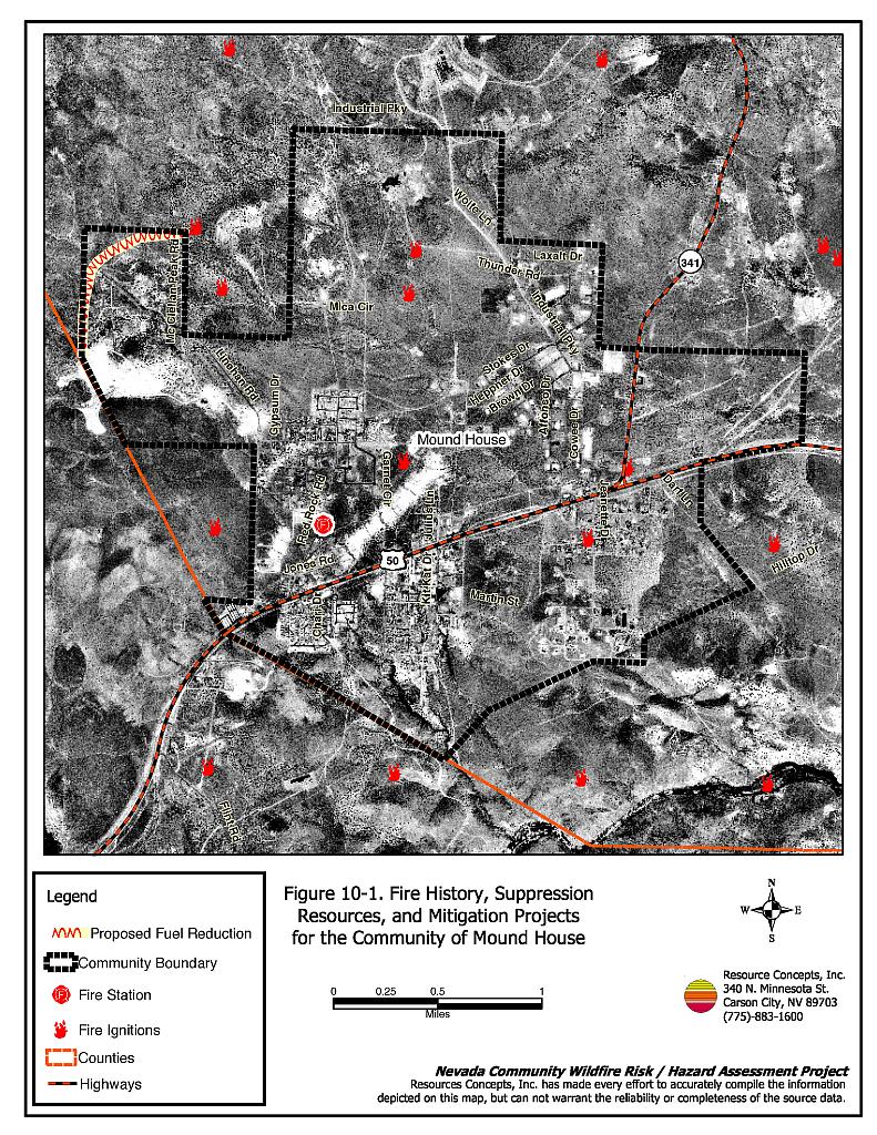
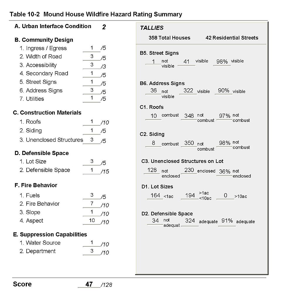
The Mound House community is located in the northwest portion of Lyon County, adjacent to the Carson City and Storey County lines (see Figure 10-1). Mound House is bordered to the north by the Virginia Range, to the south by Santiago and Eureka Canyons, to the west by Carson City, and to the east by Dayton Valley. A total of 358 residences were evaluated during this assessment. The risk/hazard assessment resulted in classifying Mound House in the Moderate Hazard category (47 points). However, the northwest portion of Mound House alone could be classified in the High Hazard category due to the high fuel load. The moderate community hazard score is attributed primarily to potential fire behavior and fuel loads in the area. The community wildfire hazard score sheet is provided at the end of this section. The specific findings for each of the wildland fire assessment parameters are reported below.
10.1.1 Community Design
The urban interface condition in Mound House can be described as both intermix and classic interface. In many areas subdivisions border wildland fuels with a clear line of demarcation between the fuels and the residences. However, where homes have been built on larger lots, wildland fuels are often contiguous up to each residence. Lot sizes vary throughout Mound House with about half of the lots less than one acre in size, and half of the lots in the one to ten acre size range. Structure spacing varies according to lot size.
Roads: The primary access route in Mound House is US Highway 50, which is a paved highway greater than 24 feet wide. Other primary access roads for residences on the north side of the highway include Linehan Road, Red Rock, and State Route 341. Primary access roads for residences on the south side of the highway include Jeanette Drive and Highlands Drive. Most of the primary roads are between 20 and 24 feet wide and allow adequate room for fire suppression equipment to maneuver.
Signage: Most streets in Mound House have standard metal street signs that are highly visible and easy to read. Residential addresses are easily visible on a majority of homes in Mound House. The clear and visible signage throughout the Mound House area will assist fire suppression personnel in locating residences during poor visibility conditions that may exist during a wildland fire.
Utilities: The utilities that serve Mound House are a combination of above ground and below ground power lines with scattered areas served by propane. In general utilities have adequately maintained right-of-ways and pose only a low ignition risk to the community.
10.1.2 Construction Materials
A majority of the homes observed in the interface area were built with fire resistant siding materials. A great majority of the homes had fire resistant roof materials such as composition shingles, metal, or tile roofing. About one-third of the homes observed had unenclosed balconies, porches, decks or other architectural features that can create drafty areas where sparks and embers can be trapped, smolder, and ignite, rapidly spreading fire to the home.
10.1.3 Defensible Space
The majority of the homes had landscaping that would meet the defensible space requirement to protect the home from damage or minimize loss during a wildfire.
10.1.4 Suppression Capabilities
Wildfire Protection Resources
The Central Lyon County Fire Protection District provides wildfire protection. Refer to Section 4.2 for more information on equipment and resources available.
Water Sources and Infrastructure
Water availability for fire suppression in Mound House includes:
- Community wells with one 100,000 gallon storage tank, one 500,000 gallon storage tank, one 600,000 gallon storage tank, one 1-million gallon storage tank
- 500 gpm hydrants that vary between 500 and 1,000 feet from structures, and
- A water storage tank.
The community water system operates on gravity and electric pumps with a backup generator. The entire system was upgraded over the last three years.
10.1.5 Factors Affecting Fire Behavior
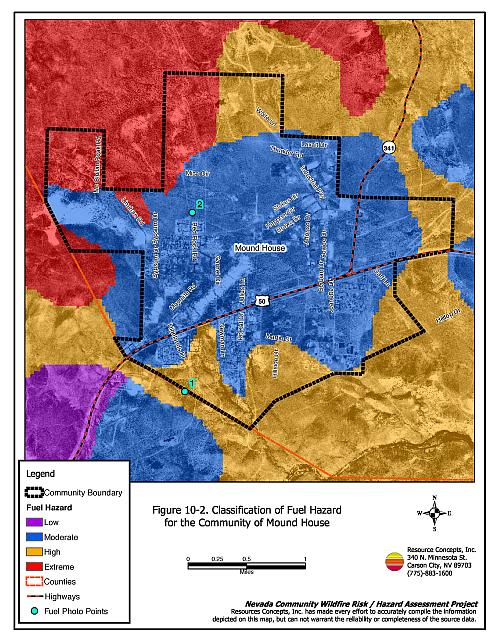
Fuel hazard mapping and photo point locations are shown on Figure 10-2; photo points are shown in Figure 10-3. Fuels along the west, south, and east sides of Mound House were composed of a shrub layer of sagebrush, rabbitbrush, and Mormon tea with scattered single-leaf pinyon and Utah juniper trees. Grasses included Sandberg bluegrass, bottlebrush squirreltail, and cheatgrass. Shrubs in this area generally ranged between one and two feet in height. The total fuel load was estimated between one and three tons per acre, a moderate fuel hazard.
The north side of the community was characterized by a pinyon-juniper tree canopy, with a shrub understory of big sagebrush, antelope bitterbrush, rabbitbrush, and Mormon tea. Grasses in this area included bottlebrush squirreltail, Great Basin wildrye, Sandberg bluegrass, and cheatgrass. The total fuel load was estimated to be between two and six tons per acre and was classified as an extreme fuel hazard.
The dry wash running from the center to the south end of the community was characterized by a pinyon-juniper tree layer, with big sagebrush, greasewood, rabbitbrush, and Mormon tea in the shrub layer. Shrubs were generally four to six feet in height in the wash. The ground fuels consisted of Great Basin wildrye, bottlebrush squirreltail, and cheatgrass. Fuel loads in the wash were estimated at three to four tons per acre and classified as a high fuel hazard.
The community of Mound House sits in a topographic “saddle” with variable topography around the community. The topography is characterized by slopes up to 10 percent, narrow canyons south of the community, and steeper mountains and foothills to the north and northwest.
10.1.6 Fire Behavior Worst-case Scenario
The worst-case fire behavior scenario would likely occur on a high hazard summer day, in a year with normal to above normal precipitation and high cheatgrass production. An ignition west of the community would rapidly spread through the sagebrush and pinyon-juniper fuel if driven by west or southwest winds. Flame lengths of a wind-driven fire in this fuel type could reach four to 10 feet in length spreading the fire at an estimated rate of approximately 1,300 to 2,600 feet per hour. Spotting (or flying embers) could occur for distances of 1,000 feet.
10.1.7 Ignition Risk Assessment
Mound House has a high risk of fire ignition based on the history of summer afternoon lightning strikes and the moderate to extreme fuel hazards.
10.2 Risk and Hazard Reduction Recommendations, Roles, and Responsibilities
The responsibility to keep a community fire safe falls not only on the local fire protection district but also on the residents of the community, businesses, and local governments. The recommendations for Mound House focus primarily on additional efforts that can be taken by community members and public agencies to increase wildfire safety through reduction of hazardous fuels. Other recommendations pertain to community coordination and public education efforts that could be undertaken to enhance fire safety in Mound House. The recommendations are detailed below and summarized in Table 10-1.
10.2.1 Defensible Space Treatments
The density and type of fuel around a home affects the potential fire exposure levels to the home. The goals of defensible space are to reduce the chances of a wildfire spreading onto adjacent property and igniting homes, and to reduce the risk of property loss from wildfire. General guidelines for creating defensible space around residences and structures in the community are given below and are described in detail in Appendix E.
Property Owner Responsibilities
- Remove, reduce, and replace vegetation to create defensible space around homes according to the guidelines in Appendix E. This area should be kept:
- Lean: There are only small amounts of flammable vegetation
- Clean: There is no accumulation of dead vegetation or other flammable debris
- Green: Existing plants are healthy and green during the fire season.
- Immediately dispose of cleared vegetation when implementing defensible space treatments. This material dries quickly and poses a fire hazard if left on site.
- Maintain defensible space annually or as needed to keep the space lean, clean, and green.
- Store firewood a minimum distance of 30 feet from structures.
- Maintain a minimum clearance of 30 feet from the crown of trees that remain within the defensible space zone. Keep this area free of smaller trees, shrubs, and other ladder fuels.
- Trim and remove tree branches a minimum of 4 feet from the ground to reduce ladder fuels on all deciduous and coniferous trees within the defensible space zone. Prune all dead and diseased branches.
- Mow or remove brush growing against wood fences in the community.
- Maintain areas under wood decks and porches free of weeds and other flammable debris. Install screens around unenclosed overhangs where possible.
- Clear all vegetation and combustible materials around propane tanks for a minimum distance of 10 feet.
10.2.2 Fuel Reduction Treatments
Creation of a shaded fuel break is recommended to reduce the potential fire hazard to homes in the northern part of the community. The objective of this fuel reduction treatment is to create an area of lower fire intensity and improve opportunities to protect homes in the interface area.
Property Owner Responsibilities
- Construct a shaded fuelbreak from the Art Wilson Gypsum Pit north to the end of McClellan Peak Road. Use a masticator such as a brush hog, hydro-axe, or Bull Hog to masticate brush and pinyon-juniper trees or cut trees and remove the biomass. Pinyon and juniper trees should be thinned to a spacing of two times the height of the trees between crowns. The remaining trees should be limbed four to five feet from the ground. Brush should be thinned to a spacing of two times the height of the shrubs between crowns. Broadcast seed the area with the pre-suppression seed mix included in Appendix E. The shaded fuelbreak should be 120 to 240 feet wide and approximately one mile in length, or approximately 15 to 30 acres.
Bureau of Land Management Responsibilities
- Work with private property owners to implement the above shaded fuelbreak where its location is recommended on BLM lands.
10.2.3 Community Coordination
Coordination among local, state, and federal fire suppression agencies is important in the day-to-day fire prevention activities and becomes critical in the event of a wildland fire. During a wildfire event, firefighters from other communities and states may be dispatched to protect areas they have never been before. This is particularly true in areas that have limited fire suppression resources and will most likely depend on outside assistance in the event of a catastrophic wildland fire. The following are recommendations should be implemented in Mound House to promote interagency and community coordination.
Property Owner Responsibilities
- Form a local chapter of the Nevada Fire Safe Council. The Nevada Fire Safe Council facilitates solutions to reduce the loss of lives and property from the threat of wildfire in Nevada’s communities. Through the establishment of a local chapter, local communities will become part of a large network for sharing information and receive notifications of programs and funding opportunities for fire mitigation projects such as those listed in this report. The Nevada Fire Safe Council will accept and manage grants and contracts on the chapter’s behalf through its non-profit status. The Nevada Fire Safe Council will provide assistance and support to communities to complete fire safe plans, set priorities, educate and train community members, and promote success stories of its members. To form a local chapter, or for more information contact the:
Nevada Fire Safe Council
1187 Charles Drive
Reno, Nevada 89509
(775) 322-2413
www.nvfsc.org - Assure that residential addresses are visible from the road. Address characters should be at least four inches high, reflective, and composed of non-flammable material. Improving visibility of addresses will make it easier for those unfamiliar with the area to navigate an area under smoky conditions in the event of a wildland fire.
Lyon County Sheriff Responsibilities
- Work with homeowners to identify non-ambulatory persons within the community that may need evacuation assistance.
10.2.4 Public Education
Increased public education on fire safety is critical in communities that have rapidly growing populations, especially when many of the areas being developed are larger lots intermixed with wildland fuels. People moving into the area may be unfamiliar with fire-prone environments.
Central Lyon County Fire Protection District Responsibilities
- Distribute copies of the publication Living with Fire to all property owners. This publication is free of charge. Copies can be requested from the University of Nevada Cooperative Extension.
- Enforce or develop county laws, regulations, and ordinances that support implementation and maintenance of defensible space and address fuel reduction responsibilities for absentee homeowners and vacant lots.
- Contact the University of Nevada Cooperative Extension and the BLM Carson City Field Office for assistance with public education.
10.3 Summary of Recommendations
| Responsible Party | Recommended Treatment | Recommendation Description |
|---|---|---|
| Property Owners | Defensible Space Treatments | Remove, reduce, and replace vegetation around homes according to the guidelines in Appendix E. Maintain defensible space as needed to keep the space lean, clean, and green. |
| Fuel Reduction Treatments | Install a shaded fuelbreak according to the specifications given in Section 10.2.2. | |
| Community Coordination | Form a local chapter of the Nevada Fire Safe Council. Improve address visibility. |
|
| BLM | Fuel Reduction Treatments | Install a shaded fuelbreak according to the specifications given in Section 10.2.2. |
| Lyon County Sheriff | Community Coordination | Work with homeowners to identify non-ambulatory persons within the community for evacuation assistance. |
| Central Lyon County Fire Protection District | Public Education | Distribute copies of the publication Living with Fire. to all property owners. Enforce or develop county laws and ordinances for defensible space and fuel reduction responsibilities for absentee owners and vacant lots. Contact Nevada Cooperative Extension and the BLM for assistance with public education. |
Figure 10-1Fire History, Suppression Resources, and Mitigation Projects for the Community of Mound House |
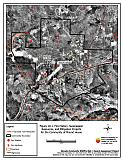 |
Figure 10-2Classification of Fuel Hazard for the Community of Mound House |
 |
Fuel Hazard Photo Points for the Mound House Community

Photo Point 1. 4342964 N. 0269207 E. Direction 330°NW. Fuels along the west, south, and east sides of Mound House are primarily composed of a shrub canopy layer of sagebrush, rabbitbrush, and Mormon tea, with scattered singleleaf pinyon and Utah juniper trees. Grass species include Sandberg bluegrass, bottlebrush squirreltail, and cheatgrass. The total fuel load was estimated to range between one and three tons per acre.
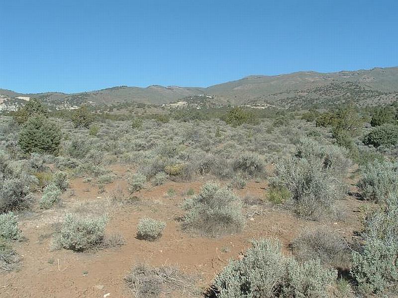
Photo Point 2. 4345412 N. 0267438 E. Direction 290°NW. Structures in heavy fuels on the north side of the community are characterized by a pinyon-juniper tree canopy, with a big sagebrush, antelope bitterbrush, rabbitbrush, and Mormon tea shrub canopy. Grass species in this area are bottlebrush squirreltail, basin wildrye, Sandberg bluegrass and cheatgrass. The total fuel load is estimated to be between two and six tons per acre and classified as an extreme fuel hazard.
Mound House Wildfire Hazard Rating Summary |
 |