![]()
![]()
3.0 Description Of The Municipality
3.1 Demographics, location, topography, and climatic data
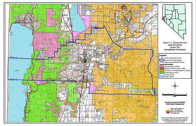
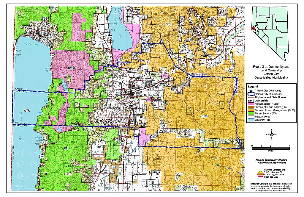
The Carson City Consolidated Municipality is located in western Nevada and is approximately 97,920 acres in size, one of the country’s largest state capitals.A jurisdictional summary of land management administration and coverage including water is provided in Table 3-1 and presented in Figure 3-1. The majority of land within the municipality is administered and managed by federal agencies. The federal agency policies and decisions on lands located near the wildland-urban interface areas may have direct effects on private landowners within the municipality.
| Land Administrator | Approximate Acreage |
|---|---|
| BLM | 41,070 |
| USFS | 10,000 |
| State of NV | 3,920 |
| Private | 31,590 |
| Bureau of Indian Affairs | 480 |
| Carson City | 5,050 |
| Water | 7,510 |
| Approximate values derived from BLM land ownership GIS and Carson City Assessor’s Office databases. | |
The 2003 population estimate for the municipality was 55,220 persons (Nevada State Demographer). The municipality economy is based primarily in government, trade, and services. The State Demographer’s Office lists Chromalloy Nevada, Harley-Davidson Credit Corporation, Mission Industries, Thys Company, and Weddell, R.P. & Sons as the largest private employers in the municipality.
The majority of residential development in the municipality is located in Eagle Valley and the foothill areas that surround the historic town. The highest elevation within the municipality is 9,214 feet at Snow Valley Peak. The lowest elevation is 4,480 feet along the Carson River near the Lyon County border. The major mountain ranges and mountain features in the municipality include the Carson Range, C-Hill, Virginia Range, Pine Nut Mountains, and Prison Hill. The average annual precipitation is 10.4 inches (Western Regional Climate Center website).
3.2 Wildfire History
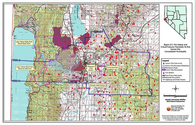
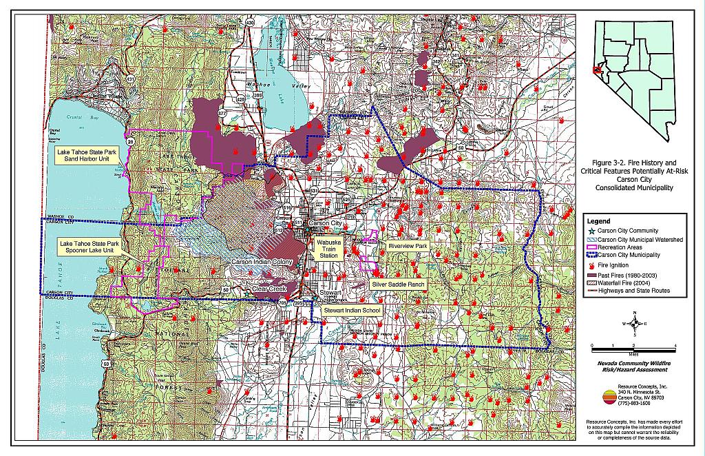
Significant wildland fires have occurred in the municipality over the last 24 years. Table 3-2 summarizes the fire histories and fire ignitions by year recorded for public lands in the Carson City Consolidated Municipality. Figure 3-2 illustrates the fire history in the vicinity of Carson City. Several wildland fires have occurred on private lands within the municipality that are not reflected in Table 3-2 and Figure 3-2.
| Year | Number of Fire Ignitions | Total Fire Acreage |
|---|---|---|
| 1980 | 7 | 161 |
| 1981 | 2 | 356 |
| 1982 | 2 | 3 |
| 1983 | 8 | 2,670 |
| 1984 | 8 | 600 |
| 1985 | 10 | 7 |
| 1986 | 8 | 81 |
| 1987 | 10 | 485 |
| 1988 | 14 | 1,798 |
| 1989 | 2 | 1 |
| 1990 | 8 | NA |
| 1991 | 9 | 4 |
| 1992 | 3 | 1 |
| 1993 | 3 | 1 |
| 1994 | 1 | 35 |
| 1995 | 2 | <1 |
| 1996 | 8 | 225 |
| 1997 | 3 | 5 |
| 1998 | 1 | 40 |
| 1999 | 14 | 1,027 |
| 2000 | 13 | 101 |
| 2001 | 8 | 55 |
| 2002 | 6 | 9 |
| 2003 | 6 | 691 |
| TOTAL | 156 | 8,356 |
| Source: National Interagency Fire Center, Boise, Idaho, Bureau of Land Management, and US Forest Service. NA - either no acreage was reported in the databases, or the acreage was too small to be recorded in the database. | ||
Ignition risks for wildfires fall into two categories - lightning and human caused. Human caused ignitions can come from a variety of sources: fires started along highways and roads from burning material thrown out of vehicle windows or ignited during auto accidents, off-road vehicles, arcing power lines, agricultural fires, ditch burning, debris burning in piles or burn barrels, unextinguished matches, target shooting, and fireworks. Database records indicate that 131 of the 156 ignitions were recorded according to ignition source. Of these ignitions, 47 percent were due to natural causes and 53 percent were human caused.
3.2.1 2004 Waterfall Fire
At 3:15 a.m. on Wednesday July 14, 2004, the Waterfall Fire started in Kings Canyon just west of the Carson City Community. It was human-caused from an illegal, abandoned campfire. In the seven days until containment, 8,799 acres burned and the total suppression cost was estimated at eight million dollars. Within the first three days of the fire, over 98,300 gallons of retardant were dropped, three fire apparatus were lost, and five firefighters and one civilian were injured. Over 1,075 homes and businesses were threatened, 66 structures and outbuildings were lost or damaged, and over 1,000 homes evacuated. Fortunately, there were no fatalities.
3.2.2 Fire Ecology
The science of fire ecology is the study of how fire contributes to plant community structure and species composition. A “fire regime” is defined in terms of the average number of years between fires under natural conditions (fire frequency), in combination with the severity of fires on the dominant vegetative species. Natural fire regimes have been affected throughout most of Nevada by twentieth century fire suppression policies. Large areas that formerly burned with high frequency but low intensity (fires more amenable to control, suppression, and rehabilitation) are now characterized by large accumulations of unburned fuels, which once ignited, will burn at higher intensities.
Some plant communities have evolved to burn frequently with low intensity, for example mature Jeffrey pine forests. Under a native fire regime, low-intensity surface fires reduce fuel loading from grasses and shrubs, suppress regeneration of shade-tolerant white fir seedlings, and leave the adult Jeffrey pine trees unaffected, protected by thick, fire-resistant bark. Forests with frequent fire occurrence often have an open, “park-like” appearance with an understory of grass or low shrubs. Though shaded by large, mature trees, spacing between trees is sufficient to allow sunlight to reach the forest floor and encourage regeneration of shade-intolerant species like Jeffrey pine. Pockets of heavy fuels exist in these conditions, but their discontinuous nature reduces the likelihood that a fire will burn with enough intensity to negatively impact mature trees. In the absence of frequent surface fires, accumulated dead-and-down woody fuels and the green “ladder fuels” can carry flames into the coniferous overstory, potentially provoking a catastrophic, stand-destroying crown fire.
Big sagebrush communities are the most common vegetation types in Nevada with an altered fire regime, now characterized by infrequent, high-intensity, catastrophic fires. Sagebrush requires ten to twenty or more years to reestablish on burned areas, and most often these areas provide the conditions for establishment and spread invasive species before sagebrush reestablishment can occur. The most common invasive species to reoccupy both sagebrush and pinyon-juniper burned areas in northern Nevada is cheatgrass (Bromus tectorum).
Effect of Cheatgrass on Fire Ecology
Cheatgrass is a common, introduced annual grass that aggressively invades disturbed areas, especially burns. Replacement of a native shrub community with a pure stand of cheatgrass increases the susceptibility of an area to repeated wildfire ignitions, especially in late summer when desiccating winds and lightning activity are more prevalent. The annual production, or volume of cheatgrass fuel produced each year, is highly variable and dependent on winter and spring precipitation. Plants can range from only a few inches tall in a dry year to over two feet tall on the very same site in wet years. In a normal or above normal precipitation year, cheatgrass can be considered a high hazard fuel type. In dry years, cheatgrass is generally sparse and low in stature and poses a low fire behavior hazard because it tends to burn with a relatively low intensity. Nevertheless, in every year dried cheatgrass creates a highly flammable fuel bed that is easily ignited with the propensity to rapidly burn into adjacent cover types that may be characterized by more severe and hazardous fire behavior. The ecologic risk of a fire spreading from a cheatgrass stand into adjacent, unburned native vegetation is that additional disturbed areas are thereby opened and vulnerable to cheatgrass invasion. Associated losses of natural resource values such as wildlife habitat, soil stability, and watershed functions are additional risks.
Eliminating cheatgrass is an arduous task. Mowing defensible space and fuelbreak areas annually before seed maturity is effective in reducing cheatgrass growth. In areas where livestock may be utilized, implementing early-season intensive grazing up to and during flowering may aid in depleting the seed bank and reduce the annual fuel load (BLM 2003, Davison and Smith 2000, Montana State University 2004). It may take years and intensive treatment efforts to control cheatgrass in a given area, but it is a desirable conservation objective in order to revert the landscape to the natural fire cycle and reduce the occurrence of large, catastrophic wildfires. Community-wide efforts in cooperation with county, state, and federal agencies are necessary for successful cheatgrass reduction treatments.
Effect of Fire on Russian Knapweed
Following the 2004 Waterfall fire, Russian knapweed, a state-listed noxious weed, was discovered in Kings Canyon, both on private property and lands owned by Carson City. Observations of Russian knapweed in Kings Canyon indicate that the species is stimulated by fire. The plant resprouted within days following the burn and its distribution is believed to be increasing rapidly. The University of Nevada Cooperative Extension, in cooperation with the Carson City Consolidated Municipality, has initiated specific treatments to control and hopefully eradicate this noxious weed in the affected areas. If not dealt with expediently, it will continue to spread and displace desired plant species. More information on Russian knapweed is included in Appendix E.
3.3 Natural Resources and Critical Features Potentially at Risk
Critical features at risk of loss during a wildfire event can be economic assets such as agricultural and industrial resources or cultural features, such as historic structures, archaeological sites, and recreation-based resources.
3.3.1 Municipal Watershed
Approximately 5,705 acres (or 63 percent) of the 9,041-acre Carson City municipal watershed (includes Kings Canyon, Ash Canyon, and Vicee Canyon subwatersheds) burned in the 2004 Waterfall Fire. Significant risks, hazards, and costs to the City’s municipal water system are likely to be incurred due to the large percentage of the watershed that burned. Erosion and sedimentation are likely to affect the performance and maintenance of the Quill water treatment facility. Water storage capacity reductions of 15 percent in the summer and up to 67 percent in the winter are expected to occur at the Quill facility. Estimated damage costs associated with the occurrence of moderate to catastrophic runoff events range from $10,000 to $5 million for repair and increased maintenance of the facility (Forest Service FSH 2509.13, 2004). Additionally, mudslide hazards will be present until vegetation establishes in the burned areas, which leaves homes, roads, pipelines, and other municipal infrastructure at risk of loss.
3.3.2 Historical Registers
Two Historic Registers were researched for this report. There are 41 sites listed on the National Register of Historical Places for the Carson City Consolidated Municipality. The Nevada State Register of Historical Places lists seventeen sites. The historic buildings that lie in the wildland-urban interface and could be negatively impacted (damaged or destroyed) by wildfire are summarized in Table 3-3 and shown on Figure 5-1.
| Site Name | Location | Source Register |
|---|---|---|
| Stewart Indian School | South Carson City | National Register of Historic Places |
| Wabuska Railroad Station | South Carson Street | National Register of Historic Places |
3.3.3 Recreation
Spooner Lake Unit of the Lake Tahoe State Park is located within both the Carson City Consolidated Municipality and Douglas County; it is managed by the Carson-Tahoe Region Headquarters of the Nevada Division of State Parks. There are several structures within the 2,800 acre park including a maintenance building, well house, restroom, cross-country ski lodge, fee booth and entrance station, historic sheepherder’s cabin, water tender’s cabin, and two rental cabins. None of the structures are inhabited year-round, and all structures within the Park are constructed of either wood siding or logs and have composite, asphalt, or metal roofs. No hydrants or water storage drafting sources are available for structure fire protection; however, water can be drafted out of nearby Spooner Lake.
Approximately 120,000 people visit the park annually and the estimated daily summer weekend visitation is 525 persons. The Park management has developed an informal evacuation plan that they used to evacuate the Park during the 2004 Waterfall Fire. The Nevada Division of Forestry is the primary fire suppression agency responsible for the State Park. The Parks Division has received some funding for fuel reduction treatments along corridors outside of the Lake Tahoe Basin and plans on implementing the projects in the fall of 2004. They have also received funding from the Environmental Improvement Program for fuels reduction and forest health treatments for the areas of the park within the Lake Tahoe Basin (Kosch pers. comm.).
The Humboldt-Toiyabe National Forest, Carson Ranger District (USFS) has completed several fuels reduction treatments south of the Spooner Lake State Park. Approximately 400 acres were treated approximately ten years ago through a salvage timber sale and hand crew treatments of cut, pile, and burn.
Riverview Park is located on the east side of the Carson City community along the Carson River (Figure 3-2). The park features trails, exercise signs, wildlife viewing, and restroom facilities. Wildfires would potentially damage wildlife habitat and could reduce recreational interest.
The Silver Saddle Ranch is owned and operated by the Bureau of Land Management. The Silver Saddle Ranch features trails, historic buildings, restrooms, and corrals. Wildfires would damage wildlife habitat and could reduce recreational interest.
3.3.4 Flora and Fauna
There is one federally listed endangered species with potential habitat in the municipality. Projects implemented to protect habitat for this species require formal consultation with the US Fish and Wildlife Service. An additional fourteen species are protected by Nevada state legislation and are identified in Table 3-4. The Nevada Natural Heritage Program, the Nevada Division of Forestry, and the Nevada Department of Wildlife should be consulted regarding specific concerns and potential mitigation to minimize impacts to these species when implementing fuel hazard reduction activities prior to the event of a catastrophic wildfire.
| Scientific name | Common name | Regulatory Protection |
|---|---|---|
| Plants | ||
| Rorippa subumbellata | Tahoe yellowcress | NRS 527.260.300 |
| Insects | ||
| Pseudocopaeodes eunus ssp. obscurus | Carson wandering skipper | ESA-Listed Endangered |
| Mammals | ||
| Aplodontia rufa ssp. californica | Mono Basin mountain beaver | NRS 501 |
| Euderma maculatum | Spotted bat | NRS 501 |
| Lontra canadensis | River otter | NRS 501 |
| Martes americana | American marten | NRS 501 |
| Birds | ||
| Accipiter gentilis | Northern goshawk | NRS 501 |
| Athene cunicularia ssp. hypugaea | Western burrowing owl | NRS 501 |
| Buteo regalis | Ferruginous hawk | NRS 501 |
| Buteo swainsoni | Swainson’s hawk | NRS 501 |
| Chlidonias niger | Black tern | NRS 501 |
| Gavia immer | Common loon | NRS 501 |
| Oreortyx pictus | Mountain quail | NRS 501 |
| Otus flammeolus | Flammulated owl | NRS 501 |
| Strix occidentalis ssp. occidentalis | California spotted owl | NRS 501 |
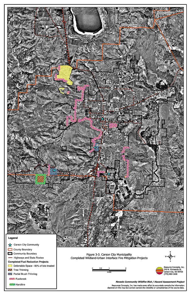
3.4 Previous Fire Hazard Reduction Projects
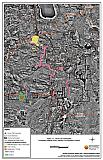
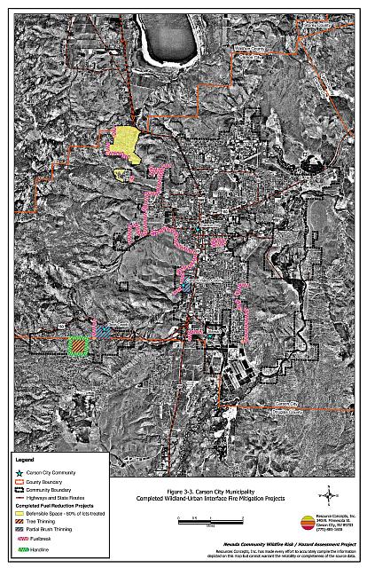
The Carson City Fire Department, US Forest Service Carson Ranger District, Bureau of Land Management Carson City Field Office, Nevada Division of Forestry, Clear Creek chapter of the Nevada Fire Safe Council, and the Washoe Tribe of Nevada and California have implemented several fuel hazard reduction projects for the wildland-urban interface areas of the Carson City Municipality (Figure 3-3). Additional projects have been planned in the Carson City, Carson Indian Colony, Clear Creek, and Stewart communities. Information on these projects is included in each community section.
Figure 3-1Community and Land Ownership, Carson City Consolidated Municipality |
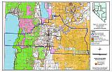 |
Figure 3-2Fire History, and Critical Features Potentially At-Risk, Carson City Consolidated Municipality |
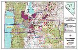 |
Figure 3-3Carson City Municipality Completed Wildland-Urban Interface Fire Mitigation Projects |
 |