![]()
![]()
3.0 Description Of The County
3.1 Demographics, Location, Topography, And Climatic Data
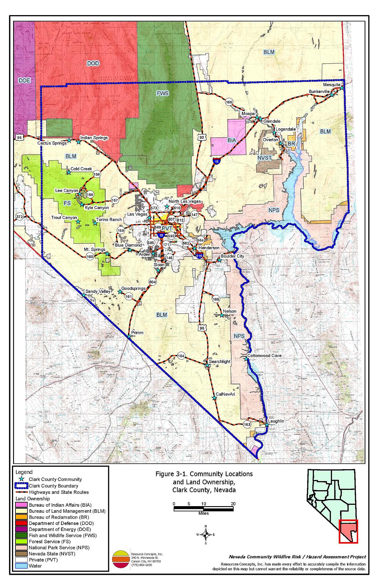
Clark County is located in southern Nevada and is approximately 7,910 square miles (over five million acres) in size. A summary of land administration and/or management is provided in Table 3-1.
| Land Administrator | Acres | Percent of County |
|---|---|---|
| Federal | ||
| Bureau of Land Management | 2,811,500 | 56 |
| US Fish and Wildlife Service | 496,700 | 10 |
| National Park Service | 454,300 | 9 |
| USFWS/Nellis Range | 355,600 | 7 |
| US Forest Service | 276,800 | 5 |
| US Air Force | 28,300 | <1 |
| State of Nevada | ||
| NDOW, NDOT, State Parks | 46,400 | 1 |
| Private / Local Government | ||
| Boulder City Easement, Private | 507,200 | 10 |
| Native American | ||
| Moapa River Indian Reservation | 71,500 | 1 |
| Las Vegas Paiute Indian Reservation | 3,900 | <1 |
| Fort Mojave Indian Reservation | 3,700 | <1 |
| Total | 5,055,900 | |
| Source: Clark County Multi-Species Habitat Conservation Plan (MSHCP) (Recon 2000). | ||
The population in Clark County was estimated to be 1,620,748 persons in 2003 (Nevada State Demographer’s Office). The Clark County economy is based primarily on tourism. Approximately 24 percent of the jobs are in hotels and gaming, nineteen percent are in retail trade, eleven percent are in government, nine percent are in construction, and 21 percent are in “other services” (www.co.clark.nv.us).
Elevations within the county range from 450 feet above mean sea level at the Colorado River to 11,918 feet at Charleston Peak in the Spring Mountains. The largest mountain ranges in Clark County include the Spring Mountains, the Sheep Range, the McCullough Range, and the Virgin Mountains. The largest valleys are Las Vegas Valley, Sandy Valley, Moapa Valley and the Virgin Valley. The climate is generally characterized by low precipitation and low humidity.
3.2 Wildfire History
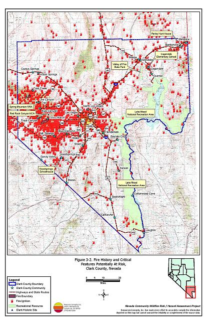
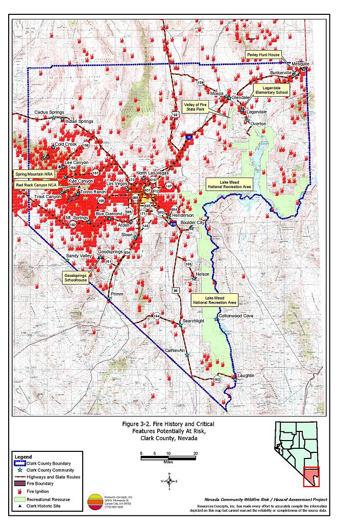
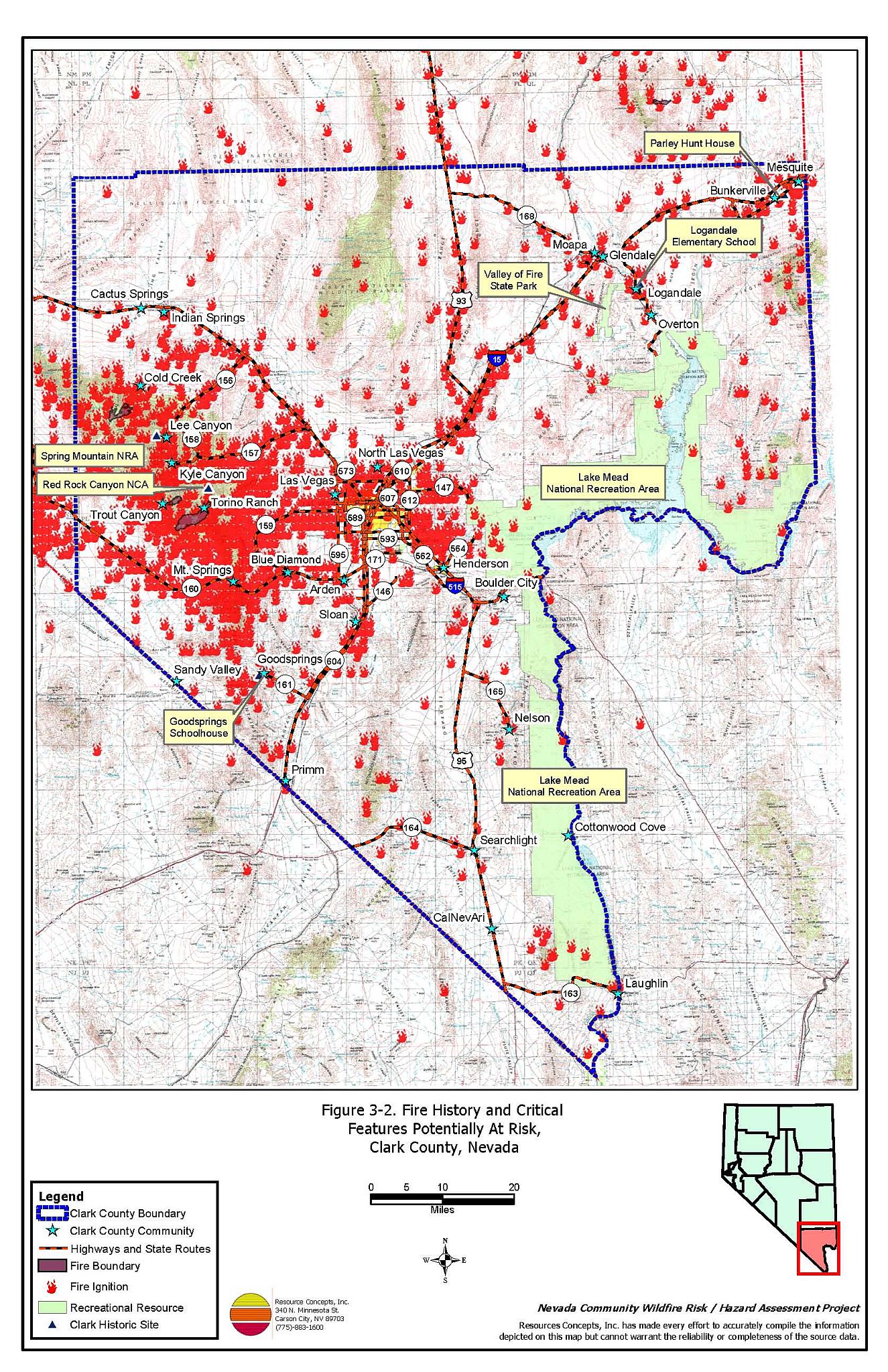
Wildfire history for Clark County was compiled from the Nevada Bureau of Land Management State Office database and the US Forest Service Las Vegas Field Office. Vegetation over the majority of the county is Mojave Desert scrub, which is typically too sparse to sustain large wildfires. When wildfires do occur in these areas, they tend to occur in dense stands of fuels such as palm forests, or along ephemeral and perennial drainages and irrigation ditches. Large wildfires are typically limited to the Spring Mountain Range in northwest Clark County, in the pinyon-juniper fuel type, where large fires have been known to occur every few years. Wildfire history in Clark County is detailed in Table 3-2 and illustrated in Figure 3-2.
| Year | Number of Fire Ignitions | Total Fire Acreage |
|---|---|---|
| Pre-1980 | 46 | 15,215 |
| 1980 | 115 | 9,288 |
| 1981 | 105 | 13,698 |
| 1982 | 149 | 7,444 |
| 1983 | 96 | 272 |
| 1984 | 91 | 301 |
| 1985 | 112 | 443 |
| 1986 | 112 | 166 |
| 1987 | 114 | 6,368 |
| 1988 | 91 | 770 |
| 1989 | 72 | 246 |
| 1990 | 75 | 15 |
| 1991 | 73 | 6 |
| 1992 | 53 | 16 |
| 1993 | 85 | 4,946 |
| 1994 | 57 | 8,261 |
| 1995 | 45 | 2,476 |
| 1996 | 49 | 3,072 |
| 1997 | 48 | 27 |
| 1998 | 67 | 571 |
| 1999 | 59 | 68 |
| 2000 | 67 | 8,737 |
| 2001 | 63 | 216 |
| 2002 | 49 | 4,307 |
| 2003 | 37 | 47 |
| TOTAL | 1,884 | 33,788 |
| Fire ignition and base acreage data provided by the National Interagency Fire Center, Boise, Idaho, Bureau of Land Management Nevada State Office, US Forest Service Humboldt-Toiyabe Supervisor’s Office, and the US Fish and Wildlife Service Nevada Fish and Wildlife Office. | ||
During the summer of 2004, a small fire was ignited in grass and brush along the roadside of State Route 158, when a vehicle went off the road. This ignition came to be known as the Robber’s Fire, which spread to a 290-acre wildfire that came within a mile and a half of residences in the Deer Creek neighborhood. This incident highlights the need to maintain highway roadsides free of flammable material in the Mt. Charleston area.
3.2.1 Ignition Risk Factors
Wildfire ignition risks fall into two categories: lightning and human caused. Human caused ignitions can come from a variety of sources such as burning material thrown out of vehicle windows, auto accidents, off-road vehicles, railroads, arcing power lines, agricultural fires, campfires, debris burning in piles or burn barrels, lit matches, and fireworks. The ignition source records for Clark County indicate that between 1981 and 2002, 579 wildfire ignitions were attributed to lightning and 976 were human caused.
3.2.2 Fire Ecology
The science of fire ecology is the study of how fire contributes to plant community structure and species composition. A “fire regime” is defined in terms of the average number of years between fires under natural conditions (fire frequency) and the amount of dominant vegetation replacement (fire severity). Natural fire regimes have been affected throughout most of Nevada by twentieth century fire suppression policies. Areas that formerly burned with high frequency but low intensity (fires more amenable to control and suppression) are now characterized by large accumulations of unburned fuels, which once ignited, will burn at higher intensities.
Frequent, low intensity wildfires characterize the natural fire regime in ponderosa pine forests. Under a native fire regime, frequent low-intensity surface fires reduce fuel loading from grasses and shrubs, suppress regeneration of shade-tolerant white fir seedlings, and leave the adult pine trees unaffected, protected by thick, fire-resistant bark. With a natural occurrence of wildfire, ponderosa pine forests often have an open, “park-like” appearance with an understory of grass or low shrubs. Under these conditions, heavy fuel loading can occur in discrete areas, but their discontinuous nature reduces the likelihood that a fire will burn with enough intensity to affect the mature trees.
In the absence of frequent surface fires in ponderosa pine communities, vegetation growth is uncontrolled resulting in extremely hazardous fuel conditions. Accumulated dead-and-down woody fuels and the emergence of understory shrubs such as Gamble’s oak, mountain mahogany, rabbitbrush, manzanita, sagebrush, and young white fir trees create ladder fuels that can carry flames into the tree canopy and potentially provoke a catastrophic, stand-destroying crown fire.
The natural fire regime for pinyon pine woodlands is typified by stand-replacing, high intensity, “stand destroying” wildfires that completely remove the existing woodland community. The low frequency of fires in these plant communities is attributed to the long periods of time required for the vegetation to reestablish vertical and horizontal continuity in the fuels and accumulate fuel loadings conducive to the combustion of the entire fuel load during a wildfire occurrence.
Mojave desert plant communities common to Clark County such as creosote bush, white bursage, and blackbrush evolved with very low fire frequencies ranging between 35 and 100 years (Brown et al., 2000). Wide spaces between shrubs, low biomass production, and low ground cover contribute to the naturally low fire occurrence in these communities. Creosote bush and blackbrush are not fire-adapted species and are often subject to high mortality rates even in low intensity burns. Plant re-sprouting of creosote bush after a fire is limited and restricts shrub reestablishment after a burn. Blackbrush is also very limited in its ability to reestablish following a wildfire in a time frame relevant to land management.
The long interval for desert shrub and pinyon pine reestablishment following fire is conducive for invasion of aggressive, pioneering plants such as cheatgrass and red brome. Since the 1970’s the fire frequency in the Mojave Desert has increased dramatically and includes the occurrence of some large fires. This increase in fire frequency is often attributed to the expansion of red brome and cheatgrass. Both species can create continuous ground fuel conditions that can facilitate ignitions and the spread of fire from shrub to shrub, especially in wet years when annual plants respond with increased vegetation growth.
3.3 Natural Resources and Critical Features Potentially at Risk
Critical features at risk of loss during a wildfire event can be economic assets such as agricultural and industrial resources or cultural features, such as historic structures, archaeological sites, and recreation-based resources. Clark County contains several natural and cultural resource features that could be at risk during a wildland fire.
3.3.1 Historical Registers
There are 54 sites listed on the National Register of Historical Places (NRHP) for Clark County. Fourteen sites are listed on the Nevada State Register of Historical Places (NSRHP). The effects of fire on cultural and historical resources depend upon factors that vary from site to site. Some factors that determine the vulnerability of a historic site to damage by a wildland fire are its physical location with respect to the wildland-urban interface, adjacent fuel loading, terrain, site type, and type of cultural or historical materials present. Archeological sites and historic trails are not necessarily vulnerable to wildfire impacts, although rock art, ceramics, and rock artifacts can be completely or partially destroyed by extremely hot fires. Historic districts, historic buildings, and resources that lie in the wildland-urban interface that could be negatively impacted by wildfire are summarized by community in Table 3-3 and illustrated in Figure 3-2.
| Site Name | Location | Source Register |
|---|---|---|
| Parley Hunt House | Bunkerville | National Register of Historic Places |
| Goodsprings Schoolhouse | Goodsprings | National Register of Historic Places |
| Logandale Elementary School | Logandale | Nevada State Register of Historic Places |
3.3.2 Recreation
Clark County hosts diverse recreational resources. Table 3-4 lists the primary recreational areas and the managing agency. The effects of wildfire on these areas could include loss of life during a wildfire and loss of use after a wildfire.
| Recreational Area | Managing Agency |
|---|---|
| Lake Mead National Recreation Area | National Park Service |
| Spring Mountains National Recreation Area | US Forest Service |
| Floyd Lamb State Park | Nevada State Parks |
| Old Las Vegas Mormon Fort | Nevada State Parks |
| Spring Mountain Ranch State Park | Nevada State Parks |
| Valley of Fire State Park | Nevada State Parks |
| Red Rock Canyon NCA and Backcountry Byway | Bureau of Land Management |
| Bitter Springs Backcountry Byway | Bureau of Land Management |
| Gold Butte Backcountry Byway | Bureau of Land Management |
| Nellis Dunes/Sunrise Mountain | Bureau of Land Management |
| Logandale Trails | Bureau of Land Management |
| Desert National Wildlife Refuge Complex | US Fish and Wildlife Service |
| Source: Nevada Public Lands Recreation Opportunities, 2002 | |
3.3.3 Flora and Fauna
There are eight species listed as “threatened or endangered” under the Endangered Species Act with potential habitat in Clark County. An additional 21 species from the Nevada Natural Heritage Program “Sensitive Taxa” list are protected by state legislation (Nevada Natural Heritage Program database; last updated for Clark County 18 March 2004). These species are identified in Table 3-4. The Nevada Natural Heritage Program, the Nevada Division of Forestry, and the Nevada Department of Wildlife should be consulted regarding specific concerns and potential mitigation to minimize impacts to these species prior to implementing fuel reduction projects or the occurrence of a wildfire.
Details on these species and measures to protect them in Clark County are provided in the Clark County Multiple Species Habitat Conservation Plan (Recon, 2000). Any of these species can be negatively impacted either directly or indirectly by wildfire. Impacts could include loss of habitat, conversion of habitat type, or erosion and sedimentation. Noteworthy habitats include those associated with the Spring Mountains, riparian corridors along washes, creeks, and rivers, and the Mojave Desert scrub vegetation types.
| Scientific name | Common name | Legislation |
|---|---|---|
| Plants | ||
| Arctomecon californica | Las Vegas bearpoppy | NRS 527.260.300 |
| Astragalus geyeri var. triquetrus | Threecorner milkvetch | NRS 527.260.300 |
| Astragalus mohavensis var. hemigyrus | Mokiak milkvetch | NRS 527.260.300 |
| Cryptantha insolita | Las Vegas catseye | NRS 527.260.300 |
| Eriogonum viscidulum | Sticky buckwheat | NRS 527.260.300 |
| Opuntia whipplei var.multigeniculata | Blue Diamond cholla | NRS
527.260.300 NRS 527.060.120 |
| Fish | ||
| Crenichthys baileyi moapae | Moapa White River springfish | NRS 501 |
| Cyprinodon diabolis | Devil’s hole pupfish | ESA-Listed
Endangered NRS 501 |
| Empetrichthys latos latos | Pahrump poolfish | NRS 501 |
| Gila elegans | Bonytail chub | ESA-Listed
Endangered NRS 501 |
| Gilia seminuda | Virgin River chub | ESA-Listed
Endangered NRS 501 |
| Lepidomeda millispinis mollispinis | Virgin River spinedace | NRS 501 |
| Moapa coriacea | Moapa dace | ESA-Listed Endangered NRS 501 |
| Plagopterus argentissimus | Woundfin | NRS 501 |
| Rhinichthys osculus moapae | Moapa speckled dace | ESA-Listed
Endangered NRS 501 |
| Xyrauchen texanus | Razorback sucker | NRS 501 |
| Amphibians | ||
| Rana onca | Relict leopard frog | NRS 501 |
| Reptiles | ||
| Gopherus agassizii | Desert tortoise (Mojave population) | ESA-Listed
Threatened NRS 501 |
| Heloderma suspectum cinctum | Banded Gila monster | NRS 501 |
| Mammals | ||
| Euderma maculatum | Spotted bat | NRS 501 |
| Birds | ||
| Athene cunicularia hpugaea | Western burrowing owl | NRS 501 |
| Buteo regalis | Ferruginous hawk | NRS 501 |
| Coccyzus americanus occidentalis | Western yellow-billed Cukoo | NRS 501 |
| Empidonax trailii extimus | Southwestern willow flycatcher | ESA Listed Endangered NRS 501 |
| Falco peregrinus | Peregrine falcon | ESA
Listed Endangered NRS 501 |
| Ixobrychus exilis hesperis | Western least bittern | NRS 501 |
| Otus flammeolus | Flammulated owl | NRS 501 |
| Phainopepla nitens | Phainopepla | NRS 501 |
| Rallus longirostris yuanensis | Yuma clipper rail | ESA Listed Endangered NRS 501 |
3.4 Previous Fire hazard Reduction Projects
In January 2002, the Bureau of Land Management, the US Forest Service, the Nevada Division of Forestry, and the Clark County Fire Department completed a risk assessment and mitigation plan for the communities of Kyle and Lee Canyons in the Mount Charleston area (Firehouse Inc. 2002).ĀIn September of the same year, a Mount Charleston chapter of the Nevada Fire Safe Council was formed and currently serves the Kyle and Lee Canyon communities. The Mount Charleston chapter is currently promoting defensible space improvements and fuels reduction treatments on individual private lots in Kyle Canyon neighborhoods, working with private contractors as well as public agencies. Grants from the Nevada Fire Safe Council and the Nevada Division of Forestry as well as donations of time and equipment from local contractors have helped facilitate this work (D. Grismanauskas, pers. comm.).
Fuels reduction treatments in areas that pre-date this plan are in need of maintenance, as dense shrub vegetation has reestablished in the understory. A joint project between the Nevada Division of Forestry and the US Forest Service to maintain and extend a 3.5 mile shaded fuelbreak along the east side of the Rainbow subdivision is currently in progress. Nevada Division of Forestry anticipates extending fuelbreaks from Poppy Ridge to State Route 157 (S. Bittingham, pers. comm.).
In the fall of 2003, the Bureau of Land Management began work on the Mesquite fuels project. This project includes clearance of 100 to 250 acres of tamarisk forest each year over a ten-year period. Eventually 1,709 acres will be cleared and replaced with native species. This project is intended to reduce the threat of wildfire along ten miles of wildland-urban interface in the Mesquite and Bunkerville communities and to restore native vegetation to this section of the Virgin River floodplain.
In July of 2003 the US Fish and Wildlife Service announced that they would be issuing a contract for hazardous wildland fuels reduction on the Moapa Valley National Wildlife Refuge near the town of Moapa. It was expected that approximately 250 palm trees would be removed and others trimmed to reduce the hazard they present to the refuge and surrounding property. Funding for this contract was made available through the National Fire Plan.
Figure 3-1Community Locations and Land Ownership, Clark County, Nevada |
 |
Figure 3-2Fire History and Critical Features Potentially at Risk, Clark County, Nevada |
 |