![]()
![]()
16.0 Searchlight
16.1 Risk and Hazard Assessment
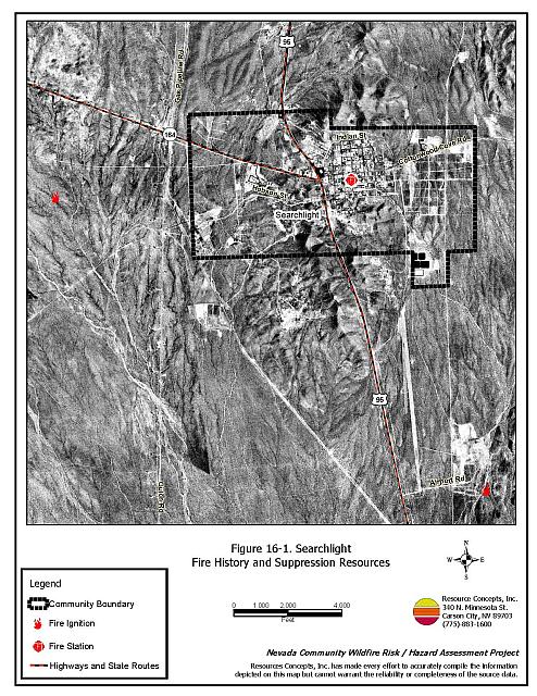
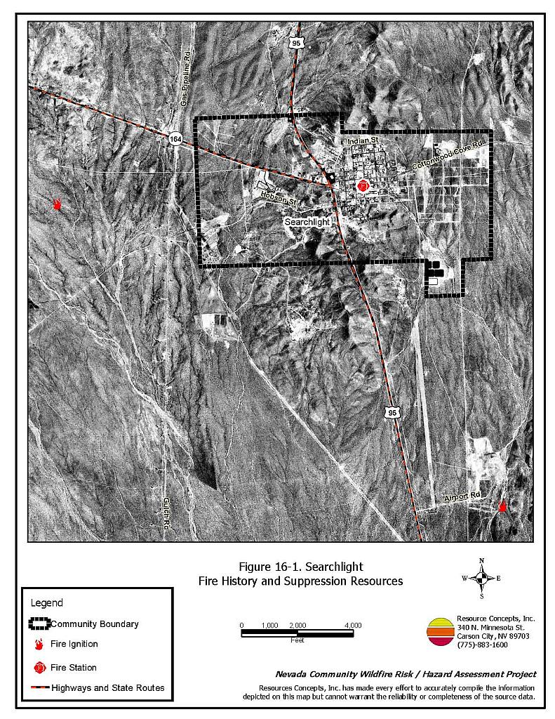
Searchlight is located at the south end of Clark County at the junction of Interstate 95 and State Route 164 approximately sixty miles south of Las Vegas. A total of 165 homes in the Searchlight area were observed during the community hazard assessment that resulted in classifying Searchlight in the Moderate Hazard category (48 points). The rating is primarily attributed to steep topography and limited fire protection resources. Table 16-3 at the end of this section presents a summary of the community hazard rating values for Searchlight.
16.1.1 Community Design
The urban interface condition surrounding Searchlight is classified as an intermix wildland-urban interface condition: structures are scattered throughout the wildland area with no clear line of demarcation between wildland fuels, buildings, and open space. The majority of the lots assessed are on parcels of less than one acre in size. The community boundary is shown in Figure 16-1.
- Access: Searchlight has several access roads. The primary roads are State Route 164 and Interstate 95. The road to Cottonwood Cove also runs through the community. The primary access roads are paved and more than 24 feet wide. The road grade is less than five percent. There are twenty secondary roads and five are dead-end streets without adequate turnaround space for fire suppression equipment to maneuver.
- Signage: Street signs are visible on all but two of the roads in the community. Residential addresses are visible on 75 percent of the homes in the community. Clear and visible street signs and residential addresses are important to aid firefighters in locating homes during low visibility conditions that occur during a wildland fire.
- Utilities: Overhead power lines and propane tanks in Searchlight pose a low ignition risk to the community.
16.1.2 Construction Materials
All of the homes in the interface are built with non-combustible roofing materials and approximately 82 percent of the homes have fire resistant siding materials. Approximately 29 percent of the homes in the community have unenclosed balconies, decks, porches, eaves, or attic vents that can create drafty areas where sparks and embers can be trapped, smolder, ignite, and rapidly spread fire to the house.
16.1.3 Defensible Space
Approximately three quarters of the homes within the Searchlight community met the defensible space landscaping requirement to minimize damage to the home or loss during a wildfire.
16.1.4 Suppression Capabilities
Wildfire Protection Resources
The Clark County Fire Department maintains Station 75 in Searchlight, an all-volunteer fire department that reported having twelve members at the time that interviews were conducted for this report. Additional County resources are dispatched through the Clark County Fire Alarm Office as needed. Suppression apparatus located onsite in Searchlight and available for initial attack are summarized in Table 16-1. Numbers quoted are based on data available at the time of interviews with local and regional fire authorities and are subject to change.
| Type of Resource | Amount of Equipment | Cooperating Partner (Resource Location) |
|---|---|---|
| Water Tender Type 1 Structure Engine Type 6 Quick Attack Engine Basic Life Support (BLS) Rescue |
1 1 1 1 |
Clark County Rural Fire Station 75 (Searchlight) |
| Water Tender Type 1 Structure Engine Type 6 Quick Attack Engine Basic Life Support (BLS) Rescue |
1 1 1 1 |
Clark County Rural Fire Station 84 (CalNevAri) |
| Type 3 Brush Engine | 1 | Boulder City Fire Department |
| Type 3 Brush Engine | 1 | Bureau of Land Management (Nearest Available) |
| Type 3 Brush Engine | 1 | National Park Service (Nearest Available) |
| Source: Steve McClintock, pers. comm., April 2004. | ||
The US Forest Service, the Bureau of Land Management, and the National Park Service provide mutual aid through the Las Vegas Interagency Communications Center. The Nevada Division of Forestry also provides mutual aid as dispatched through the Sierra Front Interagency Dispatch Center in Minden, Nevada. These systems locate the nearest available fire suppression resource according to incident command and computer aided dispatch protocols; it is important to note that Federal resources are commonly reassigned to areas of higher severity during the fire season.
Water Sources and Infrastructure
Water availability for fire suppression in Searchlight includes 500 GPM hydrants within 500 feet of the structures, community wells, and two one million gallon storage tanks. The water system operates on gravity.
Fire Protection Personnel Qualifications
Volunteer and career firefighters who would respond to a wildfire near Searchlight have a minimum of NFPA firefighter I and II training and a limited number have had some wildland firefighting training (National Wildfire Coordinating Group 310-1). The Nevada Division of Forestry and US Forest Service personnel meet minimum requirements per National Wildfire Coordinating Group 310-1.
Work Load
The Clark County Fire Department station responded to 274 emergency medical calls and one wildland brush fire calls in 2003.
Detection and Communication
Detection and communication is facilitated by 911 calls and the fire dispatch.
Financial Support
Funding for the Clark County Fire Department’s annual operating expenses comes from the County General Fund, which is generated primarily through property taxes.
Community Preparedness
Clark County has an active Local Emergency Planning Committee and has adopted an all-risk, multi-agency emergency plan. The plan is reviewed annually and updated as needed.
16.1.5 Factors Affecting Fire Behavior
The steepest slopes in the community are between ten and forty percent and face the southwest. These topographic conditions can intensify fire behavior. The vegetative fuel density in the Searchlight area is generally light throughout the community. Ground fuels consist of annual grasses. The shrub layer is dominated by bursage (one to two feet tall), creosote bush (four to six feet tall), and Joshua trees. Vegetation is widely spaced and the terrain is very rocky. The fuel hazard is considered low.
16.1.6 Fire Behavior Worst-Case Scenario
The worst-case scenario would occur on a summer afternoon during normal working hours when many volunteer firefighters may not be available for immediate response. An ignition source close to the south side of the community, with strong winds from the south would present the most hazardous conditions. Generally, fuels are sparse, but in a year with above normal annual grass growth, a fire could be pushed upslope and threaten structures.�
16.1.7 Ignition Risk Assessment
Searchlight has a low ignition risk rating. There is no significant wildfire history in the area surrounding the community, and the recorded history of lightning strikes and other ignitions shows no reported incidents.
16.2 Risk and Hazard Reduction Recommendations
Primary recommendations for Searchlight are to maintain defensible space and initiate community cleanup. These recommendations are detailed below.
16.2.1 Defensible Space
Vegetation density, type of fuel, and slope gradient around a home affect the potential fire exposure levels to the home. These conditions define the defensible space area required for individual homes. The goals of defensible space are to reduce the risk of property loss from wildfire by eliminating flammable vegetation near the home. In turn, this lowers the chances of a wildfire spreading onto adjacent properties and it aids firefighters in their efforts to protect property against an approaching wildfire. Guidelines for establishing and improving defensible space around residences and structures in the community are given below and described in greater detail in Appendix E.
Private Property Owners
- Remove, reduce, and replace vegetation around homes. Keep this area:
- Lean: There are only small amounts of flammable vegetation.
- Clean: There is no accumulation of dead vegetation or other flammable debris.
- Green: Existing plants are healthy and green during the fire season.
- Limb trees so that branches are at least fifteen feet away from chimneys, structures, and power lines. Limb trees to a height of four feet, but not more than one-third of the tree crown. Remove all dead and diseased branches and duff from beneath the remaining trees.
- Keep grass and weeds mowed to a maximum of three inches in height.
- Enclose wood decks and porches. If this is not possible, maintain the areas to be free of weeds and other flammable debris.
- Clear vegetation and combustible materials from around propane tanks for a minimum of ten feet.
- Immediately remove all cleared vegetation to an approved disposal site. This material dries quickly and poses a fire risk if left on site.
- Ensure that residential addresses are visible from the road. Address characters should be at least four inches high and reflective. Improving visibility of addresses will make it easier for those unfamiliar with the area to navigate during a wildland fire.
- Coordinate a general community clean-up effort and remove abandoned mobile homes.
- Install screens over attic vents to prevent sparks from entering the attic.
- Maintain defensible space annually.
- Have a back-up generator for pumping domestic wells or install gravity operated water storage tanks in the event that a fire eliminates power to the community.
Clark County Fire Department
- Conduct courtesy inspections of home defensible space measures.
16.2.2 Community Coordination
Coordination among local, state and federal fire suppression agencies is important in the day-to-day fire prevention activities and becomes critical in the event of a wildland fire. The goal of community coordination is to make the entire community fire safe.
Clark County Fire Department
- Allow burning only under a permit process or establish designated community burning days.
- Remove all abandoned wood structures.
16.2.3 Public Education
Public education is an important tool to engage public participation in making a community fire safe. Informed community members will take the initiative required to lead efforts of a scale sufficient to effectively reduce the threat that wildland fires present to the entire interface community.
Clark County Fire Department Recommendations
- Distribute copies of the publication “Living with Fire”to all property owners. This publication is free of charge. Copies can be requested from the University of Nevada Cooperative Extension.
16.2.4 Wildland Fire Training and Equipment
Clark County Fire Department
- Comply with minimum standards regarding training and personal protective equipment for all firefighters in accordance with the Wildland and Prescribed Fire Qualification System Guide PMS 310-1. (See Section 4.2 of this report for a description of these standards).
16.3 Summary of Recommendations
| Involved Party | Recommended Treatment | Recommendation Description |
|---|---|---|
| Property Owners | Defensible Space | Remove, reduce, and replace vegetation around homes according to the guidelines in Appendix E. Maintain defensible space as needed to keep the space lean, clean, and green. |
| Clark County Fire Department | Defensible Space | Conduct courtesy inspections of defensible space condition and defensible space treatments on private property. |
| Community Coordination | Allow burning only under a permit process or on designated community burn days. Remove all abandoned wood structures |
|
| Public Education | Distribute copies of “Living with Fire” to all property owners living in Lee Canyon. | |
| Training and Equipment | Comply with NWCG 310-1 training and equipment standards. |
Table 16-3. Searchlight Fire Hazard Ratings Summary |
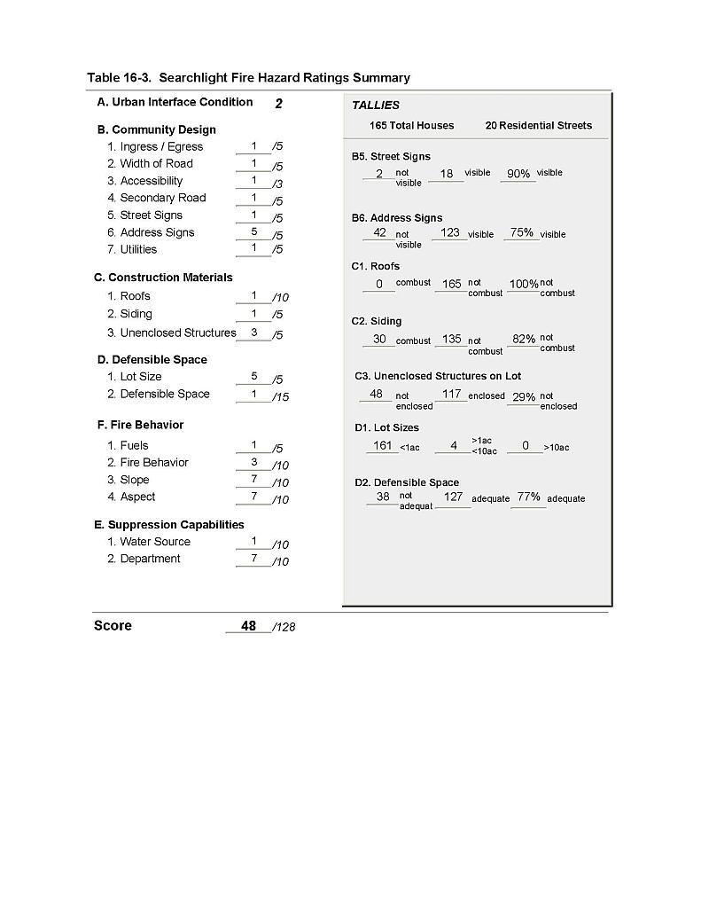 |
Figure 16-1 Searchlight Fire History and Suppression Resources |
 |