![]()
![]()
18.0 Blue Diamond
18.1 Risk and Hazard Assessment
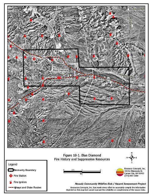
Blue Diamond is a small community located southwest of Las Vegas along State Routes 159 and 160 in southeastern Clark County. The town is situated in the Las Vegas Valley and is surrounded by undeveloped Mojave Desert scrub vegetation. The community hazard assessment resulted in classifying Blue Diamond in the Low Hazard category (36 points). This low score is attributed primarily to the sparse vegetation surrounding the community, the relatively flat terrain, and the fire safe construction of many of the structures in the interface area. A summary of the conditions that contributed to the hazard rating for Blue Diamond is included in Table 18-3 at the end of this section. The Blue Diamond community boundary is shown in Figure 18-1.
18.1.1 Community Design
The wildland-urban interface surrounding the community of Blue Diamond is an intermix condition. Structures are scattered throughout the wildland area with no clear line of demarcation between wildland fuels and the buildings and open space throughout the community. Eighty two percent of the homes are on parcels between one and ten acres in size; the remaining parcels are less than one acre.
Access: Blue Diamond is accessed by State Routes 159 and 160. Several streets lead into the community from these highways. Within Blue Diamond, roads are typically paved, greater than 24 feet in width, and have adequate room for fire suppression equipment to maneuver. All roads have less than a five percent gradient.
Signage: Street signs are present and visible along 95 percent of the streets. Residential addresses are visible on only one-third of the homes surveyed.
Utilities: All of the utilities were underground and do not pose an ignition risk to the community.
18.1.2 Construction Materials
Ninety-five percent of the homes observed in the interface area are built with fire resistant siding materials, and 98 percent were built with fire resistant roofing materials such as composition, metal, or tile. Twenty percent of the homes observed had unenclosed balconies, porches, decks, or other architectural features that create drafts and provide places where sparks and embers can be trapped, smolder, ignite, and rapidly spread fire to the home.
18.1.3 Defensible Space
Eighty-one percent of the homes have landscaping that meet the minimum requirement for defensible space to reduce the risk of property damage or loss of a home during a wildfire.
18.1.4 Suppression Capabilities
Wildfire Protection Resources
Clark County Rural Fire Station 80 in Blue Diamond is an all-volunteer fire department that reported having twelve members at the time interviews were conducted for this report. Additional County resources are dispatched through the Clark County Fire Alarm Office as needed. Resources that would respond to a reported wildland fire call near Blue Diamond are summarized in Table 18-1. Numbers quoted are based on data available at the time of interviews with local and regional fire authorities and are subject to change.
| Type of Resource | Amount of Equipment | Cooperating Partner (Resource Location) |
|---|---|---|
| Type 1 Engine Type 6 Quick Attack Engine Water Tender Advanced Life Support (ALS) Rescue |
1 2 2 1 |
Clark County Rural Fire Station 80 (Blue Diamond) |
| Source: Steve McClintock, Clark County Fire Rural Coordinator and Ken Moultray Volunteer Chief, Blue Diamond Volunteer Fire Station 3-04. | ||
Mutual aid can be requested from the US Forest Service, the National Park Service, and the Bureau of Land Management through the Las Vegas Interagency Communications Center. The Nevada Division of Forestry also provides mutual aid dispatched from the Sierra Front Interagency Dispatch Center in Minden, Nevada, which locates the nearest available fire suppression resource according to incident command and computer aided dispatch protocols. It is important to note that these resources can be assigned to other emergency incidents during the fire season.
Water Sources and Infrastructure
Water available for fire suppression in Blue Diamond includes 500 gpm fire hydrants within 500 feet of structures, wells, and two 100,000-gallon storage tanks. The water system is gravity operated.
Fire Protection Personnel Qualifications
Volunteer firefighters have a minimum of NFPA Firefighter I and II training and a limited number of volunteer firefighters have some wildland firefighting training (National Wildfire Coordinating Group 310-1).
Financial Support
Annual operating funds for the Clark County Fire Department comes from the County General Fund, which is generated through the collection of property taxes.
Community Preparedness
Clark County Fire Department has broad community preparedness and public education programs and reviews development plans to ensure compliance with the 1997 Fire Code. The Clark County Emergency Response Plan is updated annually.
The Blue Diamond Volunteer Fire Station holds an annual community awareness program to educate residents and promote defensible space.
18.1.5 Factors Affecting Fire Behavior
The terrain around the Blue Diamond community is mostly flat with slopes less than five percent. The vegetative fuel density in the interface area is light and consists primarily of annual grasses, greasewood, fourwing saltbush, and creosote bush. Greasewood and the fourwing saltbush shrubs are between two and three feet in height; creosote bush is four to five feet tall. There are a few mesquite trees in the area. Fuel density in this area was estimated to be less than one ton per acre and was considered a low fuel hazard. The predominant wind is from the south/southwest in the late afternoon.
18.1.6 Fire Behavior Worst-case Scenario
The worst-case scenario would occur on a mid-summer afternoon of a high precipitation year with maximum productivity of annual plants. An ignition upslope (west) of the upper Blue Diamond community could be pushed by strong winds through the ephemeral drainage channel and could potentially be driven toward the intersection of Highway 159 and 160.
18.1.7 Ignition Risk Assessment
Blue Diamond has a low ignition risk rating. There is no significant wildfire history on the public lands surrounding the community, although a light ignition history is reported in the area. Low ignition rates are facilitated in the low, sparse brush in and around the community.
18.2 Risk and Hazard Reduction Recommendations
The responsibility to keep a community fire safe falls not only on the local fire department but also on the residents of the community and local governments. The risk and hazard recommendations for Blue Diamond focus primarily on fuel reduction efforts.
18.2.1 Defensible Space Treatments
Defensible space treatments are an essential first line of defense for residential structures. The goal of the treatments is to significantly reduce or remove flammable vegetation within a prescribed distance from structures. (Refer to Appendix E for the recommended defensible space area). Defensible space reduces the fire intensity and improves firefighter and homeowner chances for successfully defending a structure against oncoming wildfire.
Property Owners
- Remove flammable vegetation and debris from within the defensible space area.
- Immediately dispose of cleared vegetation when implementing defensible space treatments. This material dries quickly and poses a fire risk if left on site.
- Maintain thisdefensible space as needed to keep the space lean, clean, and green.
- Maintain the areas underneath decks, porches, etc. free of weeds and other flammable debris to prevent sparks lodging, smoldering, and spreading fire to the home.
- Clear vegetation and combustible materials around propane tanks for a minimum of ten feet.
- Assure that residential addresses are visible from the road. Address characters should be at least four inches high, reflective, and posted where the road and driveway meet. Improving visibility of addresses will make it easier for those unfamiliar with the area to navigate under low visibility conditions during a wildland fire.
18.2.2 Community Coordination
Clark County
- Allow burning only under a permit process or on designated community burn days. See Appendix F for a sample burn permit.
- Facilitate cooperation between the Assessor’s Office and the Roads Department to ensure that all new development roads are named, mapped, and identified with GPS locations.
18.2.3 Fire Suppression Resources
Clark County Fire Department Blue Diamond Station
- Provide all firefighters with basic wildland fire training and equipment as described in the National Wildfire Coordinating Group (NWCG) Wildland and Prescribed Fire Qualification System Guide 310-1. Provide annual wildland firefighting refresher training and fire shelter training each year.
18.2.4 Public Education
Clark County Fire Department
- Distribute copies of the publication “Living With Fire” to all property owners. This publication is free of charge. Copies can be requested from the University of Nevada Cooperative Extension.
18.3 Summary of Recommendations
| Involved Party | Recommended Treatment |
Recommendation Description |
|---|---|---|
| Property Owners |
Defensible Space | Remove, reduce, and replace vegetation around homes according to the guidelines in Appendix E. Maintain defensible space as needed to keep the space lean, clean, and green. Assure that address signs are visible from the road. |
| Clark County | Community Coordination | Facilitate cooperation between the Assessor’s Office and the Roads Department to ensure that all roads in new residential developments are named, mapped, and identified with GPS locations. Allow burning only under a permit process or on designated community burn days. |
| Clark County Fire Department | Fire Suppression Resources | Provide all firefighters with basic wildland fire training and equipment and annual refresher courses. |
| Public Education | Distribute copies of the publication “Living With Fire”to all property owners. Request copies from the University of Nevada Cooperative Extension. |
Table 18-3. Blue Diamond Wildfire Hazard Rating Summary |
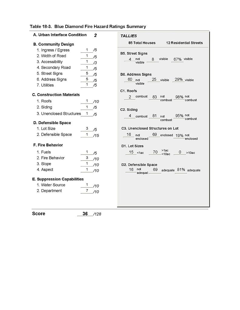 |
Figure 18-1 Blue Diamond Fire History and Suppression Resources |
 |