![]()
![]()
20.0 Bunkerville
20.1 Risk and Hazard Assessment
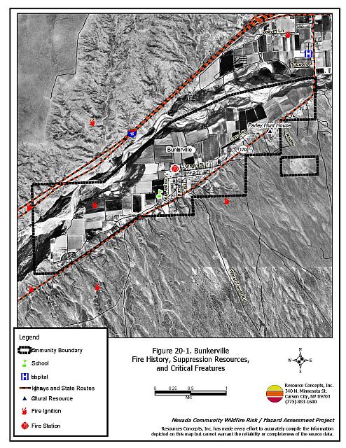
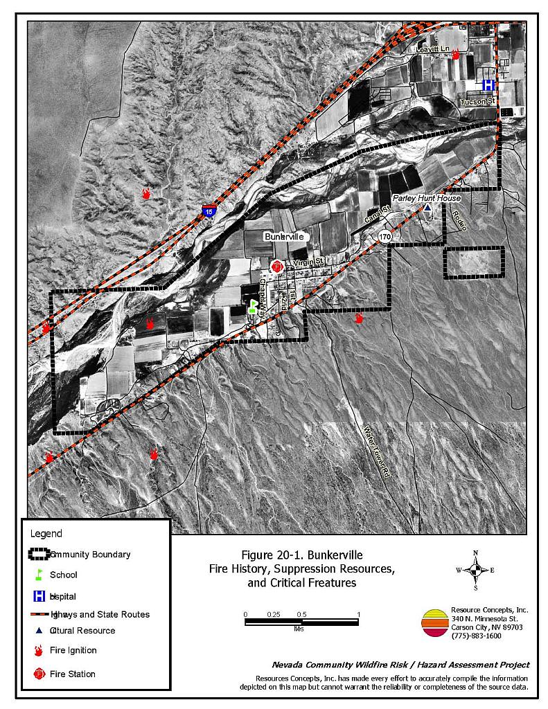
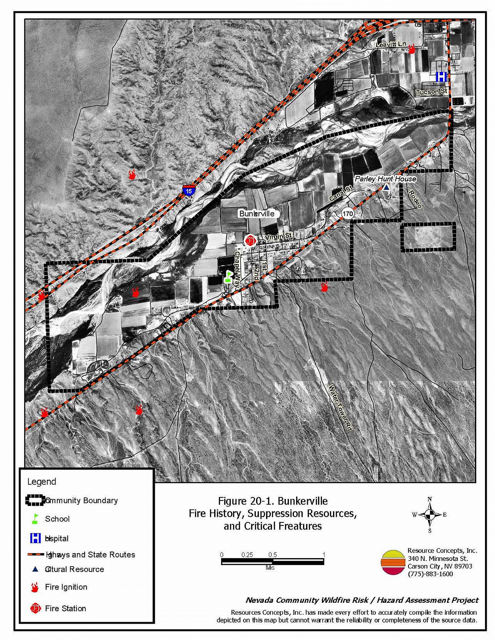
Bunkerville is located along the Virgin River in eastern Clark County approximately five miles west of the Arizona border and one mile south of Interstate 15. The community hazard assessment resulted in classifying Bunkerville in the Low Hazard category (38 points). The low rating is primarily attributed to good access, adequate defensible space, and fire resistant building materials. A summary of the conditions that contributed to the hazard rating for Bunkerville is included in Table 20-3 at the end of this section. The Bunkerville community boundary is shown in Figure 20-1.
20.1.1 Community Design
The area surrounding Bunkerville is characteristic of a classic wildland-urban interface condition, with a clear line of demarcation between building structures and wildland fuels. Wildland vegetation typically does not continue into the development areas. Most lots are on parcels of less than one acre in size.
- Access: Bunkerville is accessed via State Route 170 (Riverside Road), a paved two-lane road. Secondary roads provide adequate room for fire suppression equipment to maneuver.
- Signage: Street signs are visible on about 85 percent of the roads in the community. Residential addresses are visible on about eighty percent of the homes in the community.
- Utilities: Utilities are both above and below ground. The power line corridors are well maintained and pose a low ignition risk.
20.1.2 Construction Materials
Approximately 99 percent of the homes assessed in the interface are built with non-combustible roofing materials, and approximately 94 percent had fire resistant siding materials.
Over half of the homes in the community have unenclosed balconies, porches, decks or other architectural features that create drafts and provide areas where sparks and embers can be trapped, smolder, ignite, and rapidly spread fire to the home.
20.1.3 Defensible Space
The majority of the homes (91 percent) have landscaping that meets the minimum requirement for defensible space to reduce the risk of property damage or loss of a home during a wildfire.
20.1.4 Suppression Capabilities
Wildfire Protection Resources
Clark County Rural Fire Station 71 in Bunkerville provides fire protection for the community, with a thirteen member volunteer fire department. Additional county resources are dispatched through the Clark County Fire Alarm Office as needed. Fire protection equipment available for initial attack response is summarized in Table 20-1.
| Type of Resource | Amount of Equipment | Cooperating Partner (Resource Location) |
|---|---|---|
| Water Tender Type 1 Engine Type 6 Quick Attack Engine Advance Life Support (ALS) Rescue Basic Life Support (BLS) Rescue |
2 2 2 1 1 |
Clark County Rural Fire Station 71 (Bunkerville) CCFD Station 72 (Moapa) |
| Water Tender Type 1 Engine Type 6 Quick Attack Engine Advanced Life Support (ALS) Rescue |
2 2 2 2 |
Clark County Rural Fire Station 73 (Logandale) Clark County Rural Fire Station 74 (Overton) |
| Type 3 Brush Engine | 1 | Bureau of Land Management (Logandale Station) |
| Source: Steve McClintock, pers. comm., 3/2004, K. Oliver, 12 Oct. 04. | ||
Mutual aid can be requested from the US Forest Service and the Bureau of Land Management through the Las Vegas Interagency Communications Center. The Nevada Division of Forestry also provides mutual aid dispatched from the Sierra Front Interagency Dispatch Center in Minden, Nevada, which locates the nearest available fire suppression resource according to incident command and computer aided dispatch protocols. It is important to note that these resources can be assigned to other emergency incidents during the fire season. A mutual aid agreement is also in place with the City of Mesquite Fire and Rescue Department.
Water Sources and Infrastructure
Water available for fire suppression in Bunkerville includes fire hydrants within 500 feet of structures with a minimum 500-gpm flow capacity, community wells, and three one-million gallon tanks. The water system operates on gravity. The Virgin River and several ponds in the area could also be used for drafting or helicopter dip sites.
Fire Protection Personnel Qualifications
The firefighters have a minimum of NFPA Firefighter I and II training, and a limited number of volunteer firefighters have some wildland firefighting training (National Wildfire Coordinating Group 310-1).
Work Load
The Bunkerville Volunteer Fire Department responded to 118 emergency medical calls and sixteen wildland brush fire calls in 2003.
Financial Support
Annual operating funds for the Clark County Fire Department comes from the County General Fund, which is generated through the collection of property taxes.
Community Preparedness
Clark County has an active Local Emergency Planning Committee and has adopted an all-risk, multi-agency emergency plan. The plan is reviewed annually and updated as needed.
The Clark County Fire Department reviews development plans to ensure compliance with the UFC 1997 fire code. Effective January 2005, the State Fire Marshall’s Office adopted the 2003 International Fire Code, which includes an Urban-Wildland Interface Code that can be used as a guideline for new and existing developments.
20.1.5 Factors Affecting Fire Behavior
There are two vegetation types in the Bunkerville wildland-urban interface area: the Virgin River riparian corridor and the upland Mojave Desert scrub.
Fuel density in the Virgin River riparian corridor is heavily dominated by four to five foot tall fourwing saltbush and a tree layer consisting of tamarisk, mesquite, and willow that is eight to twelve feet tall. The fuel load was estimated at eight tons per acre and considered a high fuel hazard.
Upland areas surrounding the community have much lower fuel loads, estimated at less than one ton per acre. The dominant species are creosote bush, cholla cactus, and fourwing saltbush with annual grasses and Russian thistle in the disturbed areas along the roads. The fuel hazard in the uplands was considered low.
In the fall of 2003, the Bureau of Land Management began work on the "Mesquite Fuels Project." This ten-year project will clear 100 to 250 acres of tamarisk per year. Eventually 1,709 acres will be removed and replaced with native riparian species. This project will reduce the threat of fire within the river corridor.
20.1.6 Fire Behavior Worst-case Scenario
In a year with higher than normal precipitation and annual plant growth, an ignition on a mid-summer day with high wind conditions could be pushed toward the south end of the community.
20.1.7 Ignition Risk Assessment
Bunkerville has a low ignition risk rating. Prior fires in the area have been human caused and are most often started by ditch burning that escaped into heavy stands of tamarisk along the banks of the river. The ignition record for the area shows few incidents.
20.2 Risk and Hazard Reduction Recommendations
Risk and hazard reduction recommendations for Bunkerville focus on fuel reduction treatments.
20.2.1 Defensible Space Treatments
Defensible space treatments are an essential first line of defense for residential structures. The goal of the treatments is to significantly reduce or remove flammable vegetation within a prescribed distance from structures. (Refer to Appendix E for the recommended defensible space area). Defensible space reduces the fire intensity and improves firefighter and homeowner chances for successfully defending a structure against oncoming wildfire.
Property Owners
- Remove flammable vegetation and debris from within the defensible space area.
- Immediatelydispose of cleared vegetation when implementing defensible space treatments. This material dries quickly and poses a fire risk if left on site.
- Continue to maintainthis defensible space as needed to keep the space lean, clean, and green.
- Maintain the areas underneath decks, porches, etc. free of weeds and other flammable debris to prevent sparks lodging, smoldering, and spreading fire to the home.
- Clear vegetation and combustible materials around propane tanks for a minimum of ten feet.
- Assure that residential addresses are visible from the road. Address characters should be at least four inches high, reflective, and posted where the road and driveway meet. Improving visibility of addresses will make it easier for those unfamiliar with the area to navigate an area during a wildland fire.
20.2.2 Fuel Reduction Treatments
Bureau of Land Management
- Continue the tamarisk reduction project and reseed cleared areas with native species. Maintain these treated areas as needed.
Clark County
- Maintain vegetation clearance along road rights-of-way. The goal of fuel reduction treatment recommendations is to reduce the existing fuel hazard and the chance of wildfire.
20.2.3 Fire Suppression Resources and Training
Bunkerville Volunteer Fire Department
- Provide all firefighters with basic wildland fire training and equipment as described in the National Wildfire Coordinating Group (NWCG) Wildland and Prescribed Fire Qualification System Guide 310-1. Provide annual wildland firefighting refresher training and fire shelter training.
20.2.4 Public Education
Bunkerville Volunteer Fire Department
- Distribute copies of the publication “Living With Fire” to all property owners. This publication is free of charge. Copies can be requested from the University of Nevada Cooperative Extension.
20.3 Summary of Recommendations
| Involved Party | Recommended Treatment |
Recommendation Description |
|---|---|---|
| Property Owners |
Defensible Space | Continue to maintain defensible space around residences and outbuildings as needed to keep the space lean, clean, and green. Assure that residential addresses are visible from the road. |
| Bureau of Land Management | Fuels Reduction | Continue the tamarisk reduction and replacement project. |
| Clark County | Fuels Reduction | Maintain vegetation clearance along County road right-of-ways. |
| Clark County Fire Department | Fire Suppression Resources and Training | Provide all firefighters with basic wildland fire training and equipment. |
| Public Education | Distribute copies of the publication “Living With Fire” to all property owners. |
Table 20-3. Bunkerville Wildfire Hazard Rating Summary |
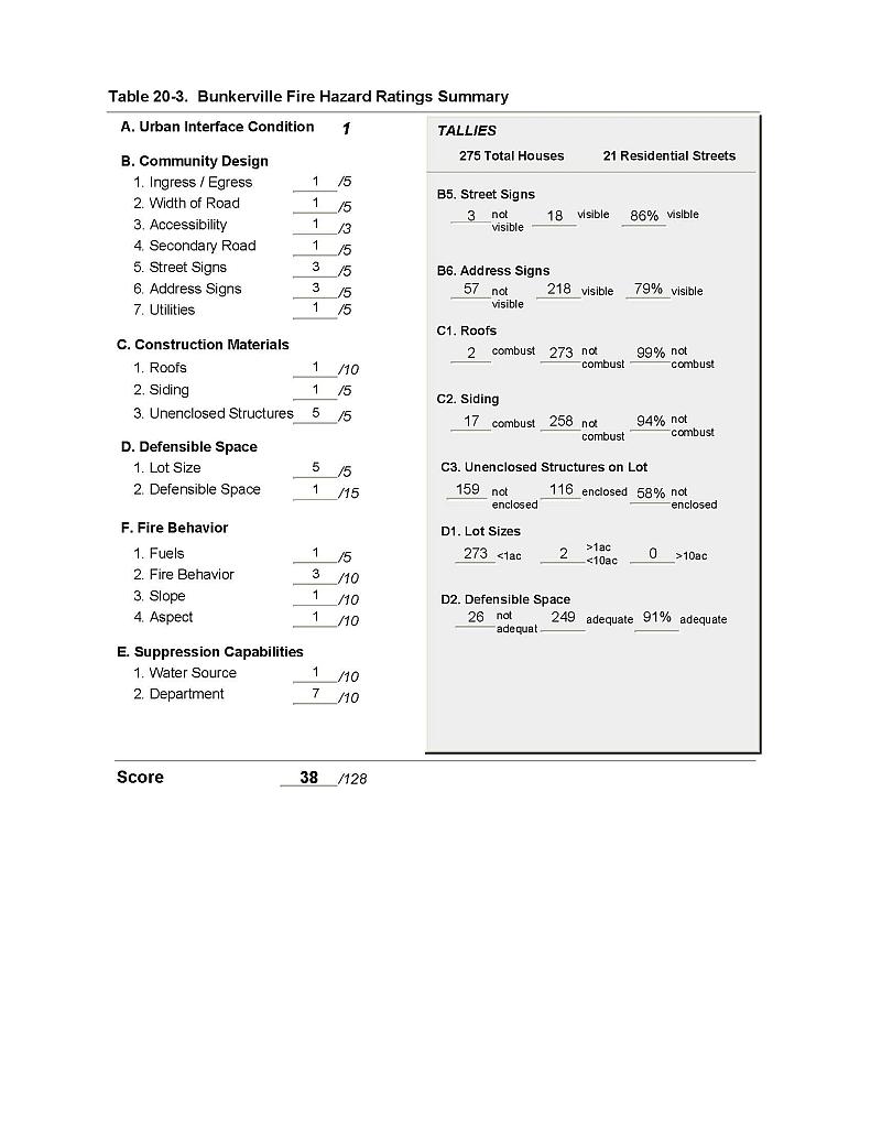 |
Figure 20-1 Bunkerville Fire History, Suppression Resources, and Critical Features |
 |