![]()
![]()
3.0 Description Of The County
3.1 Demographics, Location, Topography, and Climatic Data
Douglas County is located in western Nevada and is approximately 471,675 acres in size. A jurisdictional summary of land management and administration and coverage including water is provided in Table 3-1 and presented in Figure 3-1. Slightly more than half of land within Douglas County is administered and managed by federal agencies. The federal agency policies and decisions on lands located near the wildland-urban interface may have direct effects on private landowners within Douglas County.
| Land Administrator | Approximate Acreage | Percent of County |
|---|---|---|
| Bureau of Land Management | 161,622 | 34 |
| US Forest Service | 80,752 | 17 |
| State of Nevada | 727 | < 1 |
| Private* | 205,199 | 44 |
| Bureau of Indian Affairs | 3,647 | < 1 |
| Douglas County | 2,292 | < 1 |
| Water | 17,436 | 4 |
| Approximate values derived from the BLM land ownership GIS database and Douglas County Assessor’s Office. The land administrator for surface waters in Douglas County was not available in the database. * Includes Indian Allotment Lands. |
||
The county population was estimated to be 45,603 people in 2003 (Nevada State Demographer’s Office) The Douglas County economy is based primarily in services, trade, government, and agriculture. The Nevada Department of Employment, Training and Rehabilitation website lists the Douglas County School District, Bently Nevada Corporation, Douglas County, Wal-Mart Supercenter, and Carson Valley Inn as the largest employers in the Carson Valley portion of the county.
The majority of residential development in Douglas County is located either in Carson Valley or in the Lake Tahoe Basin. The scope of this report focuses on the developed areas in Carson Valley and south to Topaz Lake. The highest elevation within the county is 9,591 feet at East Peak. The lowest elevation is approximately 4,640 feet along the Carson River at the boundary between Douglas County and Carson City. The major valleys in Douglas County include Carson Valley, Long Valley, and Antelope Valley. Major mountain ranges and mountain features in Douglas County include the Carson Range, Pine Nut Mountains, Hot Springs Mountain, and the Wellington Hills.
3.2 Wildfire History
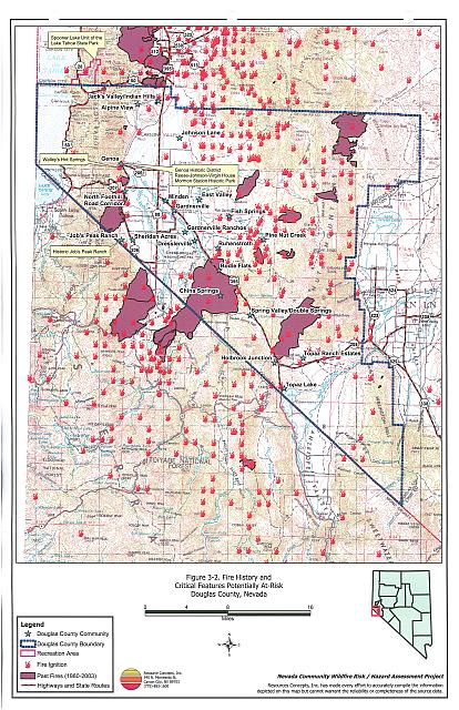
Several large wildfires have occurred in the recent history of Douglas County. Between 1980 and 2003, 48,005 acres (ten percent of Douglas County) burned in wildland fires. The largest fire recorded in the county was the 16,600-acre Indian Creek II Fire in 1984 that started in California and burned approximately 12,400-acres in Douglas County. Table 3-2 summarizes the large fire history and fire ignitions recorded by year for public lands within Douglas County. Figure 3-2 illustrates the recorded fire history in the vicinity of Douglas County. Several wildland fires have occurred on private lands within the county. Often these fires are not reported to federal agencies and are therefore, not reflected in Table 3-2 or Figure 3-2.
| Year | Number of Fire Ignitions | Total Fire Acreage |
|---|---|---|
| 1980 | 8 | NA |
| 1981 | 13 | 2,650 |
| 1982 | 6 | NA |
| 1983 | 11 | 2,163 |
| 1984 | 13 | 12,882 |
| 1985 | 8 | 10 |
| 1986 | 9 | 2 |
| 1987 | 19 | 61 |
| 1988 | 22 | 577 |
| 1989 | 4 | 55 |
| 1990 | 19 | 521 |
| 1991 | 10 | 2 |
| 1992 | 7 | 2 |
| 1993 | 3 | 2 |
| 1994 | 10 | 10,060 |
| 1995 | 2 | 0 |
| 1996 | 7 | 15,197 |
| 1997 | 4 | 18 |
| 1998 | 3 | <1 |
| 1999 | 14 | 89 |
| 2000 | 17 | 2,453 |
| 2001 | 10 | 445 |
| 2002 | 8 | 813 |
| 2003 | 9 | 3 |
| TOTAL | 236 | 48,005 |
| Source: Fire history data provided by the National Interagency Fire Center, Boise, Idaho. Fire acreage is derived from BLM and USFS fire perimeter data and specific to fire acreage within Douglas County. | ||
3.2.1 Ignition Risk Factors
Ignition risks for wildfires fall into two categories: lightning and human caused. Human caused ignitions can come from a variety of sources: fires started along highways and roads from burning material thrown out of vehicle windows or ignited during auto accidents, off-road vehicles, arcing power lines, agricultural fires, ditch burning, debris burning in piles or burn barrels, burning matches, target shooting, and fireworks. In the Douglas County database, records for 201 fire incidents include the ignition source; 162 were due to natural causes (lightning) and 39 were human caused.
3.2.2 Fire Ecology
The science of fire ecology is the study of how fire contributes to plant community structure and species composition. A “fire regime” is defined in terms of the average number of years between fires under natural conditions (fire frequency) and the amount of dominant species replacement (fire severity). Natural fire regimes have been affected throughout most of Nevada by twentieth century fire suppression policies. Large areas that formerly burned with high frequency but low intensity (fires more amenable to control, suppression, and rehabilitation) are now characterized by large accumulations of unburned fuels, which once ignited, will burn at higher intensities.
Some plant communities have evolved to burn frequently with low intensity, for example mature Jeffrey pine forests. Under a natural fire regime, low-intensity surface fires reduce fuel loading from grasses and shrubs, suppress regeneration of shade-tolerant white fir seedlings, and leave the adult Jeffrey pine trees unaffected, protected by thick, fire-resistant bark. Forests with frequent fire occurrence often have an open, “park-like” appearance with an understory of grass or low shrubs. Though shaded by large, mature trees, spacing between trees is sufficient to allow sunlight to reach the forest floor and encourage regeneration of shade-intolerant species like Jeffrey pine trees. Pockets of heavy fuels exist in these conditions, but their discontinuous nature reduces the likelihood that a fire will burn with enough intensity to negatively impact mature trees. In the absence of frequent surface fires, accumulated dead-and-down woody fuels and the green “ladder fuels” can carry flames into the coniferous overstory, potentially provoking a catastrophic, stand-destroying crown fire.
Big sagebrush communities are the most common vegetation types in Nevada with an altered fire regime, now characterized by infrequent, high-intensity, catastrophic fires. Sagebrush requires ten to twenty or more years to reestablish on burned areas, and most often these areas provide the conditions for establishment and spread of invasive species before sagebrush reestablishment can occur. Cheatgrass is the most common invasive species to reoccupy sagebrush and pinyon-juniper burned areas in northern Nevada.
Effect of Cheatgrass on Fire Ecology
Cheatgrass is a common, introduced annual grass that aggressively invades disturbed areas, especially burns. Replacement of a native shrub community with a pure stand of cheatgrass increases the susceptibility of an area to repeated wildfire ignitions, especially in late summer when desiccating winds and lightning activity are more prevalent. The annual production, or volume of cheatgrass fuel produced each year, is highly variable and dependent on winter and spring precipitation. Plants can range from only a few inches tall in a dry year to over two feet tall on the very same site in wet years. In a normal or above normal precipitation year, cheatgrass can be considered a high hazard fuel type. In dry years, cheatgrass is generally sparse and low in stature and poses a low fire behavior hazard because it tends to burn with a relatively low intensity. However, in both dry and wet years, dried cheatgrass creates a highly flammable fuel bed that is easily ignited with the propensity to rapidly burn into adjacent cover types that may be characterized by more severe and hazardous fire behavior. The ecologic risk of a fire spreading from a cheatgrass stand into adjacent, unburned native vegetation is that additional disturbed areas are thereby opened and vulnerable to cheatgrass invasion. Associated losses of natural resource values such as wildlife habitat, soil stability, and watershed functions are additional risks.
Eliminating cheatgrass is an arduous task. Mowing defensible space and fuelbreak areas annually before seed maturity is effective in reducing cheatgrass growth. In areas where livestock may be utilized, implementing early-season intensive grazing up to and during flowering may aid in depleting the seed bank and reduce the annual fuel load (BLM 2003, Davison and Smith 2000, Montana State University 2004). It may take years and intensive treatment efforts to control cheatgrass in a given area, but it is a desirable conservation objective in order to revert the landscape to the natural fire cycle and reduce the occurrence of large, catastrophic wildfires. Community-wide efforts in cooperation with county, state, and federal agencies are necessary for successful cheatgrass reduction treatments.
Fire Ecology in Pinyon-Juniper Woodlands
Singleleaf pinyon and Utah juniper are the dominant components of a plant community commonly referred to as Pinyon-Juniper (P-J). P-J woodlands were once characterized by a discontinuous distribution on the landscape and a heterogeneous internal fuel structure: a mosaic pattern of shrubs and trees resulting from the canopy openings created by small and frequent wildfires.
Both pinyon and juniper trees have relatively thin bark with continuous branching all the way to the ground. In dense stands, lower tree branches frequently intercept adjacent ladder fuels, e.g. shrubs, herbaceous groundcover, and smaller trees. This situation creates a dangerous fuel condition where ground fires can be carried into tree canopies, which often results in crown fires. A crown fire is the most perilous of all wildfire conditions and is usually catastrophic in nature since the danger to firefighters is generally too great to deploy ground crews.
3.3 Natural Resources and Critical Features Potentially at Risk
Critical features at risk of loss during a wildfire event can be economic assets such as agricultural and industrial resources, or cultural features such as historic structures, archaeological sites, and recreation-based resources.
3.3.1 Irrigation Water, Irrigation Systems, and Municipal Infrastructure
There are approximately twenty creeks (perennial, intermittent, or ephemeral) along the east slope of the Sierra Nevada that provide irrigation water to agricultural users and municipalities in Douglas County. A catastrophic fire along the eastern slope would substantially increase sediment yield and decrease water infiltration. The increased erosion and sedimentation would adversely impact the irrigation structures and create the need for extensive repair and maintenance on irrigation systems. In the absence of successful reclamation, decreased stream flow and groundwater recharge would reduce water yields. Additionally, mudslide hazards would be present until vegetation established in the burned areas, which would leave homes, roads, pipelines, and other municipal infrastructures at risk of loss.
3.3.2 Historical Registers
There are nineteen sites listed on the National Register of Historical Places for Douglas County. The Nevada State Register of Historical Places lists twelve sites. The effects of fire on cultural and historical resources depend on factors, which vary from place to place such as fuels, terrain, and type of cultural or historical materials present. Archeological sites and historic trails are not necessarily vulnerable to wildfire impacts. Historic districts, historic buildings, and resources that lie in the wildland-urban interface could be negatively impacted (damaged or destroyed) by wildfire are summarized in Table 3-3 and shown on Figure 3-2.
| Site Name | Location | Source Register |
|---|---|---|
| Genoa Historic District | Genoa | National Register of Historic Places; Nevada State Register of Historic Places |
| Job’s Peak Ranch | 144 Summit Ridge Way, Genoa | National Register of Historic Places |
| Reese-Johnson-Virgin House | 193 Genoa Lane Genoa | Nevada State Register of Historic Places |
| Walley’s Hot Springs | State Route 206, two miles south of Genoa. | Nevada State Register of Historic Places |
3.3.3 Recreation
The Spooner Lake Unit of the Lake Tahoe State Park is located within both Douglas County and the Carson City Municipality. The park is managed by the Carson-Tahoe Region Headquarters of the Nevada Division of State Parks. There are several structures within the 2,800-acre park unit including a maintenance building, well house, restroom, cross-country ski lodge, fee booth and entrance station, historic sheepherder’s cabin, water tender’s cabin, and two rental cabins. None of the structures are inhabited year-round, and all structures within the park are constructed of either wood siding or logs and have composite, asphalt, or metal roofs. No hydrants or water storage drafting sources are available for structure fire protection; however, water can be drafted out of nearby Spooner Lake.
Approximately 120,000 people visit the park annually and the estimated daily summer weekend visitation is 525 persons. The park management has developed an informal evacuation plan that they used to evacuate the Park during the 2004 Waterfall Fire. The Nevada Division of Forestry is the primary fire suppression agency responsible for the State Park. The Parks Division has received some funding for fuel reduction treatments along corridors outside of the Lake Tahoe Basin. They have also received funding from the Environmental Improvement Program for fuels reduction and forest health treatments for the areas of the park within the Lake Tahoe Basin (Kosch pers. comm.).
The Humboldt-Toiyabe National Forest, Carson Ranger District (USFS) has completed several fuels reduction treatments south of the Spooner Lake State Park. Approximately 400 acres were treated about ten years ago through a salvage timber sale and hand crew cut, pile, and burn treatments.
The Mormon Station State Historic Park is located in Genoa, Nevada and is the site of Nevada’s first non-native permanent settlement. The park hosts a replica of the original Mormon Station trading post and a small museum. There are also restroom facilities and areas for picnicking and group events. All structures within the Park have wood shake roofs and could be at risk of spot fires and building ignition if a wildfire occurred nearby.
3.3.4 Flora and Fauna
The Lahontan cutthroat trout is the only federally listed threatened species with potential habitat in Douglas County. Habitat for this trout could be severely impacted from accelerated erosion following a wildfire. Projects implemented to protect habitat for this species require formal consultation with the US Fish and Wildlife Service. An additional fifteen listed sensitive species are protected by Nevada State legislation and are identified in Table 3-4. The Nevada Natural Heritage Program, the Nevada Division of Forestry, and the Nevada Department of Wildlife should be consulted regarding specific concerns and potential mitigation to minimize impacts to these species when implementing fuel hazard reduction activities, prior to the event of a catastrophic wildfire.
| Scientific name | Common name | Legislation |
|---|---|---|
| Plants | ||
| Ivesia webberi | Webber ivesia | NRS 527.260.300 |
| Opuntia pulchella | Sand cholla | NRS 527.060.120 |
| Polyctenium williamsiae | Williams combleaf | NRS 527.260.300 |
| Rorippa subumbellata | Tahoe yellowcress | NRS 527.260.300 |
| Fish | ||
| Eremichthys across | Desert dace | NRS 527.260.300 |
| Oncorhynchus clarki henshawi | Lahontan cutthroat trout | ESA-Listed Threatened; NRS 527.260.300 |
| Mammals | ||
| Euderma maculatum | Spotted bat | NRS 501 |
| Lontra canadensis | River otter | NRS 501 |
| Martes americana | American marten | NRS 501 |
| Birds | ||
| Athene cunicularia ssp. Hypugaea | Western burrowing owl | NRS 501 |
| Buteo regalis | Ferruginous hawk | NRS 501 |
| Buteo swainsoni | Swainson’s hawk | NRS 501 |
| Falco peregrinus | Peregrine falcon | NRS 501 |
| Oreortyx pictus | Mountain quail | NRS 501 |
| Otus flammeolus | Flammulated owl | NRS 501 |
| Strix occidentalis ssp. Occidentalis | California spotted owl | NRS 501 |
3.4 Previous Fire Hazard Reduction Projects
The East Fork Fire and Paramedic Districts, US Forest Service Carson Ranger District, Nevada Division of Forestry, Spring Valley/Double Springs and Holbrook chapters of the Nevada Fire Safe Council, and the Washoe Tribe of Nevada and California have implemented several fuel hazard reduction projects in the wildland-urban interface areas of Douglas County. The Bureau of Land Management currently has a fuel reduction project in the Pine Nut Creek community underway that will be completed by May 2005. The Nevada Fire Safe Council has facilitated projects to complete risk assessments and develop recommendations for several fire mitigation projects throughout Douglas County. Information on completed, scheduled, and proposed hazard reduction projects is discussed further in each community section of this report.
Figure 3-1Community Locations and Land Ownership, Douglas County, Nevada |
 |
Figure 3-2Fire History and Critical Features Potentially at Risk, Douglas County, Nevada |
 |