![]()
![]()
15.0 Jacks Valley/Indian Hills
15.1 Hazard and Risk Assessment
The Jacks Valley/Indian Hills community is located in northern Douglas County east of Alpine View and north of Minden, Nevada. The community is situated on southeast-facing alluvial fans. Residential and commercial development is currently occurring in the community. The community is bordered by public lands to the northeast, by tribal lands to the northwest, by National Forest lands to the west, and by a golf course to the southeast. Approximately 500 homes were observed in the community during the assessment. The hazard assessment resulted in classifying Jacks Valley/Indian Hills in the Moderate Hazard category (43 points). A summary of the factors that determine this hazard rating is included in Table 15-2. The primary hazards for the Jacks Valley/Indian Hills community were the potential for hazardous fire behavior and small lot sizes (high density housing) in the interface areas.
15.1.1 Community Design
Jacks Valley/Indian Hills has the characteristics of both classic interface and intermix wildland-urban interface conditions. The classic interface is characterized by areas where subdivisions border wildland fuels with a clear line of demarcation between the fuels and the residences. Many lot sizes are primarily less than one acre in the newer subdivisions such as Sunridge. The intermix interface condition has structures scattered throughout the wildland area with no clear line of demarcation between wildland fuels and the lands and buildings of the community. In parts of the community characterized by the intermix condition the parcels are generally greater than one acre in size (see Figure 15-1).
- Roads: US Highway 395, Jacks Valley Road, Mica Drive, Plymouth Drive, and Hobo Hot Springs are the primary roads providing access between the various subdivisions in the Jacks Valley/Indian Hills community and other communities in Douglas County. The roads are paved, usually greater than 24 feet wide, and provide adequate access for fire suppression vehicles. Most of the secondary community roads have adequate turn around space for fire suppression equipment, and the majority of community roads have less than a five percent gradient.
- Signage: Street names were adequately identified with reflective letter signs. Residential addresses were visible on a majority of the homes assessed. Clear and visible residential addresses are important to aid firefighting personnel in locating homes during low visibility conditions that occur during a wildland fire.
- Utilities: Overhead power lines are present within the community. Power line right- of-ways were properly maintained, which minimizes the possibility of power lines sparking during windstorms and starting fires in nearby vegetation.
15.1.2 Construction Materials
Approximately nine percent of the homes assessed had wood shake roofing materials. The remainder of the homes assessed were built with fire resistant siding materials and non-combustible roofing materials, mainly composition type roofing. About eighteen percent of the homes observed have unenclosed balconies, porches, decks, or other architectural features that create drafts and provide areas where sparks and firebrands can be trapped, smolder, ignite, and rapidly spread fire to the home.
15.1.3 Defensible Space
A majority of the homes in the interface had landscaping that would meet the minimum defensible space requirement to help protect the home from damage or loss during a wildfire.
15.1.4 Suppression Capabilities
Wildfire Protection Resources
Jacks Valley/Indian Hills is provided wildland and structure fire protection by the East Fork Fire and Paramedic Districts Indian Hills Career-staffed Station 12 and the Jacks Valley Volunteer Fire Department Station 13. See Tables 4-2 and 4-3 for more information on the typical fire suppression response for first-alarm wildland-urban interface fires in Douglas County. Appendix E lists the type and number of fire suppression vehicles located at each EFFPD career staffed and VFD station.
Water Sources and Infrastructure
Water availability for fire suppression in Jacks Valley/Indian Hills includes one 50,000-gallon tank in Jacks Valley and two tanks with a total capacity of 1.5 million-gallons. There is an emergency generator for the pumps on the wells that fill the tanks. There are hydrants available throughout the Indian Hills portion of the community and hydrants available in some areas of the Jacks Valley community. However, the Jacks Valley hydrants do not meet the current fire code for flow capacity. The Carson River may be used as a helicopter dip site.
15.1.5 Factors Affecting Fire Behavior
Vegetation, dead and down fuels, and topographic features contribute to the potential fire hazard around wildland-urban interface communities. The terrain around Jacks Valley/Indian Hills is generally flat with southeast-facing slopes less than eight percent. The vegetative fuel density on the west side of the Jacks Valley/Indian Hills community is high, estimated at eight to ten tons per acre and consist primarily of big sagebrush, bitterbrush, and desert peach with a cheatgrass and bottlebrush squirreltail understory. Typical shrub heights range between four and eight feet.
Vegetation near Mica Drive is very similar to vegetation south and east of the Sunridge development. In both areas, vegetative fuels consist of big sagebrush, bitterbrush, and rabbitbrush with traces of crested wheatgrass, cheatgrass, and Russian thistle in the understory. Shrubs ranging in height from one to six feet are generally widely spaced (greater than eight feet). Fuel loads in these areas were estimated at two to three tons per acre and considered a low fuel hazard.
North of the Sunridge development on the east side of US Hwy 395, the vegetative fuels consist of big sagebrush, bitterbrush and rabbitbrush with an understory of needlegrass, cheatgrass, and bottlebrush squirreltail. The fuel load was estimated at three to six tons per acre and was considered a moderate fuel hazard.
Fire ignitions have occurred within the vicinity of the community from both human and lightning causes. An eighteen-acre fire occurred in the west portion of the community in 1989. Numerous small fires have occurred in the Jacks Valley Wildlife Management Area. The predominant wind direction is from the south/southwest, especially in the late afternoon.
15.1.6 Fire Hazard Reduction Projects
The USFS Humboldt-Toiyabe Carson Ranger District constructed a 200 to 400 foot wide fuelbreak along the north and northwest sides of the Jacks Valley/Indian Hills community. The Washoe Tribe of Nevada and California extended the treatment with a 25-foot wide fuelbreak from the USFS project to the north end of Summer Hill Street. The Jacks Valley VFD secured grants and constructed a 100 to 150-foot wide fuelbreak on the southwest side of the Jacks Valley/Indian Hills community. The Jacks Valley VFD has also been maintaining this fuelbreak.
The USFS Humboldt-Toiyabe Carson Ranger District is in the process of planning approximately 340 acres of fuel reduction treatment within the Jacks Valley Wildlife Management Area, located just west of the Jacks Valley/Indian Hills community. Proposed treatments include several 200-foot wide fuelbreaks along the National Forest boundary and along designated roads. Mechanical mastication equipment will likely be the primary method used to reduce fuels, except in areas where topography and ground conditions warrant the use of hand crews (see Figure 15-4). A final decision on implementation of this project is pending due to funding and prioritization by the Carson Ranger District.
15.1.7 Fire Behavior Worst Case Scenario
The worst-case scenario for Jacks Valley/Indian Hills would likely occur in the event of a lightning or human-caused ignition southwest of the community. With south or southwest winds exceeding 25 miles per hour, a fire could rapidly spread through the dense sagebrush and quickly threaten homes. Spot fires could expose numerous community structures to fire.
15.1.8 Ignition Risk Assessment
Jacks Valley/Indian Hills has been rated with a high ignition risk. Several fires and ignitions have occurred within and immediately adjacent to the community (Figure 15-1). The predominant ignition risks for Jacks Valley/Indian Hills are dry lightning and off-road-vehicle usage.
15.2 Risk and Hazard Reduction Recommendations
The Jacks Valley/Indian Hills risk and hazard reduction recommendations focus on improving defensible space and promoting homeowner responsibilities. Other recommendations pertain to community coordination efforts that could be initiated to enhance the fire safe nature of Jacks Valley/Indian Hills.
15.2.1 Defensible Space Treatments
Property Owner Recommendations
Defensible space treatments are an essential first line of defense for residential structures. Significantly reducing or removing vegetation within a prescribed distance from structures (minimum of 30 feet to 200 feet depending upon slope and vegetative fuel type) reduces fire intensity and improves firefighter and homeowner chances for successfully defending a structure against an oncoming wildfire.
- Remove, reduce, and replace vegetation around homes according to the guidelines in Appendix D. This area should be kept:
- Lean: There are only small amounts of flammable vegetation,
- Clean: There is no accumulation of dead vegetation or other flammable debris,
- Green: Existing plants are healthy and green during the fire season.
- Maintain the area beneath unenclosed wood decks and porches free of weeds and flammabledebris. Enclose these areas wherever possible.
- Mow or remove brush growing within a distance of 25 feet and grass within ten feet of wood fences in the community.
- Store firewood a minimum distance of thirty feet from structures.
- Install spark-arresting screens on chimneys.
- Irrigate all trees and large shrubs in close proximity to structures to increase their fire resiliency, which is especially important during drought conditions.
- Cheatgrass or other annual grasses that have become dominant within the defensible space zone should be mowed or treated with an application of pre-emergent herbicide prior to seed set. Treatments may need to be repeated the following year to ensure that the seed bank of unwanted grasses has been depleted. Refer to Appendix D for recommended seed mixes and planting guidelines that can be used in conjunction with removal of this annual grass.
- Immediately remove cleared vegetation to an approved disposal site when implementing defensible space treatments. This material dries quickly and presents a fire hazard if left on site.
- Maintain this defensible space as needed to keep the space lean, clean, and green.
15.2.2 Fuel Reduction Treatments
Fuel reduction treatments are applied on a larger scale than defensible space treatments. By permanently changing the fuel structure over large blocks of land to one of a lower volume or reduced flammability (a fuel reduction treatment), the expected result in the event of a catastrophic wildfire would be one of reduced capacity for uncontrolled spread through the treatment area.
Property Owner Recommendations
- Reduce vegetative fuels for a distance of ten feet on both sides of private driveways longer than 200 feet. Remove highly flammable shrub species and replace them with fire-resistant species such as crested wheatgrass, lawn, or a fire-resistant seeding. Appropriate seed mixtures and seeding specifications are provided in Appendix D.
- Coordinate with the US Forest Service and Washoe Tribe to construct and maintain existing and proposed fuelbreaks on the west side of the community.
US Forest Service and Washoe Tribe Recommendation
- Maintain existing fuelbreaks within the community every three to seven years as needed to maintain reduced fuel conditions (Figure 15-1).
US Forest Service Recommendations
- Construct and maintain a 100 to 200 foot wide fuelbreak for a distance of approximately one mile on the south side of Jacks Valley Road between the communities of Alpine View and Jacks Valley/Indian Hills. The total proposed treatment area is approximately 12 to 24 acres (see Figure 15-1). Remove all shrubs (except bitterbrush) and seed the fuelbreak with a seed mix suitable to the site such as the mix provided in Appendix D. The biomass generated from construction of the fuelbreak should be removed and disposed of at an appropriate site.
- Maintain existing fuelbreaks within the community every three to seven years or as necessary to maintain reduced fuel conditions.
- Construct and maintain the proposed 200-foot wide fuel reduction areas shown in Figure 15-2 and described in section 15.1.6.
Utility Company Recommendation
- Remove shrubs within fifteen feet of power poles and trim tree limbs within fifteen feet of power lines throughout the Jacks Valley/Indian Hills community.
15.2.3 Community Coordination
Many of the most effective activities aimed at reducing the threat of wildfire for the Jacks Valley/Indian Hills community require that individual property owners coordinate with each other and with local fire authorities. Defensible space, for example, is more effective in small communities when applied uniformly throughout entire neighborhoods. Public education and awareness, neighbors helping neighbors, and proactive individuals setting examples for others to follow are just a few of the approaches that will be necessary to meet the fire safe goals in the community. Disposal of biomass generated from defensible space and fuel reduction treatments can sometimes be most efficiently handled through community programs.
Property Owner Recommendations
- Assure addresses are visible from the road on all homes within the community. Address characters should be readily visible from the road, at least four inches tall and reflective.
- Reorganize the Alpine View/Jacks Valley chapter of the Nevada Fire Safe Council to include the Indian Hills and Sunridge areas.
East Fork Fire and Paramedic Districts and Nevada Division of Forestry Recommendation
- Distribute copies of the publication “Living With Fire” to all property owners who live in Jacks Valley/Indian Hills. This publication is free of charge. Copies can be requested from the University of Nevada Cooperative Extension.
15.3 Summary of Recommendations
| Involved Party | Recommended Treatment | Recommendation Description |
|---|---|---|
| Property Owners | Defensible Space | Remove, reduce, and replace vegetation around homes according to the defensible space guidelines in Appendix D. |
| Fuels Reduction | Reduce vegetative fuels for a distance of ten feet on both sides of private driveways longer than 200 feet. Coordinate with the US Forest Service and Washoe Tribe to construct and maintain existing and proposed fuelbreaks on the west side of the community. |
|
| Community Coordination | Assure that addresses are clearly visible from the road. Reorganize the local chapter of the Nevada Fire Safe Council to include the Indian Hills and Sunridge areas. |
|
| US Forest Service | Fuels Reduction | Construct and maintain a 100 to 200 foot wide fuelbreak for a distance of approximately one mile on the south side of Jacks Valley Road between the communities of Alpine View and Jacks Valley/Indian Hills. Coordinate with property owners to conduct maintenance every three to seven years on existing fuelbreaks near the community (Figure 15-1). Construct the proposed 200-foot wide fuel reduction areas shown in Figure 15-2. |
| Washoe Tribe | Fuels Reduction | Coordinate with property owners to conduct maintenance every three to seven years on existing fuelbreaks near the community (Figure 15-1). |
| Utility Company | Fuels Reduction | Remove trees or trim any branches within fifteen feet of either side of power lines and poles throughout the Jacks Valley/Indian Hills community. |
| East Fork Fire and Paramedic Districts Nevada Division of Forestry |
Community Coordination | Distribute copies of the publication “Living With Fire” to all property owners. |
Table 15-2Jacks Valley/Indian Hills Wildfire Hazard Rating Summary |
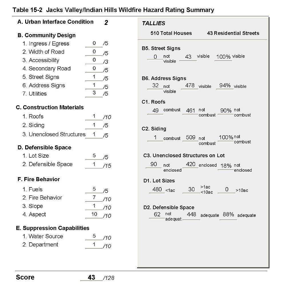 |
Figure 15-1Jacks Valley/Indian Hills Fire History, Suppression Resources, Critical Features, and Mitigation Projects |
 |
Figure 15-2Jacks Valley/Indian Hills USFS Proposed Mitigation Project |
 |