![]()
![]()
3.0 Description Of The County
3.1 Demographics, Location, Topography, and Climatic data
Elko County is located in northern Nevada, south of Idaho and east of Humboldt County, Nevada. Elko County is approximately eleven million acres in size. A jurisdictional summary of land management administration and coverage is provided in Table 3-1 and presented on Figure 3-1. The majority of land within Elko County is administered and managed by federal agencies. However there is a coordinated interagency effort throughout Elko County to wildfire response, risk reduction, and planning between the Bureau of Land Management, the US Forest Service, Nevada Division of Forestry, the Bureau of Indian Affairs, and local fire departments.
| Land Administrator | Approximate Acreage |
Percent of County |
|---|---|---|
| Federal | ||
| Bureau of Land Management | 6,900,000 | 63 |
| US Forest Service | 1,100,000 | 10 |
| Bureau of Indian Affairs | 160,000 | 1 |
| US Fish and Wildlife Service | 6,000 | < 1 |
| Department of Defense | 15,000 | < 1 |
| Private | ||
| 2,800,000 | 25 | |
| Other | ||
| 37,000 | < 1 | |
| Source: Approximate values from the Bureau of Land Management land ownership GIS database. | ||
In 2003 the population for Elko County was estimated at 45,805 persons (Nevada State Demographer). According to the Nevada Department of Employment, Training, and Rehabilitation, the primary employers in the County are trade industries, government, and service industries. The biggest employer in the County is the Elko County School District (Nevada Commission on Economic Development, 2004).
Elevations within the County range from 11,387 feet above sea level at Ruby Dome in the Ruby Mountains to about 4,265 feet south of West Wendover at the Wendover Air Force Range. There are many mountain ranges in Elko County including but not limited to the Adobe Range, Antelope Range, Bull Run Mountains, Cherry Creek Range, Dolly Varden Mountains, East Humboldt Range, Elko Hills, Goshute Mountains, Granite Range, Independence Mountains, Jarbidge Mountains, Medicine Range, Pequop Range, Pilot Range, Pinyon Range, Ruby Mountains, Snake Mountains, Spruce Mountain Ridge, Toano Range, Tuscarora Mountains, Windermere Hills, and Wood Hills. Some of the major valleys include Antelope Valley, Clover Valley, Goshute Valley, Huntington Valley, Independence Valley, Lamoille Valley, Pilot Creek Valley, Ruby Valley, Starr Valley, and Steptoe Valley. The Owyhee Desert lies in the northwestern portion of the County.
Climatic records for the past thirty years in Elko County show the average high/low temperatures range from 37°F/14°F in January to 89°F/48°F in July. Annual precipitation in Elko County is variable and averages 9.5 inches countywide. Precipitation in higher elevation communities such as Jarbidge reaches twenty inches or more each year (Western Regional Climate Center website). The majority of the precipitation received in Elko County arrives in the form of snow during the winter months with rain also occurring in the spring. The winter and early spring precipitation are most important for production of ground fuels that consist primarily of perennial and annual grasses. The summer and fall months are relatively dry with isolated thunderstorms providing the precipitation during these months. Dry lightning storms pose a high ignition risk to many communities in Elko County.
3.2 Wildfire History
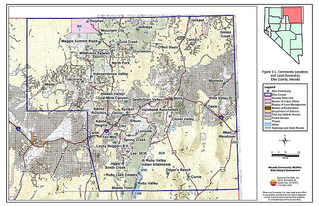
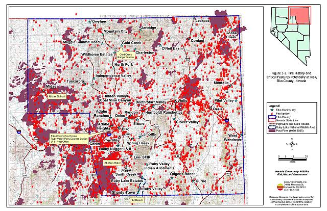
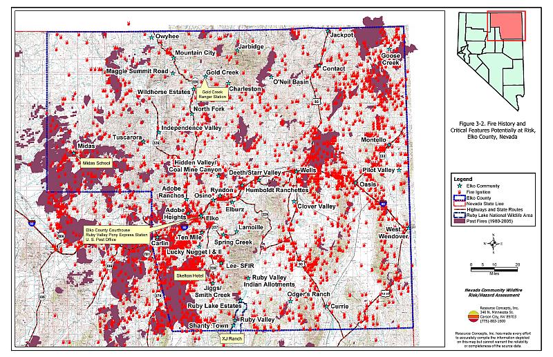
There is a consistent and dynamic record of wildland fire activity in Elko County (BLM Elko Field Office 2005). The fire records show that approximately fifteen percent of the County has burned since 1980. Table 3-2 summarizes the fire history and fire ignitions by year that have been reported in the database. Many additional small fires, especially lightning strikes have not been recorded. Figure 3-2 illustrates the large fire history and fire ignitions on a map of Elko County. The most extensive wildfires on record burned between 1999 and 2001.
| Year | Number of Fire Ignitions | Total Fire Acreage |
|---|---|---|
| 1980 | 42 | 5,669 |
| 1981 | 119 | 18,525 |
| 1982 | 34 | 1,035 |
| 1983 | 53 | 7,534 |
| 1984 | 84 | 74,563 |
| 1985 | 228 | 164,404 |
| 1986 | 132 | 16,228 |
| 1987 | 99 | 16,483 |
| 1988 | 98 | 22,820 |
| 1989 | 103 | 10,170 |
| 1990 | 90 | 18,541 |
| 1991 | 161 | 17,607 |
| 1992 | 126 | 21,423 |
| 1993 | 46 | 99 |
| 1994 | 110 | 56,659 |
| 1995 | 109 | 5,472 |
| 1996 | 144 | 87,247 |
| 1997 | 68 | 1,392 |
| 1998 | 84 | 14,753 |
| 1999 | 134 | 357,160 |
| 2000 | 148 | 303,160 |
| 2001 | 173 | 205,525 |
| 2002 | 64 | 11,176 |
| 2003 | 12 | 7,171 |
| 2004 | 2 | 921 |
| 2005 | 6 | 152,699 |
| TOTAL | 2,469 | 1,598,436 |
| Source: Fire history data provided by the National Interagency Fire Center, Boise, Idaho. Fire acreage is derived from Bureau of Land Management and US Forest Service fire perimeter data and is specific to acreage within Elko County. | ||
Fires that occur on private lands are often not included in the GIS datasets used to develop Table 3-2 and Figure 3-2. Where possible, this data has been included into the project database. Spring Creek, Lucky Nugget I & II, and Ten Mile were all noted to have had several fires that are not incorporated in the fire history databases. During interviews with local volunteer fire departments, the following fires were noted as missing from the databases and maps:
| Area and Fire Name | Acreage | Year |
|---|---|---|
| Ruby Valley | ||
| Battle Creek | 5,000 ac | 1994/1995 |
| Harrison Pass | 2,000 ac | 1999 |
| Dolly Creek | 2-3,000 ac | 1997 |
| Bald Mountain | 4,500 ac | 2004 |
| Midas | ||
| Buffalo complex | 100,000 ac | 2001 |
| Tuscarora | ||
| Snow Canyon | 60 ac | 2001 |
3.2.1 Ignition Risk Factors
Ignition risks for wildfires fall into two categories - lightning and human caused. Human caused ignitions can come from a variety of sources: fires started along roads from burning material thrown out of vehicle windows or ignited during auto accidents; off-road vehicles; railroads; arcing power lines; agricultural fires; ditch burning; debris burning in piles or burn barrels; target shooting; unattended campfires; and fireworks. In Elko County, railroads are the cause of many fires, especially from track maintenance work. The ignition source records for Elko County indicate that for the 2,469 ignitions reported, 1,571 were due to lightning (approx. 64 percent), 351 were human caused (approx. 14 percent), and the cause of 547 ignitions (approx. 22 percent) was not recorded.
3.2.2 Fire Ecology
The science of fire ecology is the study of how fire contributes to plant community structure and species composition. A “fire regime” is defined in terms of the average number of years between fires under natural conditions (fire frequency) and the extent to which dominant vegetation is replaced by fire (fire severity). Natural fire regimes have been affected throughout most of Nevada by twentieth century fire suppression policies. Large areas that formerly burned with high frequency but low intensity (fires more amenable to control and suppression) are now characterized by large accumulations of unburned fuels, which once ignited, will burn at higher intensities.
Big sagebrush is the most common plant community in Nevada with an altered fire regime, now characterized by infrequent, high-intensity fires. Sagebrush requires ten to twenty or more years to reestablish on burned areas. During the interim these areas can provide the conditions for establishment and spread of invasive species and in some cases inhibit sagebrush reestablishment. The most common invasive species to reoccupy burned areas in northern Nevada is cheatgrass.
Effect of Cheatgrass on Fire Ecology
Cheatgrass is a common introduced annual grass that aggressively invades disturbed areas, especially burns. Replacement of a native shrub community with a pure stand of cheatgrass increases the susceptibility of an area to repeated wildfire ignitions, especially in late summer when desiccating winds and lightning activity are more prevalent. The total height and volume of cheatgrass fuel produced each year is highly variable and dependent on winter and spring precipitation. In years with above normal precipitation cheatgrass will produce much higher volumes of highly flammable fuels and can fully occupy interspaces between shrubs. As the grass matures and dries, a continuous and receptive fuel bed is created that is capable of rapidly burning into adjacent cover types that may be characterized by more severe and hazardous fire behavior. The ecologic risk of a fire spreading from a cheatgrass stand into adjacent, unburned native vegetation is that additional disturbed areas are thereby opened and vulnerable to cheatgrass invasion. Associated losses of natural resource values such as wildlife habitat, soil stability, and watershed functions are additional consequences.
Eliminating, or at least controlling cheatgrass presents a difficult challenge. Mowing defensible space and fuelbreak areas each year before seed maturity is effective in the reduction of cheatgrass growth. In areas where livestock may be utilized, implementing early season intensive grazing up to and during flowering may aid in depleting the seed bank and reduce the annual fuel load (BLM 2003, Davison and Smith 2000, Montana State University 2004).[1] The use of pre-emergent herbicides has also proven effective in reducing growth and depleting the seed bank. Any herbicide treatment on public lands must be done in accordance with federal guidelines. Private landowners should proceed with caution if using herbicides,, should comply with all label instructions, and should consult their local extension specialist prior to use.
Fire Ecology in Pinyon-Juniper Woodlands
Single-leaf pinyon and Utah juniper are the dominant components of a plant community commonly referred to as pinyon-juniper (P-J). P-J woodlands were primarily confined to the steeper slopes commonly found at higher elevations in the Great Basin prior to European settlement. These woodland communities were characterized by a discontinuous distribution on the landscape and a heterogeneous internal fuel structure; a mosaic pattern of shrubs and trees resulting from the canopy openings created by small and frequent wildfires.
Both pinyon and juniper trees have relatively thin bark with continuous branching all the way to the ground. In denser stands, lower tree branches frequently intercept adjacent ladder fuels, e.g. shrubs, herbaceous groundcover, and smaller trees. This situation creates a dangerous fuel condition where ground fires can be carried into tree canopies and create crown fires. A crown fire is the most perilous of all wildfire conditions and is usually catastrophic in nature since the danger to firefighters is generally too great to deploy ground crews.
Over the last 100 years, wildfires in most of the western United States have been aggressively suppressed and P-J woodlands have encroached over areas traditionally occupied by other plant communities. Tree canopy coverage has been greatly expanded and has reached as high as sixty percent or more in some areas, contributing to the loss of diverse shrublands. These dense woodlands are perceived as being desirable for urban expansion in contrast to the surrounding deserts. In areas where human occupation in P-J woodlands has grown over the last fifty years, the option of returning to a natural fire regime becomes increasingly problematic.
3.3 Natural Resources and Critical Features Potentially At-Risk
Critical features at risk of loss during a wildfire event can natural resources, or can be economic assets such as agricultural and industrial resources, communication towers, or power poles. Cultural features such as historic structures, archaeological sites, and recreation-based resources can also be at risk.
3.3.1 Historical Registers
The potential for adverse effects to historic resources depends upon site-specific factors that vary one place to another such as the surrounding fuel hazard conditions, topography, and building materials. The majority of historic buildings that remain in Elko County’s historic mining communities, stage stops, and railway corridors are not formally listed in state or federal registers. Four sites listed on the Nevada State Register of Historical Places and additional unlisted resources that could potentially be damaged or lost by a wildfire in the wildland-urban interface are summarized in Table 3-3.
| Site Name | Location | Source Register |
|---|---|---|
| Henderson Bank Building | Elko | Nevada State Register of Historic Places |
| Metropolis Dam | 10.5 miles north of Wells | |
| Midas Schoolhouse | Midas | |
| Skelton Hotel | Jiggs | |
| Historic mining era buildings | Contact Midas Tuscarora |
BLM Elko Field Office |
| Stage stop, railroad depot, schoolhouse | Curry North Fork |
|
| Presbyterian church | Lamoille | |
| Ranch and school houses | Ruby/Clover Valley Deeth/Star Valley Montello |
3.3.2 Flora and Fauna
There are thirty species with potential habitat in Elko County that are listed as threatened or endangered under the Endangered Species Act or are otherwise protected by state legislation (Nevada Natural Heritage Program database; last updated for Elko County March 18, 2004). These species are identified in Table 3-4. The Nevada Natural Heritage Program, the Nevada Division of Forestry, and the Nevada Department of Wildlife should be consulted regarding specific concerns and potential mitigation to minimize impacts to these species prior to implementing fuel reduction projects and prior to the occurrence of a catastrophic wildfire. Project recommendations involving federally listed threatened of endangered species or their critical habitat require formal consultation with the US Fish and Wildlife Service.
| Scientific name | Common name | Legislation |
|---|---|---|
| Plants | ||
| Astragalus yoder-williamsii | Osgood Mountains milkvetch | NRS 527.260.300 |
| Eriogonum argophyllum | Sulpher Springs buckwheat | NRS 527.260.300 |
| Optunia pulchella | Sand cholla | NRS 527.060.120 |
| Fish | ||
| Gila bicolor isolata | Independence Valley tui chub | NRS 501 |
| Oncorhynchus clarki henshawi | Lahontan cutthroat trout | ESA-Listed Threatened NRS 501 |
| Oncorhynchus clarki utah | Bonneville cutthroat trout | NRS 501 |
| Oncorhynchus mykiss gairdneri | Inland Columbia Basin redband trout | NRS 501 |
| Relictus solitarius | Relict dace | NRS 501 |
| Rhinichthys osculus lethoporus | Independence Valley speckled dace | ESA-Listed Endangered NRS 501 |
| Rhinichthys osculus oligoporus | Clover Valley speckled dace | ESA-Listed Endangered NRS 501 |
| Salvelinus confluentus (population) | Bull trout (Jarbidge River basin population) | ESA-Listed Threatened NRS 501 |
| Mammals | ||
| Brachylagus idahoensis | Pygmy rabbit | NRS 501 |
| Euderma maculatum | Spotted bat | NRS 501 |
| Lontra Canadensis | River otter | NRS 501 |
| Birds | ||
| Accipiter gentilis | Northern goshawk | NRS 501 |
| Athene cunicularia hypugaea | Western burrowing owl | NRS 501 |
| Buteo regalis | Ferruginous hawk | NRS 501 |
| Buteo swainsoni | Swainson’s hawk | NRS 501 |
| Centrocercus urophasianus | Greater sage-grouse | NRS 501 |
| Charadrius alexandrinus nivosus | Western snowy plover | NRS 501 |
| Chlidonias niger | Black tern | NRS 501 |
| Coccyzus americanus occidentalis | Western yellow-billed cuckoo | NRS 501 |
| Cygnus buccinator | Trumpeter swan | NRS 501 |
| Falco peregrinus | Peregrine falcon | NRS 501 |
| Gavia immer | Common loon | NRS 501 |
| Haliaeetus leucocephalus | Bald eagle | ESA - Listed Threatened NRS 501 |
| Ixobrychus exilis hesperis | Western least bittern | NRS 501 |
| Oreortyx pictus | Mountain quail | NRS 501 |
| Otus flammeolus | Flammulated owl | NRS 501 |
| Plegadis chihi | White-faced ibis | NRS 501 |
3.3.3 Special Wildlife Areas
Nevada Department of Wildlife Gallagher Fish Hatchery
The Gallagher Fish Hatchery is situated on the western edge of the Ruby Marshes. The hatchery produces trout for stocking Nevada lakes and rivers, as well as producing eggs for other Nevada hatcheries. The fish hatchery is located on the eastern slope of the Ruby Mountains with several large canyons and drainages that open into the area. Slopes reach over thirty percent in some places. The higher slopes, previously covered by a pinyon-juniper woodland, burned in 1979. Recommendations to reduce wildfire hazards to the Gallagher Fish Hatchery are included in Chapter 32.
Ruby Lake National Wildlife Refuge
The refuge encompasses 39,928 acres and consists of a marsh bordered by meadows, grasslands, and brush-covered uplands. The refuge has been designated one of 500 Globally Important Bird Areas by the American Bird Conservancy. A wide variety of other wildlife inhabits the refuge including deer, antelope, and sage-grouse. A wildfire near the refuge would damage valuable habitat for these species Recommendations to reduce wildfire hazards to the Ruby Lake National Wildlife Refuge are included in Chapter 32.
3.3.4 Recreation
Large expanses of Elko County support outdoor recreation activity such as camping, hunting, fishing, hiking, wildlife viewing, and photography. Wildfires that affect the aesthetic values or wildlife habitat can indirectly affect local economies in Elko County.
3.3.5 Previously Completed Fuels Reduction and Hazard Mitigation Projects
The Bureau of Land Management Elko Field Office, US Forest Service Humboldt-Toiyabe Mountain City, Jarbidge, and Ruby Mountains Ranger Districts, and the Nevada Division of Forestry Northern Region coordinate to plan, propose, and implement fuel reduction and hazard mitigation projects throughout Elko County. Over the last two or three years, fuelbreaks and greenstrips have been constructed or are planned within the wildland-urban interface areas in the communities of Jarbidge, Lucky Nugget I & II, Midas, Mountain City, O’Neil Basin, Osino, Owyhee, Shanty Town, Spring Creek, Ten Mile, and Tuscarora. These projects are described more fully in each community’s section of this report.
3.4 Previously Completed Fuels Reduction and Hazard Mitigation Projects
The Bureau of Land Management Elko Field Office, US Forest Service Humboldt-Toiyabe Mountain City, Jarbidge, and Ruby Mountains Ranger Districts, and the Nevada Division of Forestry Northern Region coordinate to plan, propose, and implement fuel reduction and hazard mitigation projects throughout Elko County. Over the last two or three years, fuelbreaks and greenstrips have been constructed or are planned within the wildland-urban interface areas in the communities of Jarbidge, Lucky Nugget I & II, Midas, Mountain City, O’Neil Basin, Owyhee, Ryndon, Shanty Town, Spring Creek, Ten Mile, and Tuscarora. These projects are described more fully in each community’s section of this report.
Figure 3-1Community Locations and Land Ownership, Elko County, Nevada |
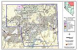 |
Figure 3-2Fire History and Critical Features Potentially At Risk, Elko County, Nevada |
 |