![]()
![]()
5.0 Jarbidge
5.1 Risk and Hazard Assessment
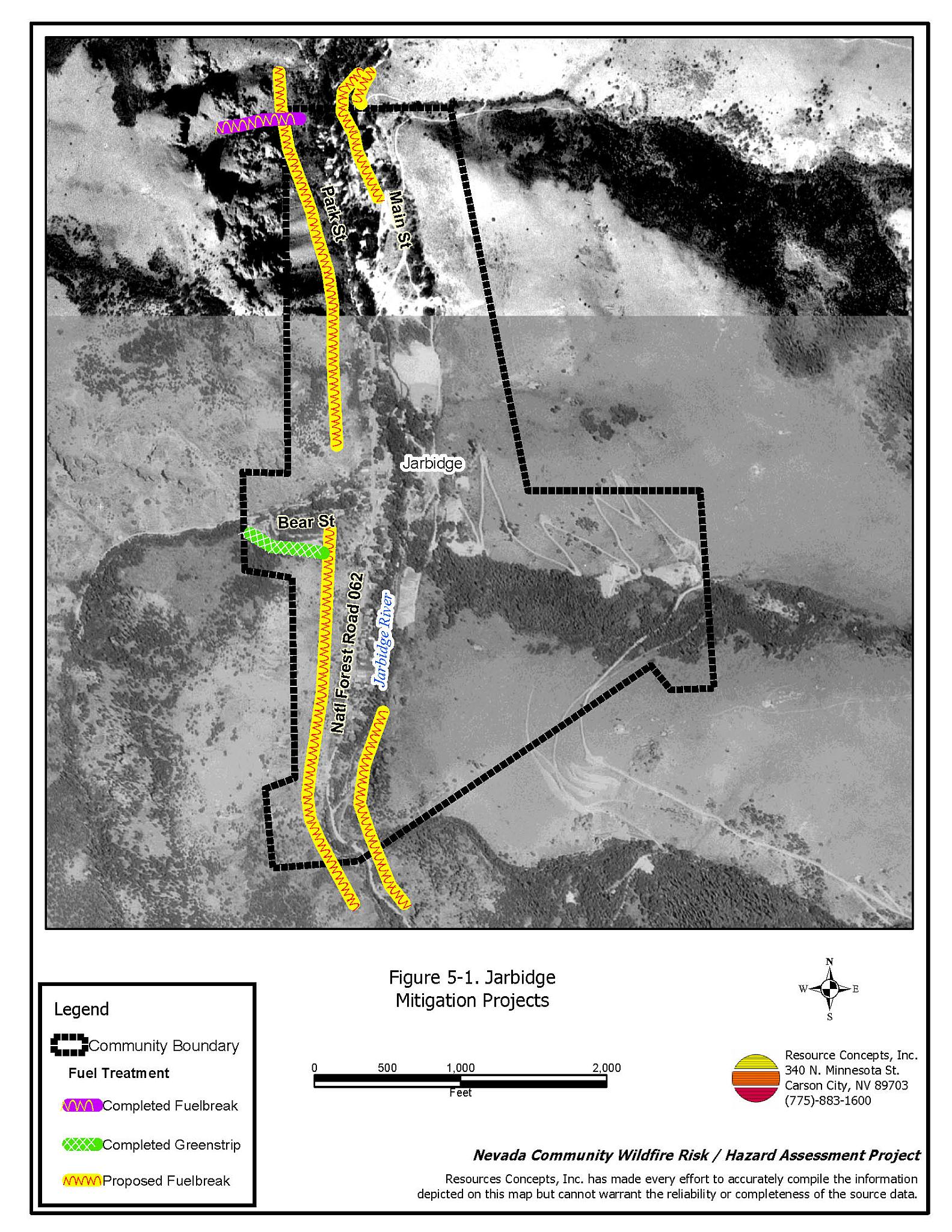
Jarbidge is located 100 miles north of Elko in northern Elko County. The town serves as the northern gateway to the Jarbidge Wilderness Area. Jarbidge is situated at an elevation of 6,200 feet. The community hazard assessment resulted in classifying Jarbidge in the Extreme Hazard category (85 points). A summary of the factors that contributed to the hazard rating is included in Table 5-3. The extreme rating is attributed to limited access, inadequate defensible space, and the potential for extreme fire behavior. The community boundary identified for this report is shown in Figure 5-1.
5.1.1 Community Design
The wildland-urban interface area around Jarbidge is an intermix condition. There is no clear line of demarcation between the structures and the wildland fuels along roads, back fences, etc. Therefore, fuels extend into the development area. All but one of the 76 homes included in this assessment are located on parcels less than one acres in size, and one home is on a lot that is one to ten acres in size.
- Access: Jarbidge is accessed via a series of dirt roads from the south in Nevada, or via the north through Idaho. The condition of the roads varies throughout the year. Accessibility within the community varies with some roads being too narrow to provide adequate space for fire suppression equipment to maneuver.
- Signage: Street signs are not clearly posted on any of the residential streets, and residential addresses are visible on only two homes in Jarbidge. Clear and visible street signs and residential addresses are important in locating homes during low visibility conditions that occur during a wildfire.
- Utilities: All of the utilities are above ground. The utility ignition risk hazard was considered moderate to high because the power lines are often blown down after large storms. Additional maintenance of vegetation under and adjacent to power lines is needed.
5.1.2 Construction Materials
Sixty-three percent of the homes observed in the interface area are built with non-combustible or highly fire resistant siding materials such as medium density fiberboard. Ninety-six percent of the homes have fire resistant roofing such as composition roofing, metal, or tile. Approximately one third of the homes have unenclosed porches, decks, or balconies that create drafts and provide areas where sparks and embers can be trapped, smolder, ignite, and rapidly spread fire to the house.
5.1.3 Defensible Space
Less than half of the homes observed meet the minimum recommended defensible space requirement to help protect the home from damage or loss during a wildfire.
5.1.4 Suppression Capabilities
Wildfire Protection Resources
Jarbidge is protected by the Jarbidge Volunteer Fire Department with additional support from the Jackpot Fire Department. The Jarbidge VFD has fifteen active members, with at least five responders at every fire incident. Table 5-1 lists the types of local wildfire resources and equipment available for initial response to Jarbidge in the event of a reported wildfire. Additional resources are available from local, state, and federal agencies through mutual aid agreements as described in Section 4.1.1.
| Type of Equipment | Amount of Equipment | Cooperating Partner (Resource Location) |
|---|---|---|
| Type 6 Engine Type 2 Engine |
1 1 |
Jarbidge VFD (Jarbidge) |
| Type 6 Engine | 1 | Nevada Division of Forestry (Seasonal patrol - weekends only) |
| Type 3 Engine Type 6 Engine |
1 1 |
Jackpot Fire Department (Jackpot) |
| Type 2 Engine Type 1 Water Tender |
1 1 |
Nevada Division of Forestry (Elko) |
| Type 6 Engine | 2 | US Forest Service (Mountain City and Wells Guard Stations) |
| Source: Sam Hicks, Nevada Division of Forestry Elko County Prevention Captain; Kenny Heil, Jarbidge VFD Chief; Tom Turk, Nevada Division of Forestry Northern Region Battalion Chief; Joe Freeland, Bureau of Land Management Elko Field Office FMO. | ||
Water Sources and Infrastructure
Water available for fire suppression resources in Jarbidge includes:
- Hydrants within 500 feet of structures with a minimum flow of 500 gallons per minute.
- Two water storage tanks totaling 315,000 gallons.
- Hose cabinets containing 1-1/2-inch nozzle and 250-foot 1-1/2-inch hose and hydrant wrenches are scattered throughout the community at intersections and along roads in front of homes.
The water system operates on gravity. The filtration system is capable of supplying 150 gpm of treated water directly out of Bear Creek.
Fire Protection Personnel Qualifications
All Jarbidge VFD firefighters have been trained in-house for structure protection and have received Nevada Division of Forestry Basic Wildland Firefighter training. The Jarbidge volunteers are trained to minimum National Wildfire Coordinating Group basic wildland standards.
Work Load
In a typical year the Jarbidge VFD responds to the following annual calls:
- Eight to ten emergency medical calls.
- Four to five wildland/brush fire calls.
- Ten to fifteen rescue calls.
Community Preparedness
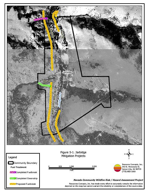
The Nevada Division of Forestry in conjunction with the Bureau of Land Management Elko Field Office and the US Forest Service completed a 200-foot wide shaded fuelbreak on the north side of Jarbidge and a 200-foot wide greenstrip along Bear Creek. The project was begun in 2001 and was completed in June of 2003. Brush was removed in the Bear Creek greenstrip using both mechanical mastication equipment and hand treatments (Figure 5-1).
5.1.5 Factors Affecting Fire Behavior
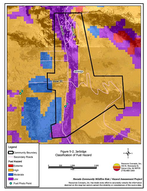
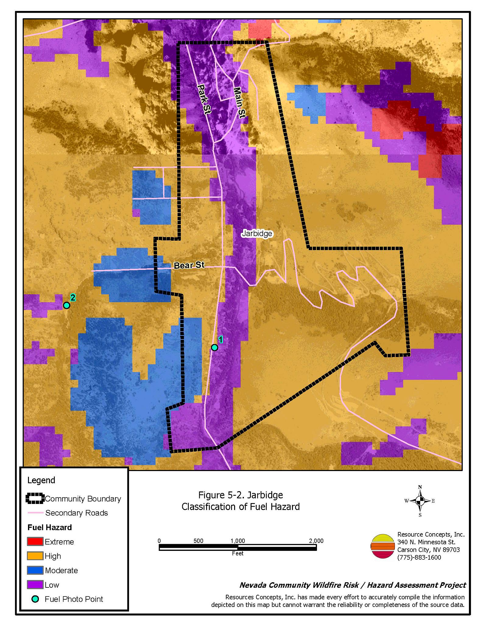
Fuels in the community vary with slope and aspect. West facing slopes have mountain mahogany, Rocky Mountain juniper, subalpine fir, and aspen trees with sagebrush, rabbitbrush, cheatgrass, and basin wildrye in the understory. The fuel loading was estimated at two to eight tons per acre and the fuel hazard for the west facing slopes varied from low to extreme on steep slopes. The east facing slopes have similar vegetation, but lack subalpine fir and aspen. Fuel loading was estimated at one to eight tons per acre on east facing slopes, and was considered a moderate to high fuel hazard. Figure 5-2 shows fuel hazard conditions in the interface area. Fuel hazard photos are shown in Figure 5-3.
Jarbidge is situated in the bottom of a rugged, steep north-south trending canyon. The sides of the canyon are vertical in some areas. The prevailing wind direction is from the south/southwest. There is a history of afternoon thunderstorms and dry lightning strikes in the area.
5.1.6 Fire Behavior Worst Case Scenario
The worst-case scenario for a wildfire in the area surrounding Jarbidge would come from a dry lightning storm in late afternoon in July or August during a year of normal to above normal precipitation and high annual grass and forb production. Multiple fire ignitions south of the community, strong erratic winds, and thunderstorms coupled with predominant south winds would push a fire down canyon into the community. Since additional fire resources are well over one hour away, fires could easily exceed initial attack capabilities of the local volunteer fire department. Fires starting to the north of Jarbidge could be drawn through the community by the chimney effect of the canyon.
5.1.7 Ignition Risk Assessment
Jarbidge has a moderate to high risk of ignition based on fire history in the area and the potential for increased fuel loading from annual grasses in high precipitation years. The primary risk of ignition in Jarbidge is lightning, although human caused ignitions are unpredictable and can occur at any time.
5.2 Risk and Hazard Reduction Recommendations
The responsibility to keep a community fire safe falls not only on the local fire protection district but also on the residents, businesses, and local governments. The recommendations for the Jarbidge area focus primarily on the ongoing and additional efforts to create and maintain defensible space and on community coordination and public education efforts that could be undertaken to enhance fire safety.
5.2.1 Defensible Space Treatments
Defensible space treatments are an essential first line of defense for residential structures. The goal of the treatments is to significantly reduce or remove flammable vegetation within a prescribed distance from structures. (Refer to Appendix E for the minimum recommended defensible space area). Defensible space reduces the fire intensity and improves firefighter and homeowner chances for successfully defending a structure against oncoming wildfire.
Property Owners Recommendations
- Remove, reduce, and replace vegetation around homes according to the guidelines in Appendix E. This area should be kept:
- Lean: There are only small amounts of flammable vegetation.
- Clean: There is no accumulation of dead vegetation or other flammable debris.
- Green: Existing plants are healthy and green during the fire season.
- Store woodpiles a minimum distance of thirty feet from any structure.
- Mow or remove brush growing against fences in the community. The minimum distance for clearance should be ten feet in grass and 25 feet in brush.
- Maintain areas under wood decks and porches free of weeds and other flammable debris. Enclose these areas when possible. Box in eves and cover attic and other ventilation openings with very fine metal wire mesh to prevent embers from entering the attic or crawl space.
- Remove pine needles, leaves, and debris from roofs and rain gutters.
- Replace wood shake roofs with fire resistant materials such as metal, tile, or composition.
- Clear all vegetation and combustible materials around propane tanks for a minimum distance of ten feet.
- Install spark arrestors on chimneys.
- Prune limbs from fir trees to a height of fifteen feet, but not more than one-third the height of the total tree height. Prune limbs from juniper trees to a minimum height of four feet from the ground, but not more than one-third the total tree height. Pruning should be completed to reduce ladder fuels on all deciduous and coniferous trees within the defensible space zone. Prune all dead and diseased branches.
- Prune all tree branches to a minimum distance of fifteen feet from buildings, paying special attention around chimneys.
- Immediately dispose of cleared vegetation when implementing defensible space treatments. This material dries quickly and poses a fire hazard if left on site.
- Maintain the defensible space as needed.
- Remove all dead vegetation and other flammable materials minimum of five feet from the exterior of the structure.
- Consider the purchase of fire suppression products such as fire blocking gels or foams that can be applied to structures and vegetation to create an added layer of flame resistance in the event of a fire.
5.2.2 Fuel Reduction Treatments
Fuel reduction treatments are applied on a larger scale than defensible space treatments. Permanently changing the fuel characteristics over large blocks of land to one of a lower volume and one of altered distribution reduces the risk of a catastrophic wildfire in the treated area. Reducing vegetation along roadways and driveways could reduce the likelihood of blocking access and escape routes, help contain the fire perimeter, and improve firefighter access and safety for protecting homes.
Utility Company
- Reduce and remove vegetation to maintain clearance around power lines. Clear vegetation within fifteen feet of utility poles near the community. Remove all trees from beneath power lines. Reduce and remove vegetation to maintain a minimum clearance of thirty feet from fences around power substations.
Nevada Division of Forestry and US Forest Service
- Construct a shaded fuelbreak along both sides of the main road for a distance of one mile above and below the community. The fuelbreak should be 300 feet wide as shown in Figure 5-1.
Elko County
- Remove all trees from the edge of the roads to increase accessibility during a fire, reduce the flame lengths, and reduce the chances of spotting across the roads.
5.2.3 Fire Suppression Resources
Nevada Division of Forestry
- Work with the Jarbidge community to find seasonal staffing for firefighter coverage seven days-per-week.
- Station a Type 2 water tender at the Jarbidge Volunteer Fire Station during the fire season.
- If available, move additional resources into the area or ensure adequate volunteer resources for high hazard days.
5.2.4 Community Coordination
Property Owners
- Form a local community-based organization to take responsibility and provide leadership for community-wide fuels reduction and community fire safety. The Nevada Fire Safe Council is one option for community organization. Through the establishment of a local Nevada Fire Safe Council Chapter, local communities will become part of a large network for sharing information, including notification of programs and funding opportunities for fire mitigation projects such as those listed in this report. The Nevada Fire Safe Council will accept and manage grants and contracts on the Chapter’s behalf through its non-profit status. The Nevada Fire Safe Council will provide assistance and support to communities to complete fire safe plans, set priorities, educate and train community members, and promote success stories of its members. To form a local chapter or for more information contact the:
Nevada Fire Safe Council
210 South Roop Street Suite 101
Carson City, NV 89701
www.nvfsc.org - Ensure addresses are easily visible from the roads. Address characters should be at least four inches high, reflective on a dark background on dark backgrounds, and made of non-flammable material. Improving visibility of addresses will make it easier for those unfamiliar with the area to navigate under smoky conditions during a wildfire.
5.2.5 Public Education
A public education program that explains fire safe measures in clear and emphatic terms will have an impact on residents of the wildland-urban interface. Informed community members will be more inclined to make efforts to effectively reduce wildfire hazards around their homes and neighborhoods.
Jarbidge VFD
- Distribute copies of the publication “Living With Fire” to all property owners. This publication is free of charge. Copies can be requested from the University of Nevada Cooperative Extension.
5.3 Summary of Recommendations
| Involved Party | Recommended Treatment | Recommendation Description |
|---|---|---|
| Property Owners |
Defensible Space | Remove, reduce, and replace vegetation around homes according to the guidelines in Appendix E. Maintain the defensible space annually. |
| Community Coordination | Ensure addresses are easily visible from the community roads. Form a local community-based organization to provide leadership and be responsible for community-wide fuel reduction treatments and community fire safety. |
|
| Utility Company | Fuels Reduction | Reduce and remove vegetation to maintain clearance in utility corridors. Clear vegetation within fifteen feet of utility poles near the community. Remove all trees from beneath power lines. Reduce and remove vegetation to maintain a minimum clearance of thirty feet from fences around power substations. |
| Nevada Division of Forestry US Forest Service |
Fuels Reduction | Construct a shaded fuelbreak along both sides of the main road for a distance of one mile above and below the community. The fuelbreak should be 300 feet wide. |
| Elko County | Fuels Reduction | Remove all trees from the edge of the roads to increase accessibility during a fire, reduce the flame lengths, and reduce the chances of spotting across the roads. |
| Nevada Division of Forestry | Fire Suppression Resources | Provide funding to staff a seasonal fire engine in Jarbidge seven days a week during the fire season. Station a Type 2 water tender at the Jarbidge Volunteer Fire Station during the fire season. Move additional suppression resources into the area on high hazard days, if available, and ensure adequate volunteer firefighter availability. |
| Jarbidge VFD | Public Education | Distribute copies of the publication “Living With Fire” to all Jarbidge property owners. |


Table 5-3Jarbidge Wildfire Hazard Rating Summary |
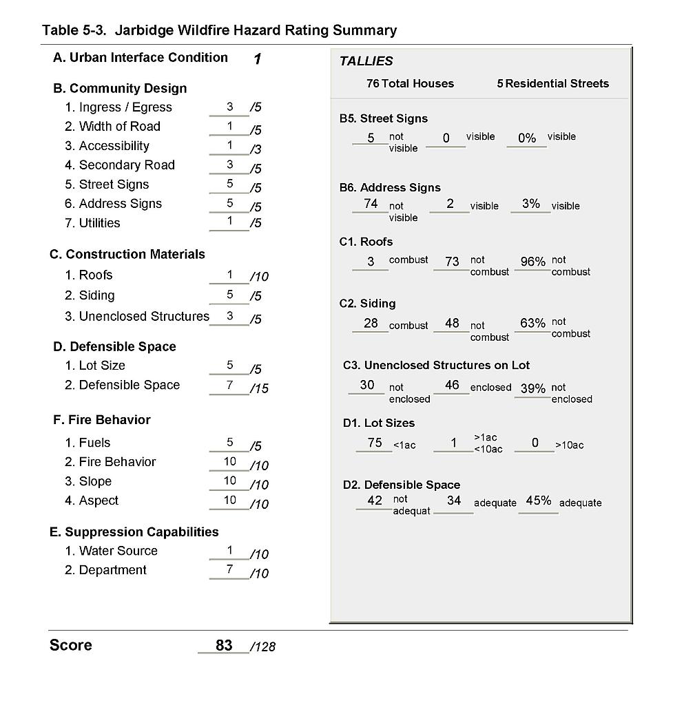 |
Figure 5-1Jarbidge Mitigation Projects |
 |
Figure 5-2Jarbidge Classification of Fuel Hazard |
 |
Figure 5-3. Jarbidge Fuel Hazard Photo Points
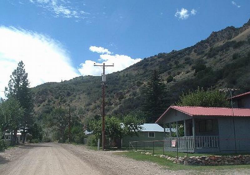
Photo Point 1. 4636728N, 630185E, 090°E. Fuels on the west side of Jarbidge consist of juniper, subalpine fir, aspen, and mountain mahogany. Ladder and ground fuels include basin wildrye, cheatgrass, perennial grasses, big sagebrush, elderberry, and rabbitbrush. Steep slopes in the community increase the potential for hazardous wildfire behavior.
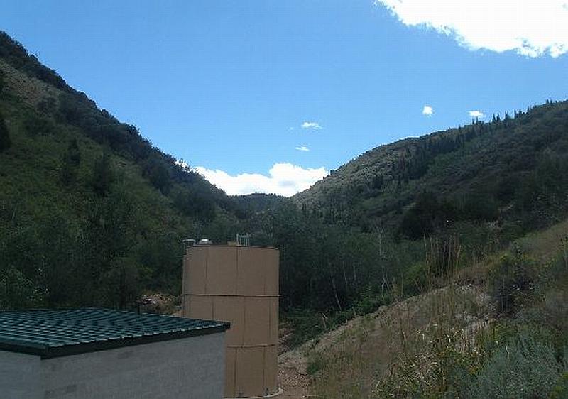
Photo Point 2. 4636891N, 629611E, 180°S. This water treatment facility is situated at the base of a steep canyon with heavy fuel loading. Critical features such as this need special attention to fuels reduction treatments to protect the resources.