![]()
![]()
41.0 Clover Valley
41.1 Risk and Hazard Assessment
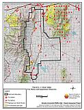
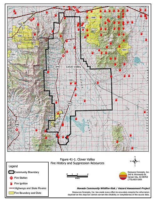
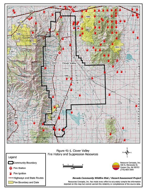
Clover Valley is a rural community with several ranches scattered throughout the valley. Clover Valley is located in central Elko County on Highway 93 south of Wells between the East Humboldt Range and the Pequop Mountains at an elevation of approximately 5,600 feet. The community boundary identified for this report is shown in Figure 41-1.
The rural ranch community type does not lend itself to the standard community assessment procedures. Community design, suppression resources, and fuel hazard conditions are described qualitatively for the rural ranch communities. Within this community type, the homes are often surrounded by landscaped yards, corrals, or agricultural pastures with no wildland vegetation in close proximity to structures. These common characteristics usually contribute to a low risk of damage or direct loss of homes due to wildfires. Hay and alfalfa fields, stockpiled bales, livestock, ranching and farming equipment, and fuel tanks are assets that require special planning for protection during a wildfire because of their considerable value to ranchers and farmers
41.1.1 Community Design and Defensible Space
Clover Valley is considered a rural ranch community. All of the ranch residences are surrounded by irrigated agricultural fields and pastures. Defensible space is not a primary risk factor because the agricultural fields provide a buffer zone between residences and any wildland fuels.
41.1.2 Suppression Capabilities
Wildfire Protection Resources
Clover Valley has a twenty member volunteer fire department. Table 41-1 lists the types of wildfire resources, cooperating partners, and equipment available for initial response to Clover Valley in the event of a reported wildfire. Additional resources are available through the Deeth-Starr Valley VFD, the Wells VFD, the Bureau of Land Management Elko Field Office, the Nevada Division of Forestry, and the US Forest Service as described in Section 4.1.1.
| Type of Equipment | Amount of Equipment | Cooperating Partner (Resource Location) |
|---|---|---|
| Type 3 Engine Type 6 Engine Water Tender |
1 1 1 |
Clover Valley VFD (Clover Valley) |
| Type 1 Engine Type 2 Water Tender |
2 1 |
Deeth/Starr Valley VFD (Deeth) |
| Type 1 Engine Type 3 Engine |
2 1 |
Wells VFD (Wells) |
| Type 6 Engine | 1 | Nevada Division of Forestry (Wells - seasonal) |
| Type 4 Engine | 1 | Bureau of Land Management (Wells) |
| Type 6 Engine | 1 | US Forest Service (Wells) |
| Source: Sam Hicks, Nevada Division of Forestry Elko County Prevention Captain; Bobby Lee, Clover Valley VFD Chief (seasonal for Nevada Division of Forestry) | ||
Water Sources and Infrastructure
Water available for fire suppression resources in Clover Valley varies. Water sources including individual wells, storage tanks, and large ponds that could be used for drafting or dip spots for fire suppression are twenty minutes or less away round trip. Volunteers have access to irrigation wheel lines for filling fire apparatus.
Fire Protection Personnel Qualifications
All Clover Valley VFD firefighters have received State Fire Marshal Firefighter I and II training for structure protection, and have received training from the Nevada Division of Forestry and cooperating agencies to meet the minimum National Wildfire Coordinating Group basic wildland standards.
Work Load
The Clover Valley VFD responded to 55 calls in 2003:
- 10 emergency medical calls.
- 30 wildland/brush fire calls.
- 15 other calls.
Financial Support
Funding for the Clover Valley VFD is provided through the Elko County General Fund and the Nevada Division of Forestry as authorized under NRS 473. Through an agreement with Nevada Division of Forestry, each volunteer fire department is paid per incident and per vehicle used in a wildfire. In Elko County, volunteer fire departments within the Northeastern Area Fire Protection district are not funded by property taxes as is typically the case elsewhere in Nevada.
Community Preparedness
Elko County has an active Local Emergency Planning Committee and has adopted an emergency plan that includes a hazardous materials response plan and an all-risk disaster response plan, which is updated annually. Clover Valley is included in the County plan.
41.1.3 Factors Affecting Fire Behavior
The vegetative fuel hazard in the Clover Valley interface area varies from moderate in the lower elevation areas to high in the upper elevation area. Fuels in the valley bottom at the south end of the valley was estimated at two to three tons per acre consisting of cheatgrass, basin wildrye, rabbitbrush, sagebrush, and greasewood. Cheatgrass growth is dependent on annual moisture and will produce increased fuel volumes and elevate fuel hazard conditions in years of higher than average precipitation. The fuels at the northern end of the valley include pinyon and juniper trees, with fuel loading estimated at two and eight tons per acre. The terrain within Clover Valley is generally flat; however, there are steep slopes surrounding the valley. The prevailing wind direction is from the south and southwest. There is a history of afternoon thunderstorms and dry lightning strikes in the area.
41.1.4 Fire Behavior Worst Case Scenario
The worst case scenario for a wildfire in the area surrounding Clover Valley would be a fire starting at the south end of the valley in two to three foot tall shrubs, with a strong wind from the south/southwest. Risks to residents in the area are somewhat mitigated by agricultural fields that provide a buffer zone between structures and wildland fuels. A wind-driven fire could result in a large acreage incident. There are very limited fire resources in the area and additional fire suppression resources are over an hour away.
41.1.5 Ignition Risk Assessment
Clover Valley has a moderate to high risk of ignition based on fire history in the area and the potential for increased fuel loading from annual grasses in high precipitation years. There is a moderate wildfire history in the public lands surrounding the community and a history of lightning strikes around the community. The primary risk of ignition in Clover Valley is lightning, although ignitions from the railroad also pose potential ignition risks.
41.2 Risk and Hazard Reduction Recommendations
The risk and hazard reduction recommendations for Clover Valley address the primary concern for maintaining defensible space and assuring water availability for fire suppression.
41.2.1 Defensible Space Treatments
Despite the reduced risk of damage or loss to structural properties, Clover Valley has other unique conditions due to the remote location and relative isolation. Hay and alfalfa fields, stockpiled bales, livestock, ranching and farming equipment, and fuel tanks are assets that require special planning for protection against wildfire because of their considerable value to ranchers and farmers.
Property Owners Recommendations
- Remove, reduce, and replace vegetation around homes according to the guidelines in Appendix E. This area should be kept:
- Lean: There are only small amounts of flammable vegetation.
- Clean: There is no accumulation of dead vegetation or other flammable debris.
- Green: Existing plants are healthy and green during the fire season.
- Store firewood a minimum distance of thirty feet from structures.
- Maintain areas under wood decks and porches free of weeds and other flammable debris. Enclose these areas when possible. Box in eves and cover attic and other ventilation openings with very fine metal wire mesh to prevent embers from entering the attic or crawl space.
- Clear all vegetation and combustible materials around propane tanks and other fuel storage tanks for a minimum distance of ten feet.
- Prune all tree branches to a minimum distance of fifteen feet from buildings, paying special attention around chimneys.
- Immediately dispose of cleared vegetation when implementing defensible space treatments. This material dries quickly and poses a fire hazard if left on site.
- Maintain the defensible space as needed.
- Install spark arrestors on chimneys.
- Create a fuelbreak of bare ground or gravel for 100 feet around stockpiled commodities such as hay or alfalfa. Because it is dried plant material, stacked or baled hay is vulnerable to ignitions, as much from internal combustion as from outside sources.
- Seed a mixture of fire resistant species around residential structures and ranch outbuildings. This will enhance fire safety, which is especially important in these rural areas where water sources are limited or distant.
41.2.2 Fire Suppression Resources
Clover Valley VFD and Nevada Division of Forestry
- Upgrade communication system to narrow band technology for compatibility with cooperating agencies.
Property Owners
- Develop a system for backup power in the case of a large wildland fire.
41.2.3 Fuels Reduction
Union Pacific Railroad
- Mow or reduce vegetation within a minimum distance of twenty feet on both sides of the railroad tracks. Reseed according to the recommendations in Appendix E if necessary, to prevent cheatgrass or other noxious weed invasion. Maintain low growing, low-density fuel volumes within the railroad corridors to reduce the wildfire ignition risk and hazard.
41.2.4 Public Education
A public education program that explains fire safe measures in clear and emphatic terms will have an impact on residents of the wildland-urban interface. Informed community members will be more inclined to make efforts to effectively reduce wildfire hazards around their homes and neighborhoods.
University of Nevada Cooperative Extension
- Develop a version of the “Living With Fire” publication tailored to the concerns of rural Nevada ranchers. The publication should include solutions for power back up, foam and other fire retardant products, fire resistant seeding, suggested site plans, and water storage adapted for filling fire engines and water tenders.
41.3 Summary of Recommendations
| Involved Party | Recommended Treatment | Recommendation Description |
|---|---|---|
| Property Owners |
Defensible Space | Remove, reduce, and replace vegetation around homes, equipment, and hay storage areas according to the guidelines in Appendix E. Maintain the defensible space as needed. Create a fuelbreak of bare ground or gravel for 100 feet around stockpiled commodities such as hay or alfalfa. Because it is dried plant material, stacked or baled hay is vulnerable to ignitions, as much from internal combustion as from outside sources. Seed a mixture of fire resistant species around residential structures and ranch outbuildings. This will enhance fire safety, which is especially important in these rural areas where water sources are limited or distant. |
| Fire Suppression Resources | Develop a system for backup power in the case of a large wildland fire. | |
| Union Pacific Railroad | Fuel Reduction | Mow and maintain low vegetation within a minimum distance of twenty feet on both sides of the railroad tracks. |
| Clover Valley VFD and Nevada Division of Forestry | Fire Suppression Resources | Upgrade communication system to narrow band technology for compatibility with the new 2005 system, to include repeaters for adequate communication. |
| Nevada Cooperative Extension | Public Education | Develop a rural Nevada version of the “Living With Fire” publication tailored to the concerns of rural Nevada ranchers and farmers. |
Figure 41-1Clover Valley Fire History and Suppression Resources |
 |