![]()
![]()
5.0 Dyer/Fish Lake Valley
5.1 Risk and Hazard Assessment
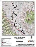
Dyer/Fish Lake Valley is located in western Esmeralda County, just east of the Nevada/California border. Nevada State Route 264 bisects the valley. Figure 5-1 provides a map of the community boundary. The community hazard assessment classified Dyer/Fish Lake Valley in the Low Hazard category (40 points). A summary of the factors that contributed to that hazard rating is included in Table 5-3. The factors contributed to the low hazard score included sparse vegetation, good defensible space in subdivisions, and homes constructed of non-combustible building materials. The rural ranch setting where many residences are protected by a buffer of agricultural land also lowered the community hazard score.
5.1.1 Community Design
Dyer/Fish Lake Valley is a combination of rural ranch homes and small, scattered clusters of residences surrounded by agricultural land. Many pastures and fields are adjacent to wildland fuels but wildland vegetation typically does not continue into development areas. During the field inventory, a total 115 homes were observed on parcels of between one and ten acres in size, and 51 homes were on parcels of greater than ten acres.
- Roads: Nevada State Route 264 is the major transportation route through Fish Lake Valley. The highway is 24 feet wide, paved, and with adequate turnaround space for fire suppression equipment. There are numerous secondary roads that are actually long driveways into farms or ranches. These roads are primarily graded dirt, twelve to twenty feet wide that often dead-end at the farm or ranch headquarters. Many do not provide adequate width for two-way vehicle passage or adequate turnaround space for fire suppression equipment.
- Signage: Street signs were present and visible on all but six of the secondary roads in the community. Clear and visible street signs and residential addresses are important in locating homes during low visibility conditions that may occur during a wildfire. Residences in Dyer/Fish Lake Valley are situated in such a manner that there would be little chance of fire suppression personnel being unable to locate a particular structure that needed protection even under the low visibility conditions that may occur during a wildfire.
- Utilities: Utilities were all above ground. Power lines have been properly maintained minimizing the possibility that arcing may start fires in nearby vegetation.
5.1.2 Construction Materials
Of the 166 homes observed in the interface area, 164 were built with noncombustible siding material. All but two homes had fire resistant roofing materials such as composition roofing, metal, or tile. Less than twenty percent of the homes observed had unenclosed balconies, porches, decks or other architectural features that provide areas where sparks and embers could be trapped, smolder, and ignite, rapidly spreading fire to the home.
5.1.3 Defensible Space
Ninety-six percent of the surveyed homes had landscaping that meets the minimum standard for defensible space.
5.1.4 Suppression Capabilities
Wildfire Protection Resources
Fire protection in Dyer/Fish Lake Valley is provided by the Fish Lake Valley Volunteer Fire Department, which, at the time of interviews for this report was comprised of fourteen volunteers. Table 5-1 lists the types of wildfire resources and equipment available to Dyer/Fish Lake Valley in the event of a reported wildland fire. Additional cooperating wildfire suppression agencies, equipment, and resources are listed in Table 4-2.
| Type of Equipment | Amount of Equipment | Cooperating Partner (Resource Location) |
|---|---|---|
| Type 6 Engine Type 3 Engine Water Tender |
2 1 1 |
Fish Lake Valley Volunteer Fire Department (Fish Lake Valley) |
| Source: Personal Communication with Chief Brent Flaming, Fish Lake Valley Volunteer Fire Department. | ||
Water Sources and Infrastructure
Water availability for fire suppression resources for Dyer/Fish Lake Valley includes private and agricultural wells, and two creeks in the area that could be used for drafting sites, depending upon water levels.
Detection and Communication
Fires in Dyer/Fish Lake Valley are reported through 911 calls to the Esmeralda County Sheriff’s Office in Goldfield. Fires are communicated to fire response personnel through Esmeralda County Sheriff’s Office Emergency Dispatch using radios and pagers. The Esmeralda County Sheriff’s Office and the Volunteer Fire Departments have access to the state mutual aid frequencies. The radio system is compatible with neighboring agencies.
Fire Protection Personnel Qualifications
The Fish Lake Valley VFD volunteers do not have wildland fire training, and their limited structure firefighting training does not meet Firefighter I standards. Fish Lake Valley VFD does not utilize the Red Card system. Red Card certification is part of a fire qualifications management system used by many state and all federal wildland fire management agencies. This certification indicates that an individual is qualified to fight wildland fires.
Work Load
The Fish Lake Valley Volunteer Fire Department responded to nine calls in 2003. Three were wildland/brush fire calls.
Financial Support
Financial support for the Fish Lake Valley Volunteer Fire Department comes primarily from the Esmeralda County General Fund. The Fire Department also pursues grant funding when available.
Community Preparedness
Esmeralda County has an active Local Emergency Planning Committee and has adopted an emergency plan that includes a hazardous material plan, a disaster plan, and an emergency evacuation plan for hazardous materials. Dyer/Fish Lake Valley is included in these county plans.
5.1.5 Factors Affecting Fire Behavior
The terrain around the Dyer/Fish Lake Valley community is predominantly flat. The prevailing wind is from the west/southwest in the late afternoon. However, due to topography, surface winds often come from the southeast, moving up-valley. The fuel loading in the Dyer/Fish Lake Valley interface area is generally light, estimated at less than one ton per acre. Fuels consist of Bailey’s greasewood, shadscale, and four-wing saltbush, with halogeton and Russian thistle in disturbed areas and abandoned agricultural fields. The overall fuel hazard was rated low for the Dyer/Fish Lake Valley community.
5.1.6 Fire Behavior Worst Case Scenario
The worst-case scenario for a wildland fire in the area surrounding Dyer/Fish Lake Valley would involve a wind-driven fire threatening the town from the west or southwest in the mid-afternoon on a high hazard day. The scenario would be worsened if mutual aid resources were unavailable due to their assignment elsewhere or if volunteer response was limited. The fuel load in the area precludes a major wildfire event occurring in the valley, but in a high moisture year, annual grass production could increase fuel loading, providing the continuity needed to carry a fire. Flame lengths would likely be less than four feet. Irrigated agricultural lands are effective fuelbreaks around much of the community.
5.1.7 Ignition Risk Assessment
The ignition risk in Dyer/Fish Lake Valley is very low. There is no wildfire history in the area surrounding the community and there are no recorded fire ignitions anywhere in the valley. The primary risk of ignition in Dyer/Fish Lake Valley is a human caused ignition.
5.2 Bureau of Land Management Site Assessments
The Bureau of Land Management Battle Mountain Field Office conducted a site assessment in the Dyer area in March 2003. The field team found a very low potential for catastrophic wildfire due to low, sparse vegetation and good community design. No fuel reduction projects were recommended. The RCI Project Team concurred with the BLM recommendations.
5.3 Risk and Hazard Reduction Recommendations and Responsibilities
Recommendations for Dyer/Fish Lake Valley primarily address community coordination and fire hazard awareness.
5.3.1 Defensible Space Treatments
Defensible space treatments are an essential first line of defense for residential structures. The goal of the treatments is to significantly reduce or remove flammable vegetation within a prescribed distance form structures. (Refer to Appendix E for the recommended defensible space area). Defensible space reduces the fire intensity and improves firefighter and homeowner chances for successfully defending a structure against oncoming wildfire.
Property Owner Responsibilities
- Remove, reduce, and replace vegetation around homes according to guidelines provided in Appendix E. This area should be kept:
- Lean: There are only small amounts of flammable vegetation,
- Clean: There is no accumulation of dead vegetation or other flammable material including woodpiles, and
- Green: Existing plants are healthy and green during the fire season.
- Immediately remove cleared vegetation to an approved disposal site. This material dries quickly and poses a fire risk if left on site. Refer to the Defensible Space fact sheet in Appendix E for clearance guidelines.
- Keep the area beneath unenclosed porches and decks free of accumulated vegetation or other flammable debris. Enclose these areas when possible.
- Store woodpiles at least thirty feet from any structure.
- Clear vegetation and combustible materials for at least ten feet around propane tanks.
- Where cheatgrass or other annual grasses have become dominant within the defensible space zone, areas should be mowed prior to seed set or treated with an application of pre-emergent herbicide. Treatments may need to be repeated for several years to ensure that the bank of unwanted annual plant seeds has been depleted. Refer to Appendix E for a recommended seed mixture and planting guidelines that can be used in conjunction with annual grass removal.
- Irrigate trees and shrubs in close proximity to structures. This will increase their fire resiliency especially during drought conditions.
- Mow or remove brush growing against wood fences in the community.
- Install spark arrestors on chimneys.
- Maintain defensible space annually.
5.3.2 Training and Equipment
Adequate training and equipment are critical to volunteer fire departments, especially those located in remote geographic regions of Esmeralda County such as Fish Lake Valley.
Fish Lake Valley Volunteer Fire Department Responsibilities
- Require wildland firefighter training for all volunteers.
- Meet annually with the BLM for coordination of their pre-attack plan.
- Distribute copies of the publication entitled “Living With Fire” to all residents. This publication is available free of charge from the University of Nevada Cooperative Extension.
Nevada State Fire Marshall Responsibility
- Provide structure firefighting training to all volunteer fire personnel to meet the minimum State of Nevada Fire Marshal standards.
Bureau of Land Management Responsibility
- Provide wildland firefighting training to meet the minimum standards for Red Card qualifications including Wildland Safety Training and fire shelter use.
| Responsible Party | Recommended Treatment | Recommendation Description |
|---|---|---|
| Property Owners | Defensible Space | Remove, reduce, and replace vegetation around homes according to the defensible space guidelines provided in Appendix E. Maintain this defensible space annually. Mow or otherwise remove vegetation growing or accumulated along fences. Install spark arresters on chimneys. |
| Fish Lake Valley Volunteer Fire Department | Training and Equipment | Coordinate with BLM and require wildland firefighter training for all volunteer firefighters. Meet annually with the BLM to review their pre-attack plan. Distribute copies of "Living With Fire" to all residents. |
| Nevada State Fire Marshall | Training and Equipment | Provide training for structure fire suppression to volunteers to meet Firefighter 1 and 2 standards. |
| Bureau of Land Management | Training and Equipment | Provide Basic Wildland Firefighter Training to volunteers including safety and deployment of fire shelters. |
Figure 5-1Dyer/Fish Lake Valley Suppression Resources |
 |
Table 5-3Dyer/Fish Lake Valley Wildfire Hazard Rating Summary |
 |