![]()
![]()
3.0 Description of the County
3.1 Demographics, Location, Topography, and Climatic Data
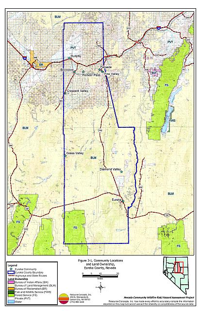
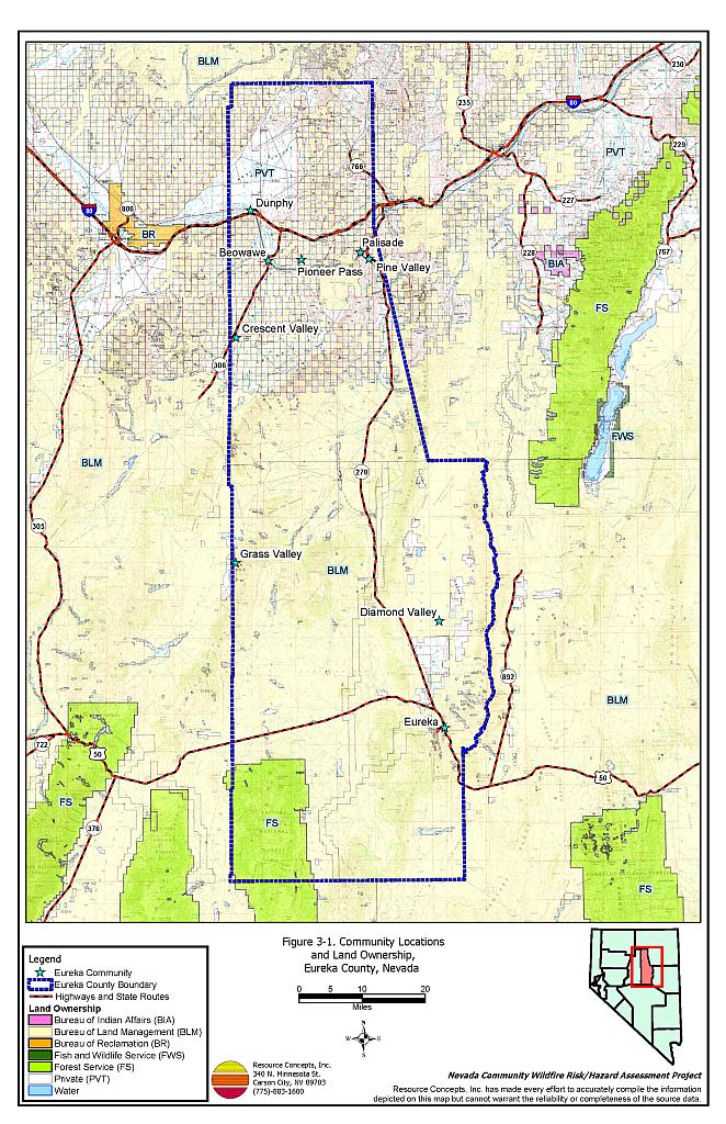
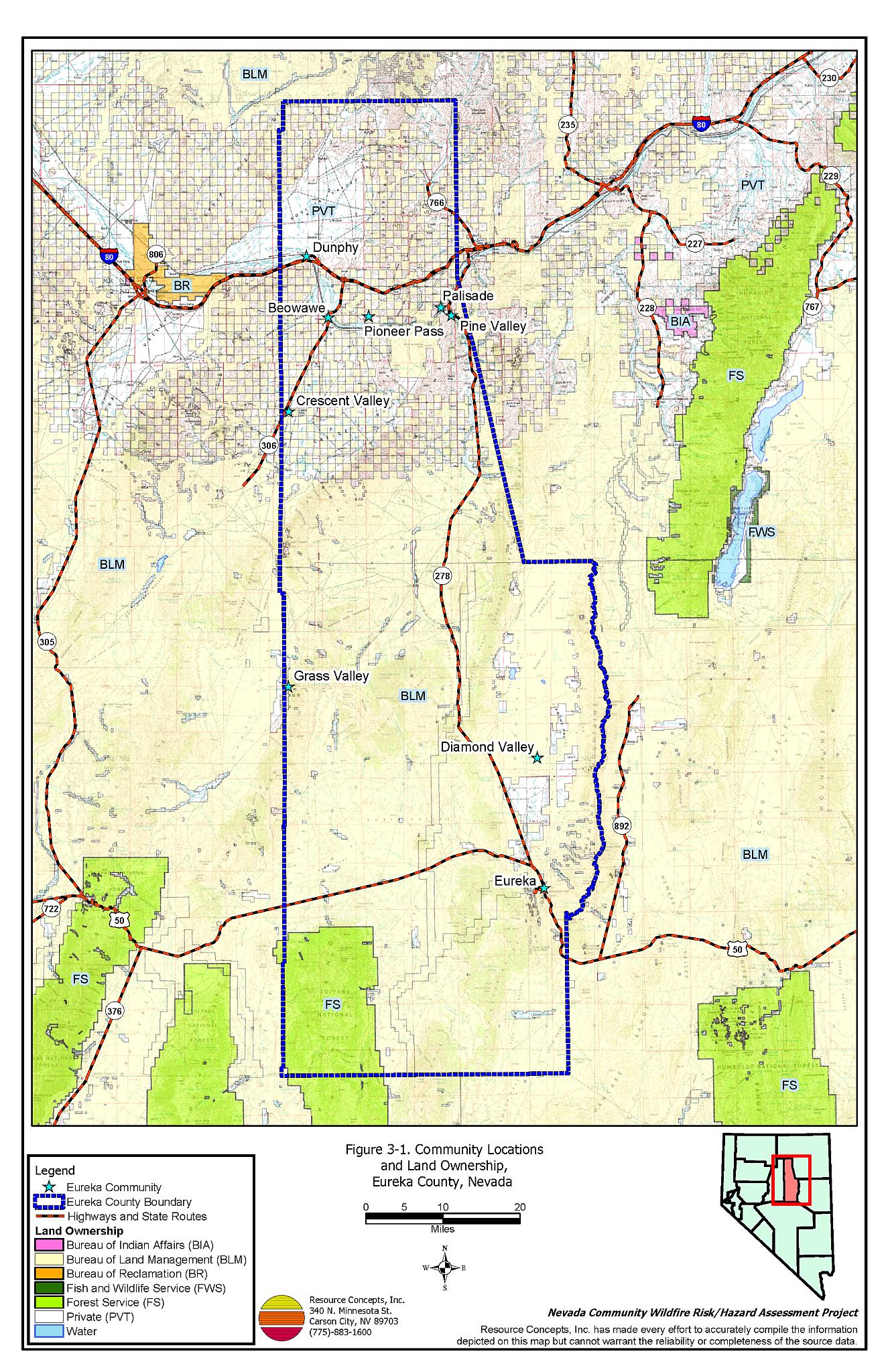
Eureka County is located in central Nevada and is approximately 2.7 million acres in size. The BLM Elko District Office manages the public land in the northern half of the county, while the BLM Battle Mountain District Office manages the southern half. The Forest Service Austin Ranger District manages the Monitor Range in the southern portion of the county. A summary of land management jurisdictions is provided in Table 3-1 and presented on Figure 3-1.
| Land Administrator | Acres | Percent of County |
|---|---|---|
| Bureau of Land Management (Elko and Battle Mountain Districts) |
1,967,000 | 74 |
| US Forest Service (Austin Ranger District) |
144,500 | 5 |
| Private | 561,000 | 21 |
| Total | 2,672,500 | |
| Source: BLM land ownership GIS database. | ||
Nevada Land and Resource Company LLC (NLRC) owns the majority of the private land in Eureka County. NLRC was formed in October 1995 and is the largest private landowner in all of Nevada. NLRC owns in excess of 1.1 million acres along the Interstate Highway 80 corridor in northern Nevada. Most of the land forms a checkerboard pattern of alternating full sections extending twenty miles along both sides of the original railroad right-of-way.
Elevations within Eureka County range from 10,461 feet at Summit Mountain in the Monitor Range to 4,000 feet at the Humboldt River near Dunphy. Rainfall in the county averages about 7.5 inches annually.
The current population estimate for Eureka County is just under 2,000 persons (Nevada State Demographer 2003). Over eighty percent of all jobs are related to mining with Barrick Goldstrike Mines, Inc. and Newmont Gold Company. Each company employs over 1,500 persons, many of whom reside in neighboring Elko County (Nevada Commission on Economic Development, 2004).
3.2 Wildfire History
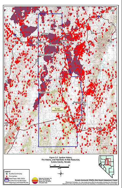
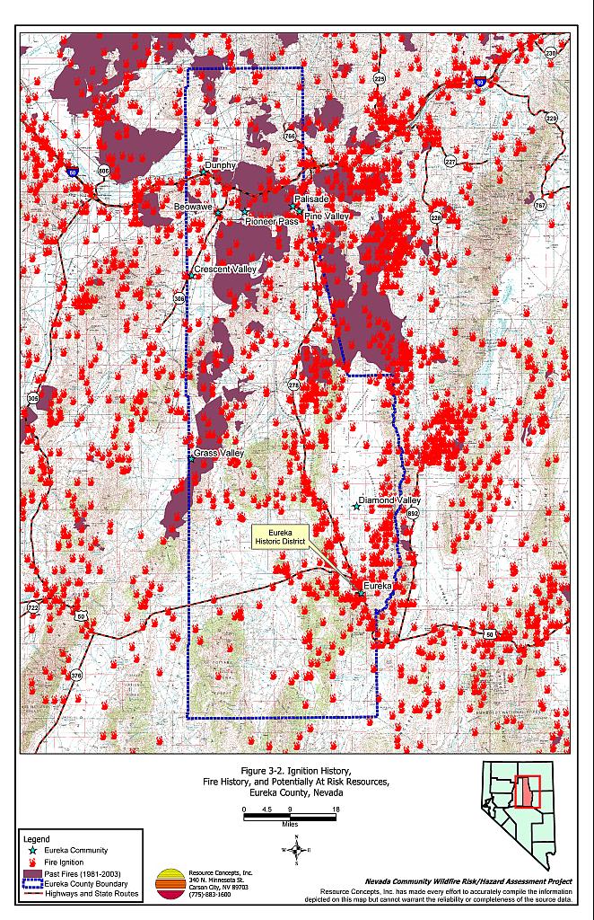
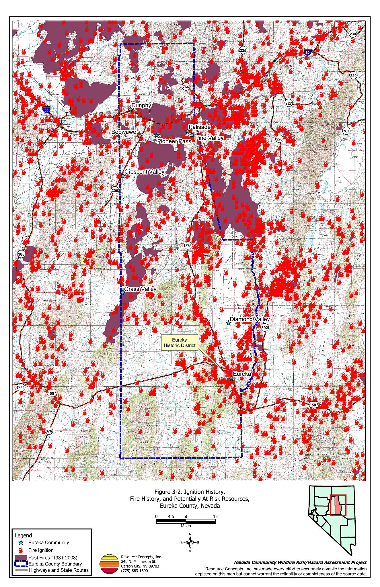
There is a consistent and active record of wildland fire occurrences in Eureka County (Nevada BLM State Office 2004). The recorded data shows that almost 22 percent of the County has burned since 1980. Many additional small fires that are caused by lightning go unreported. Table 3-2 summarizes the fire histories and fire ignitions by year. Figure 3-2 illustrates the fire history on a map of Eureka County.
| Year | Number of Fires | Total Fire Acreage |
|---|---|---|
| 1980 | 16 | 303 |
| 1981 | 28 | 5,268 |
| 1982 | 22 | 3 |
| 1983 | 9 | 9,721 |
| 1984 | 14 | 12,693 |
| 1985 | 44 | 71,171 |
| 1986 | 31 | 4,915 |
| 1987 | 10 | 2,118 |
| 1988 | 16 | 1,663 |
| 1989 | 21 | 3,129 |
| 1990 | 13 | 30 |
| 1991 | 18 | 26 |
| 1992 | 19 | 6,005 |
| 1993 | 16 | 1,565 |
| 1994 | 28 | 1,557 |
| 1995 | 30 | 29,226 |
| 1996 | 50 | 66,956 |
| 1997 | 16 | 44 |
| 1998 | 18 | 4,011 |
| 1999 | 146 | 271,571 |
| 2000 | 30 | 26,828 |
| 2001 | 41 | 59,947 |
| 2002 | 29 | 280 |
| 2003 | 33 | 77 |
| NA | 33 | 2,044 |
| TOTAL | 731 | 581,151 |
| (Fire ignition information provided by NIFC, BLM, USFS, and University of Nevada Cooperative Extension) | ||
3.2.1 Ignition Risk Factors
Ignition risks for wildfires fall into two categories: lightning and human caused. Human caused ignitions can come from a variety of sources such as burning material thrown out of vehicle windows, ignitions from auto accidents, off-road vehicles, railroads, arcing power lines, agricultural fires, campfires, debris burning in piles or burn barrels, matches, and fireworks. In Eureka County database records indicate that of 531 fire incidents recorded, 446 fire ignitions were due to lightning and 85 were human caused. The cause for the remaining fire ignitions was not reported.
3.2.2 Fire Ecology
The science of fire ecology is the study of how fire contributes to plant community structure and species composition. A “fire regime” is defined in terms of the average number of years between fires under natural conditions (fire frequency) and the extent to which dominant vegetation is replaced by fire (fire severity). Natural fire regimes have been affected throughout most of Nevada by twentieth century fire suppression policies. Large areas that formerly burned with high frequency but low intensity (fires more amenable to control, suppression, and rehabilitation) are now characterized by large accumulations of unburned fuels, which once ignited, will burn at higher intensities.
Big sagebrush communities are the most common vegetation types in Nevada with an altered fire regime, now characterized by infrequent, high-intensity, catastrophic fires. Sagebrush requires ten to twenty or more years to reestablish on burned areas, and most often these areas provide conditions for establishment and spread of invasive species before sagebrush reestablishment can occur. Cheatgrass is the most common invasive species to reoccupy sagebrush and pinyon-juniper burned areas in northern Nevada.
Effect of Cheatgrass on Fire Ecology
Cheatgrass is a common, introduced annual grass that aggressively invades disturbed areas, especially burns. The total height and volume of cheatgrass growth is dependent on annual moisture. In years of higher than normal precipitation cheatgrass will produce much higher volumes of highly flammable fuels and can fully occupy interspaces between shrubs creating a continuous and receptive fuel bed capable of rapidly burring into adjacent vegetation. A fire spreading from a cheatgrass stand into adjacent, unburned native vegetation creates additional disturbed areas that are then vulnerable to cheatgrass invasion. Associated losses of natural resource values such as wildlife habitat, soil stability, and watershed functions are additional consequences.
Eliminating cheatgrass presents a difficult challenge. Mowing defensible space and fuelbreak areas each year before seed maturity is effective in reducing cheatgrass growth. In areas where livestock may be utilized, implementing early-season intensive grazing up to and during flowering may aid in depleting the seed bank and reduce the annual fuel load (BLM 2003, Davison and Smith 2000, Montana State University 2004)[1]. The use of pre-emergent herbicides has also proven effective in reducing growth and depleting the seed bank. Any herbicide treatment on public lands must be done in accordance with federal guidelines. Private landowners should proceed with caution if using herbicides, comply with all label instructions and consulting their local extension specialist.
Fire Ecology in Pinyon-Juniper Woodlands
Single-leaf pinyon and Utah juniper are the dominant components of a plant community commonly referred to as pinyon-juniper (P-J). P-J woodlands were primarily confined to the steeper slopes commonly found at higher elevations in the Great Basin prior to European settlement. These woodland communities were characterized by a discontinuous distribution across the landscape and a heterogeneous internal fuel structure. This mosaic pattern of shrubs and trees resulted from the canopy openings created by small and frequent wildfires in the shrublands.
Both pinyon and juniper trees have relatively thin bark with continuous branching all the way to the ground. In dense stands, lower tree branches frequently intercept adjacent ladder fuels, e.g. shrubs, herbaceous groundcover, and smaller trees. This situation creates a dangerous fuel condition where ground fires can be carried into tree canopies, which often results in crown fires. A crown fire is the most perilous of all wildfire conditions and is usually catastrophic in nature since the danger to firefighters is generally too great to deploy ground crews.
3.3 Natural Resources and Critical Features Potentially at Risk
Critical features at risk of loss during a wildfire event can be economic assets, such as agricultural and industrial resources, or cultural features, such as historic structures, archaeological sites, and recreation-based resources.
3.3.1 Historical Registers
Eureka was a boomtown founded around the turn of the century. The entire community is a Historic District listed in the National Register of Historic Places and the Nevada State Register of Historic Places. Historic structures throughout the community are vulnerable to loss from wildfire.
3.3.2 Flora and Fauna
There are sixteen species with potential habitat in Eureka County that are listed as threatened or endangered under the Endangered Species Act or otherwise protected by state legislation. (Nevada Natural Heritage Program database; last updated for Eureka County March 18, 2004). These species are identified in Table 3-3. The Nevada Natural Heritage Program, the Nevada Division of Forestry, and the Nevada Department of Wildlife should be consulted regarding specific concerns and potential mitigation to minimize impacts to these species prior to implementing fuel reduction projects and prior to the occurrence of a catastrophic wildfire. Project recommendations involving federally listed threatened or endangered species require consultation with the US Fish and Wildlife Service.
3.4 Economic Commodities Potentially at Risk
Diamond Valley farmers produce a high value hay, which is baled and stored onsite during the growing season and marketed as specialty feed to dairies and thoroughbred operations, often in other states. Because the growing and harvest season coincides with fire season, stockpiled hay is potentially at risk from smoke damage or ignition by a firebrand or a spot fire.
| Scientific name | Common name | Legislation |
|---|---|---|
| Plants | ||
| Castilleja salsuginosa | Monte Neva paintbrush | NRS 527.260.300 |
| Fish | ||
| Gila bicolor euchila | Fish Creek Springs tui chub | NRS 501 |
| Oncorhynchus clarki henshawi | Lahontan cutthroat trout | ESA-Listed Threatened NRS 501 |
| Mammals | ||
| Brachylagus idahoensis | Pygmy rabbit | NRS 501 |
| Euderma maculatum | Spotted bat | NRS 501 |
| Lontra Canadensis | River otter | NRS 501 |
| Birds | ||
| Accipiter gentiles | Northern goshawk | NRS 501 |
| Athene cunicularia hypugaea | Western burrowing owl | NRS 501 |
| Buteo regalis | Ferruginous hawk | NRS 501 |
| Buteo swainsoni | Swainson’s hawk | NRS 501 |
| Centrocercus urophasianus | Greater sage-grouse | NRS 501 |
| Charadrius alexandrinus nivosus | Western snowy plover | NRS 501 |
| Chlidonias niger | Black tern | NRS 501 |
| Coccyzus americanus occidentalis | Western yellow-billed Cuckoo | NRS 501 |
| Oreortyx pictus | Mountain quail | NRS 501 |
| Otus flammeolus | Flammulated owl | NRS 501 |
| Plegadis chihi | White-faced ibis | NRS 501 |
| Source: Nevada Natural Heritage Program. 2004. Washoe County Rare Species List. Accessed May 4, 2005. Available at www.heritage.nv.gov. | ||
3.5 Previous Fire Hazard Reduction Projects
Eureka County has implemented roadside fuel reduction treatments by reducing vegetation within the road right-of-ways and reseeding with fire resistant species. Roadside treatments have been partially completed around Diamond Valley, Crescent Valley, Grass Valley, and Pioneer Pass, as indicated on the maps in each community section of this report.
3.5.1 Crescent Valley
The Bureau of Land Management Battle Mountain Field Office completed an evaluation of Crescent Valley in November 2002, and an environmental assessment in November 2003. The assessment recommended fuel reduction on approximately 298 acres of public lands northeast of Crescent Valley and 670 acres surrounding the town. The Crescent Valley fuel reduction treatments are scheduled for 2005.
3.5.2 Eureka and Diamond Valley
The Bureau of Land Management Battle Mountain Field Office completed an environmental assessment for Eureka and Diamond Valley in August 2002. The assessment recommended fuel reduction on up to 2,087 acres within a 7,400 acre project area. An update on the status of the fuel reduction treatments in Eureka and Diamond Valley are included in the community sections of this report.
Figure 3-1Community Locations and Land Ownership, Eureka County, Nevada |
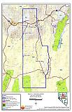 |
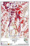
Figure 3-2Ignition History, Fire History, and Potentially At Risk Resources, Eureka County, Nevada |
 |