![]()
![]()
9.0 Eureka
9.1 Risk and Hazard Assessment
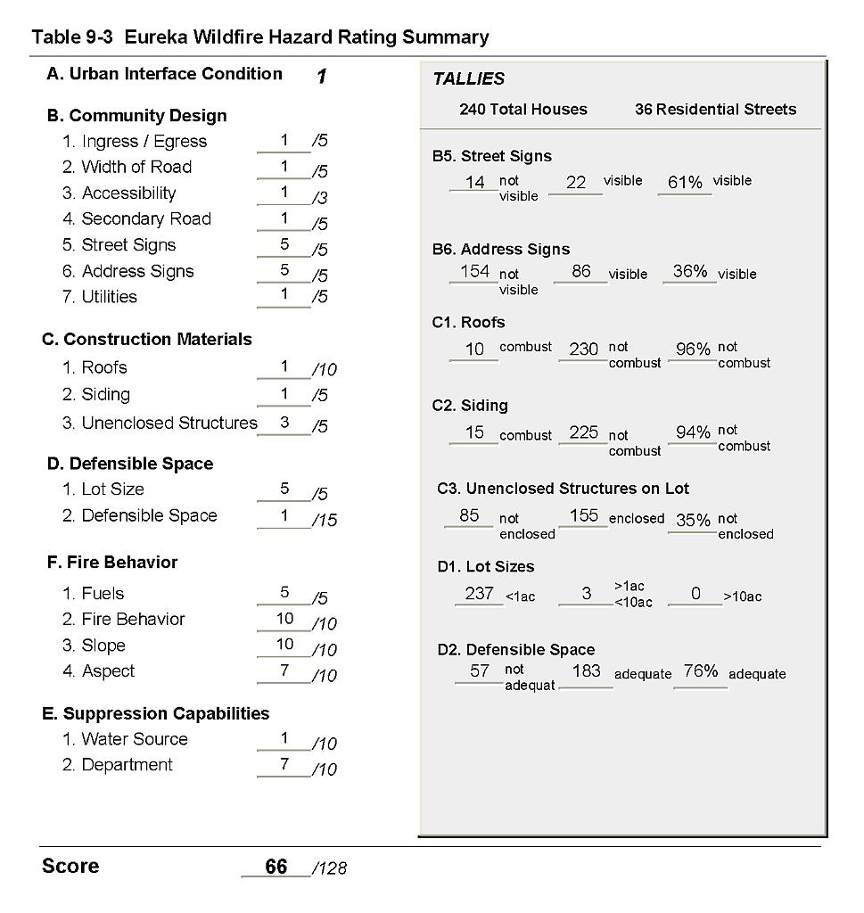
Eureka is located in southeast Eureka County. The town of 446 people is situated on west facing gently sloping terrain on the east side of Eureka Valley. The community hazard assessment resulted in classifying Eureka in the High Hazard category (66 points). The hazard rating is primarily attributed to poor signage, high potential for hazardous fire behavior, limited fire suppression capability, and high density housing. A summary of the conditions that contributed to the hazard rating for Eureka is included in Table 9-3 at the end of this section.
9.1.1 Community Design
The wildland-urban interface area around Eureka is a classic interface condition. There is a clear line of demarcation between buildings and wildland fuels. Wildland vegetation typically does not continue into the development areas. Almost all of the 240 houses assessed are on parcels of less than one acre in size. Three residences are on parcels between one and ten acres in size.
- Access: State Route 50 is the primary access route to Eureka. The highway is at least 24 feet wide. The secondary roads have grades less than five percent and have adequate turnaround space for fire suppression equipment to maneuver.
- Signage: Street signs were visible along two-thirds of the residential streets. Addresses were visible on only one-third of the residences. Clear and visible signage is important to help fire suppression personnel locate residences during poor visibility conditions that occur during a wildland fire.
- Utilities: All of the utilities are above ground. Power line corridors have not been properly maintained free of vegetation and tree branches to minimize wildfire damage to electric utilities and reduce the possibility that sparks will start a fire in adjacent vegetation.
9.1.2 Construction Materials
Almost all of the homes observed in the interface area are built with ignition resistant treated wood siding materials (94 percent) and fire resistant roofing materials such as composition, metal, or tile. One-third of the homes observed had unenclosed balconies, porches, decks or other architectural features that provide areas where sparks and embers can be trapped, smolder, ignite, and rapidly spread fire to the home. Historic homes and buildings in the center of town are not constructed with fire-resistant building materials and could be at risk if the defensible space is not maintained.
9.1.3 Defensible Space
The majority of the homes (76 percent) meet the minimum recommended defensible space to help protect the home from damage or loss during a wildfire.
9.1.4 Suppression Capabilities
Wildfire Protection Resources
The Eureka Volunteer Fire Department provides fire protection for the Eureka community as part of the Nevada Division of Forestry Eureka County Fire Protection District. The VFD has one fire station and reported having 25 volunteers at the time that interviews were conducted for this report. Additional resources are available to respond to a wildland fire from the BLM Battle Mountain and Elko Field Offices and the NDF Carlin Conservation Camp as described in Section 4.1.1. Table 9-1 lists the types of wildfire resources available for initial attack in the event of a reported wildland fire near Eureka.
| Type of Equipment | Amount of Equipment | Cooperating Partner (Resource Location) |
|---|---|---|
| Type 6 Engine Type 4 Engine Water Tender |
1 1 1 |
Eureka Volunteer Fire Department |
| Type 2 Water Tender Search and Rescue Unit Type 4 Engine |
1 1 1 |
Diamond Valley Volunteer Fire Department |
| Source: Mike Rebaleati, Eureka VFD Fire Chief. | ||
In addition to the wildland brush engines stationed at the Eureka Volunteer Fire Department, there are two structure engines that can be used for structure protection during a wildfire. The older engine, structure truck #68, cannot be used outside of the Eureka townsite.
Water Sources and Infrastructure
Water availability for fire suppression in Eureka includes fire hydrants within 500 feet of structures, with a minimum flow capacity of 500 gallons per minute, and several water storage tanks totaling one million gallons. The water system operates on gravity.
Detection and Communication
Periodic patrols and reconnaissance flights are used for fire detection in the Eureka area. Fires are reported through 911 calls. Fires are communicated to fire response personnel from the Eureka County Sheriff’s Office with radios and pagers. There are gaps in radio coverage due to the terrain. There is a community siren in the town.
The Eureka Volunteer Fire Department has access to State mutual aid frequencies and is compatible with neighboring agencies. Compatible radio frequencies are important for communication between engines and strike teams during larger fires when more than one agency is fighting the fire.
Fire Protection Personnel Qualifications
Some of the volunteer firefighters have received the core training to meet the State Fire Marshal Firefighter 1 standards. Some of the volunteers have received wildland training from the Nevada Division of Forestry. The volunteer fire departments in Eureka County use a modified red card system that certifies that a volunteer is qualified for wildland firefighting within their own fire district.
Work Load
The Eureka Volunteer Fire Department responded to fifty wildland/brush fire calls in 2003 and seventy other calls.
Financial Support
Financial support for the Eureka Volunteer Fire Department comes through the NDF Eureka County Fire Protection District which is funded from the Eureka County general fund.
Community Preparedness
Eureka County has a Local Emergency Planning Committee and has adopted an emergency plan for hazardous materials and an all-risk disaster response plan that includes emergency evacuation. The Eureka Volunteer Fire Department distributes the “Living With Fire” publication, has a weed control program, and does roadside vegetation clearance and weeding throughout the community.
9.1.5 Previous Fire Hazard Reduction Projects
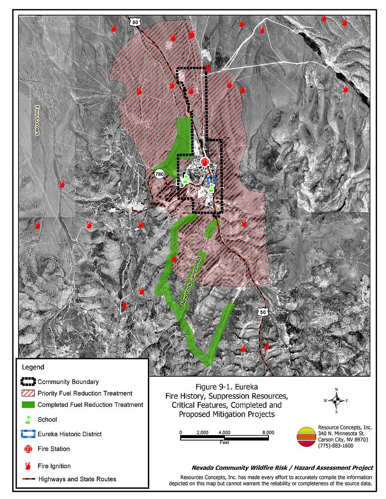
The Bureau of Land Management Battle Mountain Field Office has completed fuel reduction treatments on approximately 210 acres of pinyon-juniper woodlands around Eureka as shown in Figure 9-1. The treatment includes thinning trees to a spacing of thirty feet between tree canopies. Biomass was removed as firewood, chipped on site, or piled and burned.
9.1.6 Factors Affecting Fire Behavior
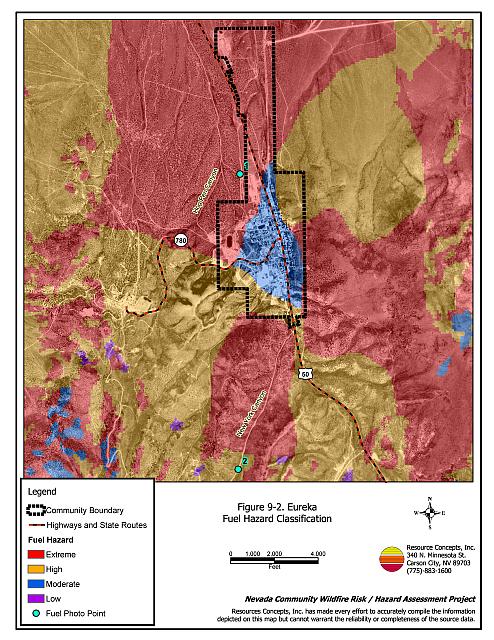
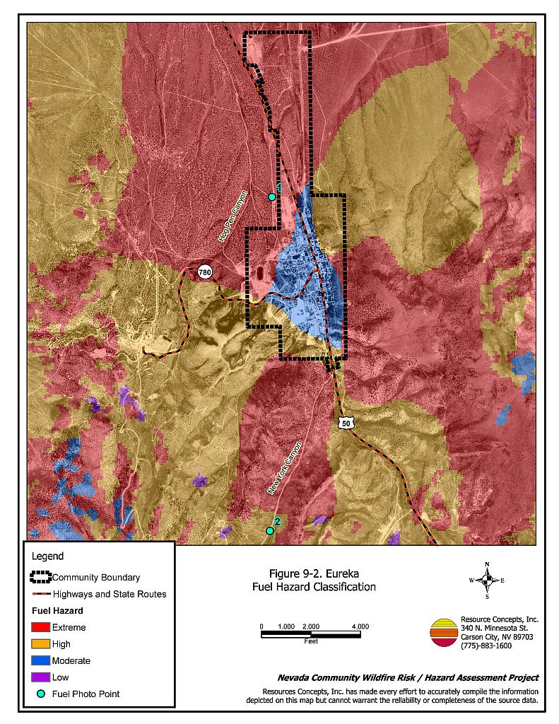
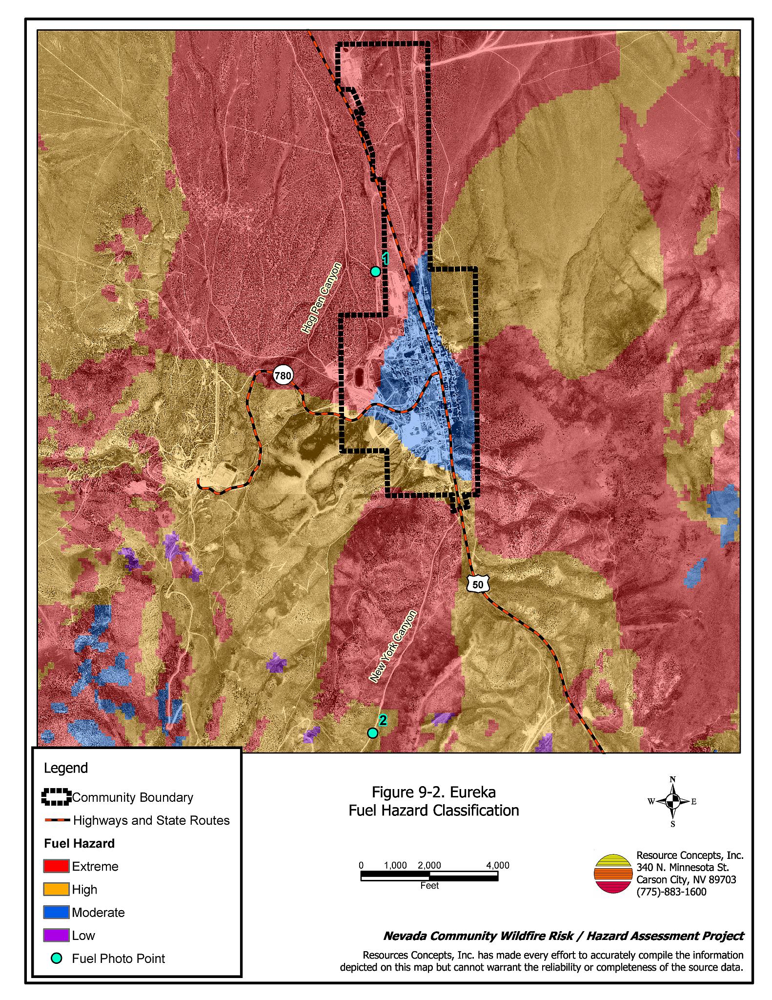
Eureka is situated at the north end of a narrow north-south trending canyon with steep west facing slopes. Fuel hazards in the interface area around the community range from moderate to extreme. Extreme fuel hazard areas are characterized as pinyon-juniper woodlands with trees up to fifteen feet tall and canopy spacing of ten to 25 feet between trees. The estimated fuel loading in woodlands is ten to fifteen tons per acre, or higher. Dense shrublands comprised of big sagebrush, bitterbrush, serviceberry, rabbitbrush, snowberry, and mountain mahogany occur around the community and are interspersed throughout the woodlands. Shrubs are closely spaced, with plants from two to four feet tall. The fuel hazard associated with the shrublands ranges from high to extreme, mostly depending upon slope (higher hazards on steeper slopes). Ground fuels are somewhat sparse and consist of Great Basin wildrye, needlegrass, Indian rice grass, bluegrass, squirreltail, and cheatgrass. High cheatgrass production during a year of higher than normal precipitation will increase the fuel hazard and ignition risk. The Resource Specialist on the RCI Project Team noted that grazing around the community has helped to minimize fuel loading. Moderate fuel hazard areas were mapped within a portion of the community boundary. The fuel hazard conditions around Eureka are shown in Figure 9-2. Fuel condition photo points are included in Figure 9-3.
9.1.7 Fire Behavior Worst-case Scenario
A worst-case scenario would occur in mid to late summer after a year of above normal precipitation and high cheatgrass production. High volumes of dry cheatgrass will provide an easily ignited fine fuel bed that can readily carry fire through the shrubs and woodlands under windy conditions. Strong erratic winds, greater than twenty miles per hour during lightning storms could push fires into the community from any direction. An ignition in a canyon southwest of the community poses the greatest threat since predominant winds are from the southwest and west. The potential for firebrands to ignite spot fires in the community is high. Multiple ignitions caused by dry lightning strikes in the afternoon could easily exceed the initial attack capabilities of the volunteer fire department.
9.1.8 Ignition Risk Assessment
The ignition risk in Eureka is high from lightning and human causes associated with camping and other outdoor recreational activity and vehicle-associated ignitions along Highway 50.
9.2 Risk and Hazard Reduction Recommendations
The risk and hazard reduction recommendations for Eureka address the primary concern for fuel reduction treatments both on public and private lands. Other recommendations pertain to community coordination, public education, and firefighter training that could be initiated to enhance fire safety in Eureka.
9.2.1 Defensible Space Treatments
Defensible space treatments are an essential first line of defense for residential structures. The goal of the treatments is to significantly reduce or remove flammable vegetation within a prescribed distance from structures. (Refer to Appendix E for the recommended defensible space area). Defensible space reduces the fire intensity and improves firefighter and homeowner chances for successfully defending a structure against oncoming wildfire.
Property Owners Recommendations
- Remove, reduce, and replace vegetation around homes according to guidelines provided in Appendix E. This area should be kept:
- Lean: There are only small amounts of flammable vegetation.
- Clean: There is no accumulation of dead vegetation or other flammable debris.
- Green: Existing plants are healthy and green during the fire season.
- Immediately remove cleared vegetation to an approved disposal site. This material dries quickly and poses a fire risk if left on site. Refer to the Defensible Space fact sheet in Appendix E for clearance guidelines.
- Maintain areas under wood decks and porches free of weeds and other flammable debris. Install screens around unenclosed overhangs where possible. Box in eves and cover attic openings with very fine metal wire mesh to prevent embers from entering the attic space.
- Store woodpiles at least thirty feet from any structure.
- Clear all vegetation and combustible materials around propane tanks for a minimum distance of ten feet.
- Where cheatgrass or other annual grasses have become dominant within the defensible space zone, areas should be mowed prior to seed set or treated with an application of pre-emergent herbicide.[6] Treatments may need to be repeated for several years to ensure that the bank of unwanted annual plant seeds has been depleted. Refer to Appendix E for a recommended seed mixture and planting guidelines that can be used in conjunction with annual grass removal.
- Irrigate trees and shrubs in close proximity to structures. This will increase their fire resiliency especially during drought conditions.
- Mow or remove brush growing against wood fences in the community.
- Improve address visibility. Address characters should be at least four inches high, reflective, andcomposed of non-flammable material. Improving visibility of addresses will make it easier for those unfamiliar with the area to navigate during a wildland fire under smoky conditions.
9.2.2 Fire Suppression Resources
Eureka Volunteer Fire Department and Nevada Division of Forestry
- Assure that volunteer firefighters receive annual wildland fire training including the use of fire shelters and State Fire Marshal structure firefighting training.
- Meet annually with the Bureau of Land Management to review pre-attack plans and to coordinate firefighting resources and response procedures including radio coverage and compatibility.
9.2.3 Community Coordination and Public Education
Property Owners
- Form a local chapter of the Nevada Fire Safe Council. The Nevada Fire Safe Council proposes to work on solutions that reduce the risk of loss of lives and property from wildfires in Nevada’s communities. Through establishment of a local Chapter, communities become part of a large information-sharing network that receives notifications of programs and funding opportunities for fire mitigation projects such as those listed in this report. The Nevada Fire Safe Council will accept and manage grants and contracts on the Chapter’s behalf through its non-profit status. The Nevada Fire Safe Council provides assistance and support to communities to complete fire safe plans, set priorities, educate and train community members, and promote success stories of its members. For more information on forming a chapter, contact:
Nevada Fire Safe Council
1187 Charles Drive
Reno, Nevada 89509
(775) 322-2413
www.nvfsc.org
9.2.4 Fuel Reduction Treatments
Eureka Volunteer Fire Department and the Nevada Division of Forestry
- Establish and promote a program for cleaning weeds and debris from around structures and fences in the community.
Propane Company
- Construct a minimum 100-foot wide firebreak of bare ground or gravel around fuel and propane storage facilities at the mine and near town. Fuel tanks at these areas require more defensible space than typically recommended due to the hazardous nature of the tanks and the possibility of catastrophic damage if a fuel tank were to explode during a wildfire.
Electric Utility Company
- Maintain utility right-of-ways by removing trees from beneath power lines and thinning shrubs within fifteen feet of utility poles.
Bureau of Land Management
- Continue the Rural Fire Assistance Program to help get equipment and training for the Volunteer Fire Department.
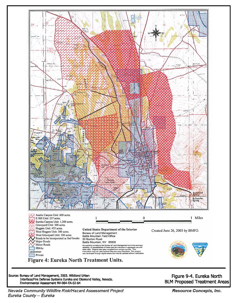
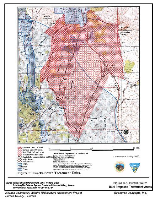
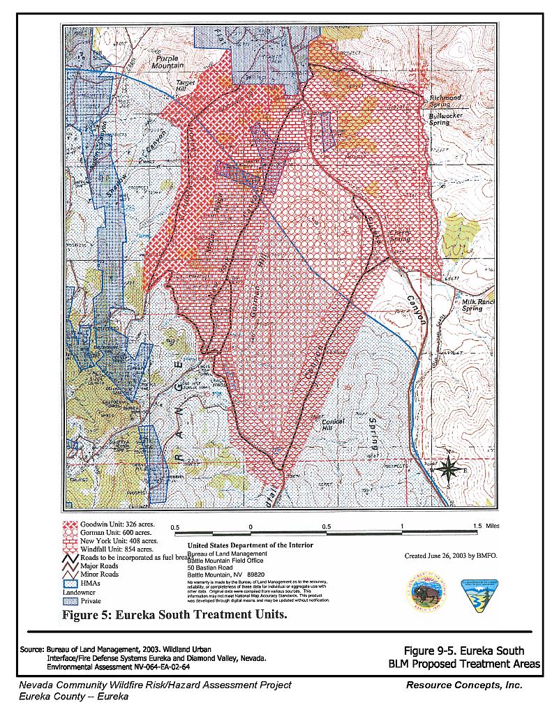
- Continue to implement the fuel reduction treatments identified in the Wildland Urban Interface/Fire Defense Systems Eureka and Diamond Valley, Nevada Environmental Assessment (BLM 2003)as shown in Figures 9-4 and 9-5.
- Prioritize fuel reduction treatments within the wildland-urban interface area shown in Figure 9-1. Thin pinyon and juniper trees to establish a spacing equal to twice the tree height, or thirty feet between the canopies of trees (which ever is greater). Limb trees to a height of four feet, or a maximum of one third the total tree height. Thin, mow or masticate shrubs to reduce the shrub component and break up the fuel bed continuity.
Nevada Division of Forestry
- Work with homeowners and the Eureka Volunteer Fire Department to reduce the sagebrush fuels on the east side of the community along the Public/Private land boundary and adjoin the BLM treatment area.
Eureka County
- Continue and expand the roadside mowing treatments. Consider reseeding these areas with a fire resistant seed mixture such as the one recommended in Appendix E, if necessary, to control cheatgrass and noxious weeds.
- Improve street signage for easy visibility and location of specific areas of town during wildfire conditions.
9.3 Summary of Recommendations
| Involved Party | Recommended Treatment | Recommendation Description |
|---|---|---|
| Property Owners | Defensible Space Treatments | Remove, reduce, and replace vegetation around homes, equipment, and hay storage areas according to the guidelines in Appendix E. Maintain the defensible space annually. |
| Community Coordination | Improve address visibility. Address characters should be at least four inches high, reflective, and composed of non-flammable material. Form a local chapter of the Nevada Fire Safe Council. |
|
| Eureka Volunteer Fire Department Nevada Division of Forestry |
Fire Suppression Resources | Assure that volunteer firefighters receive annual wildland fire training including the use of fire shelters and State Fire Marshal structure firefighting training. Meet annually with the Bureau of Land Management to review pre-attack plans, coordinate firefighting resources and response, and test radio coverage and compatibility. |
| Fuel Reduction Treatments | Establish and promote a program for cleaning weeds and debris from around structures and fences in the community. | |
| Electric Utility Company | Fuels Reduction Treatments | Remove trees and thin shrubs beneath power lines and utility poles. Maintain fifteen feet of clearance around utility poles. |
| Bureau of Land Management | Fuels Reduction Treatments | Continue the Rural Fire Assistance Program to help get equipment and training for the Eureka VFD. Continue to implement the fuel reduction treatments identified in the Wildland Urban Interface/Fire Defense Systems Eureka and Diamond Valley, Nevada Environmental Assessment (BLM 2003) as shown in Figures 9-4 and 9-5. Prioritize fuel reduction treatments within the wildland-urban interface area shown in Figure 9-1. |
| Propane Company | Fuels Reduction Treatments | Create a 100-foot wide firebreak around fuel and propane storage facilities at the mine and near town. |
| Eureka County | Fuels Reduction Treatments | Continue and expand the roadside mowing treatments. Consider reseeding with a fire-resistant seed mixture as necessary to control cheatgrass and noxious weeds. |
| Community Coordination | Improve street signage to improve visibility during wildfire conditions. |
Figure 9-1Eureka Fire History, Suppression Resources, Critical Features, Completed and Priority Mitigation Treatment Areas |
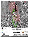 |
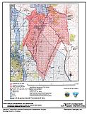
Figure 9-2Eureka Fuel Hazard Classification |
 |
Figure 9-3. Eureka Fuel Hazard Photos
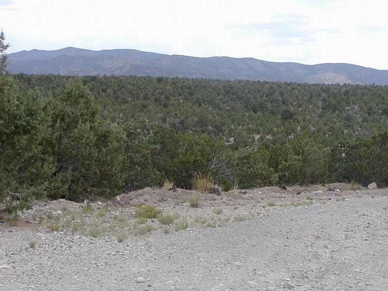
Photo Point 1. 4375063N, 588751E, 270°W. The Pinyon and juniper woodlands west of the community and throughout the community are an extreme fuel hazard, especially on steep slopes. Fuel loading was estimated as high as fifteen tons per acre
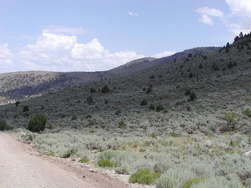
Photo Point 2. 4370953N, 588726E, 30°NE. The sagebrush fuel type was considered a moderate to high fuel hazard depending on slope and shrub density.
Figure 9-4Eureka North BLM Proposed Treatment Areas |
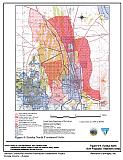 |
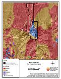
Figure 9-5Eureka South BLM Proposed Treatment Areas |
 |
Table 9-3Eureka Wildfire Hazard Rating Summary |
 |