![]()
![]()
11.0 Palisade
11.1 Risk and Hazard Assessment
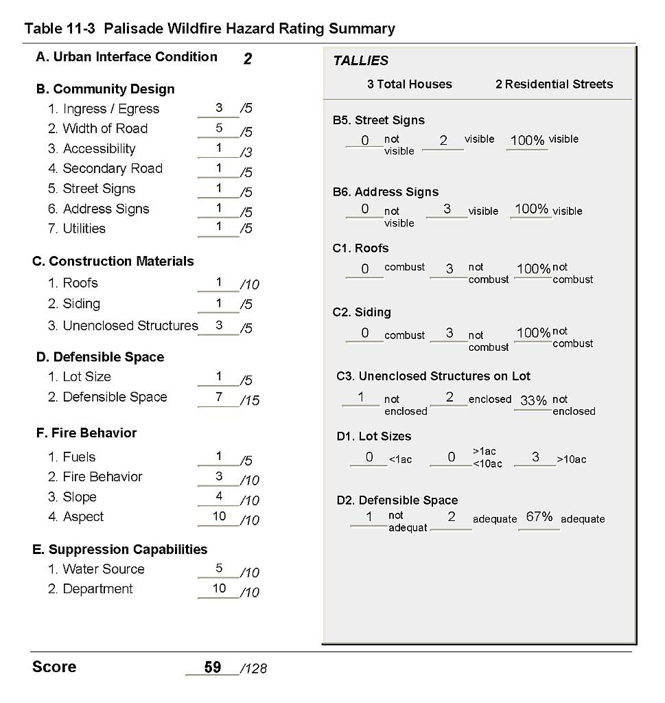
Palisade is an extremely small community in north Eureka County along the Humboldt River. Palisades is a historic railroad community where the narrow gage track from Eureka once met the Union Pacific Railroad that still runs through the community. The community now consists of three residences. The hazard assessment resulted in classifying Palisade in the Moderate Hazard category (59 points). The hazard rating is primarily attributed to limited access, inadequate defensible space, no fire suppression capability, steep terrain and south facing slopes. A summary of the conditions that contributed to the hazard rating for Palisade is included in Table 11-2 at the end of this section.
11.1.1 Community Design
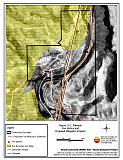
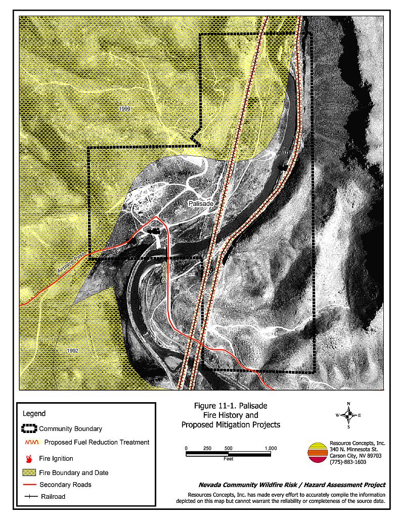
The wildland-urban interface area around Palisade was characterized as an intermix condition. Structures are scattered throughout the wildland area with no clear line of demarcation between wildland fuels and the residences. The three residences assessed in the community were on parcels greater than ten acres in size (Figure 11-1).
- Access: Palisade is accessed via State Route 781, a graded dirt road less than twenty feet wide. All secondary roads have less than five percent grade and provide adequate turn around space for fire suppression equipment to maneuver.
- Signage: Street signs and addresses were not posted in Palisade. Clear and visible street signs and residential addresses are important in locating homes during low visibility conditions that occur during a wildfire. However, residences in Palisade are situated in such a manner that there would be little chance of fire suppression personnel being unable to locate a particular structure that needed protection.
- Utilities: All of the utilities are above ground. Power line corridors have not been properly maintained to minimize wildfire damage to electric utilities and reduce the possibility that sparks created by electric utilities will start a fire in adjacent vegetation.
11.1.2 Construction Materials
All of the homes assessed had ignition resistant siding and roofing materials. One of the homes observed had an unenclosed porch that provides an area where sparks and embers can be trapped, smolder, and ignite, rapidly spreading fire to the home.
11.1.3 Defensible Space
One of the homes assessed did not meet the minimum recommended defensible space criteria to help protect the home from damage or loss during a wildfire. However due to the large parcel size of the three residences, inadequate defensible space on one parcel poses less risk to the neighboring residences.
11.1.4 Suppression Capabilities
Wildfire Protection Resources
Palisade has no organized fire department. The Pine Valley Volunteer Fire Department to the south is the closest fire station. Additional resources are available to respond to a wildland fire from the BLM Battle Mountain and Elko Field Offices and the NDF Carlin Conservation Camp as described in Section 4.1.1. Table 11-1 lists the types of wildfire resources, cooperating partners, and equipment available for initial response to a reported wildland fire in the Palisade area.
| Type of Equipment | Amount of Equipment | Cooperating Partner (Resource Location) |
|---|---|---|
| Engine Type 3 Water Tender Type 2 |
1 1 |
Pine Valley Volunteer Fire Department |
| Type 3 Engine Type 6 Engine Water Tender |
2 1 1 |
Carlin Volunteer Fire Department (Elko County) |
11.1.5 Factors Affecting Fire Behavior
The community lies along the Humboldt River. Fuel loading in the area is estimated at approximately two tons per acre. The shrub layer consists of big sagebrush and rabbitbrush. Ground fuels consist of perennial grasses, knapweed, cheatgrass and thistle. The slopes range from eight to twenty percent. Steeper slopes increase the fuel hazard from moderate to high. The aspect is generally to the south, which increases the potential for low fuel moisture conditions and hazardous fire behavior. Predominant winds blow from the southwest and west. The area north and west of the community was burned in 1999 and is now dominated by cheatgrass, halogeton, Russian thistle, and some rabbitbrush. The cheatgrass fuel hazard can range from low to high depending on slope and annual production (correlated with precipitation levels).
11.1.6 Fire Behavior Worst-case Scenario
A worst-case wildfire scenario for Palisades would occur in mid to late summer after a year of above normal precipitation and high cheatgrass production. High volumes of dry cheatgrass and annual weeds will provide an easily ignited fine fuel bed that can readily carry fire through the brush under windy conditions. Strong erratic winds greater than twenty mph during lightning storms could push fires into the community from any direction. Multiple ignitions caused by dry lightning strikes in the afternoon could exceed the initial attack capabilities of the volunteer fire departments. Fires to the south or west pose the greatest threat since predominant winds are from the southwest and west.
11.1.7 Ignition Risk Assessment
The ignition risk in Palisades was determined to be moderate. There is abundant cheatgrass and some brush around structures, with poor defensible space. Lightning is the primary ignition risk, although human caused ignitions can occur at any time. The Union Pacific Railroad poses certain hazards to the community because sparks from the railroad can ignite vegetation in the railroad corridor.
11.2 Risk and Hazard Reduction Recommendations
The risk and hazard reduction recommendations for Palisade address the primary concern for fuels reduction.
11.2.1 Defensible Space Treatments
Defensible space treatments are an essential first line of defense for residential structures. The goal of the treatments is to significantly reduce or remove flammable vegetation within a prescribed distance from structures. (Refer to Appendix E for the recommended defensible space area). Defensible space reduces the fire intensity and improves firefighter and homeowner chances for successfully defending a structure against oncoming wildfire.
Property Owners Recommendations
- Remove, reduce, and replace vegetation around homes according to the guidelines in Appendix E. The defensible space zone should be kept:
- Lean: There are only small amounts of flammable vegetation.
- Clean: There is no accumulation of dead vegetation or other flammable debris.
- Green: Existing plants are healthy and green during the fire season.
- Clear all vegetation and combustible materials around propane tanks for a minimum distance of ten feet.
- Maintain areas under wood decks and porches free of weeds and other flammable debris. Install screens around unenclosed overhangs where possible. Box in eves and cover attic openings with very fine metal wire mesh to prevent embers from entering the attic space.
- Where cheatgrass or other annual grasses have become dominant within the defensible space zone, areas should be mowed prior to seed set or treated with an application of pre-emergent herbicide.[8] Treatments may need to be repeated for several years to ensure that the bank of unwanted annual plant seeds has been depleted. Refer to Appendix E for a recommended seed mixture and planting guidelines that can be used in conjunction with annual grass removal.
- Immediately remove cleared vegetation to an approved disposal site when implementing defensible space treatments. This material dries quickly and presents a fire hazard if left on site.
- Maintain defensible space as needed to keep the space lean, clean, and green.
11.2.2 Fuel Reduction Treatments
Union Pacific Railroad
- Mow or reduce vegetation within a minimum distance of fifteen feet on both sides of the railroad tracks. Reseed according to the recommendations in Appendix E, if necessary to prevent cheatgrass or other noxious weed invasion. Maintain low density fuel volumes within the railroad corridors to reduce the wildfire ignition risk and hazard.
Electric Utility Company
- Clear all vegetation to maintain a minimum clearance of fifteen feet around all utility poles.
Eureka County
- Organize and implement a weed clean-up and maintenance program for the cemetery. Create 100 feet of defensible space around the perimeter of the cemetery.
University of Nevada Cooperative Extension
- Work with Eureka County to organize a weed control district along the Humboldt River to eradicate whitetop and Russian knapweed.
11.3 Summary of Recommendations
| Involved Party | Recommended Treatment | Recommendation Description |
|---|---|---|
| Property Owners | Defensible Space Treatments | Remove, reduce, and replace vegetation around homes, equipment, and hay storage areas according to the guidelines in Appendix E. Maintain the defensible space annually. |
| Electric Utility Company | Fuels Reduction Treatments | Clear all vegetation to maintain a minimum clearance of fifteen feet around utility poles. Treat or reseed if necessary to control cheatgrass and noxious weeds. |
| Union Pacific Railroad | Fuels Reduction Treatments | Reduce vegetation to maintain a minimum distance of fifteen feet along each side of the railroad tracks. |
| Eureka County | Fuels Reduction Treatments | Organize a program to clean up and maintain weed control in the cemetery. Create 100 feet of defensible space around the perimeter of the cemetery. |
| University of Nevada Cooperative Extension | Public Education | Distribute copies of the publication “Living with Fire.” |
| Fuels Reduction | Coordinate with Eureka County to form a weed control District on the Humboldt River to eradicate Russian knapweed and whitetop. |
Figure 11-1Palisade Fire History and Proposed Mitigation Projects |
 |
Table 11-3Palisade Wildfire Hazard Rating Summary |
 |