![]()
![]()
3.0 Description of the County
3.1 Demographics, location, topography, and climatic data
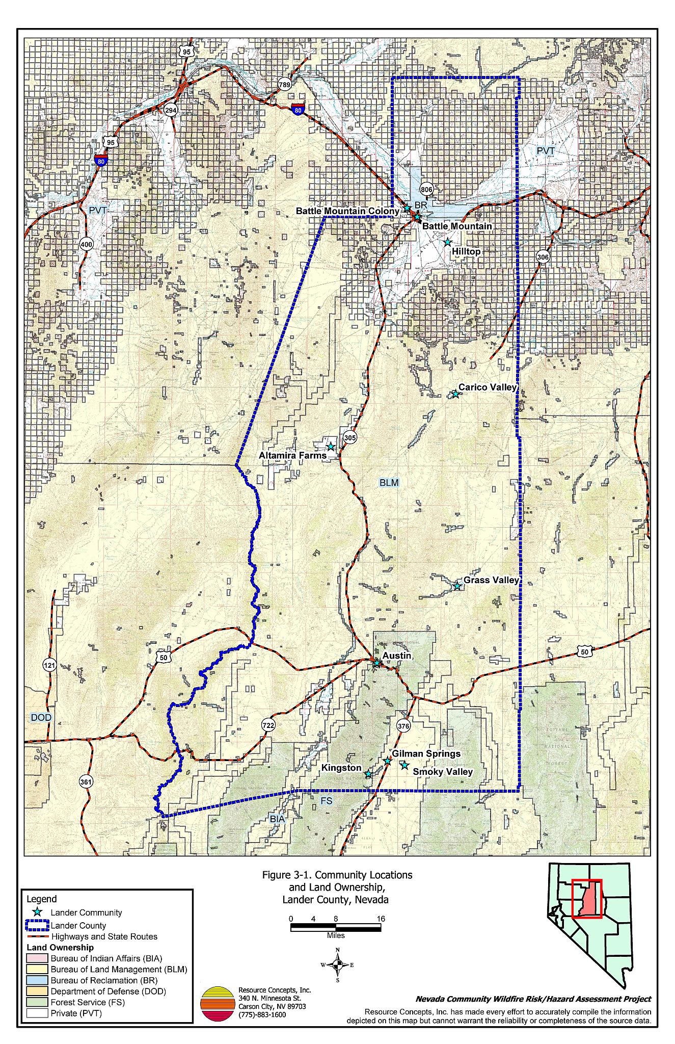
Lander County is located in the north central portion of Nevada and covers approximately 3.5 million acres of land. Land ownership and administration in Lander County is summarized in Table 3-1 (see also Figure 3-1). The majority of land in Lander County is administered by federal agencies.
| Land Administrator | Acres |
|---|---|
| Bureau of Land Management | 2,668,611 |
| US Forest Service | 294,575 |
| Bureau of Indian Affairs | 689 |
| Bureau of Reclamation | 30,150 |
| Private | 534,908 |
| Other (water) | 732 |
| Source: BLM land ownership GIS database. | |
In 2003 the Nevada State Demographer estimated the population of Lander County at 6,822 persons. The Nevada Commission on Economic Development listed major employers in the county as the Cortez Gold Mine, the Echo Bay Minerals Company, and the Lander County School District (Nevada Commission on Economic Development, 2004).
Elevation within the county ranges from 11,473 feet at Bunker Hill in the Toiyabe Range to 4,510 feet at Battle Mountain in the northwest corner of the county. In addition to the Toiyabe Range, most of the Shoshone Range lies within Lander County. Rainfall averages about 7.5 inches (Battle Mountain Chamber of Commerce; Lander County Convention and Tourism, 2004).
3.2 Wildfire History
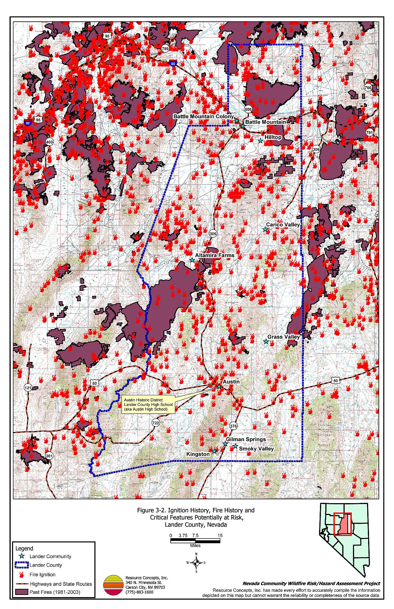
A moderate number of wildfires occurred between 1980 and 2003 in Lander County, with some fires of extensive acreage during the last decade. Figure 3-2 illustrates the wildfire history in Lander County during that period. Table 3-2 summarizes the fire history and fire ignitions by year.
| Year | Number of Fire Ignitions | Total Fire Acreage |
|---|---|---|
| 1980 | 15 | 1,136 |
| 1981 | 18 | 121 |
| 1982 | 22 | 84 |
| 1983 | 11 | 4 |
| 1984 | 35 | 2,516 |
| 1985 | 41 | 35,622 |
| 1986 | 30 | 6,361 |
| 1987 | 11 | 7 |
| 1988 | 18 | 156 |
| 1989 | 20 | 1,901 |
| 1990 | 18 | 114 |
| 1991 | 20 | 823 |
| 1992 | 16 | 691 |
| 1993 | 19 | 1,248 |
| 1994 | 11 | 123 |
| 1995 | 8 | 23,921 |
| 1996 | 33 | 45,884 |
| 1997 | 20 | 42 |
| 1998 | 11 | 7,834 |
| 1999 | 47 | 229,332 |
| 2000 | 26 | 12,036 |
| 2001 | 34 | 85,923 |
| 2002 | 14 | 275 |
| 2003 | 24 | 351 |
| TOTAL | 522 | 456,505 |
| Source: National Interagency Fire Center, Boise, Idaho, Bureau of Land Management, and US Forest Service. | ||
3.2.1 Ignition Risk Factors
Ignition risks for wildfires fall into two categories: lightning and human caused. Human caused ignitions can come from a variety of sources such as burning material thrown out of vehicle windows, sparks from auto accidents, off-road vehicles, railroads, arcing power lines, agricultural fires, campfires, debris burning in piles or burn barrels, unextinguished matches, and fireworks. Database records indicate that of the 522 Lander County wildland fire ignitions between 1980 and 2003, 352 were due to lightning and 120 were human caused. The cause of 50 fires was not reported.
3.2.2 Fire Ecology
Fire ecology is the study of how fire contributes to plant community structure and species composition. A “fire regime” is defined based on the average number of years between fires under natural conditions (fire frequency), and the extent to which dominant vegetation is replaced by fire (fire severity). Natural fire regimes have been affected throughout most of Nevada by twentieth century fire suppression policies. Areas that formerly burned with high frequency but low intensity (fires more amenable to control and suppression) are now characterized by accumulations of unburned fuels, which once ignited burn at higher intensities.
Big sagebrush is the most common plant community in Nevada with an altered fire regime, now characterized by infrequent, high-intensity fires. Sagebrush requires ten to twenty or more years to reestablish on burned areas. During that interim period, these areas can provide conditions for the establishment and spread of invasive species that, in some cases, inhibit sagebrush reestablishment.
Cheatgrass is a common introduced annual grass that aggressively invades disturbed areas, especially burned areas. Replacement of a native shrub community with a pure stand of cheatgrass increases the susceptibility of that area to repeated wildfire ignitions, especially in mid to late summer when desiccating winds and lightning activity are more prevalent. The annual production (volume) of cheatgrass fuel produced each year is highly variable and dependent on winter and spring precipitation amounts. Plants can be sparse and only a few inches tall in a dry year to over two feet tall on the same site in a wet year. In a normal or above normal precipitation year, cheatgrass can be considered a high hazard fuel type. In dry years cheatgrass poses a low fire behavior hazard because it tends to burn with a relatively low intensity. Nevertheless, in every year dried cheatgrass creates a highly flammable fuel bed that is easily ignited and has the propensity to rapidly burn into adjacent cover types that may be characterized by more severe and hazardous fire behavior. The ecological consequence of a fire spreading from a cheatgrass stand into adjacent unburned native vegetation is that additional disturbed areas are thereby opened and vulnerable to cheatgrass invasion. Associated losses of natural resource values such as wildlife habitat, soil stability, and watershed function are additional risks.
Eliminating cheatgrass is an arduous task that focuses on depleting the cheatgrass seed bank in the soil. Mowing defensible space and fuelbreaks annually before seeds mature will reduce cheatgrass growth and reproduction over time. Use of pre-emergent herbicides can have the same effect. Any herbicide treatment on public lands must be done in accordance with federal guidelines. Private landowners should proceed with caution if using herbicides, complying with all label instructions and consulting their local extension specialist. Early season livestock grazing prior to and during flowering is another mechanism for depleting the seed bank (Davison and Smith 2000, BLM 2003, Montana State University 2004)[1]. It may take years of intensive treatment with any of these efforts to fully eliminate cheatgrass from being a dominant component of the vegetation, but it is a necessary process in order to return the landscape to a natural fire cycle and reduce the occurrence of large, catastrophic wildfires.
3.3 Natural Resources and Critical Features Potentially At Risk
Critical features at risk of loss during a wildfire event include economic assets (agricultural and industrial resources) and cultural features (historic structures, archaeological sites, recreation and tourist centers). Key critical features include schools (often used as staging areas or incident command centers during a fire event), and fire stations. Critical features identified in each community are shown on the community map at the end of each community chapter.
3.3.1 Historical Sites
The Austin Historic District and the Lander County School (aka Austin High School) are listed on the National Register of Historical Places and the Nevada State Register of Historical Places. Battle Mountain is the county seat and a historic mining town, however there are no historic sites listed there on either historic register. Established sometime between 1850-60, the town eventually became a major regional freight and trade center. In 1917 the Battle Mountain Colony was established. Austin is an historic Nevada mining town as well, established in 1862. Numerous historic buildings are preserved in Austin, Battle Mountain, and the Battle Mountain Colony and are at risk of being damaged or lost during a major wildfire event.
3.3.2 Recreation
The US Forest Service manages the 294,575 acres of the Humboldt-Toiyabe National Forest that lie within Lander County. Within the National Forest numerous outdoor activities take place, including but not limited to camping, hiking, wildlife viewing, and photography that could be impacted by wildfire. The USFS is responsible for fire safety on National Forest lands, as well as any fuels reduction projects. The Humboldt-Toiyabe National Forest area within Lander County is detailed on Figure 3-1.
3.3.3 Flora and Fauna
Potential habitat is present in Lander County for one species listed as threatened or endangered under the Endangered Species Act. An additional thirteen species are protected by state legislation (Nevada Natural Heritage Program database; last updated for Lander County 18 March 2004). These species are identified in Table 3-3. The Nevada Natural Heritage Program, the Nevada Division of Forestry, and the Nevada Department of Wildlife should be consulted regarding specific concerns and potential mitigation to minimize impacts to these species prior to implementing fuel reduction projects or the occurrence of a wildfire.
| Scientific name | Common name | Legislation |
|---|---|---|
| Plants | ||
| Opuntia pulchella | Sand cholla | NRS 527.060.120 |
| Fish | ||
| Oncorhynchus clarki henshawi | Lahontan cutthroat trout | ESA-Listed Threatened NRS 527.260.300 |
| Mammals | ||
| Brachylagus idahoensis | Pygmy rabbit | NRS 501 |
| Euderma maculatum | Spotted bat | NRS 501 |
| Lontra Canadensis | River otter | NRS 501 |
| Birds | ||
| Accipiter gentilis | Northern goshawk | NRS 501 |
| Athene cunicularia hypugaea | Western burrowing owl | NRS 501 |
| Buteo regalis | Ferruginous hawk | NRS 501 |
| Buteo swainsoni | Swainson’s hawk | NRS 501 |
| Centrocercus urophasianus | Western sage-grouse | NRS 501 |
| Chlidonias niger | Black tern | NRS 501 |
| Oreortyx pictus | Mountain quail | NRS 501 |
| Otus flammeolus | Flammulated owl | NRS 501 |
| Plegadis chihi | White-faced ibis | NRS 501 |
3.4 Previous Fuel Hazard Reduction Projects
The Bureau of Land Management Battle Mountain Field Office Fuels Management Team was recognized in 2004 with a national BLM award for their plans and implementation of fuel reduction projects in the communities within their district. The BLM Battle Mountain Field Office conducted site assessments of the fuel conditions surrounding the communities of Austin, Battle Mountain, Battle Mountain Colony, Hilltop, and Kingston between 2002 and 2003. The Site Assessments include narrative descriptions of fuels, expected fire behavior, treatment alternatives, reference photos, and maps of proposed project areas. An Environmental Assessment was also completed for the proposed fuel reduction treatments in the Austin and Kingston communities.
Treatment alternatives proposed by the BLM to reduce fuel hazards included high intensity, low frequency grazing and greenstrips. Documentation and additional details on these projects are available at the BLM Battle Mountain Field Office. At the time of this report, the BLM greenstrip treatments acres around Austin were reported as completed and some thinning of pinyon and juniper was done. The remainder of the seeding and thinning is scheduled to occur in 2005. The Kingston project is scheduled to be implemented as soon as the community constructs a fence to restrict livestock to the BLM treatment area.
Figure 3-1Community Locations and Land Ownership, Lander County, Nevada |
 |
Figure 3-2Ignition History, Fire History, and Critical Features Potentially At Risk, Lander County, Nevada |
 |