![]()
![]()
9.0 Schurz
9.1 Risk and Hazard Assessment
Schurz is located within the Walker River Paiute Reservation in the northwestern quarter of Mineral County. The community is located at the intersection of US Highway 95 and US Highway 95 Alternate. The hazard assessment resulted in classifying Schurz in the Moderate Hazard category (56 points). A summary of the values that contribute to this hazard rating is included at the end of this chapter in Table 9-3. The primary risks were limited visibility of residential addresses and the close proximity of fuels to structures throughout the community.
9.1.1 Community Design
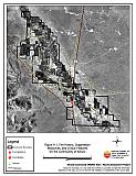
Schurz demonstrates the characteristics of an intermix wildland-urban interface condition. Structures are scattered throughout the wildland area with no clear line of demarcation between wildland fuels and the lands and buildings of the community. Approximately 40 percent of the buildings assessed are on lot sizes of less than one acre. Nine of the structures assessed are on lot sizes of greater than ten acres aside, the rest of the buildings are on lots of one to ten acres in size. Accordingly, structure spacing varies, with some structures clustered close together and others surrounded by sizeable expanses of vacant land (see Figure 9-1).
- Roads: US Highway 95 and US Highway 95 Alternate are the major transportation routes through Schurz. Both US Highway 95 and US 95 Alternate are paved and are at least 24 feet in width.
- Signage: Most streets have signs that are easily visible throughout the community, however there are some exceptions. Addresses were visible on less than half of the homes. Clear and visible residential addresses are important to aid fire fighting personnel in locating homes during low visibility conditions that may occur during a wildland fire.
- Utilities: Utilities are all above ground. Power line corridors have encroaching vegetation that could present a hazard if power lines arc during windstorms or other events.
9.1.2 Construction Materials
Approximately two-thirds of the homes in the interface are built with combustible siding materials. Many of these homes have siding made of medium-density fiberboard that will burn when exposed to high temperatures for a prolonged period of time. The minimal fuel load adjacent to most of these homes reduces the hazard of siding combustion.
Most of the homes have fire resistant roof materials such as composition roofing or metal. Only 44 of the 313 homes observed had unenclosed balconies, porches, decks or other architecture features that could create drafts and provide areas where sparks and embers can smolder and rapidly spread fire to the home.
9.1.3 Defensible Space
Nearly all of the homes have landscaping that would meet the minimum defensible space requirement to help protect the home from damage or loss during a wildfire. See the Defensible Space Guidelines and the Homeowner’s Annual Checklist in Appendix D for detailed information on defensible space.
9.1.4 Suppression Capabilities
Wildfire Protection Resources
Schurz is protected by the 18 member Walker River Volunteer Fire Department. Additional resources are available from the Mineral County Fire Department, Yerington Fire Department, Fallon Fire Department, DZHC Fire and Emergency Services at the Hawthorne Army Depot, and the Bureau of Indian Affairs. Table 9-1 lists the types of wildfire resources, cooperating partners and equipment available to Schurz in the event of a reported wildland fire.
| Response Time | Type of Resources | Amount | Cooperating Partner (Resource Location) |
|---|---|---|---|
| 10 - 30 minutes | Engine (750 gal. Type 2) Engine (1000 gal.) IC Vehicle |
1 1 1 |
Walker River VFD (Schurz) |
| 1 - 2 hours | Engine Water Tender Engine Engine Engine |
1 1 1 1 1 |
Mineral County FD (Hawthorne) Yerington FD (Yerington) Fallon FD (Fallon) DZHC Fire & Emergency Services (Hawthorne Army Depot) |
| 2+ hours | Air Tanker Water Tender Helicopter IC Commander Hand Crews |
1 1 1 1 1 |
BIA (Carson City) |
| Source: Personal communication with Chief Tad Williams, Walker River Volunteer Fire Department. | |||
Water Sources and Infrastructure
Water availability for fire suppression in Schurz include:
- Community wells
- 500 gpm hydrants within 1,000 feet of structures
- A water storage tank with 285,000-gallon capacity
- Weber Reservoir (helicopter dip site and drafting location)
The water system relies on gravity fed and electrical pumps. There is no backup emergency generator to run the pumps.
Detection, Communication
Fires are reported in the Schurz area through:
- 911
Fires are communicated to fire response personnel through the use of:
- Fire Dispatch through the Tribal Police Dispatch in Schurz
- Mineral County Fire Department at the Hawthorne Fire Station
- Radios using the following frequency: EMS and Fire-155.340; police-158.805
- Pager
Schurz has access to the State mutual aid frequencies and their system is compatible with neighboring agencies. There are gaps in radio coverage in the hills along the US Highway 95 Alternate.
Fire Protection Personnel Qualifications
All volunteer firefighters are trained to the State of Nevada entry-level firefighter qualifications. The Walker River VFD does not utilize the Red Card system for individual qualifications. A Red Card certification is part of a fire qualifications management system used by many state and all federal wildland fire management agencies that indicates an individual is qualified to fire wildland fires.
Work Load
The Walker River VFD responded to 207 calls in 2003
- Emergency Medical Calls: 170
- Wildland / Brush fire calls: 20
- Other calls: 17
Financial Support
Financial support for the Walker River VFD comes from grants and a minimal Tribal tax rate.
Community Preparedness
Schurz has a HazMat emergency plan, a disaster plan in case of a dam break at Weber Reservoir, and an emergency evacuation plan. The Tribal Chair is authorized to activate the emergency evacuation plan. The Walker River VFD does not review community development plans.
9.1.5 Factors Affecting Fire Behavior
The vegetation fuel density in the Schurz interface area is classified as moderate, and estimated to be approximately four to six tons per acre. The terrain is fairly flat with a north aspect, and winds are predominantly out of the west/southwest in the late afternoons. Fuels in the community consist primarily of Bailey’s greasewood, fourwing saltbush, rabbitbrush, and cheatgrass. Along the Walker River through the community there are stands of saltcedar (Tamarisk ramosisima) and willows (Salix sp.) intermixed with the greasewood and rabbitbrush. There are several unlined irrigation ditches that traverse the community, bounded by heavy willow and other plant vegetation.
Vegetation around the perimeter of the community is light consisting primarily of greasewood, shadscale, bud sagebrush, and cheatgrass. The fuel density in this area was estimated to be less than one-half ton per acre.
9.1.6 Fire Behavior Worst Case Scenario
The worst-case scenario for the community of Schurz would begin with a fire starting in the vegetation west of town along the Walker River on a high hazard day in mid summer. Prevailing winds would push the fire eastward into the community along the Walker River corridor. Fire spreading from the river through the sage and grasses could reach nearby structures. Vegetation in and along irrigation ditches could quickly draw fire into the community. Hay stacked in areas of high grasses or shrubs contributes to the fuel loading hazard.
9.1.7 Ignition Risk Assessment
The Risk Assessment resulted in assigning Schurz a moderate ignition risk rating. Ignition risks fall into two categories - lightning and human caused. There is some history of wildfire ignition to the west of Schurz, but no significant record of wildfire activity (see Figure 3-2).
Human caused ignitions can come from a variety of sources: fires started along highways and county roads from burning material thrown out of vehicle windows or ignited during auto accidents; off-road vehicles; railroads; arcing powerlines; agricultural fires; ditch burning; debris burning in piles or burn barrels; matches, and fireworks are a few examples of ignition sources for human caused wildfires.
Overhead power lines and the burning of irrigation ditches were identified by the assessment teams as items of special concern in the risk assessment for Schurz.
9.2 Risk and Hazard Reduction Recommendations, Roles, and Responsibilities
The responsibility to keep a community fire safe falls not only on the local fire department but also on the residents of the community, businesses, and local governments. The Schurz Risk Reduction Recommendations focus primarily on fuel reduction treatments along the Walker River corridor, defensible space and homeowner issues. Other recommendations pertain to community coordination and public education efforts that could be undertaken to enhance fire safety in Schurz. The recommendations are detailed below and summarized in Table 9-2.
9.2.1 Fuel Reduction Treatments
The following recommendations are general fuel reduction treatments should be implemented to reduce the potential fire hazard, or reduce the chance of wildfire spread across roadways or other man-made or natural barriers.
Walker River Paiute Tribe Responsibilities
- Thin the fuel load (willows and shrubs) on both sides of the Walker River throughout the community by removing dead wood and vegetation litter. Thin a minimum distance of 50 feet on both sides of the river. Thin a distance of 100 feet on both sides of the river in areas where the dense vegetation along the river corridor widens.
- Remove vegetation and debris in irrigation ditches to minimize the fuel build-up.
9.2.2 Defensible Space
Following are some general guidelines for improving defensible space around residences and structures in the community.
Property Owner Responsibilities
- Remove, reduce, and replace vegetation around homes according to the guidelines in Appendix D. This area should be kept:
- Lean: There are only small amounts of flammable vegetation,
- Clean: There is no accumulation of dead vegetation or other flammable debris,
- Green: Existing plants are healthy and green during the fire season.
- Maintain the defensible space condition as needed.
- Clear all vegetation and combustible materials around above ground fuel tanks for a minimum distance of 10 feet.
- Maintain the defensible space area free of all flammable native shrubs or invading annual vegetation. Use of a weed eater can effectively remove the green annual. It is important to rake and remove the cut material to eliminate the fire hazard.
- Prune trees so that branches are at least 15 feet away from chimneys and/or structures.
- Thin shrubs to a spacing equal to twice their height.
- Irrigate all remaining trees and large shrubs in close proximity to structures to increase their fire resiliency whenever possible. This is especially important during drought conditions.
- Remove or clean up abandoned structures.
Walker River Paiute Tribe Responsibilities
- Clear vegetation and maintain a minimum distance of 10 feet from the edge of secondary roadways.
Union Pacific Railroad Responsibilities
- Clear vegetation and maintain a minimum distance of 15 feet from all railroad tracks.
Utility Company Responsibilities
- Clear a space no less than 15 feet from electric utility infrastructure within powerline corridors. Maintain this area free of accumulated vegetative fuels.
9.2.3 Community Coordination
Walker River Volunteer Fire Department Responsibilities
- Ensure that burning permits and associated requirements are enforced during irrigation canal burning. If no requirements are in place, develop and adopt burning permit requirements to only permit fires on minimal hazard days. A sample burn permit is included in Appendix E.
- Fire Department should work with homeowners to identify any non-ambulatory persons within the community for evacuation assistance.
- Obtain a wildland fire engine. Investigate grants, federal and state excess property programs, and other fire departments for a possible engine purchase at a reduced cost.
Walker River Paiute Tribe Responsibilities
- Post addresses for visibility from roads. The best location is where private driveway and road intersect. Address characters should be at least four inches tall and reflective.
- Require that all future development on the reservation meets the National Fire Protection Association codes and standards with regards to structure construction, road construction, and water supply systems. Initiate Tribal review existing planning guidelines and revise as needed to meet the minimum requirements outlined in Appendix E for fire safe communities.
Property Owner Responsibilities
- Form a local chapter of the Nevada Fire Safe Council. The Nevada Fire Safe Council proposes to work on solutions that reduce the risk of loss of lives and property from wildfires in Nevada’s communities. Through the establishment of a local Chapter, communities become part of a large information-sharing network that receives notifications of programs and funding opportunities for fire mitigation projects such as those listed in this report. The Nevada Fire Safe Council will accept and manage grants and contracts on the Chapter’s behalf through its non-profit status. The Nevada Fire Safe Council provides assistance and support to communities to complete fire safe plans, set priorities, educate and train community members and promote success stories of its members. For more information on forming a chapter, contact:
Nevada Fire Safe Council
1187 Charles Drive
Reno, Nevada 89509
(775) 322-2413
www.nvfsc.org
9.2.4 Public Education
Public education about how to become more fire safe is critical in all communities. Informed community members will take the initiative required to lead efforts of a scale sufficient to effectively reduce the threat that wildland fires present to the entire interface community.
Walker River Volunteer Fire Department Responsibilities
- Distribute copies of the publication “Living with Fire” to all property owners. This publication is free of charge. Copies can be requested from the University of Nevada Cooperative Extension, (775) 784-4848.
9.3 Summary of Recommendations
| Responsible Party |
Recommendation Description |
|---|---|
| Property Owners | Remove, reduce, and replace vegetation around homes according the defensible space guidelines in Appendix D. Maintain defensible space. Clear all vegetation and combustible materials around above ground fuel tanks for a minimum distance of 10 feet. Prune trees so that branches are at least 15 feet away from chimneys and/or structures. Thin shrubs to a spacing equal to twice their height. Irrigate all remaining trees and large shrubs in close proximity to structures to increase their fire resiliency. Remove or clean up abandoned structures. Form a local chapter of the Nevada Fire Safe Council. |
| Walker River Paiute Tribe | Thin the fuel load (willows and shrubs) on both sides of the Walker River throughout the community by removing dead wood and vegetation litter. Remove vegetation and debris in irrigation ditches to minimize the fuel build-up. Clear vegetation and maintain a minimum distance of 10 feet from the edge of secondary roadways. Post addresses for visibility from roads. Best location is where private driveway and road intersect. Address characters should be at least four inches tall and be fire-resistant. Require all future development to meet the National Fire Protection Association code and standards with regard to structures, road construction, and water supply. (See Appendix E for fire safe community recommendations for planning new developments.) |
| Union Pacific Railroad | Clear and maintain free of vegetation a minimum distance of 15 feet from all railroad tracks. |
| Utility Company | Clear and maintain free of vegetation a minimum distance of 15 feet from power line corridors. |
| Walker River VFD | Ensure that burning permits and associated requirements are enforced during irrigation canal burning. If no requirements are in place, develop and adopt burning permit requirements to only permit fires on minimal hazard days. A sample burn permit is included in Appendix E. Fire Department should work with homeowners to identify any non-ambulatory persons within the community for evacuation assistance. Obtain a wildland fire engine. Check into grants, federal and state excess property programs, and other fire departments for a possible engine purchase at a reduced cost. Distribute copies of the publication “Living with Fire” to all property owners. |
Figure 9-1Fire History, Suppression Resources, and Critical Features for the Community of Schurz. |
 |
Table 9-3Schurz Wildfire Hazard Ratings Summary |
 |