![]()
![]()
12.0 Manhattan
12.1 Risk and Hazard Assessment
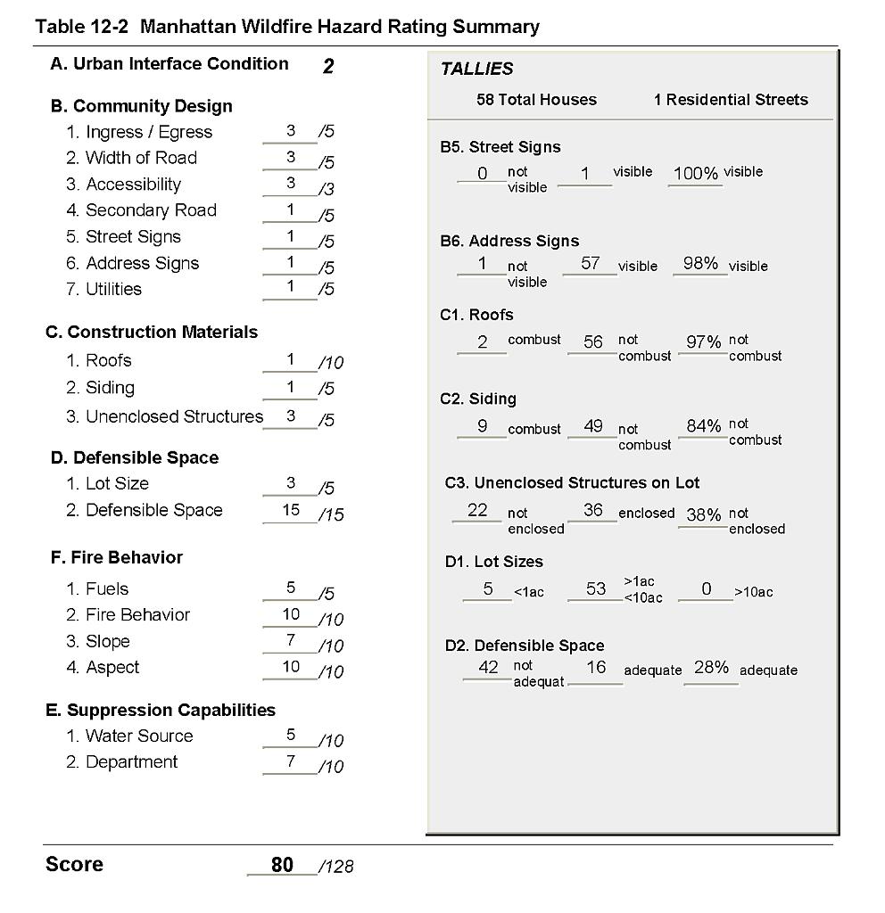
Manhattan is an old mining community situated at 7,000 feet in elevation at the south end and west side of the Toquima Range in northern Nye County. The town population is estimated at 135 people. The assessment resulted in classifying Manhattan in the Extreme Community Hazard category (80 points). The fire hazard rating was primarily attributed to limited access, inadequate defensible space, and potential for extreme fire behavior based on heavy fuels, steep topography, and west facing slopes. A summary of the values that contribute to this hazard rating is included in Table 12-2.
12.1.1 Community Design
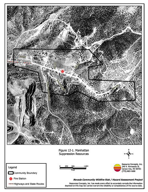
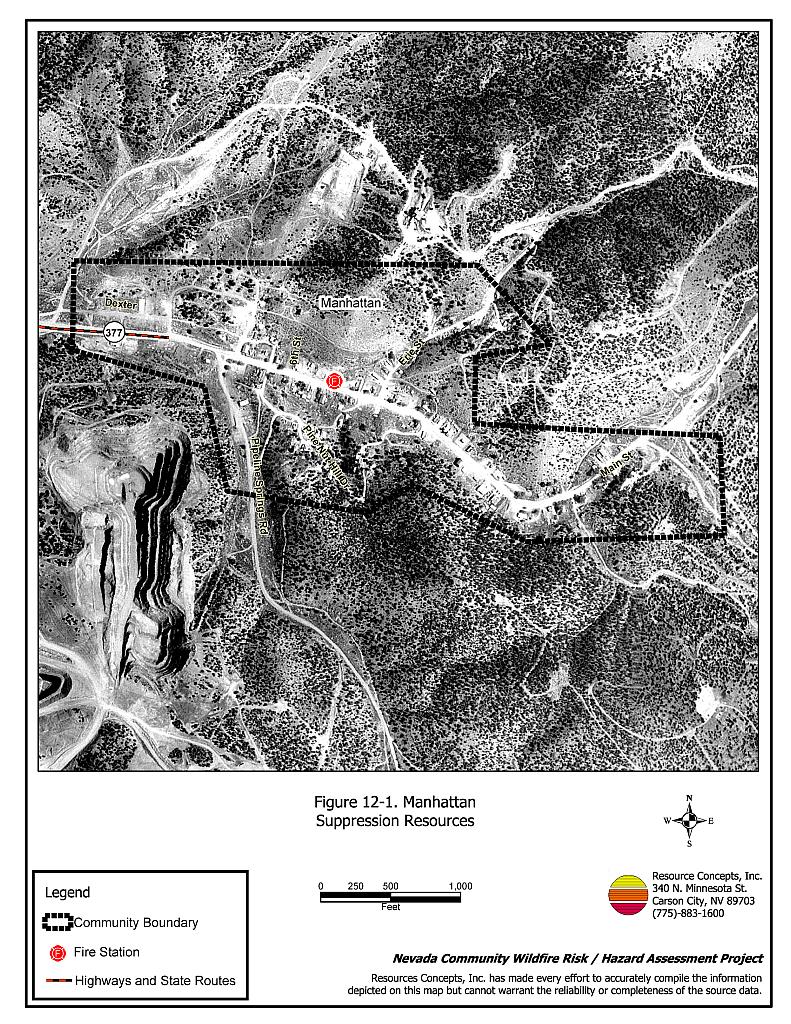
Manhattan is characterized as an intermix wildland-urban interface condition: structures are scattered throughout the wildland area with no clear line of demarcation between wildland fuels, buildings, and open space throughout the community. All but five of the 58 houses observed were on parcels between one and ten acres in size; five parcels were less than one acre in size (Figure 12-1).
- Roads: The only access into the community is State Route 377, which becomes Main Street. This dirt road is between twenty and 24 feet wide. Many of the roads in the community are steeper than a five percent grade, although the majority of the roads have adequate turnaround space for fire suppression equipment.
- Signage: The one primary street in town had a clearly visible sign. All but one of the 58 homes had clear address signs. Clear and visible signage is important to assist fire suppression personnel locate residences during poor visibility conditions that may occur during a wildland fire.
- Utilities: All of the utilities were above ground. The majority of the power line corridors had been properly maintained to minimize wildfire damage to electric utilities and reduce the possibility that sparks created by electric utilities would start a fire in adjacent vegetation.
12.1.2 Construction Materials
Eighty-four percent of the currently inhabited homes observed in the interface area were built with ignition resistant, treated, wood siding materials. All but two of the homes had fire resistant roofing materials such as composition roofing, metal, or tile. Many old, abandoned buildings with tarpaper roofs are scattered throughout the community. Thirty eight percent of the homes observed had unenclosed balconies, porches, decks, or other architectural features that can create drafty areas where firebrands can accumulate, smolder, and ignite, rapidly spreading fire to the home.
12.1.3 Defensible Space
Few of the homes observed (28 percent) met the minimum recommended defensible space guidelines for landscaping to help protect the home from damage or loss during a wildfire.
12.1.4 Suppression Capabilities
Wildfire Protection Resources
The Manhattan Volunteer Fire Department reported one fire station staffed by 25 volunteers. Table 12-1 lists the types of wildfire resources, cooperating partners, and equipment available to Manhattan in the event of a reported wildland fire. In addition to the current equipment, in 2004 the Nye County Commissioners approved the purchase of a four-wheel drive emergency vehicle equipped with a 2,000-gallon water tank and a 1,000 gpm pump for the Manhattan Volunteer Fire Department.
| Type of Equipment | Amount of Equipment | Cooperating Partner (Resource Location) |
|---|---|---|
| Type 6 Brush Truck Type 2 Engine Type 3 Engine |
1 1 1 |
Manhattan Volunteer Fire Department (Manhattan) |
| Type 1 Engine Type 6 Brush Truck |
1 1 |
Round Mountain Volunteer Fire Department (Hadley) |
| Water Tender | 1 | Smoky Valley Volunteer Fire Department (Carvers) |
| Source: Personal conversation with Chief Dennis Floto, Manhattan VFD, (June, 29 2004) | ||
Additional resources are available through fire departments in Hadley and Tonopah, dispatched through the Nye County Sheriff Department, and the Nevada Division of Forestry Tonopah Conservation Camp, as dispatched through the Sierra Front Interagency Dispatch Center. The Bureau of Land Management and US Forest Service resources are dispatched through the Central Nevada Interagency Dispatch Center. It is important to note that the actual number and type of suppression resources available to respond from neighboring fire departments and agencies is dependent upon the resources on hand at the time of the wildland fire call.
Water Sources and Infrastructure
There are fire hydrants scattered throughout the community but not all structures were protected. The hydrants are fed by a 36,000-gallon water storage tank. Gravity and electric pumps power the water system but do not meet the 500-gallon per minute flow rate described in the Uniform Fire Code. No backup generator was available for the well pumps at the time of the interview.
Detection and Communication
Fires are reported by calling 911. Fires are communicated to fire response personnel through the use of radios and pagers by the Nye County Sheriff Department in Tonopah. Manhattan also has a community siren.
The radio frequency is compatible with neighboring agencies and the fire department has access to state mutual aid frequencies. Many gaps in radio coverage were reported throughout the area due to the steep terrain.
Fire Protection Personnel Qualifications
Nye County Emergency Services provided training to the volunteer firefighters. The training focused on structure protection and touched on wildland fire suppression.
Work Load
The Manhattan Volunteer Fire Department responded to one wildland/brush fire in 2003.
Financial Support
Financial support for the Manhattan Volunteer Fire Department comes from the Nye County General Fund and the Manhattan Volunteer Fire Department annual fundraiser.
Community Preparedness
The Nye County Local Emergency Planning Committee maintains an Emergency Plan for hazardous materials and an All Risk County Plan. The Nye County Sheriff Department has an evacuation plan for disasters.
Manhattan formed a chapter of the Nevada Fire Safe Council in April 2003. Through the establishment of a local chapter, Manhattan obtained access to information and funding to implement a fuelbreak on approximately twenty acres of private land to the south of the community. The successful completion of this project has provided a model for cooperative projects involving private and federal lands (B. Bottom, pers. comm., December 1, 2004).
12.1.5 Factors Affecting Fire Behavior
Vegetation, dead and down fuels, and topographic features contribute to the potential fire hazard in the wildland-urban interface. Manhattan lies in a narrow canyon with steep slopes on each side, ranging between twenty and thirty percent. The predominant aspect is to the south. North winds associated with passing cold fronts or thunderstorm activity are common, particularly in the summer afternoons. Prevailing wind exposure and ladder fuels may inhibit effective suppression efforts.
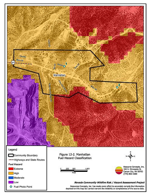
Moderate to heavy fuels ranging from six to thirty tons per acre surround the town. The overall interface fuel hazard condition was rated as high to extreme. (See Figures 12-2 and 12-3). The fuels are composed of pinyon and juniper with a shrub understory of rabbitbrush, bitterbrush, and sagebrush. Shrubs are typically two to four feet tall. Ground fuels include cheatgrass and perennial grasses. Continuous dense fuels in close proximity to structures, numerous old wooden structures (many of which are abandoned) and inadequate defensible space constitute a serious fuel hazard in Manhattan.
12.1.6 Fire Behavior Worst-case Scenario
The worst-case scenario would begin during an above normal precipitation year with above normal grass production. A fire started in the late afternoon located west to southwest of the community could be pushed by strong winds up the canyon through heavy fuels. There is a high potential for extreme fire behavior due to steep slopes, poor defensible space, and many old wooden structures. Long range spotting of up to one-quarter mile could occur creating multiple fire fronts. Flame lengths of six to twenty feet with rates of spread of thirty to 75 feet per minute could be expected. There are limited suppression resources within the community and additional suppression resources are a minimum of thirty minutes away. Fire could easily escape initial attack.
12.1.7 Ignition Risk Assessment
Manhattan has a high risk of ignition due to heavy fuels within the community. The primary ignition sources are lightning and off-road vehicles. Two fire ignitions were recorded within six miles of Manhattan, the five-acre Peavine fire in 1985 and another small fire in 1992.
12.2 Previous Site Assessment Summary
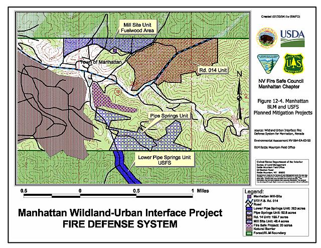
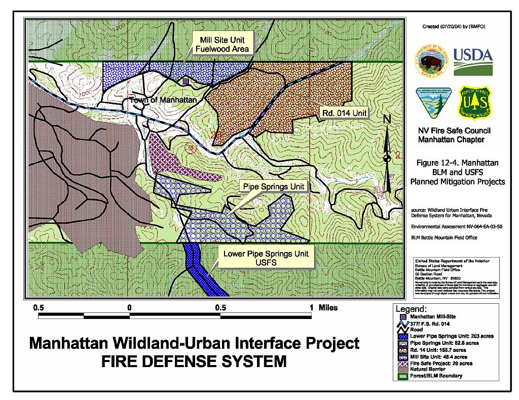
The Bureau of Land Management conducted a community assessment of Manhattan in October 2002 and completed an environmental assessment in November 2003. The BLM recommended shaded fuelbreaks on 487 acres of public and national forest and lands (D. Walker, pers. comm. 2 December 2004). Implementation of this interagency effort was initiated during the summer of 2004.
Treatments focused on removing dead and diseased trees in the project areas, with final tree spacing projected to be approximately thirty feet between crowns. Additionally, trees were being limbed to three feet above the ground. These treatments were reported to be underway in a 200-foot wide corridor along Pipe Spring Road and on approximately 83 acres in the Pipe Springs Unit (B. Bottom, pers. comm. 01 Dec 2004). During phase II, which is projected to follow the tree thinning and pruning, shrubs greater than one foot in height within ten feet of the tree canopies will be reduced to one foot in height or less. Treatment areas are shown in Figure 12-4.
In addition to these interagency efforts, in 2001 a fuelbreak was constructed on approximately twenty acres of private land to the south of the community using matching funds from the landowner and the Nevada Fire Safe Council.
12.3 Risk and Hazard Reduction Recommendations, Roles, and Responsibilities
The following risk and hazard reduction recommendations for Manhattan address the primary concern regarding defensible space. Other recommendations pertain to community coordination and public education efforts that could be initiated to improve fire safety in Manhattan.
12.3.1 Defensible Space Treatments
Defensible space treatments are an essential first line of defense for residential structures. The goal of the treatment is to significantly reduce or remove vegetation within a prescribed distance from structures. (Specific guidelines for defensible space are dependent on fuel type and topography and are given in Appendix E.) Defensible space reduces fire intensity and decreases the potential for loss or damage to structures in the event of an oncoming wildfire.
Property Owner Responsibilities
- Remove, reduce, and replace vegetation around homes according to the guidelines in Appendix E. This area should be kept:
- Lean: There are only small amounts of flammable vegetation,
- Clean: There is no accumulation of dead vegetation or other flammable debris, and
- Green: Existing plants are healthy and green during the fire season.
- Maintain the defensible space condition as needed.
- Immediately remove cleared vegetation to an approved disposal site when implementing defensible space treatments. This material dries quickly and presents a fire hazard if left on site.
- Where cheatgrass has become dominant within the defensible space zone, areas should be mowed prior to seed set, or treated with an application of a pre-emergent herbicide. Prescribed treatments may need to be repeated for several years to ensure that the bank of unwanted annual plants seeds has been depleted. Refer to Appendix E for a recommended seed mixture and planting guidelines that can be used in conjunction with cheatgrass removal.
- Clear around propane tanks for a minimum distance of ten feet and maintain this area free of accumulated vegetation and combustible materials.
- Remove flammable materials and other debris from the defensible space area.
- Store lumber, firewood, and other flammable materials a minimum distance of thirty feet from structures.
- Install spark arrestors on chimneys.
- Maintain the area beneath wood decks and porches free of weeds and flammable debris. Enclose these areas where possible.
- If a resident decides to keep some pinyon or juniper trees near the home for aesthetic reasons, no other native trees or ladder fuels should be within a minimum of thirty feet of the crown of the tree.
- Trim tree limbs to a height of four feet above the ground (but not more than one-third of the tree canopy). Pinyon pines should be thinned to a spacing of one and one-half times the height of the trees from the edge of the tree crowns.
- Prune tree branches to at least fifteen feet from chimneys, walls, and roofs of structures.
- Remove or properly enclose trailers and buildings that have been abandoned to prevent unwanted ignition from sparks or firebrands.
- Mow or remove brush, weeds, and other flammable vegetation growing against wood fences in the community.
- Replace wood roofs with non-combustible roofing materials such as composite shingles or metal.
12.3.2 Fuel Reduction
Fuel reduction treatments are applied on a larger scale than defensible space treatments. By permanently changing the fuel structure over large blocks of a land to one of lower volume or reduced flammability with a fuel reduction treatment, the expected result in the event of a catastrophic wildfire would be one of reduced capacity for uncontrolled spread through the treated area.
Property Owner Responsibilities
- Remove brush and trees within twenty feet of each sides of private driveways longer than 200 feet. Replace flammable fuels with fire-resistant species such as crested wheatgrass or an approved pre-suppression seed mix. Refer to Appendix E for approved seed mixes, planning guidelines, and seed sources.
Manhattan Volunteer Fire Department Responsibilities
- Mow or otherwise remove all vegetation within ten feet of all fire hydrants to improve visibility and access for fire personnel.
Utility Company Responsibilities
- Remove rather than prune trees in the power line right-of-ways.
- Clear vegetation and maintain a space of no less than fifteen feet around utility poles.
BLM and USFS Responsibilities
- Continue implementation of fuel reduction treatments as described in the BLM site assessment and environmental assessment.
12.3.3 Community Coordination
Coordination among local, state, and federal fire suppression agencies is important in the day-to-day fire prevention activities and becomes critical in the event of a wildland fire.
Manhattan VFD Responsibilities
- Participate annually with the Bureau of Land Management and the US Forest Service to discuss pre-attack plans for the community.
- Provide pre-attack plans, including maps of water sources, staging areas, safety zones, etc. to outside agencies that respond to a wildfire event.
- Work with the County to upgrade the repeater system and improve radio communications with Nye County Sheriff’s dispatch.
Nye County and Manhattan VFD Responsibilities
- Prepare an evacuation plan and post, or otherwise distribute this plan to residents. This plan should include information regarding evacuation routes, evacuation procedures, designated fire safe zones, and procedures for sheltering in place in case evacuation becomes infeasible during a fast moving firestorm.
Property Owner Responsibilities
- As an evacuation plan becomes available, read and become fully knowledgeable of evacuation procedures, fire safety zones, and safety procedures for sheltering in place in the event that evacuation is not possible.
12.3.4 Public Education
Public education focused on increasing community fire safety is critical. A program that explains fire safe measures in clear and emphatic terms will have an impact on residents in the wildland-urban interface. Informed community members will be more inclined to take actions to effectively reduce fuels and other wildfire hazards around their homes and in their neighborhoods.
Manhattan VFD Responsibilities
- Contact the BLM Battle Mountain Field Office and the University of Nevada Cooperative Extension for assistance with programs for public education.
- Distribute copies of the publication “Living with Fire” to all property owners. This publication is free of charge. Copies can be requested from the University of Nevada Cooperative Extension.
12.3.5 Equipment and Training
Resources and training for wildfire is a safety issue for firefighters as well as the community. The volunteer fire department needs brush training and equipment to safely do their job.
Manhattan VFD Responsibilities
- Seek funding to provide personal protection equipment for wildland firefighting. Personal protection equipment includes hard hats, goggles, gloves, fire shelters with cases, and Nomex clothing.
- Obtain wildland firefighting equipment such as Pulaskis, shovels, and McLeods.
- Coordinate with the Bureau of Land Management and US Forest Service to ensure that radio frequencies and radios are compatible in order to maintain communications during wildland fire incidents.
- Continue to provide basic wildland firefighter training through annual attendance at a BLM Wildland Firefighter Training for volunteer firefighters or other training opportunities.
- Ensure that wildfire training and equipment conforms to the National Wildfire Coordinating Group 310-1 standards.
Nye County Responsibilities
- Upgrade the repeater system to improve radio communications between Nye County Sheriff’s Dispatch and the Manhattan Volunteer Fire Department.
- Assist the Volunteer Fire Department in securing grants to obtain wildland firefighting equipment.
Figure 12-1Manhattan Suppression Resources |
 |
Figure 12-2Manhattan Fuel Hazard Classification |
 |
Figure 12-3. Manhattan Fuel Hazard Photo Points

Photo Point 1. N 4265626 E 493710 130°SE. Pinyon and juniper vegetation dominates the hillsides around the community. Vegetative fuel loads were estimated at eight tons per acre for high hazard sagebrush and rabbitbrush fuel types and approximately thirty tons per acre in the extreme hazard pinyon and juniper fuel type.
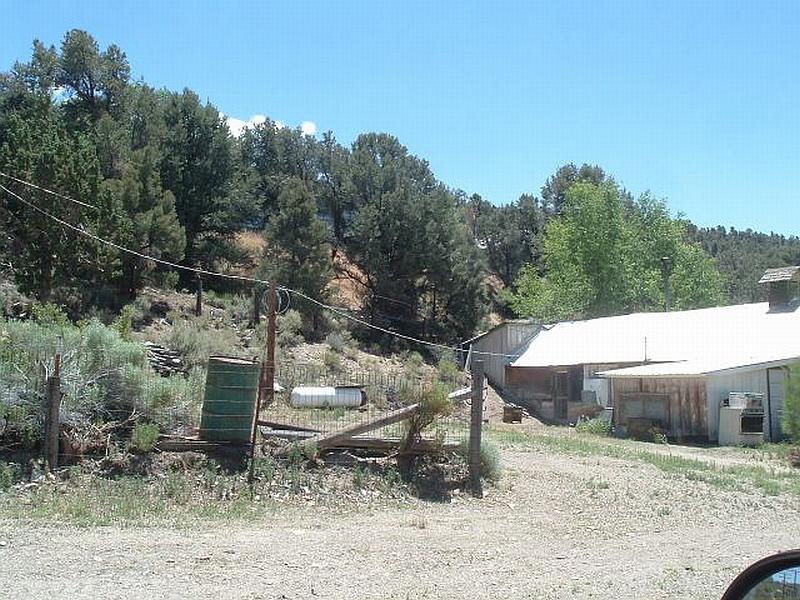
Photo Point 2. N 4265385 E 494317 170°SSE. In many cases, a minimum of 100 to 200 feet of vegetation clearance is needed to create the defensible space appropriate for protecting structures in Manhattan.
Figure 12-4Manhattan BLM and USFS Planned Mitigation Projects |
 |
Table 12-2Manhattan Wildfire Hazard Rating Summary |
 |