![]()
![]()
3.0 Description Of The County
3.1 Demographics, Location, Topography, and Climatic Data
Washoe County is in the northwest corner of Nevada bordering California to the west and Oregon to the north. Washoe County encompasses approximately 4.2 million acres. The population for Washoe County was estimated at 365,433 persons (US Census Bureau 2003) The Nevada Department of Employment, Training, and Rehabilitation reported trade, transportation, and utilities; leisure and hospitality; and government as the major employers in Washoe County (Nevada Commission on Economic Development, 2004).
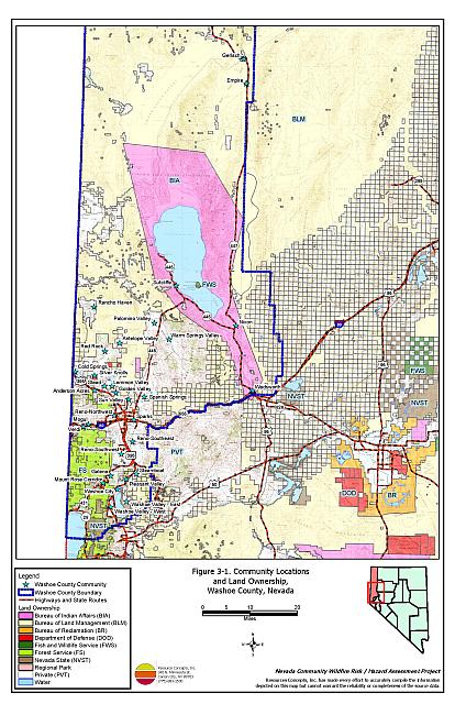
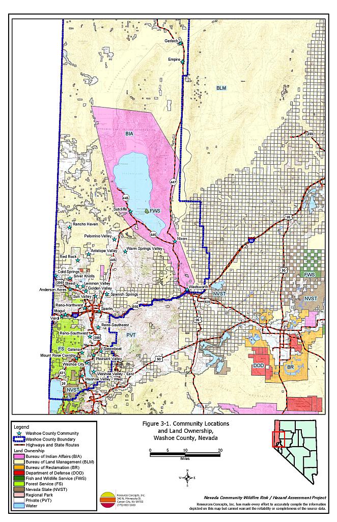
The majority of land within Washoe County is public land administered and managed by the Bureau of Land Management. The federal agency policies and decisions on public lands adjacent to the wildland-urban interface areas have direct effects on private landowners within the county. The Pyramid Lake Indian Reservation encompasses approximately 470,000 acres in the southeastern part of Washoe County. The largest water bodies in Washoe County include Pyramid Lake and the Truckee River. The most extensive urban area in Washoe County is located in the southwest portion of the county and includes many individual communities. The northern half of the County is primarily undeveloped and includes a large portion of the Sheldon National Wildlife Refuge. A jurisdictional summary of land management administration is provided in Table 3-1 and presented on Figure 3-1.
| Land Administrator | Approximate Acreage | Percent of county |
|---|---|---|
| Federal | ||
| Bureau of Land Management | 2,681,093 | 60 |
| US Forest Service | 94,581 | 3 |
| Bureau of Indian Affairs | 356,088 | 9 |
| Bureau of Reclamation | 283 | <1 |
| Department of Defense | 1,732 | <1 |
| US Fish and Wildlife Service | 175,360 | 5 |
| State of Nevada | ||
| State of Nevada | 15,966 | <1 |
| Private / Local Government | ||
| Regional Park | 559 | <1 |
| Private | 712,257 | 19 |
| Other | ||
| Water | 154,858 | 4 |
| Source: Bureau of Land Management land ownership GIS database. | ||
Elevations within the County range from approximately 3,760 feet at Winnemucca Lake, a dry lakebed in eastern Washoe County, to 10,776 feet at Mt. Rose in the Carson Range. The most prominent mountain range is the Carson Range of the Sierra Nevada Mountains on the west side of the county along the California border. Other major mountain ranges and features in close proximity to at risk communities in Washoe County include Peavine Peak, Virginia Range, Petersen Mountain, Pah Rah Range, and Fred’s Mountain.
Climatic thirty-year averages for Reno (at Reno-Tahoe International Airport) indicate average high/low temperatures range from 45°F/28°F in January to 91°F/51°F in July. Average annual precipitation in Reno is 7.5 inches with precipitation reaching twenty inches or more in higher elevation communities such as Incline Village (Western Regional Climate Center website). The majority of the precipitation received in Washoe County arrives in the form of snow during the winter months with rain also occurring in the early spring. The summer and fall months are relatively dry with isolated thunderstorms providing the precipitation during these months. Dry lightning storms coupled with periodic drought conditions poses a high ignition risk to many communities in Washoe County.
Mountain valley wind patterns, particularly on the east side of the Sierra Mountains, strongly influence fire behavior in parts of Washoe County. Local daily wind patterns down the east-facing canyons and valleys are influenced by differential heating and cooling on east and west facing slopes. Afternoon downslope winds and cross valley winds can frequently exceed 20 miles per hour (American Meteorological Society Glossary of Meteorology).
3.2 Wildfire History
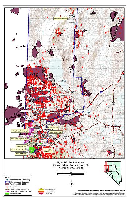
There is a history of many large wildfire occurrences between 1980 and 2003 in Washoe County (Nevada Bureau of Land Management State Office 2002). During the last two decades, approximately eight percent of Washoe County burned in wildland fires. Table 3-2 summarizes the fire histories and fire ignitions by year that have been reported to the database. Figure 3-2 illustrates the large fire history and fire ignitions on a map of Washoe County. The largest fire recorded in the county occurred in 1999 and burned approximately 47,663 acres northeast of the Rancho Haven community.
| Year | Number of Fire Ignitions | Total Fire Acreage |
|---|---|---|
| 1980 | 19 | Not Available |
| 1981 | 12 | 10,728 |
| 1982 | 16 | 69 |
| 1983 | 28 | 9,634 |
| 1984 | 50 | 32,167 |
| 1985 | 39 | 55,470 |
| 1986 | 29 | 1,060 |
| 1987 | 40 | 251 |
| 1988 | 37 | 3,213 |
| 1989 | 9 | 15 |
| 1990 | 57 | 1,430 |
| 1991 | 48 | 107 |
| 1992 | 43 | 688 |
| 1993 | 11 | 15 |
| 1994 | 17 | 2,546 |
| 1995 | 15 | 3,265 |
| 1996 | 34 | 17,395 |
| 1997 | 29 | 1,852 |
| 1998 | 16 | 5,802 |
| 1999 | 25 | 93,559 |
| 2000 | 37 | 32,454 |
| 2001 | 32 | 30,234 |
| 2002 | 42 | 980 |
| 2003 | 24 | 2,197 |
| Unknown | 11 | Not Available |
| TOTAL | 720 | 305,131 |
| Source: Fire history data provided by the National Interagency Fire Center, Boise, Idaho. Fire acreage is derived from Bureau of Land Management and US Forest Service fire perimeter data and specific to acreage within Washoe County. | ||
3.2.1 Ignition Risk Factors
Wildfire ignition risks fall into two categories: lightning and human caused. Human caused ignitions can come from a variety of sources such as burning material thrown out of vehicle windows or ignited during auto accidents, off-road vehicles, railroads, arcing power lines, agricultural fires, campfires, debris burning in piles or burn barrels, matches, and fireworks. In Washoe County, database records indicate that of the 720 recorded fire ignitions, 455 were due to lightning, 145 were due to human causes, and 120 ignitions had causes that were not reported.
3.2.2 Fire Ecology
The science of fire ecology is the study of how fire contributes to plant community structure and species composition. A “fire regime” is defined in terms of the average number of years between fires under natural conditions (fire frequency) and the extent to which dominant vegetation is replaced by fire (fire severity). Natural fire regimes have been affected throughout most of Nevada by twentieth century fire suppression policies. Large areas that formerly burned with high frequency but low intensity (fires more amenable to control and suppression) are now characterized by large accumulations of unburned fuels, which once ignited, will burn at higher intensities.
Big sagebrush is the most common plant community in Nevada with an altered fire regime, now characterized by infrequent, high-intensity fires. Sagebrush requires ten to twenty or more years to reestablish on burned areas. During the interim these areas can provide the conditions for establishment and spread of invasive species and in some cases inhibit sagebrush reestablishment. The most common invasive species to reoccupy burned areas in northern Nevada is cheatgrass.
Effect of Cheatgrass on Fire Ecology
Cheatgrass is a common introduced annual grass that aggressively invades disturbed areas, especially burns. Replacement of a native shrub community with a pure stand of cheatgrass increases the susceptibility of an area to repeated wildfire ignitions, especially in late summer when desiccating winds and lightning activity are more prevalent. The total height and volume of cheatgrass fuel produced each year is highly variable and dependent on winter and spring precipitation. In years with above normal precipitation cheatgrass will produce much higher volumes of highly flammable fuels and can fully occupy interspaces between shrubs. As the grass matures and dries, a continuous and receptive fuel bed is created that is capable of rapidly burning into adjacent cover types that may be characterized by more severe and hazardous fire behavior. The ecologic risk of a fire spreading from a cheatgrass stand into adjacent, unburned native vegetation is that additional disturbed areas are thereby opened and vulnerable to cheatgrass invasion. Associated losses of natural resource values such as wildlife habitat, soil stability, and watershed functions are additional consequences.
Eliminating, or at least controlling cheatgrass presents a difficult challenge. Mowing defensible space and fuelbreak areas each year before seed maturity is effective in reduction cheatgrass growth. In areas where livestock may be utilized, implementing early season intensive grazing up to and during flowering may aid in depleting the seed bank and reduce the annual fuel load (BLM 2003, Davison and Smith 2000, Montana State University 2004). The use of pre-emergent herbicides has also proven effective in reducing growth and depleting the seed bank. Any herbicide treatment on public lands must be done in accordance with federal guidelines. Private landowners should proceed with caution if using herbicides, comply with all label instructions, and consult their local extension specialist prior to use.
Fire Ecology in Pinyon-Juniper Woodlands
Single-leaf pinyon and Utah juniper are the dominant components of a plant community commonly referred to as pinyon-juniper (P-J). P-J woodlands were primarily confined to the steeper slopes commonly found at higher elevations in the Great Basin prior to European settlement. These woodland communities were characterized by a discontinuous distribution on the landscape and a heterogeneous internal fuel structure; a mosaic pattern of shrubs and trees resulting from the canopy openings created by small and frequent wildfires.
Both pinyon and juniper trees have relatively thin bark with continuous branching all the way to the ground. In denser stands, lower tree branches frequently intercept adjacent ladder fuels, e.g. shrubs, herbaceous groundcover, and smaller trees. This situation creates a dangerous fuel condition where ground fires can be carried into tree canopies and create crown fires. A crown fire is the most perilous of all wildfire conditions and is usually catastrophic in nature since the danger to firefighters is generally too great to deploy ground crews.
Over the last 100 years, wildfires in most of the western United States have been aggressively suppressed and P-J woodlands have encroached over areas traditionally occupied by other plant communities. Tree canopy coverage has been greatly expanded and has reached as high as sixty percent or more in some areas, contributing to the loss of diverse shrublands. These dense woodlands are perceived as being desirable for urban expansion in contrast to the surrounding deserts. In areas where human occupation in P-J woodlands has grown over the last fifty years, the option of returning to a natural fire regime becomes increasingly problematic.
Fire Ecology in Jeffrey Pine and Mixed Coniferous Forests
Some plant communities have evolved to burn frequently with low intensity, for example mature Jeffrey pine forests. Under a natural fire regime, low-intensity surface fires reduce fuel loading from grasses and shrubs, suppress regeneration of shade-tolerant white fir seedlings, and leave the adult Jeffrey pine trees unaffected, protected by thick, fire-resistant bark. Forests with frequent fire occurrence often have an open, “park-like” appearance with an understory of grass or low shrubs. Though shaded by large, mature trees, spacing between trees is sufficient to allow sunlight to reach the forest floor and encourage regeneration of shade-intolerant species like Jeffrey pine trees. Pockets of heavy fuels exist in these conditions, but their discontinuous nature reduces the likelihood that a fire will burn with enough intensity to negatively impact mature trees. In the absence of frequent surface fires, accumulated dead-and-down woody fuels and the green “ladder fuels” can carry flames into the coniferous overstory, potentially provoking a catastrophic, stand-destroying crown fire.
3.3 Natural Resources and Critical Features Potentially at Risk
Critical features at risk of loss during a wildfire event can be economic assets such as agricultural and industrial resources or cultural features such as historic structures, archaeological sites, and recreation-based resources.
3.3.1 Historical Resources
The potential for adverse effects to historic resources depends upon site-specific factors that vary from place to place including the surrounding fuel hazard conditions, topography, and building materials. The five sites listed on the National Register of Historical Places for Washoe County, two of which are also listed on the Nevada Register of Historic Places, that could potentially be affected by wildland fire are summarized in Table 3-3.
| Site Name | Location | Source Register |
|---|---|---|
| Alamo Ranch House | Steamboat | National Register of Historic Places Nevada Register of Historic Places |
| Bowers Mansion | Washoe Valley | National Register of Historic Places Nevada Register of Historic Places |
| Brown, Peleg, Ranch AKA Damonte Ranch | Old Virginia Road, Reno | National Register of Historic Places |
| Walter Cliff Ranch | Washoe Valley | National Register of Historic Places |
| Gerlach Water Tower | Gerlach | National Register of Historic Places |
3.3.2 Flora and Fauna
There are three fish, one bird, one insect, and one plant in Washoe County listed as threatened or endangered under the Endangered Species Act. Several additional species are listed as sensitive by Nevada State legislation under Nevada Revised Statute 501 and 527 with potential habitat in Washoe County. Federal and State-listed species with potential or known occurrence in Washoe County are identified in Table 3-4. The Nevada Natural Heritage Program, the Nevada Division of Forestry, and the Nevada Department of Wildlife should be consulted regarding specific concerns and potential mitigation to minimize impacts to these species prior to implementing fuel reduction projects and prior to the occurrence of a catastrophic wildfire. Project recommendations involving federally listed, threatened or endangered species require formal consultation with the US Fish and Wildlife Service.
| Common Name | Scientific Name | Legislation |
|---|---|---|
| Plants | ||
| Steamboat buckwheat | Eriogonum ovalifolium var. williamsiae | ESA listed threatened; NRS 527.260 - .300 |
| Webber ivesia | Ivesia webberi | NRS 527.260 - .300 |
| Sand cholla | Opuntia pulchella | NRS 527.060 - .120 |
| Washoe Pine | Pinus washoensis | NRS 527.060 - .120 |
| Williams’ combleaf | Polyctenium williamsiae | NRS 527.260 - .300 |
| Tahoe yellowcress | Rorippa subumbellata | ESA candidate species NRS 527.260 - .300 |
| Mammals | ||
| Mono Basin mountain beaver | Aplodontia rufa californica | NRS 501 |
| Pygmy rabbit | Brachylagus idahoensis | NRS 501 |
| Spotted bat | Euderma maculatum | NRS 501 |
| American marten | Martes americana | NRS 501 |
| Insects | ||
| Carson wandering skipper | Pseudocopaeodes eunus obscurus | ESA listed endangered |
| Fishes | ||
| Warner sucker | Catostomus warnerensis | ESA listed threatened |
| Cui-ui | Chasmistes cujus | ESA listed endangered; NRS 501 |
| Lahontan cutthroat trout | Oncorhynchus clarki henshawi | ESA listed threatened; NRS 501 |
| Warner Valley redband trout | Oncorhynchus mykiss pop | NRS 501 |
| Birds | ||
| Northern goshawk | Accipiter gentilis | NRS 501 |
| Western burrowing owl | Athene cunicularia hypugaea | NRS 501 |
| Ferruginous hawk | Buteo regalis | NRS 501 |
| Swainson’s hawk | Buteo swainsoni | NRS 501 |
| Greater sage-grouse | Centrocercus urophasianus | NRS 501 |
| Western snowy plover | Charadrius alexandrinus nivosus | ESA listed threatened; NRS 501 |
| Black tern | Chlidonias niger | NRS 501 |
| Western yellow-billed cuckoo | Coccyzus americanus occidentalis | NRS 501 |
| Common loon | Gavia immer | NRS 501 |
| Mountain quail | Oreortyx pictus | NRS 501 |
| Flammulated owl | Otus flammeolus | NRS 501 |
| White-headed woodpecker | Picoides albolarvatus | NRS 501 |
| White-faced Ibis | Plegadis chihi | NRS 501 |
| Great gray owl | Strix nebulosa | NRS 501 |
| California spotted owl | Strix occidentalis occidentalis | NRS 501 |
| Source: Nevada Natural Heritage Program. 2004. Washoe County Rare Species List. Available at www.heritage.nv.gov. Accessed April 29, 2005. | ||
3.3.3 Recreation
The Spooner Lake Backcountry Unit of the Lake Tahoe State Park is located within both Carson City and Washoe County. The park is managed by the Carson-Tahoe Region Headquarters of the Nevada Division of State Parks. There are several structures within the Carson City portion of the approximately 12,000-acre unit. Approximately 120,000 people visit the park annually and the estimated daily summer weekend visitation is 525 persons. The park management has developed an informal evacuation plan that they used to evacuate the Park during the 2004 Waterfall Fire. The Nevada Division of Forestry is the primary fire suppression agency responsible for the State Park. The Parks Division has received some funding for fuel reduction treatments along corridors outside of the Lake Tahoe Basin. They have also received funding from the Environmental Improvement Program for fuels reduction and forest health treatments for the areas of the park within the Lake Tahoe Basin. Fuel reduction treatments and forest health tree thinning treatments have been ongoing within the Park since 1999 (Kosch pers. comm.).
Davis Creek and Galena Creek Regional Parks are managed by Washoe County Parks. Both parks host several large and small group picnic areas, hiking trailheads, and restroom facilities. The Davis Creek Park also has several campsites available. Washoe Lake State Park is managed by the Nevada Division of State Parks. Facilities at the park include equestrian trails, campsites, small and large group picnic areas, restroom facilities, and a boat launch. The park provides wildlife viewing opportunities with common species including deer, coyote, hawks, eagles, pelicans, herons, and ibis.
3.4 Previous Wildfire Assessments and Fuel Hazard Reduction Projects
3.4.1 BIA/SWCA Assessments
In 2003, SWCA Inc., Environmental Consultants prepared wildfire risk/hazard assessments under contract with the Bureau of Indian Affairs for the communities of Nixon and Sutcliffe within the Pyramid Lake Paiute Reservation. A summary of those reports and updated reviews and recommendations made by the RCI Project Team are included in the community-specific chapters of this report.
3.4.2 US Forest Service Projects
In 2002, the US Forest Service Carson Ranger District completed fifteen acres of brush, mountain mahogany, and small tree thinning along both sides of Whites Creek Road from the National Forest boundary to the proposed Whites Creek Trailhead. In 2002, the Carson Ranger District also issued a decision for Phase 2 of the Whites and Thomas Fuels Reduction Wildland-Urban Interface Project. Fuelbreak and mosaic treatments were completed on approximately 230 acres. Brush and mountain mahogany were thinned in a mosaic pattern to create fuelbreaks along 1.5 miles of Timberline Road, 2.5 miles along the north ridgeline adjacent to Whites Creek, and one mile from Thomas Creek Road to Mt. Rose Highway along the National Forest boundary. Additional mosaic fuels reduction treatment was also completed on the south-facing slope north of Whites Creek.
Phase 3 of Whites and Thomas Fuels Reduction includes planned treatments on approximately 700 acres. The Carson Ranger District is currently in the process of implementing the planned treatments. The District expects to complete the cut and pile portions of the fuel reduction projects by the end of 2005 and may not finish all the pile burning until sometime in 2006. Planned treatments include the following projects:
Thomas Creek Road
- Fuels will be reduced by thinning brush, mountain mahogany, and small conifers for a width of 600 feet along approximately two-miles of Thomas Creek Road. Three engine turn-around locations will also be constructed along the road.
Mosaic Fuels Reduction
- Fuel reduction will be completed using hand crews to create a mosaic vegetation pattern by cutting and removing brush, mountain mahogany, and small conifers.
South Ridgeline Fuelbreak
- A 100-foot wide fuelbreak will be completed for a length of approximately one mile along the ridgeline south of Whites Creek.
Whites Creek Road Fuels Reduction
- Fuels reduction will extend the Phase 1 treatments along the White Creek Trailhead north to White Creek. The area will also extend south to the ridgeline fuelbreak and west to the Jones/Whites Loop Trail. A one-mile and 400-foot wide fuel reduction treatment will also be completed along Whites Creek Road.
Trail Fuels Reduction
- Fuels reduction will be completed along the Jones/Whites Loop Trail from Whites Creek Road south to Jones Creek. The fuel reduction treatment will extend approximately one mile along the trail for a width of 200 feet. Hand crews will be utilized due to the limited road access.
Galena Plantation
- Fuels reduction treatments will be completed in the 30-year old plantation directly northwest of Mt. Rose Highway. Brush, mountain mahogany, and some small plantation trees will be thinned.
The US Forest Service Carson Ranger District has completed an Environmental Assessment for the North Washoe Valley Wildfire Risk Reduction and Ecosystem Enhancement Project (Forest Service 2004). The project is scheduled to begin implementation in the fall of 2005 or the spring of 2006. Of the 5,600-acre project area, approximately 2,500 acres will be treated. The planned treatments include ground and helicopter thinning, pile and burn, and brush removal treatments. Other planned treatments include riparian and aspen stand enhancements. The objectives of the thinning treatments are to remove smaller trees (co-dominant, intermediate, and suppressed) using a thinning from below prescription to reduce the basal area to 80 square feet per acre. Target basal areas of 60 square feet per acre are planned in the areas adjacent to county parks and residential areas and along ridge tops and fire access roads. Due to topography and access conditions limiting the use of ground-based systems, cable and helicopter yarding will be used on approximately 500 acres. Brush removal will be accomplished using either mechanical mastication equipment or hand crews. Approximately 400 acres are planned to receive brush removal treatments.
3.4.3 Nevada Division of Forestry Projects
In 2003 and 2004, the Nevada Division of Forestry thinned overstocked stands of Jeffrey and Ponderosa Pine and reduced brush density in the Davis Creek Regional Park at the southwest side of Washoe County. Fuel reduction treatments and forest management practices are currently ongoing under a recently developed park management plan.
The Nevada Division of Forestry is currently completing two fuel reduction projects in Washoe County. The Logan Meadows Fuels Reduction Project is located approximately two miles west of Timberline Road (Reno-Southwest) along Logan Meadow Lane. Defensible space fuel reduction treatments will be completed around existing structures as well as along the main access road for the subdivision. The Galena Creek County Park Fuels Reduction Project will be completed during the fall of 2005. Planned project work includes fuels thinning along the perimeter of the park as well as along the interior trails and access roads.
3.4.4 Bureau of Land Management Projects
In June of 2003 the Bureau of Land Management Carson City Field Office completed two fuel reduction projects adjacent to the Sun Valley and Lemmon Valley communities. An area 3.8 miles long and 100 feet wide directly adjacent to residences was mechanically treated to reduce shrub and juniper density. The treatment area totaled 75 acres (USDI 2003). Treatment areas are shown in Figures 16-2 for Lemmon Valley and 25-1 for Sun Valley.
In April 2004, the Bureau of Land Management Carson City Field Office completed a fuel reduction project on the north and west sides of the Reno-Sparks Indian Colony Hungry Valley community east of Lemmon Valley. An area 3.1 miles long and 150 feet wide was mechanically treated to reduce shrub and juniper density. The treatment area totaled 57 acres and is illustrated in Figure 16-3. (M. McQueen 2005 pers comm).
The BLM Carson City Field Office will begin project planning and public collaboration in July 2005 for the proposed New Washoe City Fuels Treatment Project. The BLM proposes to mechanical and hand treatment of approximately 200 acres adjacent to residential areas on the east side of New Washoe City (Washoe Valley-East).
During the winter of 2006, the BLM Carson Field Office will initiate project planning and collaboration with Reno Fire Department, private property owners and developers, the Nevada Department of Wildlife, and California Fish and Game to mechanically treat 630 acres on the east and west sides of Petersen Mountain. The project includes two treatment areas in Nevada and one in California. The project will provide additional wildfire protection for the communities of Cold Springs, Silver Knolls, Red Rock, and Rancho Haven.
Figure 3-1Community Locations and Land Ownership, Washoe County, Nevada |
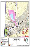 |
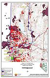
Figure 3-2Fire History and Critical Features Potentially at Risk, Washoe County, Nevada |
 |