![]()
![]()
8.0 Red Rock
8.1 Risk and Hazard Assessment
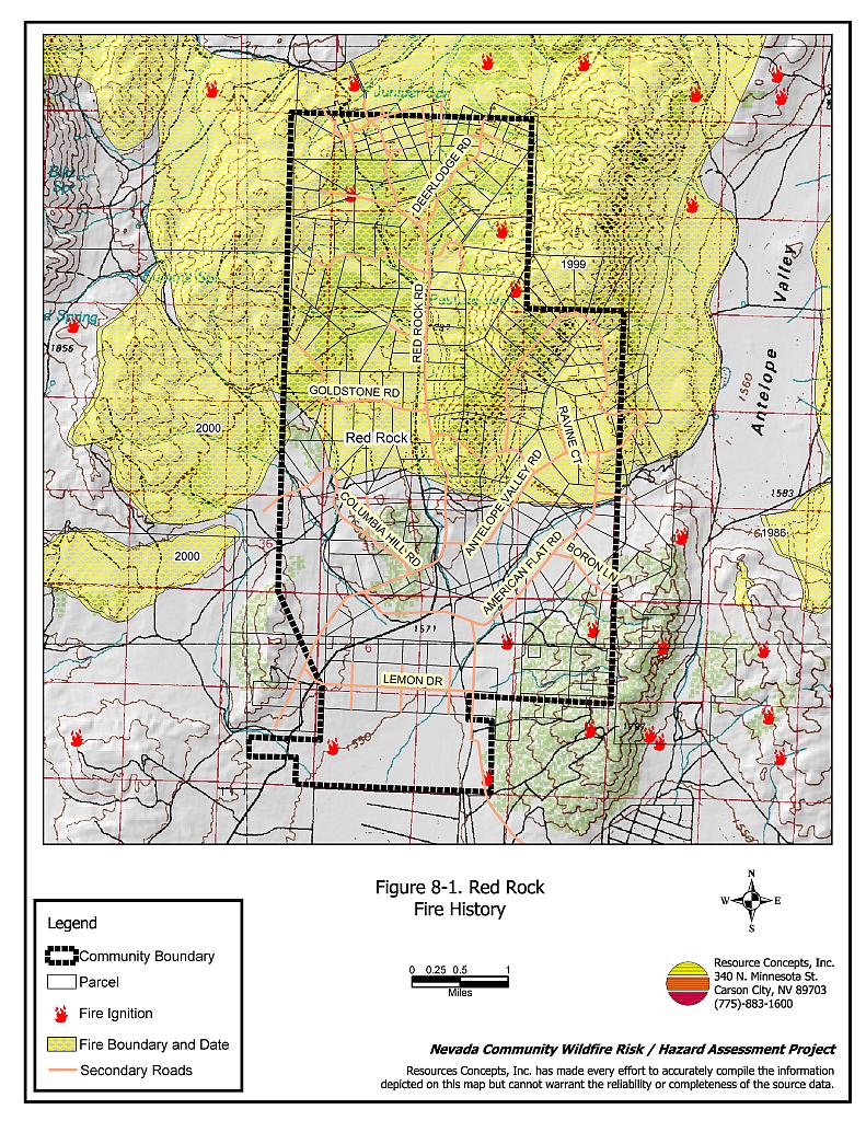
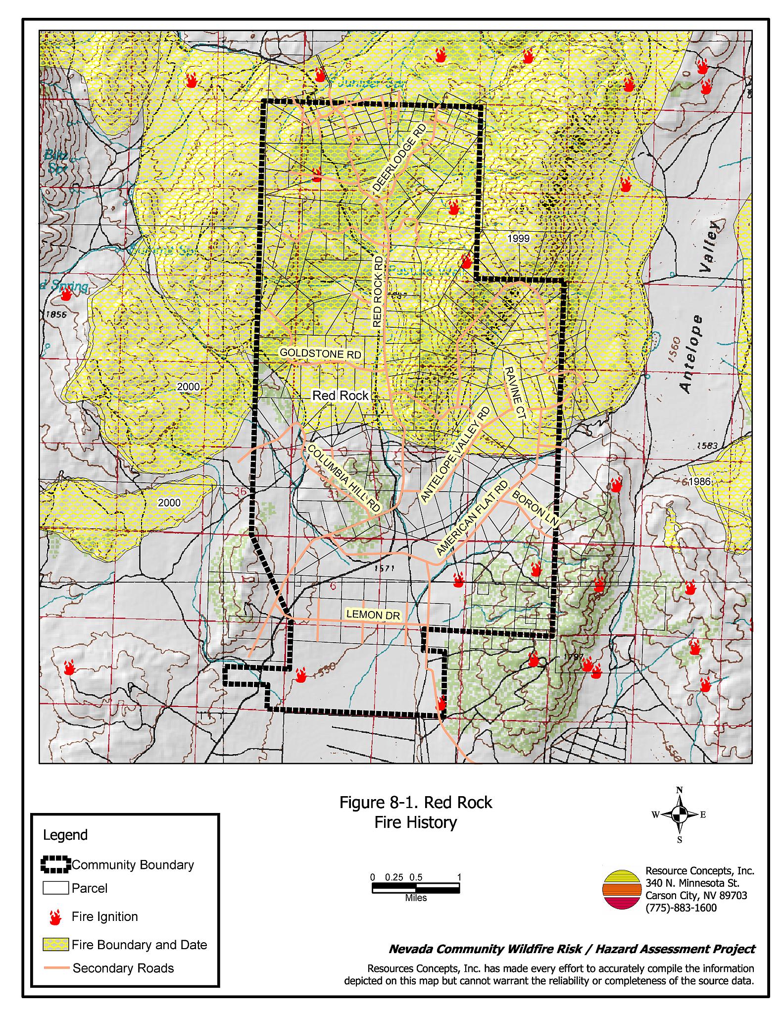
The Red Rock Community is located near the western boundary of Washoe County, west of Antelope Valley and north of US Highway 395. The community is situated at the base of the east slope of the Peterson Mountains. The community boundary is shown in Figure 8-1. The community hazard assessment resulted in classifying Red Rock in the High Hazard Category (63 points). A summary of factors that contributed to the hazard rating is included in Table 8-3. Primary factors that determined the hazard rating in Red Rock included the potential fire behavior related to topography and vegetative fuels, limited water sources within the community for fire suppression, limited fire suppression resources, and inadequate address signage throughout the community.
8.1.1 Community Design
The wildland-urban interface area in Red Rock is characterized as an intermix condition. There is no clear line of demarcation between wildland fuels and the residential structures in the community. Most of the residences are located on lots less than one acre in size (see Figure 8-1).
- Access: Red Rock Road is the primary transportation route providing access to the community. The road is greater than 24 feet wide, which provides adequate space for two-way vehicular travel and for fire suppression equipment to maneuver.
- Signage: All street signs are adequately signed and easily visible, however almost twenty percent of residential addresses are not easily visible from the road. Clear and visible street signs and residential addresses are important in locating homes during low visibility conditions that occur during a wildfire.
- Utilities: All utilities are above ground. Power lines have been properly maintained minimizing the possibility that arcing may start fires in nearby vegetation. In some cases the recommended ten feet of vegetation clearance does not exist around propane tanks.
8.1.2 Construction Materials
Most of the homes in the interface are built with non-combustible or ignition resistant siding such as medium density fiberboard, stucco, or brick. All of the homes had roofs of non-combustible material such as tile, metal, or composition. Approximately eleven percent of the homes observed had unenclosed balconies, porches, decks, or other architectural features that can create drafty areas where sparks and embers can be trapped, smolder, ignite, and rapidly spread fire to the house.
8.1.3 Defensible Space
Approximately 93 percent of the homes surveyed in the Red Rock Community have landscaping that meets defensible space guidelines to protect the home from damage or loss during a wildfire.
8.1.4 Suppression Capabilities
Wildfire Protection Resources
There is no fire department or other fire suppression resources located in the Red Rock community. The two closest fire stations that provide fire protection for Red Rock are the Red Rock Volunteer Fire Department (located in Rancho Haven) and the Silver Knolls Volunteer Fire Department, both supervised by the Reno/Truckee Meadows Fire Department. The closest resources available to respond to a reported wildland fire near Red Rock are summarized in Table 8-1.
| Type of Resource | Amount of Equipment | Cooperating Partner (Resource Location) |
|---|---|---|
| Engine Type 1 Engine Type 3 Water Tender |
1 2 1 |
Red Rock Volunteer Fire Department Truckee Meadows Station 40 - Rancho Haven) |
| Engine Type 1 Engine Type 3 |
1 1 |
Silver Knolls Volunteer Department (Truckee Meadows Station 21 - Silver Knolls) |
| Source: Roy Slate and Marty Scheuerman Reno FD 9/21/04 | ||
Reno/Truckee Meadows responds with resources from the closest available career staffed station according to their standard wildland fire dispatch. Additional resources are available upon request from local, state, and federal agencies through mutual aid agreements as described in Section 4.1.1.
Detection and Communication
Fires are reported in Washoe County through the 911 system, which connects the call with the Washoe County 911 Center. Washoe County 911 notifies the Sierra Front Interagency Dispatch Center of wildland fires. The Sierra Front Interagency Dispatch Center notifies the Volunteer Fire Departments, the Nevada Division of Forestry, the Bureau of Land Management, and the US Forest Service of fires through the use of pagers and radios.
Communication frequencies are currently compatible between agencies. When the federal agencies go to narrow band digital radios, the volunteers will no longer be able to communicate with the Bureau of Land Management and US Forest Service.
Water Sources and Infrastructure
Water available for fire suppression is very limited in the Red Rock area. There are no fire hydrants or water storage tanks. Water sources consist of private wells and ponds located in the canyon between Red Rock and Rancho Haven. The round trip time to refill fire apparatus is more than 45 minutes.
Community Preparedness
Red Rock is included in the Washoe County All-Risk Emergency Plan.
8.1.5 Factors Affecting Fire Behavior
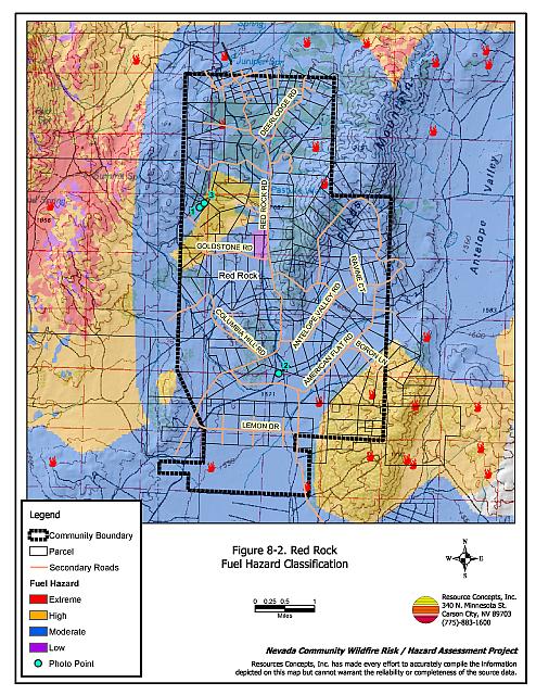
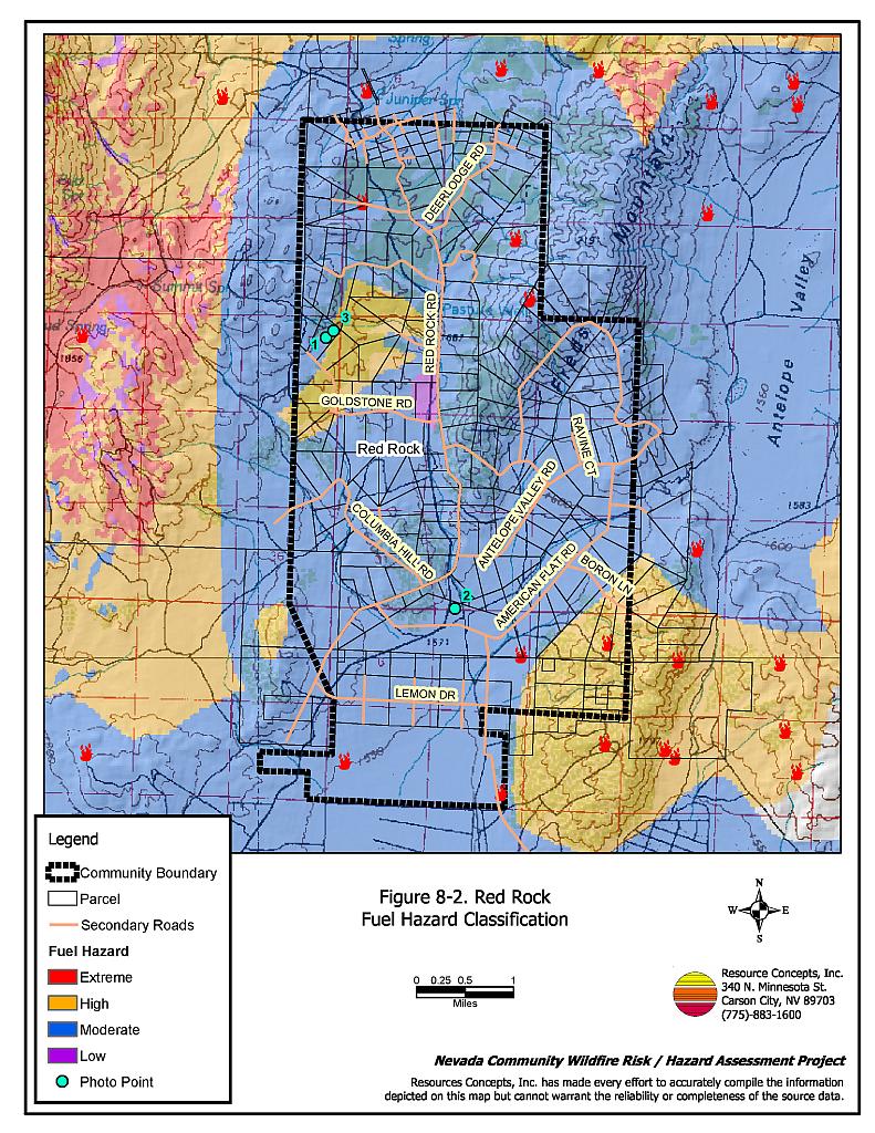
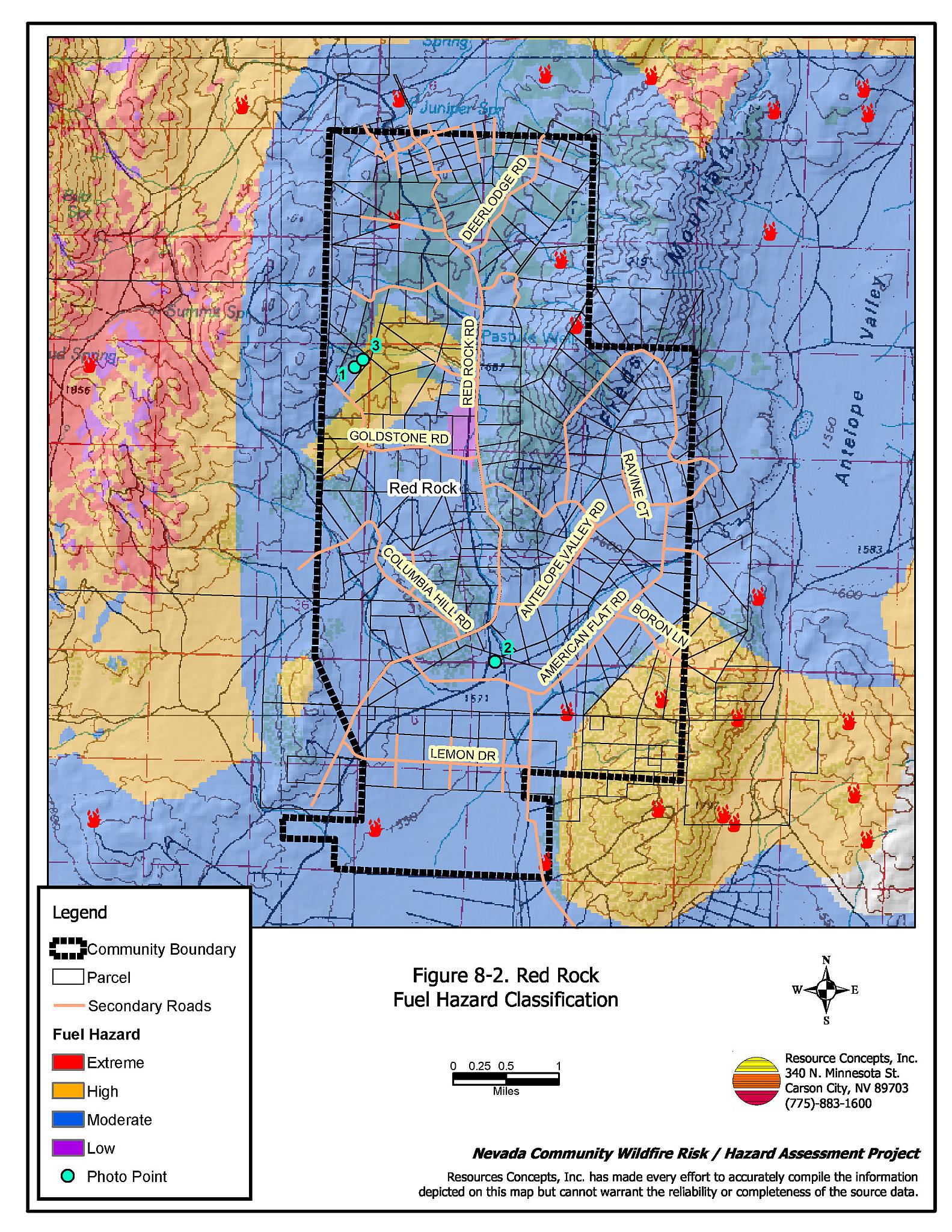
Vegetative as well as dead and down fuels combined with topographical features contribute to the potential fire hazard around wildland-urban interface communities. Fuel hazard maps for the Red Rock wildland-urban interface and representative fuel hazard photo points are provided in Figures 8-2 and 8-3.
The Red Rock community is situated in the bottom of the valley along the west and south sides of Fred’s Mountain. Slopes in the community range from almost flat to twenty percent with various aspects. The elevation is approximately 4,900 feet. The prevailing wind direction is from the south and southwest. High speed, erratic winds are common, especially during summer afternoons. Several canyons with unburned vegetation adjacent to homes could contribute to unpredictable fire behavior. Many fires and lightning-caused ignitions have affected the Red Rock community, especially in 1999 and 2000.
The vegetation in the south and west portions of the community is dominated by Wyoming big sagebrush, rabbitbrush, bottlebrush squirreltail, Indian ricegrass, needlegrass, and cheatgrass. Occasional burned and unburned juniper trees are present. Fuel loads were estimated to range between two and six tons per acre and the fuel hazard was considered moderate. Utah juniper is the dominant species in the unburned areas on the west side of the community with an understory of big sagebrush, bottlebrush squirreltail, and cheatgrass. The fuel loads in these areas were considerably higher than other areas of the community, estimated at four to eight tons per acre and considered a high fuel hazard.
Fuels in the recently burned areas around the community are composed of crested wheatgrass, cheatgrass, rabbitbrush, and Mormon tea. Fuel loads were estimated between one and two tons per acre and were considered a low to moderate fuel hazard.
8.1.6 Fire Behavior Worst-Case Scenario
The worst-case scenario would begin as an ignition in a previously burned area west of the community with abundant fine fuels, primarily cheatgrass. Strong southwest winds, greater than twenty miles per hour, would push the fire into areas of dense, unburned brush and juniper and would threaten several homes. There is no fire department or water supply in the community. The volunteer stations in the neighboring communities may have a limited initial response during normal work hours. The fire could quickly escape their initial attack capabilities before the career resources could arrive.
8.1.7 Ignition Risk Assessment
Red Rock has a high ignition risk rating. There is an extensive history of wildfire and fire ignitions within and surrounding the community. There is a tendency for heavy lightning in the area during the summer, and moderate to high vehicular traffic.
8.2 Risk and Hazard Reduction Recommendations
The responsibility to keep a community fire safe falls not only on the local fire protection district but also on the residents of the community, businesses, and local governments. The recommendations for the Red Rock area focus on fuel reduction and maintenance and improving water storage for fire suppression.
8.2.1 Defensible Space Treatments
Defensible space treatments are an essential first line of defense for residential structures. The goal of the treatments is to significantly reduce or remove flammable vegetation within a prescribed distance from structures. (Refer to Appendix E for the recommended defensible space area). Defensible space reduces the fire intensity and improves firefighter and homeowner chances for successfully defending a structure against oncoming wildfire.
Property Owner Recommendations
- Remove, reduce, and replace vegetation to create defensible space around homes according to the guidelines in Appendix E. This area should be kept:
- Lean: There are only small amount of flammable vegetation.
- Clean: There is no accumulation of dead vegetation or other flammable debris.
- Green: Existing plants are healthy and green during the fire season.
- Store firewood a minimum distance of thirty feet from structures.
- Clear all dead plant material and combustible materials a minimum of five feet from the exterior of all structures.
- Mow or remove brush growing against fences in the community. The minimum distance for clearance should be ten feet in grass and 25 feet in brush.
- Enclose areas under wood decks and porches when possible or maintain these areas to be free of weeds and other flammable debris. Box in eves and cover ventilation openings with very fine metal wire mesh to prevent embers from entering the attic and crawl spaces.
- Clear all vegetation and combustible materials around propane tanks for a minimum of ten feet.
- Clear weeds and brush to a width of ten feet along both sides of the driveways.
- Maintain a minimum clearance of thirty feet from the crown of trees that remain within the defensible space zone. Keep this area free of smaller trees, shrubs, and other ladder fuels.
- Trim and remove tree branches a minimum of four feet from the ground to reduce ladder fuels on all deciduous and coniferous trees within the defensible space zone. Prune all dead and diseased branches.
- Prune all tree branches to a minimum distance of fifteen feet from buildings, paying special attention around chimneys.
- Mow grass within the defensible space zone to maintain a maximum height of four inches.
- Thin sagebrush and other shrubs to a spacing between shrubs that is equal to twice the shrub height.
- Immediately dispose of cleared vegetation when implementing defensible space treatments. This material dries quickly and poses a fire hazard if left on site.
- Where possible, irrigate all trees and large shrubs that remain in close proximity to structures to increase their fire resiliency. This is especially important during drought conditions.
- Install spark arrestors on chimneys.
- Treat areas to control the invasion of knapweed. Refer to Appendix E for more information about treating this noxious weed.
- Maintain the defensible space as needed.
Reno Fire Department
- Conduct courtesy inspections of home defensible space measures.
8.2.2 Fuels Reduction Treatments
Fuel reduction treatments are applied on a larger scale than defensible space treatments. Permanently changing the fuel characteristics over large blocks of land to one of a lower volume and altered distribution reduces the risk of a catastrophic wildfire in the treated area. Reducing vegetation along roadways and driveways could reduce the likelihood of blocking access and escape routes, help contain the fire perimeter, and improve firefighter access and safety for protecting homes.
Utility Company Recommendation
- Reduce and remove vegetation to maintain clearance around power lines. Clear vegetation within fifteen feet of utility poles near the community. Remove all trees from beneath power lines.
Reno Fire Department Recommendation
- Develop and promote a program for cleaning weeds and debris from around structures and fences in the community and for biomass disposal. Continue to enforce the permit process for open burning.
8.2.3 Fire Suppression Resources and Training
Reno Fire Department Recommendations
- Meet annually with the Bureau of Land Management and the Nevada Division of forestry to review pre-attack plans and to coordinate firefighting resources and response procedures including testing radio compatibility and coverage. Upgrade radios to new narrowband/digital technologies as needed to maintain communications with the federal agencies.
- Install at least one 15,000 gallon water storage tank for fire suppression in the Red Rock area.
8.2.4 Community Coordination
Property Owner Recommendations
- Form a local chapter of the Nevada Fire Safe Council. The Nevada Fire Safe Council facilitates solutions to reduce the loss of lives and property from wildfire in Nevada’s communities. Through the establishment of a local Chapter, local communities will become part of a large network for sharing information including notification of programs and funding opportunities for fire mitigation projects such as those listed in this report. The Nevada Fire Safe Council will accept and manage grants and contracts on the Chapter’s behalf through its non-profit status. The Nevada Fire Safe Council will provide assistance and support to communities to complete fire safe plans, set priorities, educate and train community members, and promote success stories of its members. To form a local Chapter or for more information contact the:
Nevada Fire Safe Council
1187 Charles Drive
Reno, Nevada 89509
www.nvfsc.org - Ensure that residential addresses are visible from the road. Address characters should be at least four inches high, reflective, and composed of non-flammable material. Improving visibility of addresses will make it easier for those unfamiliar with the area to navigate under smoky conditions caused by a wildland fire.
Washoe County Recommendations
- Continue to require all future development in the County to meet the National Fire Codes with regard to community design, building construction and spacing, road construction and design, water supply, and emergency access. Refer to Appendix F for an example of fire safe recommendations for planning new developments.
- Facilitate coordinated and collaborative efforts at the County and State levels for consistency in fire safe community planning and enforcement of fire safe ordinances in a unified manner.
8.2.5 Public Education
A public education program that explains fire safe measures in clear and emphatic terms will have an impact on residents of the wildland-urban interface. Informed community members will be more inclined to make efforts to effectively reduce wildfire hazards around their homes and neighborhoods.
Reno Fire Department Recommendation
- Distribute copies of the publication “Living with Fire” to all property owners. This publication is free of charge. Copies can be requested from the University of Nevada Cooperative Extension.
8.3 Summary of Recommendations
| Involved Party | Recommended Treatment | Recommendation Description |
|---|---|---|
| Property Owners |
Defensible Space Treatments | Remove, reduce, and replace vegetation around homes according to the defensible space guidelines in Appendix E. |
| Community Coordination | Form a local chapter of the Nevada Fire Safe Council. Ensure that residential addresses are visible from the road. |
|
| Utility Company | Fuels Reduction | Remove trees and thin shrubs beneath power lines and utility poles. Maintain fifteen feet of clearance around utility poles. |
| Washoe County | Community Coordination | Continue to require that all future development in the County to meet the National Fire Codes in regards to construction materials, road construction and design, water supply, and other fire department needs. Facilitate coordinated and collaborative efforts at the County and State levels for consistency in fire safe community planning and enforcement of fire safe ordinances in a unified manner. |
| Reno Fire Department | Defensible Space Treatments | Conduct courtesy inspections of defensible space condition and defensible space treatments on private property. |
| Fuels Reduction | Develop and promote regular brush clearance and biomass disposal, and continue to enforce the open burn permit programs. | |
| Resources and Training | Meet annually with BLM and NDF to discuss and update pre-attack plans for the community. Install at least one 15,000 gal. water storage tank for firefighting purposes in the Red Rock area. |
|
| Public Education | Distribute copies of the publication “Living with Fire” to all property owners. |
Table 8-3Red Rock Wildfire Hazard Rating Summary |
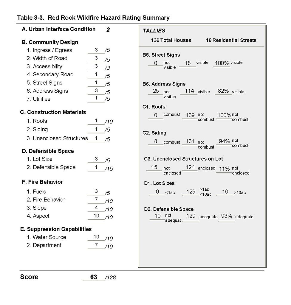 |
Figure 8-1Red Rock Fire History |
 |
Figure 8-2Red Rock Fuel Hazard Classification |
 |
Figure 8-3. Red Rock Fuel Hazard Photo Points
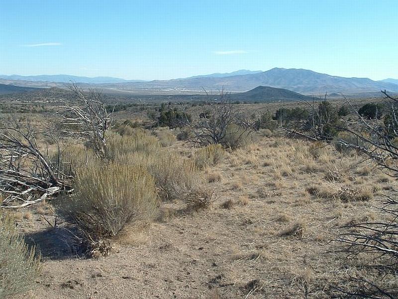
Photo Point 1. 4405477N, 0251036E, 163°SE. The fuel load in the Wyoming big sagebrush, rabbitbrush, and perennial grass areas around Red Rock was estimated at two to six tons per acre. The vertical continuity of the fuel contributes to the moderate fuel hazard.
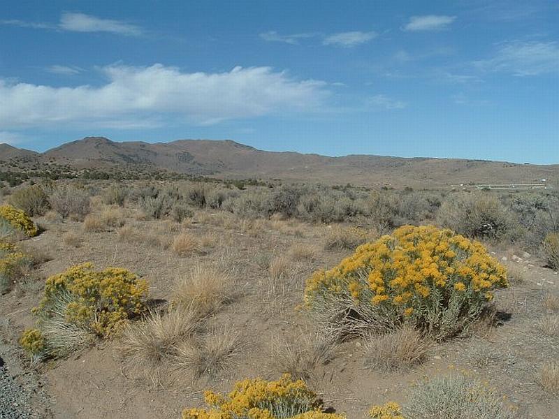
Photo Point 2. 4401000N, 0253173E, 42°NE. Cheatgrass, crested wheatgrass, rabbitbrush, and Mormon tea constitute a low to moderate fuel hazard in the recently burned areas around and within the Red Rock community.
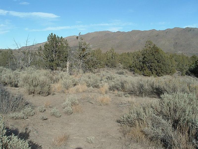
Photo Point 3. 4405595N, 0251164E, 76°NE. Vegetative fuels on the west side of the community include Utah juniper, sagebrush, and perennial grass. These area were considered a high fuel hazard with the fuel loads estimated to range between four and eight tons per acre.