![]()
![]()
13.0 Galena
13.1 Risk and Hazard Assessment
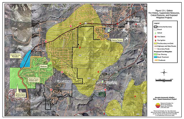
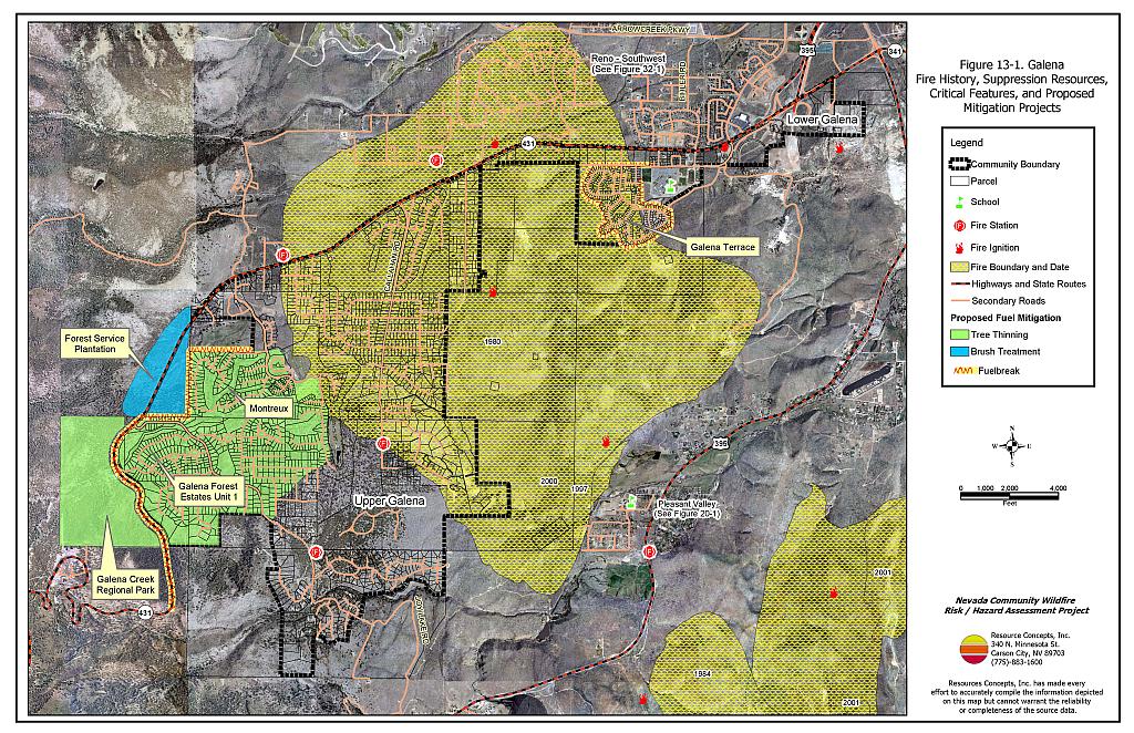
The Galena community is located in southwest Washoe County, east of the Mount Rose Corridor community and west of US Highway 395. The community is situated on the foothills of the east slope of the Carson Range. The community boundary is shown in Figure 13-1. The community hazard assessment resulted in classifying Galena in the Moderate Hazard Category (50 points). A summary of factors that contributed to the hazard rating is included in Table 13-3. Primary factors that determined the hazard rating for the Galena community included the potential for hazardous fire behavior, hazardous fuel conditions, and limited access in some areas of the community.
13.1.1 Community Design
The wildland-urban interface area in the Galena community is characterized as an intermix condition. There is no clear line of demarcation between wildland fuels and the residential structures in the community. Most of the residences are located on lots less than one acre in size.
- Access: State Route 431 (Mount Rose Highway) is the primary transportation route for the community. The highway is greater than 24 feet wide, which provides adequate space for two-way vehicular travel and for fire suppression equipment to maneuver. There are several developments in the area with locked gates and are only provided access by one road which, if blocked, could present an evacuation problem in these areas of the community. These developments also have many cul-de-sacs and long steep driveways.
- Signage: Most street signs and residence addresses in the Galena community are easily visible. Clear and visible street signs and residential addresses are important in locating homes during low visibility conditions that occur during a wildfire.
- Utilities: Utilities are both above and below ground. Power lines have not been properly maintained to minimize the possibility that arcing may start fires in nearby vegetation. In some cases the recommended ten feet of vegetation clearance does not exist around propane tanks.
13.1.2 Construction Materials
Almost all of the homes in the interface are built with non-combustible or ignition resistant siding such as medium density fiberboard, stucco, or brick. A great majority of the homes had roofs of non-combustible material such as tile, metal, or composition. Approximately nineteen percent of the homes observed had unenclosed balconies, porches, decks, or other architectural features that can create drafty areas where sparks and embers can be trapped, smolder, ignite, and rapidly spread fire to the house.
13.1.3 Defensible Space
Approximately 82 percent of the homes surveyed in Galena have landscaping that meets defensible space guidelines to protect the home from damage or loss during a wildfire.
13.1.4 Suppression Capabilities
Wildfire Protection Resources
The Nevada Division of Forestry Sierra Forest Fire Protection District has one career and two volunteer fire stations within the Galena Community. NDF Station 8 is staffed by four career personnel daily with three additional seasonal firefighters during fire season. The Galena Volunteer Fire Department has two stations and reported having twenty volunteers at the time that interviews were conducted for this report. Wildfire resources available to respond to a reported wildland fire in the Galena community are shown in Table 13-1.
| Type of Resource | Amount of Equipment | Cooperating Partner (Resource Location) |
|---|---|---|
| Engine Type 3 Water Tender Type 1 |
2 1 |
Nevada Division of Forestry (Station 8 - Galena) |
| Engine Type 3 Engine Type 2 Engine Type 1 |
2 1 1 |
Galena Volunteer Fire Department (NDF Stations 81 and 82 - Galena) |
| Source: Pete Cannizzaro, Chief Galena VFD; Joe Reinhardt, BC, Nevada Division of Forestry; Marty Scheuerman DC, Reno Fire Department; Roy Slate Volunteer Coordinator Reno Fire Department. | ||
Reno Fire Department responds with resources from the closest available career staffed station according to their standard wildland fire dispatch. Additional resources are available upon request from local, state, and federal agencies through mutual aid agreements as described in Section 4.1.1.
Water Sources and Infrastructure
Water available for fire suppression in the Galena community includes fire hydrants with minimum flow capacities of 1,000 gpm and within 1,000 feet of structures. There are several water storage tanks for the water system, which operates by gravity and electric pumps with emergency back-up generators. Some of the older areas at the end of Callaghan Ranch Road do not have hydrants.
Detection and Communication
Fires are reported in the Galena area by calling 911, which connects the caller with the Washoe County 911 Center. Washoe County 911 notifies Sierra Front Interagency Dispatch Center (SFIDC) of wildland fires. SFDIDC notifies Galena V.F.D., Nevada Division of Forestry, Bureau of Land Management, and US Forest Service resources of fires through the use of pagers and radios. The Galena VFD radios were compatible with Nevada Division of Forestry, Bureau of Land Management, and US Forest Service at the time of inquiry and the fire department had access to State Mutual Aid frequencies. Galena VFD does not have the Reno Fire Department 800 meg radios in all their engines. When the federal agencies go to narrow band digital radios, the volunteers will no longer be able to communicate with the Bureau of Land Management and US Forest Service.
Fire Protection Personnel Qualifications
All volunteer firefighters are trained to the State Fire Marshal’s Firefighter I and II standards. Wildland firefighting training is provided by Nevada Division of Forestry and meets the NWCG 310-1 standards.
Work Load
The Galena VFD responded to 400 calls in 2003 including 125 wildland/brush fire calls.
Financial Support
The financial support for the Galena Volunteer Fire Department is provided through a pay-per-call program in which the Nevada Division Forestry bills for the emergency services as they are provided as part of the Sierra Fire Protection District. NRS 473 fire districts are funded for day-to-day operations from property taxes raised within the fire district for equipment, capital improvement projects, and maintenance. For fires within an NDF Fire Protection District, the state bears the financial responsibility for all costs resulting from actions taken by NDF in suppressing fires and in minimizing damages to exposed life, property, and natural resources.
Community Preparedness
Washoe County maintains an Emergency Plan for Hazardous Materials and an All-Risk Disaster Plan through the Washoe County Local Emergency Planning Committee. The Galena VFD does pre-attack planning for fires with Nevada Division of Forestry career firefighters as part of their in-house annual fire training. The Galena Forest Estates Unit One has formed a local chapter of the Nevada Fire Safe Council.
13.1.5 Factors Affecting Fire Behavior
The Galena community is situated on the slopes and foothills at the base of the east slope of the Carson Range. Slopes in the community generally range between four and twenty percent with steeper slopes, greater than thirty percent, just west and south of the community. Elevations range from 5,400 and 6,200 feet. The prevailing wind direction is from the west and southwest. Downslope and cross slope winds are common in the afternoons of summer months. Saddles, chimneys, and steep mountain slopes are topographic features that funnel winds and could contribute to extreme fire behavior.
The fuels in upper Galena consist of a combination of sagebrush/bitterbrush and Jeffrey pine/sagebrush/bitterbrush vegetation types. In the sagebrush/bitterbrush fuel type, dominant species include mountain big sagebrush, rabbitbrush, and bitterbrush with cheatgrass and perennial grass ground fuels. In these areas the fuel loads were estimated to range between two and four tons per acre, and were considered a high fuel hazard.
Upslope, Jeffrey pine, mountain mahogany, greenleaf manzanita, tobacco brush, bitterbrush, mountain big sagebrush, and rabbitbrush are the main fuel components. Ground fuels include cheatgrass, perennial grasses, squaw carpet, dead and down woody debris, pine needles, and pinecones. The shrub layer, ranging between three and four feet in height, can act as ladder fuels and carry fire into the tree canopy, causing an extremely dangerous crown fire. The fuel load for these conditions was estimated to range between six and eighteen tons per acre and was considered a high fuel hazard.
In areas further upslope, including the Galena State Park, the mixed coniferous forest includes Jeffrey pine, white fir, and incense cedar. In these areas, there is a larger degree of dead and down woody fuels and small trees, resulting in an extreme fuel hazard classification.
13.1.6 Fire Behavior Worst-Case Scenario
The worst-case scenario for Galena would be a dry lightning storm southwest to west of the community in late afternoon on a summer day. Strong downslope winds, greater than twenty miles per hour, would push fires into Galena Park - Galena Forest Estates and St. James Village. Fires could easily develop into a crown fire, making direct fire attack impossible. Evacuation of residents would be first priority. All the locked emergency access gates will slow the evacuation process and increase the potential for loss of human life. Without thinning timber and opening up canopies, direct fire attack will be impossible until fires reach brush fields to the north and east of the area at the lower elevation.
13.1.7 Ignition Risk Assessment
There is a high fire ignition risk in Galena due to summer afternoon thunderstorms and high public use of the area west of the community. The area has a history of multiple ignitions and large fires.
13.1.8 Existing Mitigation Projects
Various subdivisions in the Galena community have completed previously recommended or required fuel reduction treatments to comply with development conditions of approval including:
1977-1982 Galena Forest Estates Phase 1: The developer was required to thin the entire subdivision. Some lots were sold prior to thinning and did not receive treatment. Thinning was completed by NDF Conservation Camp Crews to remove ladder fuels and smaller trees.
1988 Whispering Pines: A brush hog was used to remove understory shrubs. Trees were thinned on 45 acres of the 47-acre subdivision.
1990 Galena Creek Regional Park - Galena: Smaller trees were thinned and ladder fuels were removed in the day-use areas and around the NDF residence.
1994 Guerra Development (Abies Court south of Galena Forest Estates): The developer was required to reduce fuels prior to sales by removing mountain mahogany and conducting some pre-commercial and commercial tree thinning.
1994-1996 St. James Village: The developer was required to thin each lot and remove 50 percent of the brush understory on each lot prior to street paving. Brush was treated with a brush hog and masticator.
1999- Scotch Pine: The developer was required to thin fuels on the lots in the primary area of development (home sites).
2001-2002 Calamont: In 2001, the golf course fairways were clear-cut and approximately 100 acres were commercially thinned. In 2002, the remaining 150 acres of forestland were commercially thinned. Approximately 86,000 board feet of saw logs were shipped to the Sierra Pacific Industries (SPI) sawmill in Quincy, California, and 3,200 tons of biomass were chipped and shipped to the SPI wood-fired power plant in Loyalton, California.
2002-2003 St. James Village: In 2002, 100 acres were commercially thinned for fuel hazard reduction. Approximately 318,000 board feet of saw logs were sent to the SPI sawmill in Quincy, California; 4,200 tons of biomass were chipped and shipped to the SPI wood-fired power plant in Loyalton. 700 cords of firewood were shipped to a wood yard in Chilcoot, California. In 2003, a brush masticator was used to remove 50 percent of the brush on 65 acres of Homeowners’ Association green belt property.
2004 Galena Forest Estates Unit 1: In September of 2004, hand crews under contract with the Nevada Fire Safe Council completed fuel reduction treatments and defensible space treatments on three of the community parcels and several private lots within the Galena Forest Estates Unit 1 portion of the Galena community. The work was completed according to the specifications included in the Community Fire Risk, Hazard Reduction, and Project Implementation Plan (RCI 2003).
13.2 Risk and Hazard Reduction Recommendations
The responsibility to keep a community fire safe falls not only on the local fire protection district but also on the residents, businesses, and local governments. The recommendations for the Galena area focus primarily on additional efforts that could be taken by community members and public agencies to increase wildland fire safety through the reduction of hazardous fuels. Other recommendations pertain to community coordination and public education efforts that could be undertaken to enhance fire safety.
13.2.1 Defensible Space Treatments
Defensible space treatments are an essential first line of defense for residential structures. The goal of the treatments is to significantly reduce or remove flammable vegetation within a prescribed distance from structures. (Refer to Appendix E for the recommended defensible space area). Defensible space reduces the fire intensity and improves firefighter and homeowner chances for successfully defending a structure against oncoming wildfire.
Property Owner Recommendations
- Remove, reduce, and replace vegetation to create defensible space around homes according to the guidelines in Appendix E. This area should be kept:
- Lean: There are only small amounts of flammable vegetation.
- Clean: There is no accumulation of dead vegetation or other flammable debris.
- Green: Existing plants are healthy and green during the fire season.
- Store firewood a minimum distance of thirty feet from structures.
- Clear all dead plant material and combustible materials a minimum of five feet from the exterior of all structures.
- Mow or remove brush growing against wood fences in the community.
- Enclose areas under wood decks and porches when possible or maintain these areas to be free of weeds and other flammable debris. Box in eves and cover ventilation openings with very fine metal wire mesh to prevent embers from entering the attic and crawl spaces.
- Clear all vegetation and combustible materials around propane tanks for a minimum of ten feet.
- Clear weeds and brush to a width of ten feet along both sides of the driveways.
- Maintain a minimum clearance of thirty feet from the crown of trees that remain within the defensible space zone. Keep this area free of smaller trees, shrubs, and other ladder fuels.
- Trim and remove tree branches a minimum of twelve to fifteen feet from the ground or no more than one third the height of the tree to reduce ladder fuels on all deciduous and coniferous trees within the defensible space zone. Prune all dead and diseased branches.
- Prune all tree branches to a minimum distance of fifteen feet from buildings, paying special attention around chimneys.
- Thin sagebrush and other shrubs to a spacing between shrubs that is equal to twice the shrub height.
- Immediately dispose of cleared vegetation when implementing defensible space treatments. This material dries quickly and poses a fire hazard if left on site.
- Where possible, irrigate all trees and large shrubs that remain in close proximity to structures to increase their fire resiliency. This is especially important during drought conditions.
- Where cheatgrass has become dominant within the defensible space zone, areas should be mowed prior to seed maturity or treated with an application of a pre-emergent herbicide. Treatments may need to be repeated for several years to ensure that the seed bank of unwanted annual grass seeds has been depleted. Refer to Appendix E for a recommended seed mixture and planting guidelines that can be used in conjunction with cheatgrass removal.
- Replace ornamental juniper shrubs with fire resistant species.
- Replace wood shake roofs with fire resistant roofing materials.
- Maintain the defensible space as needed.
13.2.2 Fuels Reduction Treatments
Fuel reduction treatments are applied on a larger scale than defensible space treatments. Permanently changing the fuel characteristics over large blocks of land to one of a lower volume and altered distribution reduces the risk of a catastrophic wildfire in the treated area. Reducing vegetation along roadways and driveways could reduce the likelihood of blocking access and escape routes, help contain the fire perimeter, and improve firefighter access and safety for protecting homes.
Utility Company Recommendation
- Reduce and remove vegetation to maintain clearance around power lines. Clear vegetation within fifteen feet of utility poles near the community. Remove all trees from beneath power lines. Reduce and remove vegetation to maintain a minimum clearance of thirty feet from fences around power substations.
Property Owner Recommendations
- Construct and maintain a shaded fuelbreak 300 feet wide along the north and west sides of the Montreux Development.
- Construct and maintain a shaded fuelbreak 300 feet wide along the north side of Galena Forest Estates Unit One.
- Reduce ladder fuels on all private lots by removing mountain mahogany plants within thirty feet of Jeffrey pine canopies.
- Thin trees on private lots to a maximum basal area of 80 to 100 square feet per acre. (Refer to Appendix E for guidelines on tree thinning.)
- Construct and maintain a 200-foot wide fuelbreak around the Galena Terrace subdivision in Lower Galena. Thin shrub canopies to a spacing two times the height of the shrubs and seed the fuelbreak with short-stature, fire-resistant perennial species, such as recommended in Appendix E to minimize cheatgrass and noxious weed invasion.
US Forest Service Recommendation
- Remove the brush understory in the pine plantation along State Route 431.
Washoe County Parks Recommendations
- Thin trees in Galena Creek Regional Park to a basal area of 80 to 100 square feet per acre.
- Reduce ladder fuels by removing the brush and mountain mahogany from under the larger Jeffrey pines and by pruning trees to twelve to fifteen feet above ground or no more than one-third the height of the tree.
- Construct and maintain a 500-foot wide fuelbreak along State Route 431 as previously proposed in the RCI 2003 report (Priority treatments 3 and 4). Thin trees to an approximate basal area of 80 square feet per acre and thin brush and mountain mahogany canopies to a spacing of two times the height of the shrubs.
Washoe County and Nevada Department of Transportation Recommendations
- Reduce vegetation and maintain roads by mowing all vegetation to a height of no more than four inches for a distance of twenty feet from the edge of the pavement on both sides of the road. Remove biomass and dispose at an appropriate site. Reseed treated areas with fire resistant species such as recommended in Appendix E to minimize cheatgrass and noxious weed invasion.
13.2.3 Fire Suppression Resources and Training
Galena Volunteer Fire Department Recommendations
- Meet annually with the US Forest Service to review pre-attack plans and to coordinate firefighting resources and response procedures including testing radio compatibility and coverage. Upgrade radios to new narrowband/digital technologies as needed to maintain communications with the federal agencies.
13.2.4 Community Coordination
Property Owner Recommendations
- Form local chapters of the Nevada Fire Safe Council based on subdivision units with similar Codes, Covenants, and Restrictions or join with the Galena Forest Estates Unit One Fire Safe Council Chapter. The Nevada Fire Safe Council facilitates solutions to reduce the loss of lives and property from wildfire in Nevada’s communities. Through the establishment of a local Chapter, local communities will become part of a large network for sharing information including notification of programs and funding opportunities for fire mitigation projects such as those listed in this report. The Nevada Fire Safe Council will accept and manage grants and contracts on the Chapter’s behalf through its non-profit status. The Nevada Fire Safe Council will provide assistance and support to communities to complete fire safe plans, set priorities, educate and train community members, and promote success stories of its members. To form a local Chapter or for more information contact the:
Nevada Fire Safe Council
1187 Charles Drive
Reno, Nevada 89509
www.nvfsc.org - Participate in public education opportunities and become knowledgeable of emergency evacuation procedures
- Assure that address signs are visible from the road. Address characters should be at least four inches high, reflective, and composed of non-flammable material. Improving visibility of addresses will make it easier for those unfamiliar with the area to navigate under smoky conditions during a wildland fire.
Washoe County Recommendations
- Continue to require all future development in the County to meet the National Fire Codes with regard to community design, building construction and spacing, road construction and design, water supply, and emergency access. Refer to Appendix F for an example of fire safe recommendations for planning new developments.
- Enforce or develop county laws, regulations, and ordinances that support implementation and maintenance of defensible space and establish fuel reduction responsibilities for absentee homeowners and vacant lots.
- Facilitate coordinated and collaborative efforts at the County and State levels for consistency in fire safe community planning and enforcement of fire safe ordinances in a unified manner.
13.2.5 Public Education
A public education program that explains fire safe measures in clear and emphatic terms will have an impact on residents of the wildland-urban interface. Informed community members will be more inclined to make efforts to effectively reduce wildfire hazards around their homes and neighborhoods.
Galena Volunteer Fire Department and Nevada Division of Forestry Recommendation
- Distribute copies of the publication “Living with Fire” to all property owners. This publication is free of charge. Copies can be requested from the University of Nevada Cooperative Extension.
- Prepare an evacuation plan and post or otherwise distribute this plan to residents. This plan should include information regarding evacuation routes, evacuation procedures, designated fire safe zones, and procedures for sheltering in place in case evacuation becomes infeasible during a fast moving firestorm.
13.3 Summary of Recommendations
| Involved Party | Recommended Treatment | Recommendation Description |
|---|---|---|
| Property Owners |
Defensible Space | Remove, reduce, and replace vegetation around homes according to the defensible space guidelines in Appendix E. |
| Fuels Reduction | Reduce ladder fuels by removing brush and mountain mahogany from under larger Jeffrey pines. Construct a shaded fuelbreak 300 feet wide along the west side of the Montreux Development. Construct a shaded fuelbreak 300 feet wide shaded fuelbreak along the north side of Galena Forest Estates Unit One. Construct and maintain a 200-foot wide fuelbreak around the Galena Terrace subdivision in Lower Galena. |
|
| Community Coordination | Form additional local chapters of the Nevada Fire Safe Council. Improve address visibility from the road. Participate in public education opportunities and become knowledgeable of emergency evacuation procedures. |
|
| Utility Company | Fuels Reduction | Remove trees and thin shrubs beneath power lines and utility poles. Maintain fifteen feet of clearance around utility poles. |
| US Forest Service | Fuels Reduction | Remove the brush understory from pine plantation. |
| Washoe County Parks |
Fuels Reduction | Thin trees in Galena Creek Regional Park. Reduce ladder fuels by removing brush and mountain mahogany from under larger Jeffrey pines and pruning tree limbs. Construct and maintain a 500-foot wide fuelbreak along State Route 431. |
| Washoe County | Community Coordination | Continue to require all future development in the County to meet the national fire codes with regard to community design, building construction and spacing, road construction, water supply, and emergency access. Enforce or develop county laws, regulations, and ordinances for defensible space and fuels reduction that include absentee homeowners, vacant lots, and new subdivisions. Facilitate coordinated and collaborative efforts at the County and State levels for consistency in fire safe community planning and enforcement of fire safe ordinances in a unified manner. |
| Galena Volunteer Fire Department Nevada Division of Forestry |
Resources and Training | Meet annually to review pre-attack plans for the community and test radio coverage and compatibility. |
| Public Education | Coordinate the development of an emergency evacuation plan for Galena area. Distribute copies of the publication “Living with Fire” to all property owners. |
|
| Washoe County Nevada Department of Transportation |
Fuel Reduction | Reduce and remove vegetation in county and state road right-of-ways to maintain an average four-inch vegetation height. Reseed treated areas to minimize cheatgrass and noxious weed invasion. |
Table 13-3Galena Wildfire Hazard Rating Summary |
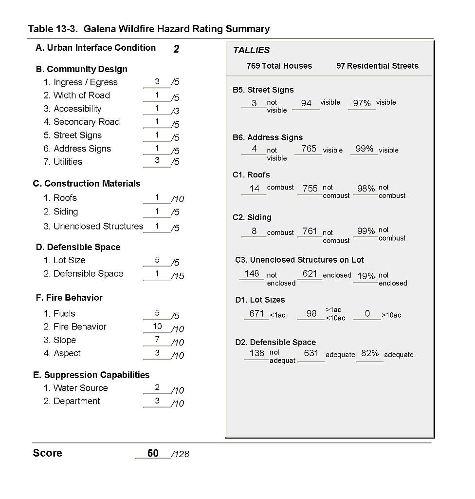 |
Figure 13-1Galena Fire History, Suppression Resources, Critical Features, and Proposed Mitigation Projects |
 |