![]()
![]()
18.0 Nixon
18.1 SWCA Hazard and Risk Assessment
SWCA Environmental Consultants completed a wildfire risk and hazard assessment for the Nixon Community in 2003 entitled “Wildfire Hazard Assessment and Mitigation Plan for the Nixon Community, Pyramid Lake Paiute Reservation.” Pertinent information for this report is summarized from the SWCA Nixon assessment. Additional observations were made during a site reconnaissance by the RCI Project Team in conjunction with the countywide assessment.
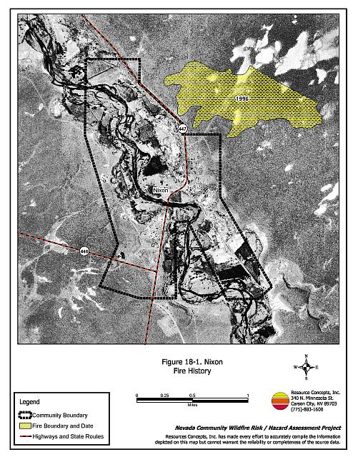
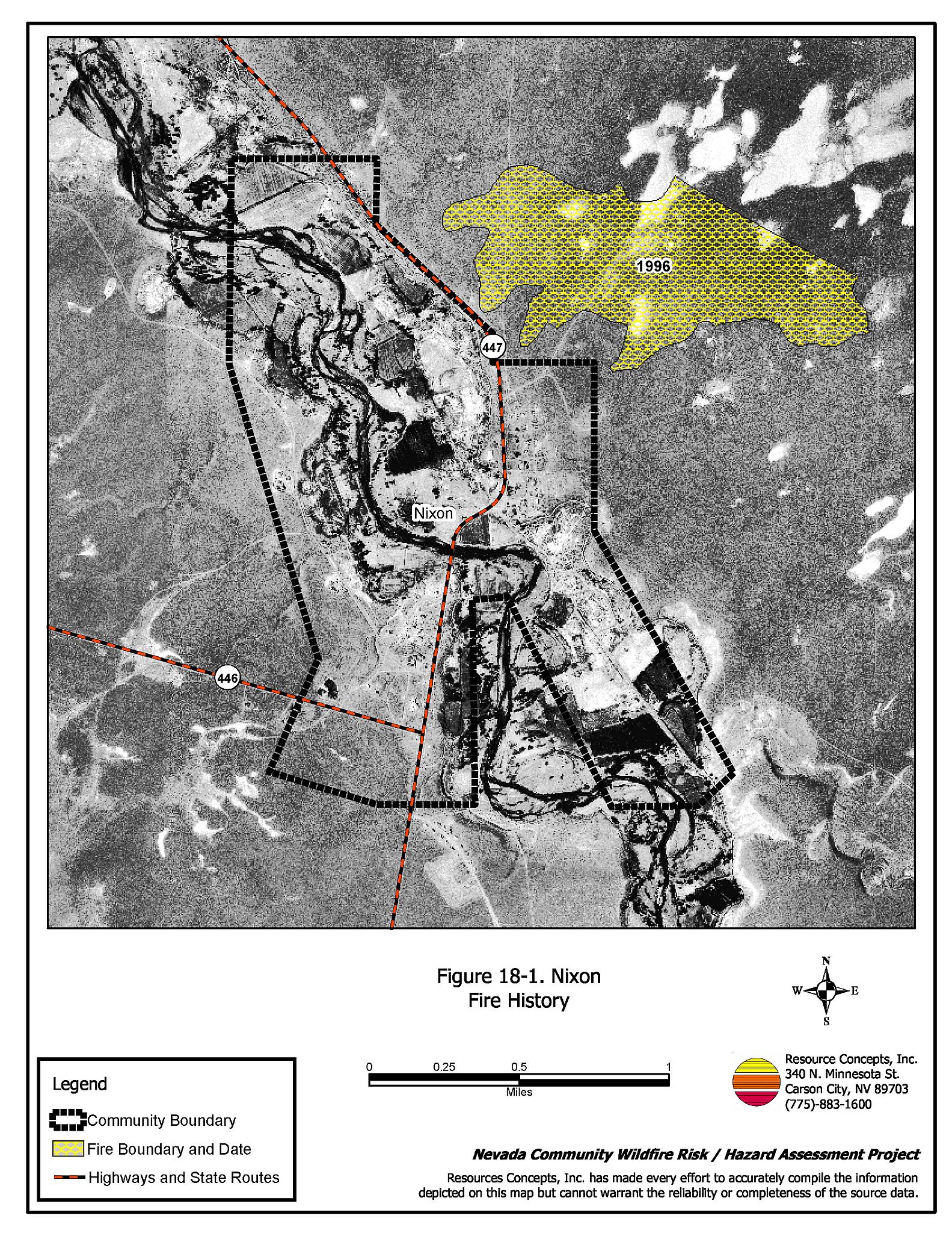
Nixon is located southeast of Pyramid Lake on the Pyramid Lake Paiute Reservation. approximately fifteen miles north of Fernley, Nevada. The community boundary is shown in Figure 18-1. There are six historic buildings and two historic structures within the community including the schoolhouse/clinic, St. Mary’s Episcopal Church, St. Joseph’s Parish, a partially collapsed storage shed, a steel water tower, a smaller schoolhouse, and the remnants of a lye processing facility. Most of the buildings are concentrated around the modern Tribal Administrative Building.
The SWCA assessment evaluated 176 structures and classified Nixon in the Moderate Hazard category. The score was attributed to patches of brush within the community, inadequate defensible space, and large amounts of combustible construction materials throughout the community.
18.1.1 Community Design
The wildland-urban interface around the Nixon community is characterized as an intermix condition. Structures are scattered throughout the wildland area with no clear line of demarcation between wildland fuels and residences in the community. Residences are concentrated along both sides of the Truckee River corridor.
- Access: The community is easily accessed from State Routes 447 and 446. Several paved roads within the community provide access to the State Routes. Several roads along the Truckee River corridor do not have adequate space for fire apparatus access. In the south part of the community the bridge that would connect Valley Road and South Hollywood has been removed resulting in only one way in and out for this portion of the community.
- Signage: SWCA reported that some of the residences and roads were lacking adequate signage to be considered a firesafe community. Residential addresses and street signs are important to aid firefighting personnel in locating homes during low visibility conditions that occur during a wildland fire.
- Utilities: No information was provided in the SWCA report regarding the condition of the utilities.
18.1.2 Construction Materials
The majority of the homes in the community are built with class C rated wood siding, which burns in less than twenty minutes. The other structures are trailer houses with metal siding, as well as three to four (five percent) residences that had upgraded to fire resistant vinyl siding. Most of the wood-structured homes have standard pitched roofs with wood joists. Attic spaces are vented under eves with unscreened louvered vents. Many of the residences have been recently updated to Class B roofing materials (asphalt shingles).
18.1.3 Defensible Space
Many of the structures assessed in Nixon have landscaping that meets the minimum defensible space requirement to help protect the home from damage or loss during a wildfire.
18.1.4 Fire Suppression Capabilities
The Nixon and Sutcliffe Volunteer Fire Departments provide fire suppression services for the Nixon community. The closest resources that are available to respond to a reported wildland fire are summarized in Table 18-1. Reno Fire Department responds with additional resources from the closest available career staffed station according to their standard wildland fire dispatch. Other local, state, and federal resources are available upon request through mutual agreements as described in Section 4.1.1.
| Type of Resource | Amount of Equipment | Cooperating Partner (Resource Location) |
|---|---|---|
| Engine Type 3 Engine Type 4 |
1 1 |
Nixon Volunteer Fire Department (Nixon) |
| Engine Type 3 Water Tender |
1 1 |
Sutcliffe Volunteer Fire Department (Truckee Meadows Station 41 - Sutcliffe) |
| Source: SWCA (2003) and Roy Slate, Reno Fire Department. | ||
Water Sources and Infrastructure
Nixon has a water storage tank with a capacity of approximately 400,000 gallons that is filled from two wells operated by electric pumps. Gravity operated fire hydrants are sparsely located throughout the community. The Truckee River and Pyramid Lake provide water drafting and helicopter dip sites near the community.
Detection and Communication
Fires are reported in Washoe County through the 911 system, which connects the call with the Washoe County 911 Center. Washoe County 911 notifies the Sierra Front Interagency Dispatch Center of wildland fires. The Sierra Front Interagency Dispatch Center notifies the Volunteer Fire Departments, the Nevada Division of Forestry, the Bureau of Land Management, and the US Forest Service of fires through the use of pagers and radios.
18.1.5 Factors Affecting Fire Behavior
The terrain around Nixon is mostly flat. The majority of the fuels surrounding the community are brush types consisting of sagebrush and rabbitbrush with cheatgrass, Indian ricegrass, needlegrass, and Sandberg bluegrass in the understory. The average shrub height ranges in height from one to three feet. The total fuel load is approximately four tons per acre, and was considered a high hazard (SWCA 2003). Irrigated lands around the community were considered a low fuel hazard. Extensive brush accumulations within the community were considered a high hazard condition for Nixon.
18.1.6 Fire Behavior Worst-Case Scenario
The RCI Project Team assessment of the worst-case wildfire scenario for the Nixon community would occur from a dry lightning strike with strong erratic winds. The fire could be pushed into the community or spot fires from firebrands could ignite within the community in farm fencing, haystacks or dense brush threatening structures. The structures at greatest risk lie east of the Truckee River.
18.1.7 Ignition Risk Assessment
The Nixon community has a high ignition risk. There is a significant history of wildfire and fire ignitions within and around the community. Summer temperatures, dry conditions, and the tendency for lightning storms and afternoon winds contribute to the ignition risk.
18.2 Risk and Hazard Reduction Recommendations
Recommendations from the SWCA 2003 assessment and from the RCI Project Team reconnaissance are summarized below.
18.2.1 Defensible Space
Vegetation density, type of fuel, and slope gradient around a home affect the potential fire exposure levels to the home. The first goal of defensible space is to reduce the risk of property loss from wildfire by eliminating flammable vegetation near the home, thereby lowering the potential to burn. The second goal of defensible space is to provide firefighters a safer working area from which to defend the home or outbuildings during a wildland fire.
Property Owner and Resident Recommendations
- Remove, reduce, and replace vegetation to create defensible space around homes according to the guidelines in Appendix E. This area should be kept:
- Lean: There are only small amount of flammable vegetation.
- Clean: There is no accumulation of dead vegetation or other flammable debris.
- Green: Existing plants are healthy and green during the fire season.
- Store firewood a minimum distance of thirty feet from structures.
- Clear all dead plant material and combustible materials a minimum of five feet from the exterior of all structures.
- Mow or remove brush growing against fences in the community. The minimum distance for clearance should be ten feet in grass and 25 feet in brush.
- Enclose areas under wood decks and porches when possible or maintain these areas to be free of weeds and other flammable debris. Box in eves and cover ventilation openings with very fine metal wire mesh to prevent embers from entering the attic and crawl spaces.
- Clear all vegetation and combustible materials around propane tanks for a minimum of ten feet.
- Clear weeds and brush to a width of ten feet along both sides of the driveways.
- Maintain a minimum clearance of thirty feet from the crown of trees that remain within the defensible space zone. Keep this area free of smaller trees, shrubs, and other ladder fuels.
- Trim and remove tree branches a minimum of four feet from the ground to reduce ladder fuels on all deciduous and coniferous trees within the defensible space zone. Prune all dead and diseased branches.
- Prune all tree branches to a minimum distance of fifteen feet from buildings, paying special attention around chimneys.
- Mow grass within the defensible space zone to maintain a maximum height of four inches.
- Thin sagebrush and other shrubs to a spacing between shrubs that is equal to twice the shrub height.
- Immediately dispose of cleared vegetation when implementing defensible space treatments. This material dries quickly and poses a fire hazard if left on site.
- Where possible, irrigate all trees and large shrubs that remain in close proximity to structures to increase their fire resiliency. This is especially important during drought conditions.
- Remove or board up abandoned trailers and structures to prevent sparks from entering and igniting the structure.
- Install spark arrestors on chimneys.
- Maintain the defensible space as needed.
18.2.2 Fuels Reduction Treatments
Fuel reduction treatments are applied on a larger scale than defensible space treatments. Permanently changing the fuel characteristics over large blocks of land to one of a lower volume and altered distribution reduces the risk of a catastrophic wildfire in the treated area. Reducing vegetation along roadways and driveways could reduce the likelihood of blocking access and escape routes, help contain the fire perimeter, and improve firefighter access and safety for protecting homes.
Pyramid Lake Paiute Tribe Recommendation
- Establish and promote a program for cleaning weeds and debris from around structures and fences in the community. Develop a biomass disposal program and a permit process for open burning.
Utility Company Recommendation
- Reduce and remove vegetation to maintain clearance around power lines. Clear vegetation within fifteen feet of utility poles near the community. Remove all trees from beneath power lines. Reduce and remove vegetation to maintain a minimum clearance of thirty feet from fences around power substations.
18.2.3 Fire Suppression Resources and Training
Fire suppression capabilities and resources are essential to creating a firesafe community. Emergency response personnel, local residents, and those unfamiliar with the community need adequate signage to navigate through the community under adverse conditions associated with emergencies like wildfire. Infrastructure and water sources are critical to structural and wildland fire suppression and control, especially pertaining to the occurrence of fire within the community or the wildland-urban interface.
Nixon Volunteer Fire Department
- Meet annually with the Bureau of Land Management and Reno/Truckee Meadows Fire District to review pre-attack plans and to coordinate firefighting resources and response procedures including testing radio compatibility and coverage. Upgrade radios to new narrowband/digital technologies as needed to maintain communications with the federal agencies.
- Provide all volunteer firefighters with basic wildland fire training and equipment as described in the National Wildfire Coordinating Group (NWCG) Wildland and Prescribed Fire Qualification System Guide 310-1. Provide annual wildland firefighting refresher training and fire shelter training.
18.2.4 Community Coordination and Education
Many of the most effective activities aimed at reducing the threat of wildfire for the Nixon community require that individual property owners coordinate with each other and with local fire authorities. Public education and awareness, neighbors helping neighbors, and proactive individuals setting examples for others to follow are just some of the approaches that will be necessary to meet the fire safe goals in the community.
Property Owner and Resident Recommendations
- Ensure that address signs are visible from the road. Address characters should be at least four inches high, reflective, and composed of non-flammable material. Improving visibility of addresses will make it easier for those unfamiliar with the area to navigate under smoky conditions during a wildland fire.
Pyramid Lake Paiute Tribe and Bureau of Indian Affairs Recommendation
- Replace the bridge between Valley Road and South Hollywood Road across the Truckee River.
- Coordinate with the Washoe County Assessor and the Washoe County Roads Department to ensure that all roads are named, mapped, identified with GPS coordinates, and included in the 911 database.
- Require all future development to meet the National Fire Codes with regard to community design, building construction and spacing, road construction and design, water supply, and emergency access. Refer to Appendix F for an example of fire safe recommendations for planning new developments.
- Facilitate coordinated and collaborative efforts at the County and State levels for consistency in fire safe community planning and enforcement of fire safe ordinances in a unified manner.
- Increase wildfire awareness through community newsletters, publications, meetings, and workshops. Distribute copies of the publication “Living with Fire” to all residents. This publication is free of charge and copies can be requested from the University of Nevada Cooperative Extension.
18.3 Summary of Recommendations
| Involved Party | Recommended Treatment | Recommendation Description |
|---|---|---|
| Residents and Property Owners | Defensible Space | Remove, reduce, and replace vegetation around homes according to the defensible space guidelines in Appendix E. |
| Community Coordination | Ensure that residential address signs are easily visible from the road. | |
| Utility Company | Fuels Reduction | Remove trees and thin shrubs beneath power lines and utility poles. Maintain fifteen feet of clearance around utility poles. |
| Nixon Volunteer Fire Department | Fire Suppression Resources Training | Meet with the Bureau of Land Management and the Reno/Truckee Meadows Fire Protection District annually to coordinate pre-attack plans and test radio compatibility and coverage. Provide all volunteers with wildland fire training and equipment. Require all volunteers to attend annual training wildland suppression refresher training. |
| Fuels Reduction | Establish and promote a program for cleaning weeds and debris from around structures and fences in the community. Develop a biomass disposal program and a permit process for open burning. | |
| Pyramid Lake Paiute Tribe Bureau of Indian Affairs |
Community Coordination and Education | Replace the bridge between Valley Road and South Hollywood Road across the Truckee River. Ensure that all roads are named, mapped, identified with GPS coordinates, and entered in the 911 database. Require all future development to meet the National Fire Codes regarding community design, building construction and spacing, road construction and design, water supply, and emergency access. Facilitate coordinated and collaborative efforts at the County and State levels for consistency in fire safe community planning and enforcement of fire safe ordinances in a unified manner. Increase wildfire issue awareness through community newsletters, publications, meetings, and workshops. Distribute copies of the publication “Living with Fire” to all residents. |
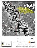
Figure 18-1Nixon Fire History |
 |