![]()
![]()
20.0 Pleasant Valley
20.1 Risk and Hazard Assessment
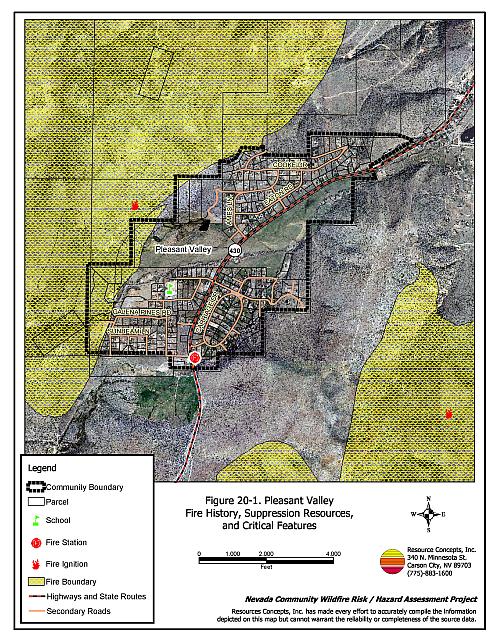
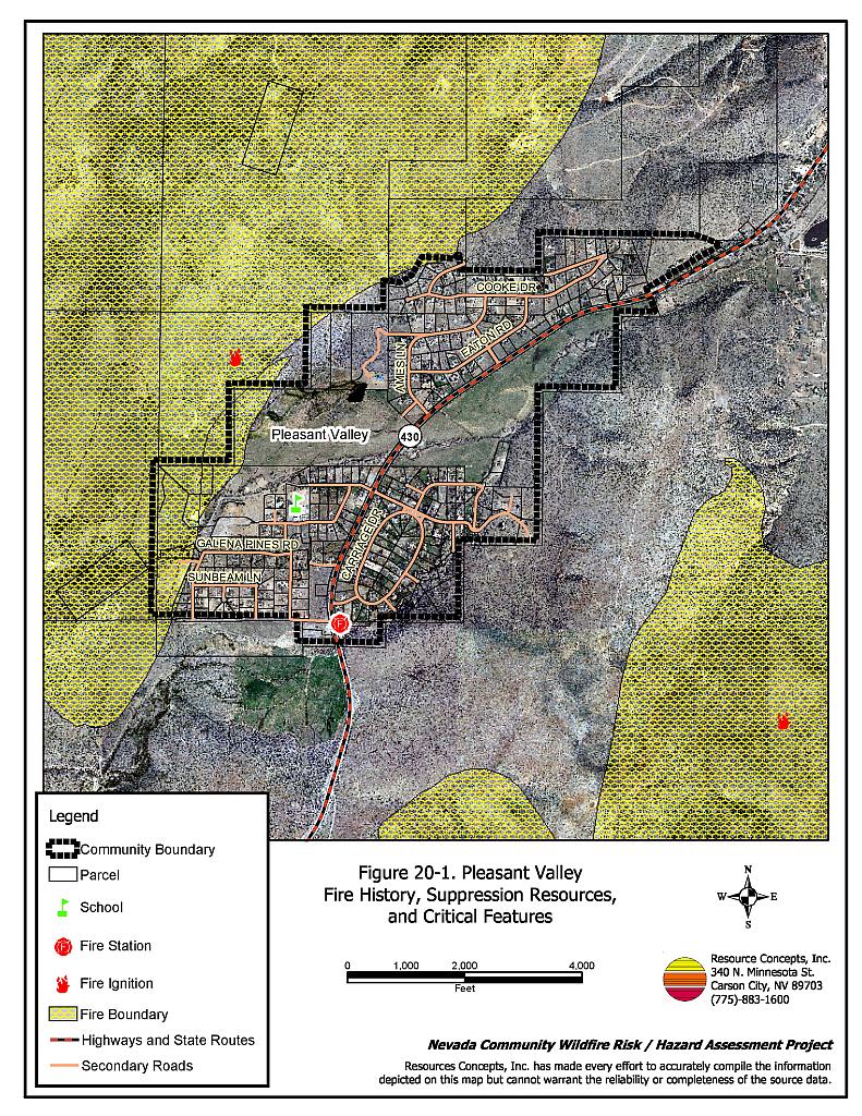
The Pleasant Valley community is located approximately four miles south of Reno between Steamboat and Washoe City. The community is situated at the base of the Carson Range and Virginia Range foothills. The community boundary is shown in Figure 20-1. The community hazard assessment resulted in classifying Pleasant Valley in the Moderate Hazard Category (41 points). A summary of factors that contributed to the hazard rating is included in Table 20-3. Primary factors that determined the hazard rating in Pleasant Valley included the potential fire behavior factors and high number of homes with flammable roofing materials.
20.1.1 Community Design
The wildland-urban interface area in Pleasant Valley is characterized as the classic interface condition. There is a clear line of demarcation between wildland fuels and the residential structures in the community. Most of the residences are located on lots less than ten acres in size.
- Access: US Highway 395 is the primary transportation route providing access to the community. The road is greater than 24 feet wide, which provides adequate space for two-way vehicular travel and for fire suppression equipment to maneuver. Some driveways are over 200 feet long and are located on steep slopes that may inhibit access for some suppression apparatus.
- Signage: Ninety-six percent of the street signs in the community are easily visible. Almost all of the residential addresses are easily visible from the road. Clear and visible street signs and residential addresses are important in locating homes during low visibility conditions that occur during a wildfire.
- Utilities:All utilities are above ground. Power lines have not been properly maintained in all areas of the community. Proper maintenance minimizes the possibility that arcing may start fires in nearby vegetation. In some cases the recommended ten feet of vegetation clearance did not exist around propane tanks.
20.1.2 Construction Materials
Most of the homes in the interface are built with non-combustible or ignition resistant siding such as medium density fiberboard, stucco, or brick. Almost all of the homes have roofs of non-combustible material such as tile, metal, or composition. Approximately fourteen percent of the homes observed have unenclosed balconies, porches, decks, or other architectural features that can create drafty areas where sparks and embers can be trapped, smolder, ignite, and rapidly spread fire to the house.
20.1.3 Defensible Space
Approximately 84 percent of the homes surveyed in Pleasant Valley have landscaping that meets defensible space guidelines to protect the home from damage or loss during a wildfire.
20.1.4 Suppression Capabilities
Wildfire Protection Resources
The Pleasant Valley Volunteer Fire Department provides fire protection for the Pleasant Valley community. Pleasant Valley is included in the Reno/Truckee Meadows Fire District. The volunteer fire department has one station and reported having twenty volunteers at the time the interviews were conducted for this report. The closest resources available to respond to a reported wildland fire are summarized in Table 20-1.
| Type of Resource | Amount of Equipment | Cooperating Partner (Resource Location) |
|---|---|---|
| Engine Type 1 Engine Type 3 Engine Type 6 |
2 2 2 |
Pleasant Valley Volunteer Fire Department (Truckee Meadows Station 43) |
| Source: John Schuler, Chief Pleasant Valley VFD; Marty Scheuerman DC, Reno Fire Department; Roy Slate Volunteer Coordinator Reno Fire Department. | ||
Water Sources and Infrastructure
Water available for fire suppression in Pleasant Valley includes fire hydrants with minimum flow capacities of 1,000 gallons per minute within 1,000 feet of structures. The water system includes several storage tanks. The water system operates on gravity and electric pumps. Structures east of Highway 395 do not have hydrants.
Detection and Communication
Fires are reported in Washoe County through the 911 system, which connects the call with the Washoe County 911 Center. Washoe County 911 notifies the Sierra Front Interagency Dispatch Center of wildland fires. The Sierra Front Interagency Dispatch Center notifies the Volunteer Fire Departments, the Nevada Division of Forestry, the Bureau of Land Management, and the US Forest Service of fires through the use of pagers and radios.
Communication frequencies are currently compatible between agencies. When the federal agencies go to narrow band digital radios, the volunteers will no longer be able to communicate with the Bureau of Land Management and US Forest Service.
Fire Protection Personnel Qualifications
All volunteer firefighters are trained to the State Fire Marshal’s Firefighter I and II standards. Wildland firefighting training is provided to meet the NWCG 310-1 standards.
Work Load
The Pleasant Valley Volunteer Fire Department responded to 165 calls in 2003 that included 25 wildland/brush fire calls.
Financial Support
Financial support for the Pleasant Valley Volunteer Fire Department is provided from the Reno/Truckee Meadows Fire District and fundraisers.
Community Preparedness
Washoe County maintains an Emergency Plan for Hazardous Materials and an All-Risk Disaster Plan through the Washoe County Local Emergency Planning Committee.
20.1.5 Factors Affecting Fire Behavior
The terrain surrounding Pleasant Valley is flat in the valley bottom with steeper south-facing slopes on the north and east sides of the valley. Many homes are located on the hillsides in narrow canyons. The prevailing wind direction is from the southwest and west. Downslope winds common during summer afternoons.
In the northwest portion of Pleasant Valley and near the Pleasant Valley fire station, the dominant vegetation consists of big sagebrush, rabbitbrush, and occasional bitterbrush with a grass layer of cheatgrass and perennial grasses. The fuel load in these areas was estimated at two to three tons per acre and was considered a moderate fuel hazard. In the southwest part of Pleasant Valley, south of the Pagni Ranch and west to the service road from Pleasant Valley to St. James Village, the same shrub composition exists, but shrub stands are denser and taller. Fuel loads were estimated at four to six tons per acre and considered a high fuel hazard.
20.1.6 Fire Behavior Worst-case Scenario
The worst-case scenario would be a dry lightning storm on a late afternoon in the summer of a year with above normal precipitation and abundant cheatgrass production. Multiple fire ignitions and strong erratic winds, greater than twenty miles per hour, would push multiple fires down slope and into structures from any direction. The heaviest fuel loadings are located on the south and east sides of the valley with a narrow strip behind structures on the northwest side of the valley. Homes with wood shake roofs and inadequate defensible space in neighborhoods without fire hydrants would be quickly threatened and at greatest risk.
20.1.7 Ignition Risk Assessment
There is a high potential for fire ignition in the Pleasant Valley area due to summer afternoon thunderstorms and high use of the area by the public. The area has a history of multiple ignitions and large fires.
20.2 Risk and Hazard Reduction Recommendations
The responsibility to keep a community fire safe falls not only on the local fire protection district but also on the residents of the community, businesses, and local governments. Providing and maintaining defensible space is the most important recommendation for the Pleasant Valley community.
20.2.1 Defensible Space Treatments
Defensible space treatments are an essential first line of defense for residential structures. The goal of the treatments is to significantly reduce or remove flammable vegetation within a prescribed distance from structures. (Refer to Appendix E for the recommended defensible space area). Defensible space reduces the fire intensity and improves firefighter and homeowner chances for successfully defending a structure against oncoming wildfire.
Property Owner Recommendations
- Remove, reduce, and replace vegetation to create defensible space around homes according to the guidelines in Appendix E. This area should be kept:
- Lean: There are only small amount of flammable vegetation.
- Clean: There is no accumulation of dead vegetation or other flammable debris.
- Green: Existing plants are healthy and green during the fire season.
- Store firewood a minimum distance of thirty feet from structures.
- Clear all dead plant material and combustible materials a minimum of five feet from the exterior of all structures.
- Mow or remove brush growing against fences in the community. The minimum distance for clearance should be ten feet in grass and 25 feet in brush.
- Enclose areas under wood decks and porches when possible or maintain these areas to be free of weeds and other flammable debris. Box in eves and cover ventilation openings with very fine metal wire mesh to prevent embers from entering the attic and crawl spaces.
- Clear all vegetation and combustible materials around propane tanks for a minimum of ten feet.
- Clear weeds and brush to a width of ten feet along both sides of the driveways.
- Maintain a minimum clearance of thirty feet from the crown of trees that remain within the defensible space zone. Keep this area free of smaller trees, shrubs, and other ladder fuels.
- Trim and remove tree branches a minimum of four feet from the ground to reduce ladder fuels on all deciduous and coniferous trees within the defensible space zone. Prune all dead and diseased branches.
- Prune all tree branches to a minimum distance of fifteen feet from buildings, paying special attention around chimneys.
- Install spark arrestors on chimneys.
- Replace wood shake roofs with fire resistant roofing materials.
- Mow grass within the defensible space zone to maintain a maximum height of four inches.
- Thin sagebrush and other shrubs to a spacing between shrubs that is equal to twice the shrub height.
- Replace ornamental juniper in landscaped areas with fire resistant species.
- Immediately dispose of cleared vegetation when implementing defensible space treatments. This material dries quickly and poses a fire hazard if left on site.
- Where possible, irrigate all trees and large shrubs that remain in close proximity to structures to increase their fire resiliency. This is especially important during drought conditions.
- Where cheatgrass has become dominant within the defensible space zone, areas should be mowed prior to seed maturity or treated with an application of a pre-emergent herbicide.[13] Treatments may need to be repeated for several years to ensure that the seed bank of unwanted annual grass seeds has been depleted. Refer to Appendix E for a recommended seed mixture and planting guidelines that can be used in conjunction with cheatgrass removal.
- Maintain the defensible space as needed.
20.2.2 Fuels Reduction Treatments
Fuel reduction treatments are applied on a larger scale than defensible space treatments. Permanently changing the fuel characteristics over large blocks of land to one of a lower volume and altered distribution reduces the risk of a catastrophic wildfire in the treated area. Reducing vegetation along roadways and driveways could reduce the likelihood of blocking access and escape routes, help contain the fire perimeter, and improve firefighter access and safety for protecting homes.
Utility Company Recommendation
- Reduce and remove vegetation to maintain clearance around power lines. Clear vegetation within fifteen feet of utility poles near the community. Remove all trees from beneath power lines. Reduce and remove vegetation to maintain a minimum clearance of thirty feet from fences around power substations.
Washoe County Roads Department and Nevada Department of Transportation Recommendation
- Reduce vegetation and maintain roads by mowing all vegetation to a height of no more than four inches for a distance of twenty feet from the edge of the pavement on both sides of the road. Remove biomass and dispose at an appropriate site. Reseed treated areas with fire resistant species such as recommended in Appendix E to minimize cheatgrass and noxious weed invasion.
20.2.3 Fire Suppression Resources and Training
Pleasant Valley Volunteer Fire Department Recommendation
- Meet annually with the Nevada Division of Forestry, Bureau of Land Management, US Forest Service, and Reno/Truckee Meadows Fire Department to review pre-attack plans and to coordinate firefighting resources and response procedures including testing radio compatibility and coverage. Upgrade radios to new narrowband/digital technologies as needed to maintain communications with the federal agencies.
20.2.4 Community Coordination
Property Owner Recommendation
- Assure that address signs are visible from the road. Address characters should be at least four inches high, reflective, and composed of non-flammable material. Improving visibility of addresses will make it easier for those unfamiliar with the area to navigate under smoky conditions during a wildland fire.
Washoe County Recommendations
- Continue to require all future development in the County to meet the National Fire Codes with regard to community design, building construction and spacing, road construction and design, water supply, and emergency access. Refer to Appendix F for an example of fire safe recommendations for planning new developments.
- Develop and enforce ordinances regarding fuel reduction and defensible space requirements for wildland-urban interface areas. Require defensible space implementation and maintenance on all developed lots and fuel reduction on all vacant lots within the interface area. Require approval by the appropriate fire agency of completed fuel reduction treatments prior to issuance of building permits for new wildland-urban interface developments.
- Facilitate coordinated and collaborative efforts at the County and State levels for consistency in fire safe community planning and enforcement of fire safe ordinances in a unified manner.
20.2.5 Public Education
A public education program that explains fire safe measures in clear and emphatic terms will have an impact on residents of the wildland-urban interface. Informed community members will be more inclined to make efforts to effectively reduce wildfire hazards around their homes and neighborhoods.
Property Owner Recommendation
- Participate in public education opportunities and become knowledgeable of emergency evacuation procedures.
Pleasant Valley Volunteer Fire Department Recommendations
- Distribute copies of the publication “Living with Fire” to all property owners. This publication is free of charge. Copies can be requested from the University of Nevada Cooperative Extension.
- Prepare an evacuation plan and post or otherwise distribute this plan to residents. This plan should include information regarding evacuation routes, evacuation procedures, designated fire safe zones, and procedures for sheltering in place in case evacuation becomes infeasible during a fast moving firestorm.
20.3 Summary of Recommendations
| Involved Party | Recommended Treatment | Recommendation Description |
|---|---|---|
| Property Owners |
Defensible Space | Remove, reduce, and replace vegetation around homes according to the defensible space guidelines in Appendix E. |
| Community Coordination | Improve address visibility from the road. Participate in public education opportunities and become knowledgeable of emergency evacuation procedures |
|
| Utility Company | Fuels Reduction | Reduce and maintain vegetation in power line corridors. Maintain fifteen feet of clearance around utility poles. Maintain thirty feet of clearance from the fence around power substations. |
| Washoe County Nevada Department of Transportation |
Fuels Reduction | Reduce and remove vegetation in county road right-of-ways to maintain an average four-inch vegetation height within twenty feet of the edge of pavement. Reseed treated areas to minimize cheatgrass and noxious weed invasion |
| Washoe County | Community Coordination | Continue to require all future development in the County to meet the National Fire Codes with regard to community design, building construction and spacing, road construction, water supply, and emergency access. Develop and/or enforce county laws, regulations, and ordinances for defensible space and fuels reduction that include absentee homeowners, vacant lots, and new subdivisions. Facilitate coordinated and collaborative efforts at the County and State levels for consistency in fire safe community planning and enforcement of fire safe ordinances in a unified manner. |
| Pleasant Valley VFD | Resources and Training | Meet annually with the Nevada Division of Forestry, the Truckee Meadows Fire Department, the Bureau of Land Management, and the US Forest Service to discuss and update pre-attack plans for the community and test radio coverage and compatibility. |
| Public Education | Develop an emergency evacuation plan for Pleasant Valley area. Distribute copies of the publication “Living with Fire” to all property owners. |
Table 20-3Pleasant Valley Wildfire Hazard Rating Summary |
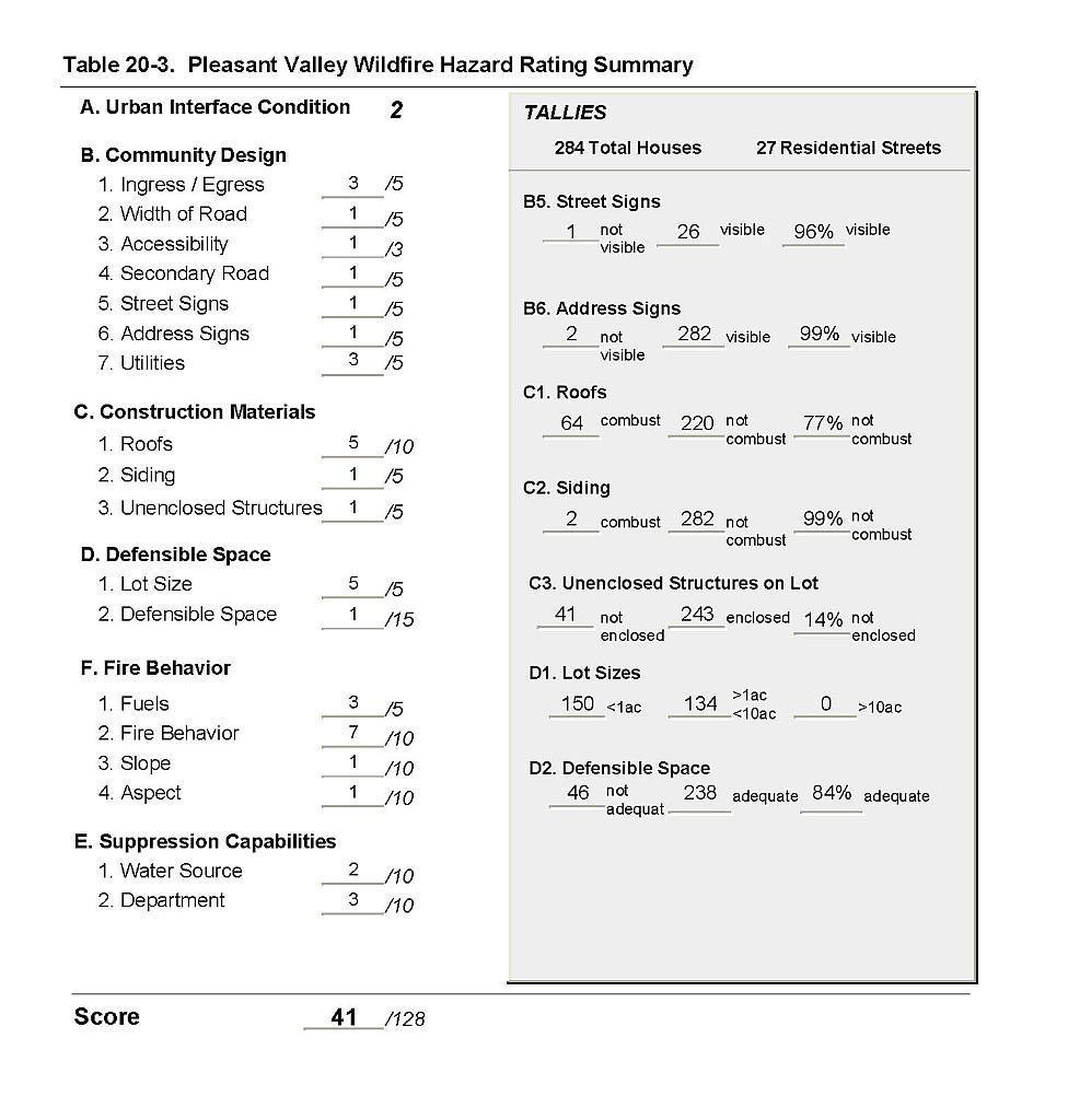 |
Figure 20-1Pleasant Valley Fire History, Suppression Resources, and Critical Features |
 |