![]()
![]()
15.0 Preston
15.1 Risk and Hazard Assessment
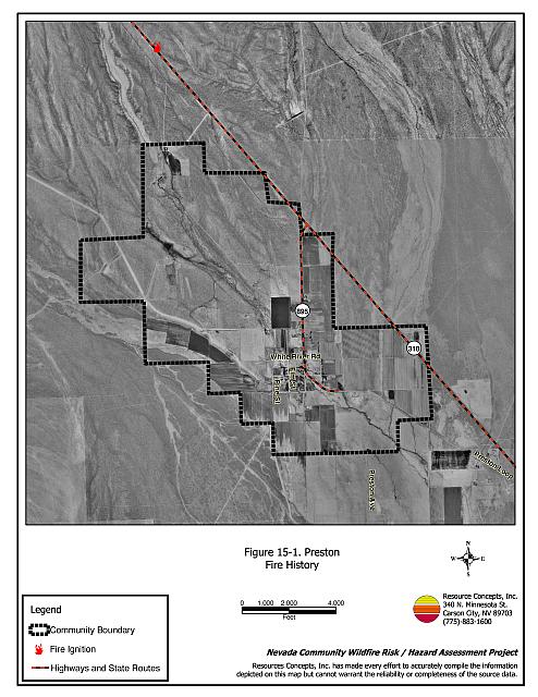
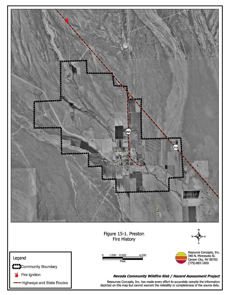
Preston is located along State Route 895, about five miles northwest of Lund. The community consists of residences surrounded by agricultural lands (see Figure 15-1). The hazard assessment resulted in classifying Preston in the Moderate Hazard Category (47 points). A summary of factors that contributed to the hazard rating is included in Table 15-2. Primary factors that determined the hazard rating for Preston were the limited street and residential signage and the lack of a local fire department.
15.1.1 Community Design
The wildland-urban interface area around Preston can best be characterized as a classic interface condition. Most of the residences are clustered in the center of the community, surrounded by agricultural fields and pastures. Most of the homes were on lots of one acre or less, with a few homes on lots of one to ten acres.
- Access: State Route 895 is the primary access road to Preston. The junction of State Route 895 and State Route 318 is located one mile north of the community. Primary and secondary community roads are all of adequate width and grade, allowing for fire suppression equipment maneuverability and two-way vehicle passage.
- Signage: None of the streets in Preston had clearly posted signs. Only 29 percent of the homes assessed had clearly visible addresses.
- Utilities: Electric utilities are all above ground and propane tanks are also located throughout the community. In some cases the minimum of ten feet of vegetation clearance was not present around propane tanks.
15.1.2 Construction Materials
All of the homes observed during the assessment were built with non-combustible or highly fire resistant siding materials such as medium density fiberboard, and all of the homes had non-combustible roofing material such as tile, metal, or composition. Only one of the homes observed had an unenclosed porch, deck, or balcony where sparks or embers can be trapped, smolder, ignite, and rapidly spread fire to the home.
15.1.3 Defensible Space
All of the homes surveyed in Preston have landscaping that meets the minimum defensible space requirement to help protect the home from damage or loss during a wildfire.
15.1.4 Suppression Capabilities
Wildfire Protection Resources
The Lund Volunteer Fire Department provides fire suppression services to Preston. Additional resources are available from the Bureau of Land Management Ely Field Office, the NDF White Pine County Fire Protection District, and the Great Basin National Park Fire Department as described in Section 4.1.1. Table 15-1 lists the types of wildfire resources, cooperating partners and equipment available to Preston to a reported wildfire.
| Type of Equipment | Amount of Equipment | Cooperating Partner |
|---|---|---|
| Engine Type 3 Engine Type 6 Water Tender Type 3 Water Tender Type 1 |
1 2 1 1 |
Lund Volunteer Fire Department |
| Source: Chief Laine Hendrix, Lund Volunteer Fire Department. | ||
Water Sources and Infrastructure
Water sources for fire protection include a ranch pond at the south end of the community and irrigation wells.
15.1.5 Factors Affecting Fire Behavior
The fuel hazard in the Preston interface area was classified as low to moderate, with fuel loads estimated at two to three tons per acre. The area east of town is entirely agricultural. The west side of town has some agricultural fields in production and some abandoned fields that have reverted to halogeton, greasewood, and rabbitbrush. Fuels surrounding the agricultural fields and pastures consist primarily of big sagebrush, greasewood, and rabbitbrush, with a grass understory of cheatgrass, halogeton, perennial grasses, and Russian thistle. Willows are present along irrigation ditches in the interior of the community. Some small isolated occurrences of high hazard fuels are present north of the community. The predominant wind direction is from the west and southwest, especially during late afternoons. The terrain is mostly flat with less than eight percent slopes.
15.1.6 Fire Behavior Worst Case Scenario
The worst-case scenario for the community of Preston would likely occur in a year with above-average production of cheatgrass. A dry lightning storm causing multiple fire ignitions to the north, east, or west side of the community could also create windy conditions that could cause the fire(s) to spread quickly toward the community. Agricultural lands in the community could slow the advance of the fire, however weeds and heavy brush accumulations along ditches could carry fire toward structures.
15.1.7 Ignition Risk Assessment
Preston has a low potential for fire ignition based on generally light fuel loading. The primary ignition risk in Preston is lightning, although human caused ignitions can happen at any time.
15.2 Risk and Hazard Reduction Recommendations
The responsibility to keep a community fire safe falls not only on the Lund Volunteer Fire Department but also on residents of the community, businesses, and local governments. Preston risk and hazard reduction recommendations focus on improving defensible space and fuel reduction treatments throughout the community. Other recommendations pertain to community coordination efforts that could be initiated to enhance the fire safe nature of Preston.
15.2.1 Defensible Space Treatments
Defensible space treatments are an essential first line of defense for residential structures. Significantly reducing or removing vegetation within a prescribed distance from structures (30 feet to 200 feet depending upon slope and vegetative fuel type) reduces fire intensity and improves firefighter and homeowner chances for successfully defending a structure against an oncoming wildfire.
Property Owners Recommendations
- Remove, reduce, and replace vegetation around homes according to guidelines provided in Appendix E. This area should be kept:
- Lean: There are only small amounts of flammable vegetation.
- Clean: There is no accumulation of dead vegetation or other flammable debris.
- Green: Existing plants are healthy and green during the fire season.
- Continue to maintain defensible space annually.
- Maintain a space clear of accumulated vegetation and combustible materials for at least ten feet around propane and fuel tanks.
- Remove heavy brush accumulations and weeds along ditch banks in the community.
- Install spark arrestors on chimneys.
- Create a firebreak of bare ground or gravel for 100 feet around stockpiled commodities. Because it is dried plant material, stacked or baled hay is vulnerable to ignition from internal combustion or outside sources.
- Plant a seed mixture of fire-resistant species around residential structures and ranch outbuildings.
- Purchase a backup power system for properties on individual wells in the case of loss of commercial power during a large wildland fire.
15.2.2 Fuel Reduction Treatments
Fuel reduction treatments are applied on a larger scale than defensible space treatments. By permanently changing the fuel structure over large blocks of land to one of lower volume or reduced flammability (a fuel reduction treatment), the expected result in the event of a catastrophic wildfire would be one of reduced risk for uncontrolled spread through the treatment area. Reducing vegetation along roadways and driveways could reduce the likelihood of wildfire spreading across roads and improve firefighter access and safety for protecting homes.
White Pine County and Nevada Department of Transportation
- Reduce vegetation by mowing it to a height of not more than four inches for a distance of 25 feet from the edge of the pavement, along both sides of county roads and State Routes. Seed or treat the cleared areas as necessary to control cheatgrass.
15.2.3 Fire Suppression Resources
Adequate training, equipment, and water drafting supplies are critical to all firefighters, whether they are first responders, volunteer fire department personnel, or agency personnel. These matters are also of special importance to all communities, especially those located in remote portions of the county. The following recommendations are related to actions the local fire department can take to increase the quality of fire suppression response in Preston.
Lund Volunteer Fire Department and Nevada Division of Forestry
- Identify agricultural wells, ponds, etc. that can be used for draft sources for fire engines and water tenders.
- Coordinate with landowners to develop a draft site on the pond located at the south end of the community.
- Install a 10,000-gallon water storage tank, well, and pump to be used to fill engines and water tenders.
15.2.4 Community Coordination
Lund Volunteer Fire Department
- Distribute copies of the publication “Living With Fire” to all property owners who live in Preston. This publication is free of charge and copies can be requested from the University of Nevada Cooperative Extension.
| Involved Party | Recommended Treatment | Recommendation Description |
|---|---|---|
| Property Owners | Defensible Space Treatments | Remove, reduce, and replace vegetation around homes, stockpiled hay, and equipment storage areas according to the guidelines in Appendix E. Maintain defensible space as needed to keep the space lean, clean, and green. |
| Nevada Department of Transportation White Pine County |
Fuel Reduction Treatment | Clear a minimum space of 25 feet from edge of pavement on both sides of county roads and state routes. |
| Nevada Division of Forestry White Pine County Lund Volunteer Fire Department |
Fire Suppression Resources | Identify agricultural wells, ponds, etc. that can be used for draft sources. Develop a drafting site on a pond on the south side of the community. Install a 10,000-gallon water storage tank and fire fill station. |
| Community Coordination | Distribute copies of the “Living With Fire” publication to residents of Preston. |
Table 15-3Preston Wildfire Hazard Rating Summary |
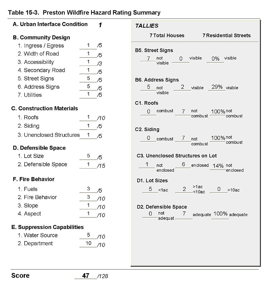 |
Figure 15-1Preston Fire History |
 |