![]()
![]()
17.0 Great Basin National Park
17.1 Risk and Hazard Assessment
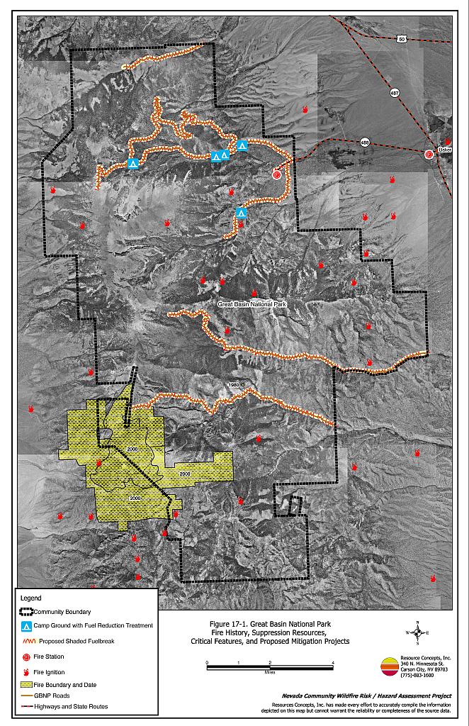
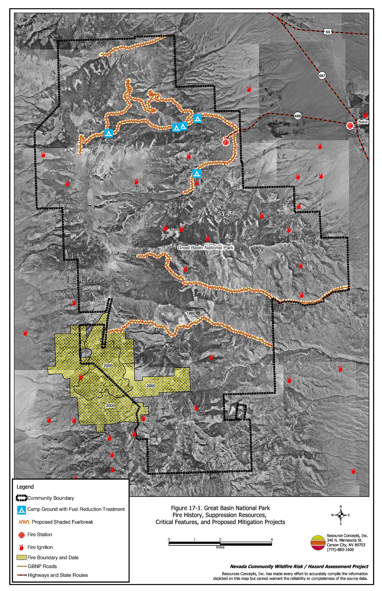
Great Basin National Park is located in southeast White Pine County (see Figure 17-1). The park covers 77,180 acres and includes special natural attractions such as Wheeler Peak, Lehman Caves, and other natural limestone caverns, abundant wildlife, and natural beauty. The park landscape includes streams, lakes, alpine plants, and a variety of forest types including groves of ancient bristlecone pines. Visitors to the park could be endangered by wildfire especially if exits from the park were blocked by fire or heavy traffic.
The park was assessed as a rural recreation community that faces potential economic or ecological losses from wildfire damage to Park resources and structures. The rural recreation community type does not lend itself to the standard community assessment procedures. Suppression resources and fuel hazard conditions are described qualitatively for the community. General recommendations for Great Basin National Park have been developed to address hazards that are unique to these developed recreational sites in remote areas.
17.1.1 Suppression Capabilities
The park has a fire department with a full time Fire Management Officer and four seasonal firefighters equipped with two Type 6 wildland fire engine; however, in general only one is staffed during the fire season. Great Basin National Park firefighters are trained to National Wildfire Coordinating Group wildland firefighting standards. Additional suppression resources are available from the Baker Volunteer Fire Department. The Ely Interagency Communication Center dispatches resources from the Bureau of Land Management and the Nevada Division of Forestry, as well as the GBNP firefighters. Water sources within the park include hydrants within 500 feet of structures such as the visitor’s center and ranger housing, wells, and small storage tanks. Gravity and electric pumps power the hydrant system. There is no backup emergency power source for the pumps.
17.1.2 Factors Affecting Fire Behavior
Vegetation in lower elevations of the park consists of pinyon, juniper, ponderosa pine, and a shrub component of sagebrush and rabbitbrush. Fuel loading in the pinyon-juniper stands is estimated at twelve to eighteen tons per acre. As elevation increases, mixed-conifer stands include ponderosa pine, white fir, Engelmann’s spruce, and Douglas fir, with lesser amounts of whitebark pine, limber pine, and quaking aspen. Some stands have an understory of mountain mahogany and young trees, and many of the stands are greatly overstocked. Drought conditions have led to fir engraver beetle infestations and subsequent tree mortality in many areas of the Park. Conifer encroachment into aspen stands is causing a loss of riparian habitat for wildlife. Forests within the Great Basin National Park are overstocked and tree mortality will continue if fuels reduction is not implemented. Standing dead trees increase fuel loading and thereby increase the wildfire hazard. A wildfire would result in wildlife habitat degradation, recreation impacts, and economic losses.
17.1.3 Worst-Case Scenario
The worst-case scenario for Great Basin National Park would be a dry lightning storm in late afternoon in June, July, or August, causing ignitions southwest or west of the park entrance. Strong downslope winds (greater than twenty miles per hour) would spread fire (or multiple fire fronts) down the mountain toward campgrounds and the Park visitor center. A fire could easily develop into an extremely hazardous crown fire. A second worst-case scenario could occur if a fire started in the heavy fuels east of the park entrance. Rapid upslope spread rates could be exhibited and exacerbated with winds from the southeast or east. Direct fire attack would be difficult to impossible. The narrow, single road access would likely slow the evacuation process. Without mitigation of the fuel hazards and access issues, both worst-case scenarios could result on loss of human life.
17.2 Risk and Hazard Reduction Recommendations
17.2.1 Evacuation Plan
The park does not have a visitor evacuation plan in the event of a wildfire. Campers and hikers at the upper elevations could be trapped if a fire started below and moved upslope. The only roads through the park are narrow one-way roads with thick vegetation along the shoulders. A fire could close off the roads and block escape routes. Public education about fire safety is critical.
- Develop an evacuation plan for all campgrounds, trails, and the visitor’s center, including information on visitor safety zones within the Park. Clearly post the plan at all campground entrances and trailheads.
- Construct turnouts on park roads for better accessibility and two-way vehicle passage.
- Design and distribute a fire safety pamphlet at the visitor’s center.
- Develop a radio activated siren system to notify visitors in case of an emergency.
17.2.2 Fuel Reduction Treatments
Permanently changing fuel structure over large blocks of land reduces the risk of a catastrophic wildfire in the treated area. Tree thinning, reduction of accumulated decadent ground fuels, and removal of standing dead trees eliminates hazardous fuels and decreases the fuel hazard in the treated area. By opening the forest floor and the tree canopy, there is less chance of a forest fire laddering from ground fuels into the tree canopy and becoming a large-scale wildfire. Fuel reduction treatments create fuelbreaks where fires burn with less intensity, and they also create a front from which firefighters can fight the fire. Thinning and removal of diseased and dead trees improve tree health because there is less competition for moisture and less potential for harboring insects.
Shaded fuelbreak specifications for the recommended treatments in the Great Basin National Park include: in the lower elevations dominated by pinyon and juniper species, thin trees to a canopy spacing of two times the height of the tree, and in the higher elevations dominated by ponderosa pine, white fir, Engleman’s spruce, and Douglas fir, thin stands to a density between 80 to 100 sq. ft. basal area.
- Develop a 600-foot wide shaded fuelbreak around all campgrounds.
- Develop a 600-foot wide shaded fuelbreak around the National Park Service housing area and visitor’s center.
- Develop 300-foot wide shaded fuelbreaks along both sides of all roads within the park.
- Remove downed logs and standing snags within the fuelbreak areas.
- Prune residual pinyon and juniper trees to four feet above the ground and other conifer species to fifteen feet above ground or no more than one-third the height of the tree.
- The biomass generated from construction of the fuelbreaks should be removed and disposed of at an appropriate site (either piled and burned or transported off the site).
- To maintain shaded fuelbreaks, conduct prescribed fires five years after the initial pile and burn and then at ten-year intervals. This will keep the fuel loading at reasonable levels, maintaining forest health and a lower level of fire hazard.
- Remove conifer tree species from within aspen stands to maintain riparian corridor habitat health. Cutting or burning within the aspen stands will help to regenerate the aspen.
| Involved Party | Recommended Treatment | Recommendation Description |
|---|---|---|
| Great Basin National Park |
Visitor Fire Safety Education | Develop and post an evacuation plan for all campgrounds, trails, and the visitor’s center. Construct turnouts on park roads for better accessibility and two-way vehicle passage. Design and distribute a fire safety pamphlet at the visitor’s center. Develop a radio activated siren system to notify visitors in case of an emergency. |
| Fuel Reduction Treatments | Develop a 600-foot wide shaded fuelbreak around all campgrounds, the NPS housing, and the visitor’s center. Develop a 300-foot wide shaded fuelbreak along both sides of all roads within the park. Remove downed logs and standing snags within the fuelbreak areas. Prune residual trees to between four and fifteen feet above the ground depending upon tree height and species. All biomass generated from shaded fuelbreak construction should be removed from the treated areas. Conduct prescribed fires five years after the initial pile and burn and then at ten-year intervals. Remove conifer trees from within aspen stands to maintain riparian corridor habitat health |
Figure 17-1Great Basin National Park Fire History, Suppression Resources, Critical Features, and Proposed Mitigation Projects |
 |