![]()
![]()
6.0 Fernley
6.1 Hazard and Risk Assessment
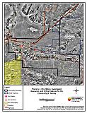
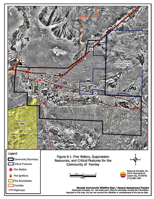
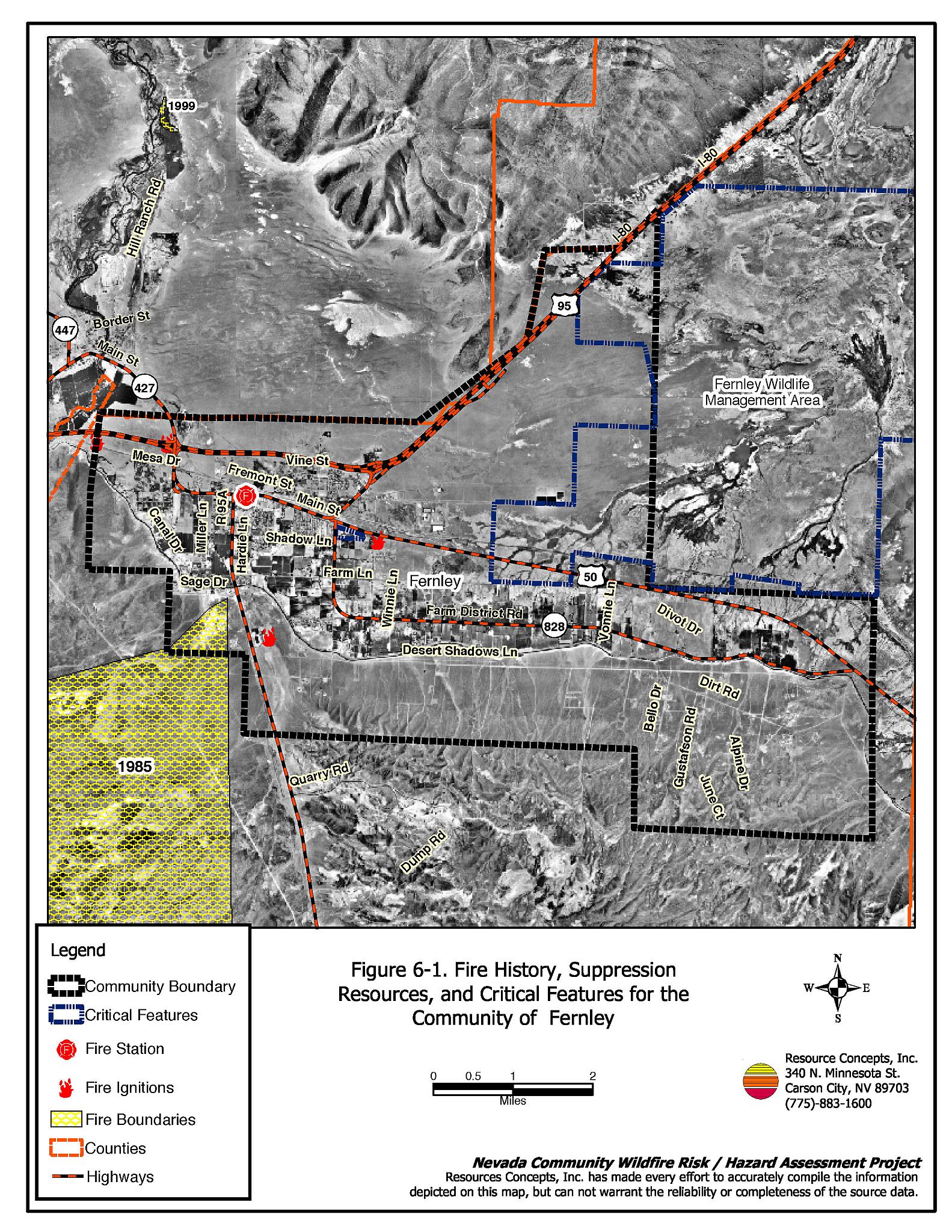
Fernley is a rapidly growing incorporated city that is situated in the north portion of Lyon County near the Truckee River and along the Truckee Canal (see Figure 6-1). The town of Fernley is bordered on the north by the Pah Rah and Truckee Ranges and on the south by the Virginia Range. The estimated population in Fernley, as of 2003, is 11,718 (Nevada State Demographers Office, 2003). The Truckee Canal dissects the town into north and south sectors. Approximately 382 residences were evaluated during the risk/hazard assessment. The risk/hazard assessment resulted in classifying Fernley in the Low Hazard category (31 points). The low community hazard rating is attributed primarily to the low fuel densities and fuel loads, fire-resistant home construction materials, and adequate defensible space. The community wildfire hazard score sheet is provided at the end of this section. The specific findings for each of the wildland fire assessment parameters are reported below.
6.1.1 Community Design
The urban interface condition in Fernley can primarily be described as classic interface. In many areas subdivisions border wildland fuels with a clear line of demarcation between the fuels and the residences. Lot sizes along the interface vary throughout Fernley with almost equal portions of lots less than one acre or between one and ten acres. A few lots sizes are large on the remaining farm/ranch lands along the Truckee River. Structure spacing varies according to lot size.
Roads: The primary access routes in Fernley are Interstate 80, Alternate US Highway 50, and US Highway 95. Interstate 80 is a paved four-lane freeway greater than 24 feet wide in each direction. Highways 50 and 95 are paved two-lane highways greater than 24 feet wide. The primary access road for residences on the south side of the Truckee Canal is Desert Shadows Lane, a dirt road greater than 24 feet wide that allows adequate room for fire suppression equipment to maneuver. Almost all of the secondary roads in the community are paved with the exception of the dirt roads south of the Truckee Canal. The majority of roads provide adequate turnaround space for fire suppression vehicles.
Signage: Most streets in Fernley have standard metal street signs that are highly visible and easy to read. Residential addresses are easily visible on a majority of homes assessed in Fernley. The clear and visible signage throughout most of Fernley will assist fire suppression personnel in locating residences during poor visibility conditions that may exist during a wildland fire.
Utilities: The above and below ground utilities and right-of-ways that serve Fernley are adequately maintained and pose only a low ignition risk to the community.
6.1.2 Construction Materials
A majority of the homes observed in the interface area were built with fire resistant siding materials. A great majority of homes had fire resistant roof materials such as composition shingles, metal, or tile roofing. About one-third of the homes observed had unenclosed balconies, porches, decks or other architectural features that can create drafty areas where sparks and embers can be trapped, smolder, and ignite, rapidly spreading fire to the home.
6.1.3 Defensible Space
The vast majority of the homes had landscaping that would meet the defensible space requirement to protect the home from damage or minimize loss during a wildfire.
6.1.4 Suppression Capabilities
Wildfire Protection Resources
The Fernley Fire Protection District (FPD) is the primary agency responsible for fire protection in Fernley. The district is a combination career and volunteer department with two career employees and 20 volunteers. The Fernley fire station location is shown in Figure 6-1. Fire suppression resources are also available throughout Lyon County through the BLM Cason City Field Office. Hand crews are available by request through the Nevada Division of Forestry. Tables 6-1 and 6-2 list the types of wildfire resources, cooperating partners, and equipment available to Fernley. The availability of the listed resources may vary depending on the time of year and the use of equipment on other assignments. The response times listed for the Fernley FPD also may vary depending upon volunteer firefighter availability.
| Type of Resource | Amount of Equipment | Cooperating Partner (Resource Location) |
|---|---|---|
| Type IV Brush Engine Water Tender Type I Engines |
1 1 2 |
Fernley Fire Protection District (Fernley) |
| Brush Engine Water Tender |
2 2 |
Central Lyon County Fire Protection District (Dayton) |
| Brush Engine Water Tender |
1 1 |
Mason Valley Fire Protection District (Yerington) |
| Crew Type II | 1 | NDF (Silver Springs or Carson City) |
| Type of Resource | Amount of Equipment | Cooperating Partner (Resource Location) |
|---|---|---|
| Single Engine Air Tanker Air Tanker Type I Type III Engines Dozer Water Tender Fire Crew |
2 2 2 2 2 1 |
The closest available BLM resources dispatched by the Sierra Front Interagency Dispatch Center in Minden. |
| Helicopter Type III Dozer Water Tender |
1 1 1 |
The closest available NDF resources dispatched by the Sierra Front Interagency Dispatch Center in Minden. |
| Brush Engine Water Tender |
2 2 |
Storey County |
| Brush Engine | 3 | East Fork Fire and Paramedic District |
| Lake Tahoe Regional Fire Strike Team (5 engines per team) |
3 | Lake Tahoe Regional Fire Chief’s Association |
| Type II Incident Management Team | 1 | Sierra Front or Great Basin Management Team, or closest available regional or national Type II Team |
| Source: Personal Communication with Fernley FPD Chief James Lemke and Fire Marshall Lee Greighlow; Leonard Wehking Fire Management Officer, BLM Carson City Field Office. | ||
Detection and Communication
Fires are reported in Lyon County through Lyon County Dispatch in Yerington and 911 calls. Fires are communicated to fire response personnel through pagers. The radio system is compatible with neighboring agencies and uses 155.100 and 154.100 frequencies. The Lyon County Sheriff’s Office also has access to the state mutual aid frequencies (NDF 159.89500, BLM 170.02500 and 155.47500).
Fire Protection Personnel Qualifications
Fire personnel in the district receive training to meet Nevada Fire Marshall standards for Entry-level Firefighters and Firefighter 1, as well as National Wildfire Coordinating Group 310-1 standards for wildland firefighters. The Fernley FPD uses the Red Card system for individual qualifications, which is part of a fire qualifications management system used by many state and all federal wildland fire management agencies that indicates an individual is qualified to fight wildland fires.
Work Load
The Fernley FPD responded to the following number and type of calls in 2003:
- 900 emergency medical
- 20 wildfires
- 320 other calls, which can include: structure fires, hazardous material, mutual aid, vehicle fires, investigations, and auto accidents.
Financial Support
Financial support for the Fernley Fire Protection District is provided through ad valorem property taxes.
Community Preparedness
The Local Emergency Planning Committee is responsible for annual updates to the county emergency and disaster plans. The BLM also has a pre-attack plan for the area that is updated annually prior to the start of each fire season. Fernley FPD reviews development plans for their district and requests that residents call them before burning. Fernley FPD is currently reviewing the possibility of utilizing a burn permit program.
Water Sources and Infrastructure
Water availability for fire suppression in Fernley includes:
- 500 gpm hydrants within 500 or 1,000 feet of structures depending upon location
- Water storage tanks of 1.5 million to 2.5 million gallon capacities
- Water drafting sources or helicopter dip sites include the Truckee Canal and the Truckee River.
The community water system operates on gravity pressure.
6.1.5 Factors Affecting Fire Behavior
Fuels on the south side of Highway 50, and north of the Truckee Canal were dominated by a shrub layer of greasewood, shadscale, and winterfat. Ground fuels consisted of bottlebrush squirreltail, Indian ricegrass, and cheatgrass. The average shrub height was approximately one to two feet with moderate spacing between plants. The fuel load in this fuel type was estimated at less than one ton per acre and was considered a low fuel hazard.
The fuels on the north and east sides of Fernley were characterized by a shrub layer of greasewood and Nevada dalea with ground fuels of Indian ricegrass and Russian thistle (tumbleweed). The light fuel load was estimated at approximately one ton per acre and was considered a low fuel hazard.
The terrain around Fernley is mostly flat within the community, however steeper mountains and foothills with slopes up to 40 percent border the north, west and south sides of the community. The predominant wind direction in the summer is from the west or southwest.
6.1.6 Fire Behavior Worst-case Scenario
The worst-case fire behavior scenario would likely occur during the afternoon of a high hazard day, during the summer months in an above normal precipitation year. Cheatgrass ground fuel would be easily ignited and rapidly spread fire into more hazardous shrub fuels. A west or southwest wind-driven fire, with the ignition point in the Virginia range west of Fernley, could spread with flame lengths of four to six feet at a rate of 1,300 to 2,000 feet per hour. A fire in this scenario could threaten the limited number of structures on the south side of the Truckee Canal. The canal acts as a firebreak for protection of residences on the north side of the Canal. If the fire began during normal working hours, there would be a limited or delayed response by volunteer firefighters that would allow time for the fire to spread. The scenario would be worsened if mutual aid resources were unavailable due to assignment to an emergency situation elsewhere. The implementation of defensible space around residences would improve structure survivability and reduce losses during a worst-case scenario fire.
6.1.7 Ignition Risk Assessment
Fernley is considered to have a low to moderate risk of human caused or lightning fire ignitions. The fire history within a five-mile radius around Fernley illustrates the low number of ignitions and the low acreage burned.
6.2 Risk and Hazard Reduction Recommendations, Roles, and Responsibilities
The responsibility to keep a community fire safe falls not only on the local fire protection district but also on the residents of the community, businesses, and local governments. The Fernley Risk/Hazard Reduction Recommendations focus primarily on additional efforts that can be taken by community members and public agencies to increase wildfire safety through reduction of hazardous fuels. Other recommendations pertain to community coordination and public education efforts that could be undertaken to enhance fire safety in Fernley. The recommendations are detailed below and summarized in Table 6-3.
6.2.1 Defensible Space Treatments
The density and type of fuel around a home affects the potential fire exposure levels to the home. The goals of defensible space are to reduce the chances of a wildfire spreading onto adjacent property and igniting homes, and to reduce the risk of loss of property from wildfire. General guidelines for creating defensible space around residences and structures in the community are given below and are described in detail in Appendix E.
Property Owner Responsibilities
- Remove, reduce, and replace vegetation to create defensible space around homes according to the guidelines in Appendix E. This area should be kept:
- Lean: There are only small amounts of flammable vegetation
- Clean: There is no accumulation of dead vegetation or other flammable debris
- Green: Existing plants are healthy and green during the fire season.
- Immediately dispose of cleared vegetation when implementing defensible space treatments. This material dries quickly and poses a fire hazard if left on site.
- Maintain defensible space annually or as needed to keep the space lean, clean, and green.
- Mow or remove brush growing against wood fences in the community.
- Maintain areas under wood decks and porches free of weeds and other flammable debris. Install screens around unenclosed overhangs where possible.
- Store firewood a minimum distance of 30 feet from structures.
- Clear all vegetation and combustible materials around propane tanks for a minimum distance of 10 feet.
6.2.2 Community Coordination
Coordination among local, state, and federal fire suppression agencies is important in the day-to-day fire prevention activities and becomes critical in the event of a wildland fire. During a wildfire event, firefighters from other communities and states may be dispatched to protect areas they have never been before. This is particularly true in areas that have limited fire suppression resources and will most likely depend on outside assistance in the event of a catastrophic wildland fire. The following recommendations should be implemented in Fernley to enhance interagency and community coordination.
Property Owner Responsibilities
- Form a local chapter of the Nevada Fire Safe Council. The Nevada Fire Safe Council facilitates solutions to reduce the loss of lives and property from the threat of wildfire in Nevada’s communities. Through the establishment of a local chapter, local communities will become part of a large network for sharing information and receive notifications of programs and funding opportunities for fire mitigation projects such as those listed in this report. The Nevada Fire Safe Council will accept and manage grants and contracts on the chapter’s behalf through its non-profit status. The Nevada Fire Safe Council will provide assistance and support to communities to complete fire safe plans, set priorities, educate and train community members, and promote success stories of its members. To form a local chapter, or for more information contact the:
Nevada Fire Safe Council
1187 Charles Drive
Reno, Nevada 89509
(775) 322-2413
www.nvfsc.org - Assure that residential addresses are visible from the road. Address characters should be at least four inches high, reflective, and composed of non-flammable material. Improving visibility of addresses will make it easier for those unfamiliar with the area to navigate under smoky conditions during a wildland fire.
Fernley Fire Protection District Responsibilities
- Meet annually with the Sierra Front Wildfire Cooperators to discuss their pre-attack plan for the community.
6.2.3 Public Education
Increased public education on fire safety is critical in communities that have rapidly growing populations, especially when many of the areas being developed are larger lots intermixed with wildland fuels. People moving into the area may be unfamiliar with fire-prone environments.
Fernley Fire Protection District Responsibilities
- Distribute copies of the publication Living with Fire to all property owners. This publication is free of charge. Copies can be requested from the University of Nevada Cooperative Extension.
- Enforce or develop county laws, regulations, and ordinances that support implementation and maintenance of defensible space and address fuel reduction responsibilities for absentee homeowners and vacant lots.
- Contact the University of Nevada Cooperative Extension and the BLM Carson City Field Office for assistance with public education.
6.3 Summary of Recommendations
| Responsible Party | Recommended Treatment | Recommendation Description |
|---|---|---|
| Property Owners | Defensible Space Treatments | Remove, reduce, and replace vegetation around homes according to the guidelines in Appendix E. Maintain defensible space as needed to keep the space lean, clean, and green. Expand the use of address and street signage where needed. |
| Community Coordination | Form a local chapter of the Nevada Fire Safe Council. | |
| Fernley Fire Protection District | Community Coordination | Meet annually with the Sierra Front Wildfire Cooperators to discuss the pre-attack plans for the community. |
| Public Education | Distribute copies of the publication Living with Fire to all property owners. Enforce or develop county laws and ordinances for defensible space and fuel reduction that include responsibilities for absentee owners and vacant lots. Contact the Nevada Cooperative Extension and the BLM for assistance with public education. |
Figure 6-1Fire History, Suppression Resources, and Critical Features for the Community of Fernley |
 |
Fernley Wildfire Hazard Rating Summary |
 |