![]()
![]()
12.0 Silver Springs
12.1 Hazard and Risk Assessment
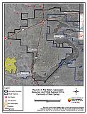
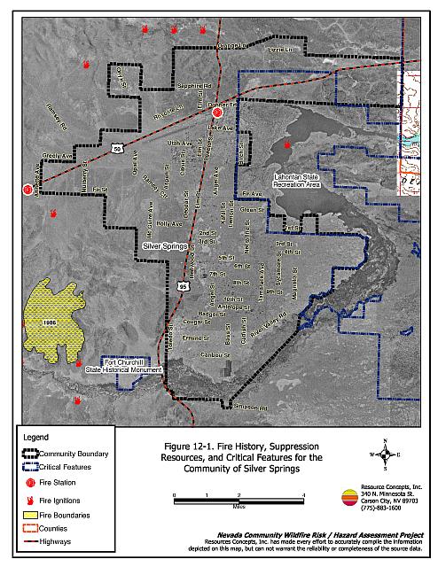
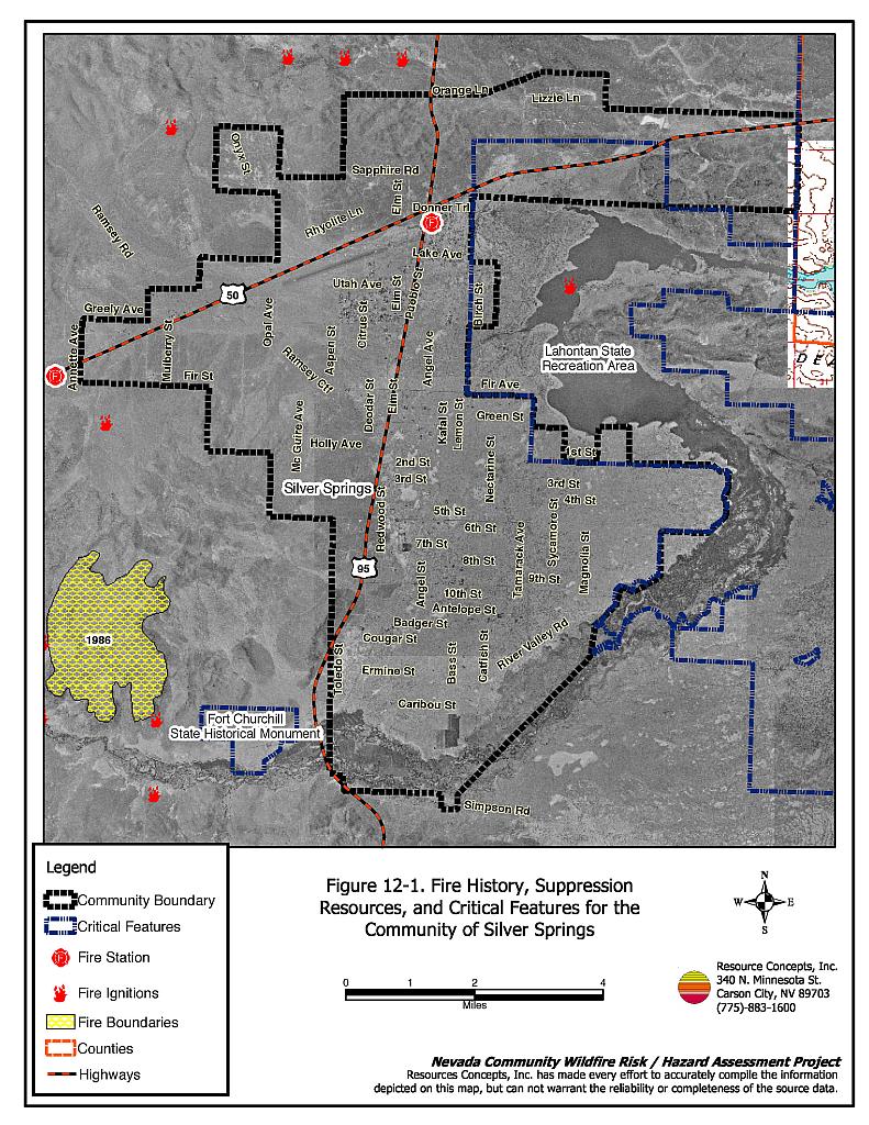
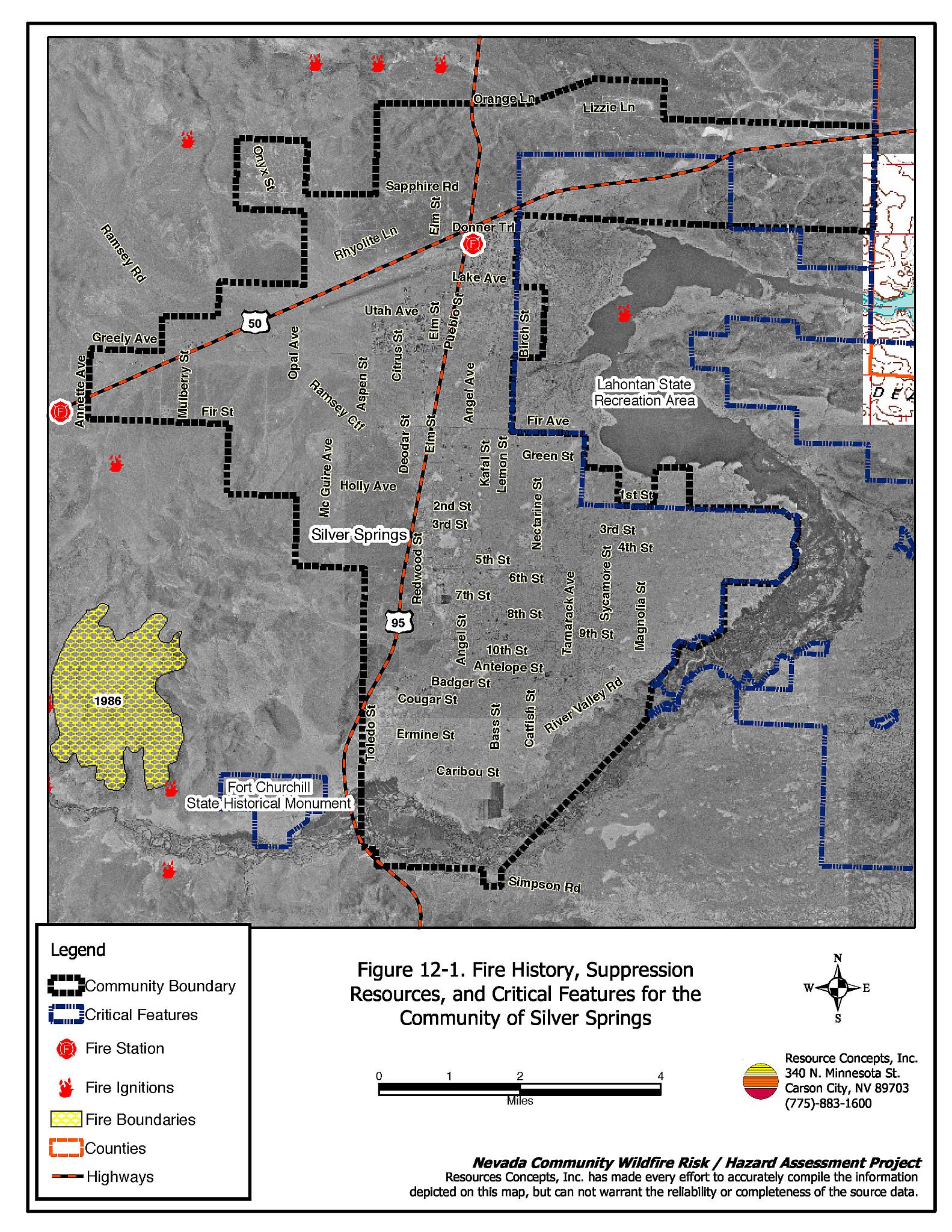
Silver Springs is a rapidly growing community located in the north-central portion of Lyon County in Churchill Valley, sometimes known as Stockton Flat (see Figure 12-1). The valley is bordered on the north by the Virginia Range and on the south by the Carson River. The estimated population in Silver Springs as of 2000 was 4,708 (US Census Bureau, 2000). Approximately 1,562 residences were evaluated during the assessment. The risk/hazard assessment resulted in classifying Silver Springs in the Low Hazard category (39 points). The low community hazard rating is attributed primarily to adequate accessibility, fire suppression resources, fire-resistant construction materials, and defensible space around homes. The community wildfire hazard score sheet is provided at the end of this section. The specific findings for each of the wildland fire assessment parameters are reported below.
12.1.1 Community Design
The urban interface condition in Silver Springs can be described as predominantly intermix, where homes have been built on large lots with wildland fuels often contiguous up to each residence. Lot sizes vary throughout Silver Springs with the majority of lots between one and ten acres in size. Structure spacing varies according to lot size and shape.
Roads: The primary access routes in Silver Springs are US Highway 50 and US Highway 95. The highways are paved and greater than 24 feet wide and provide adequate room for fire suppression equipment access. The road gradient is less than five percent for all primary and secondary roads.
Signage: Most streets in Silver Springs have standard metal street signs that are highly visible and easy to read. Residential addresses are easily visible on about three-quarters of homes in Silver Springs. Clear and visible signage is important to assist fire suppression personnel in locating residences during poor visibility conditions that may exist during a wildland fire.
Utilities: The utilities that serve Silver Springs are predominantly above ground power lines and above ground propane. In general, above ground power lines have adequately maintained right-of-ways and pose only a low ignition risk to the community.
12.1.2 Construction Materials
A majority of the homes observed in the interface area were built with fire resistant siding materials. A great majority of the homes had fire resistant roof materials such as composition shingles, metal, or tile roofing. About one-fourth of the homes observed had unenclosed balconies, porches, deck or other architectural features that can create drafty areas where sparks and embers can be trapped, smolder, and ignite, rapidly spreading fire to the home.
12.1.3 Defensible Space
The vast majority of the homes had landscaping that would meet the defensible space landscape requirement to protect the home from damage or minimize loss during a wildfire.
12.1.4 Suppression Capabilities
Wildfire Protection Resources
The location of the Silver Springs fire station is shown in Figure 12-1. Wildfire protection is provided by the Central Lyon County Fire Protection District. Refer to Section 4.2 for more information on equipment and resources available.
Water Sources and Infrastructure
Water availability for fire suppression in Silver Springs includes:
- Community wells
- 500 gpm hydrants within 300 feet of commercial structures near the intersection of US Highways 95 and 50, and
- A 300,000 gallon water storage tank
The community water system operates on gravity and electric pumps. There is no backup generator for the water system.
12.1.5 Factors Affecting Fire Behavior
The fuel type in the vicinity of Silver Springs was characterized by salt desert shrub vegetation. The dominant shrubs included greasewood, Lahontan sagebrush, and Nevada dalea. Shrubs were generally spaced five to twenty feet apart. Dominant ground fuels included Indian ricegrass, cheatgrass, and Russian thistle. The estimated fuel load in this fuel type was less than one-half ton per acre and was considered a low fuel hazard.
The fuels along the Carson River at the south end of Silver Springs were dominated by black greasewood. Other shrubs included sagebrush and rabbitbrush. The shrub height was generally between two and five feet, and shrubs were spaced between three and 30 feet apart. The tree canopy layer was comprised of willow, Russian olive, and cottonwood. The ground fuels consisted of saltgrass and bottlebrush squirreltail. The total fuel load along the river corridor was estimated to be two tons per acre and was classified as a low to moderate fuel hazard.
The terrain around Silver Springs is generally flat with slopes less than five percent. Steep foothills and mountains occur north, west, and south of the community. Lake Lahontan is located east of the community. The predominant wind direction is from the west or southwest, with downslope winds possible on the east aspects.
12.1.6 Fire Behavior Worst-case Scenario
The flat topography around Silver Springs is not a contributing factor in the worst-case scenario. The worst-case scenario for fire behavior would likely occur on a high hazard summer day. A man-caused or lightning ignition west or northwest of the community in the Virginia Range foothills could rapidly spread toward the community pushed by erratic winds 20 to 30 miles per hour. Typical flame lengths could range from four to ten feet spreading fire at rates of 1,300 to 2,600 feet per hour. The light fuel loads and adequate defensible space around homes in the community would slow fire spread and aid in suppression activities in the event of the worst-case scenario.
12.1.7 Ignition Risk Assessment
Silver Springs was viewed as having a low risk of fire ignition from either man-caused or lightning sources.
12.2 Risk and Hazard Reduction Recommendations, Roles, and Responsibilities
The responsibility to keep a community fire safe falls not only on the local fire protection district but also on the residents of the community, businesses, and local governments. The recommendations for Silver Springs focus primarily on additional efforts that can be taken by community members and public agencies to increase wildfire safety through reduction of hazardous fuels. Other recommendations pertain to community coordination and public education efforts that would enhance fire safety in Silver Springs. The following recommendations are detailed below and summarized in Table 12-1.
12.2.1 Community Coordination
Coordination among local, state, and federal fire suppression agencies is important in the day-to-day fire prevention activities and becomes critical in the event of a wildland fire. During a wildfire event, firefighters from other communities and states maybe dispatched to protect areas they have never been before. This is particularly true in areas that have limited fire suppression resources and will most likely depend on outside assistance in the event of a catastrophic wildland fire. The following recommendations should be implemented in Silver Springs to promote interagency and community coordination.
Property Owner Responsibilities
- Assure that residential addresses are visible from the road. Address characters should be at least four inches high, reflective, and composed of non-flammable material. Improving visibility of addresses will make it easier for those unfamiliar with the area to navigate an area during a wildland fire under smoky conditions.
12.2.2 Public Education
Increased public education on fire safety is critical in communities that have rapidly growing populations, especially when many of the areas being developed are larger lots intermixed with wildland fuels. People moving into the area may be unfamiliar with fire-prone environments.
Central Lyon County Fire Protection District Responsibilities
- Distribute copies of the publication Living with Fire to all property owners. This publication is free of charge. Copies can be requested from the University of Nevada Cooperative Extension.
- Enforce or develop county laws, regulations, and ordinances that support implementation and maintenance of defensible space and address fuel reduction responsibilities for absentee homeowners and vacant lots.
12.3 Summary of Recommendations
| Responsible Party | Recommended Treatment | Recommendation Description |
|---|---|---|
| Property Owners | Community Coordination | Improve address visibility. |
| Central Lyon County Fire Protection District | Public Education | Distribute copies of the publication Living with Fire to all property owners. Enforce or develop county laws and ordinances for defensible space and fuel reduction that include responsibilities for absentee owners and vacant lots. |
Figure 12-1Fire History, Suppression Resources, and Critical Features for the Community of Silver Springs |
 |
Silver Springs Wildfire Hazard Rating Summary |
 |