![]()
![]()
13.0 Smith Valley
13.1 Hazard and Risk Assessment
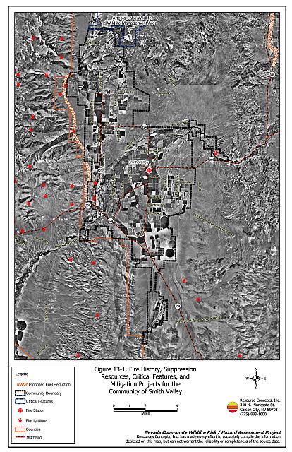
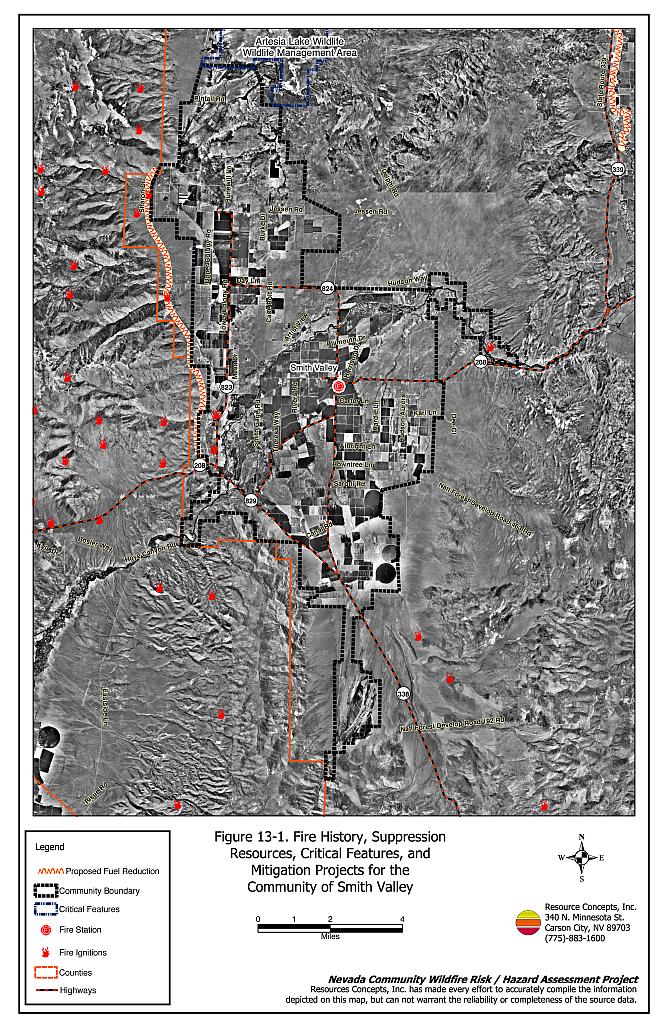
Smith Valley is located in southwest Lyon County. The valley is bordered to the west by the Pine Nut Mountains, to the south by the Wellington and Pine Grove Hills, to the east by the Singatse Range, and to the north by the Buckskin Range (see Figure 13-1). The West Fork of the Walker River dissects the town into north and south sectors. The estimated population in Smith Valley as of 2000 was 1,425 (US Census Bureau, 2000). Smith Valley includes the towns of Wellington and Smith. A total of 344 residences in the urban interface were evaluated during the assessment. The risk/hazard assessment resulted in classifying Smith Valley in the Moderate Hazard category (54 points). The overall moderate community hazard rating is attributed primarily to community design, large lot sizes, and fire-resistant building materials. If evaluated separately, the west side of Smith Valley would score in the High Hazard categorydue to the high to extreme fuel hazard.The community wildfire hazard rating score sheet is provided at the end of this section. The specific findings for each of the wildland fire assessment parameters are reported below.
13.1.1 Community Design
The urban interface condition in Smith Valley is primarily intermix, where homes have been built on larger lots and wildland fuels are often continuous up to each residence. Lot sizes vary throughout Smith Valley with the majority of lots between one and ten acres and a smaller number less than one acre in size. Structure spacing varies according to lot size.
Roads: The primary access routes in Smith Valley are State Route 208 and State Route 338. Both primary roads are greater than 24 feet wide and allow adequate room for fire suppression equipment to maneuver. Almost all of the primary and secondary roads have grades less than five percent. Most of the secondary roads are longer than 200 feet, or driveways are longer than 600 feet and do not have adequate turn-around space for fire suppression vehicles to maneuver.
Signage: Most streets in Smith Valley have standard metal street signs that are highly visible and easy to read. Residential addresses are easily visible on a majority of homes in Smith Valley. The clear and visible signage throughout Smith Valley will assist fire suppression personnel in locating residences during poor visibility conditions that may exist during a wildland fire.
Utilities: The utilities that serve Smith Valley are primarily above ground power lines and above ground propane tanks. In general utilities have adequately maintained right-of-ways and pose only a low ignition risk to the community.
13.1.2 Construction Materials
A majority of the homes observed in the interface area were built with fire resistant siding materials. A great majority of homes had fire resistant roof materials such as composition shingles, metal, or tile roofing. Few homes were observed with unenclosed balconies, porches, decks or other architectural features that can create drafty areas where sparks and embers can be trapped, smolder, and ignite, rapidly spreading fire to the home.
13.1.3 Defensible Space
The majority of the homes had landscaping that would meet the defensible space requirement to protect the home from damage or minimize loss during a wildfire. The exception is the homes on the west side of Smith Valley adjacent to pinyon-juniper fuels and steep slopes that require increasing the width of the defensible space zone as shown in Appendix E.
13.1.4 Suppression Capabilities
Wildfire Protection Resources
The Smith Valley Fire Protection District (FPD) is the primary agency responsible for fire protection in Smith Valley. Smith Valley FPD is an entirely volunteer department with approximately 15 members. The location of the Smith Valley fire station is shown in Figure 13-1. Resources available for initial attack are shown in Tables 13-1 and 13-2. The availability of the listed resources depends on the time of year and deployment of crews and equipment to other incidents.
| Resource | Amount of Equipment | Cooperating Partner (Resource Location) |
|---|---|---|
| Brush Engine Type III Type I Engine Water Tender Type I |
2 1 1 |
Smith Valley Fire Protection District (Smith) |
| Type IV Brush Engine Water Tender Type I Engines |
1 1 2 |
Fernley Fire Protection District (Fernley) |
| Brush Engine Type 1 Engine Water Tender |
1 1 1 |
Mason Valley Fire Protection District (Yerington) |
| Crew Type II | 1 | NDF (Silver Springs or Carson City) |
| Type of Resource | Amount of Equipment | Cooperating Partner (Resource Location) |
|---|---|---|
| Single Engine Air Tanker Air Tanker Type I Type III Engines Dozer Water Tender Fire Crew |
2 2 2 2 1 1 |
The closest available BLM resources dispatched by the Sierra Front Interagency Dispatch Center in Minden. |
| Helicopter Type III Dozer Water Tender |
1 1 1 |
The closest available NDF resources dispatched by the Sierra Front Interagency Dispatch Center in Minden. |
| Brush Engine Water Tender Type I Engine |
5 5 3 |
East Fork Fire and Paramedic District (Minden) |
| Lake Tahoe Regional Fire Strike Team (5 engines per team) |
3 | Lake Tahoe Regional Fire Chief’s Association |
| Type II Incident Management Team | 1 | Sierra Front or Great Basin Management Team (Region 4) |
| Source: Personal Communication with Smith Valley Fire Protection District Chief Jim Hard; Leonard Wehking Fire Management Officer, BLM Carson City Field Office. | ||
Detection and Communication
Fires are reported in Lyon County through Lyon County Dispatch in Yerington and 911 calls. Fires are communicated to fire response personnel through radio and pagers. The radio system primary frequency is 155.100 and tactical frequency is 155.925 and both are compatible with neighboring agencies. There are gaps in the radio coverage over Sweetwater Summit. The Lyon County Sheriff’s Office also has access to the state mutual aid frequencies (NDF 159.89500, BLM 170.02500 and 155.47500).
Fire Protection Personnel Qualifications
Fire personnel in the district receive training through a system developed specifically for the Smith Valley Fire Protection District. The district does not use the Red Card system for individual qualifications; however, many members have obtained red card certification through other agencies.
Work Load
The Smith Valley Fire Protection District responded to the following number and type of calls in 2003.
- 40 emergency medical
- 15 wildfires
- 5 other
Financial Support
Financial support for the Smith Valley Fire Protection District is provided through ad valorem and consolidated tax distribution.
Community Preparedness
The Lyon County Local Emergency Planning Committee is responsible for annual updates to the county disaster and emergency plans. The BLM Carson City Field Office has a pre-attack plan for the area. This plan is updated annually prior to the start of each fire season. The Smith Valley Fire Protection District reviews development plans for their district. The district brush clearance program is not consistently enforced.
Water Sources and Infrastructure
Water availability for fire suppression in Smith Valley includes:
- Two storage tanks, 1,000 gallons each;
- Local ponds and irrigation canals that can be used as a drafting or dip sites with the permission of the property owner; and
- West fork of the Walker River that can be used as a drafting or dip site.
13.1.5 Factors Affecting Fire Behavior
The fuels along the east side of Smith Valley were composed of sagebrush, spiny hopsage, shadscale, Mormon tea, budsage, and littleleaf horsebrush. Grasses included Indian ricegrass, bottlebrush squirreltail, and cheatgrass. Shrub heights ranged between two and five feet. Spacing between shrub canopies averaged two to five feet. The estimated fuel load in this fuel type was two to three tons per acre and was considered a moderate to high fuel hazard.
The fuels on the west side of Smith Valley were sagebrush, pinyon, and juniper. Pinyon and juniper trees comprised the tree fuel layer with heights up to 30 feet. The shrub layer included sagebrush, desert peach, and Mormon tea. Shrubs were densely spaced with only two to five feet between canopies. Bottlebrush squirreltail and cheatgrass were the dominant ground fuels in the area. The total fuel load on the west side of Smith Valley was estimated to be six to ten tons per acre and was classified as a high to extreme fuel hazard.
At the south end of the valley the fuels were lighter and dominated by low sagebrush. Ground fuels in this area included bottlebrush squirreltail, Sandberg bluegrass, and cheatgrass. The low sagebrush shrubs were approximately one foot in height and were densely spaced at one to two feet between canopies. The estimated fuel loads was one-half ton per acre and was considered a low fuel hazard.
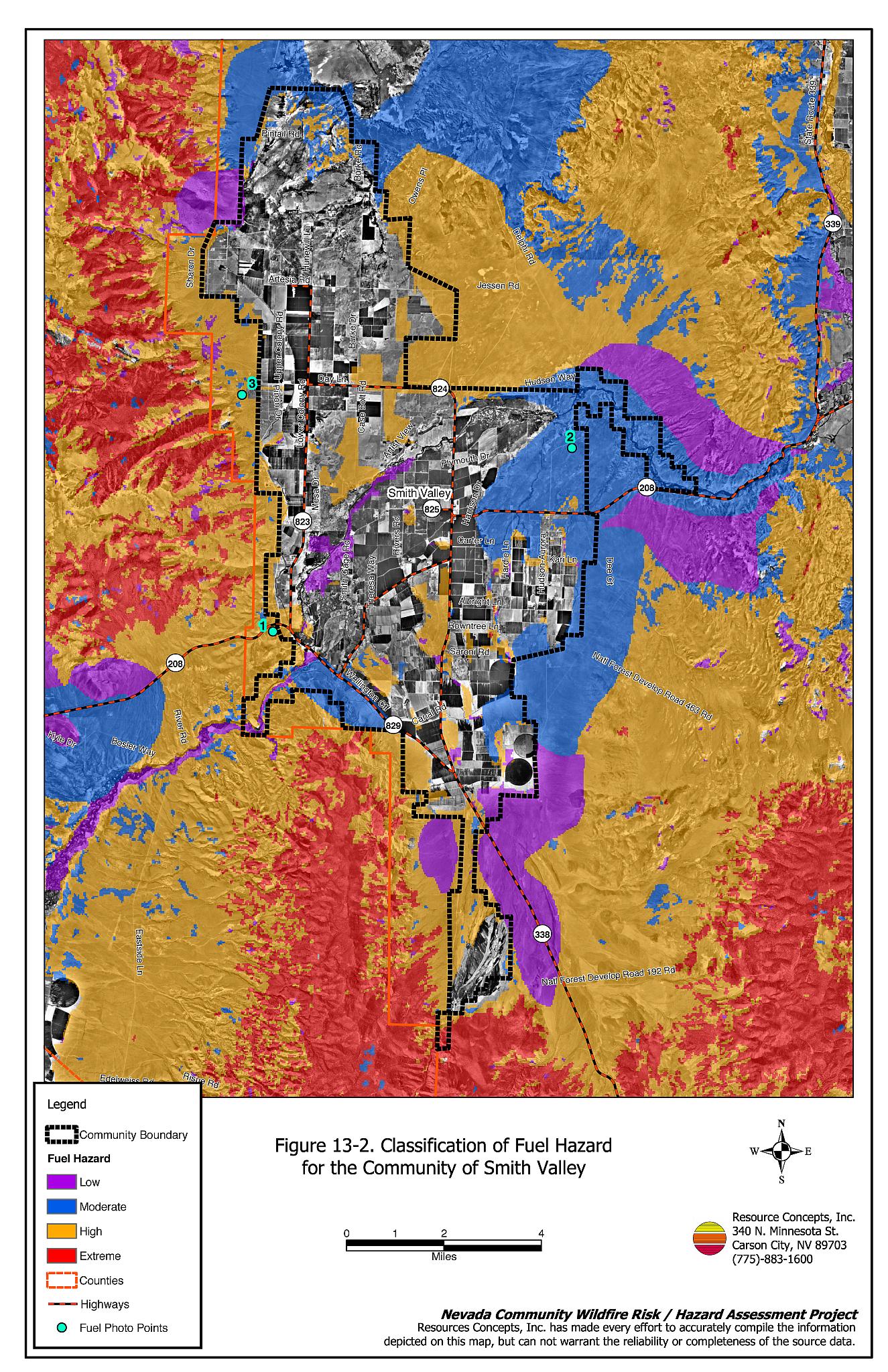
Fuels along the West Fork of the Walker River were characterized by an overstory of cottonwood trees with salt desert shrub understory. The dominant shrubs included black greasewood, four-wing saltbush, and silver buffaloberry. Shrub spacing was sparse at approximately five to 25 feet between plants. Shrub heights were approximately four to five feet tall. Saltgrass was the dominant ground fuel in the area. The estimated fuel load along the river was two tons per acre and was considered a moderate fuel hazard. Fuel hazard mapping and photo point locations are shown in Figure 13-2. Fuel hazard photos are shown in Figure 13-3 at the end of this section.
13.1.6 Fire Behavior Worst-case Scenario
The worst-case fire behavior scenario would likely occur on the west side of Smith Valley near Upper Colony Road. A lightning strike ignition in the afternoon of a high hazard day in the summer could rapidly spread if driven by west, southwest, or downslope winds. The steep slopes, narrow canyons, and limited access in the area would make initial attack difficult. Flame lengths of a wind-driven fire in this fuel type could reach ten to thirty feet in length spreading fire at an estimated rate of 2,600 to 3,960 feet per hour. The limited number of volunteer fire personnel and potential rapid spread rates could allow the fire to escape initial attack and threaten nearby homes.
13.1.7 Ignition Risk Assessment
Smith Valley has a high risk of lightning-caused fire ignition.
13.2 Risk and Hazard Reduction Recommendations, Roles, and Responsibilities
The responsibility to keep a community fire safe falls not only on the local fire protection district but also on the residents of the community, businesses, and local governments. The Smith Valley Risk/Hazard Reduction Recommendations focus primarily on additional efforts that can be taken by community members and public agencies to increase wildfire safety through reduction of hazardous fuels. Other recommendations pertain to community coordination and public education efforts that could be undertaken to enhance fire safety in Smith Valley. The recommendations are detailed below and summarized in Table 13-3.
13.2.1 Defensible Space Treatments
The density and type of fuel around a home affects the potential fire exposure levels to the home. The goals of defensible space are to reduce the chances of a wildfire spreading onto adjacent property and igniting homes, and to reduce the risk of property loss from wildfire. General guidelines for creating defensible space around residences and structures in the community are given below and are described in detail in Appendix E.
Property Owner Responsibilities
- Remove, reduce, and replace vegetation to create defensible space around homes according to the guidelines in Appendix E. This area should be kept:
- Lean: There are only small amounts of flammable vegetation
- Clean: There is no accumulation of dead vegetation or other flammable debris
- Green: Existing plants are healthy and green during the fire season.
- Immediately dispose of cleared vegetation when implementing defensible space treatments. This material dries quickly and poses a fire hazard if left on site.
- Maintain a minimum clearance of 30 feet from the crown of trees that remain within the defensible space zone. Keep this area free of smaller trees, shrubs, and other ladder fuels.
- Trim and remove tree branches a minimum of four feet from the ground to reduce ladder fuels on all deciduous and coniferous trees within the defensible space zone. Prune all dead and diseased branches.
- Prune trees so that the branches are at least 15 feet away from chimneys and or structures.
- Store firewood a minimum distance of 30 feet from structures.
- Install spark arrestors on chimneys.
- Mow or remove brush growing against wood fences in the community.
- Maintain areas under wood decks and porches free of weeds and other flammable debris. Install screens around unenclosed overhangs where possible.
- Clear all vegetation and combustible materials around propane tanks for a minimum distance of ten feet.
- Maintain defensible space as needed to keep the space lean, clean, and green.
13.2.2 Fuel Reduction Treatments
The following fuel reduction treatments are recommended to reduce the potential fire hazard and aid fire suppression activities within the wildland-urban interface on the west side of Smith Valley.
Property Owner Responsibilities
- Reduce fuels along driveways to provide firefighters safe access to the home. Mow or thin shrubs at least ten feet on each side of driveways that are longer than 200 feet in length. Where possible, replace native vegetation with more fire resistant species (irrigated lawn, deciduous shrubs, wildflowers, crested wheatgrass, etc.). Appendix E contains additional information on seed mixes and planting guidelines.
Bureau of Land Management Responsibilities
- Create a shaded fuelbreak on the west side of the community, west of Upper Colony Road from State Route 208 north to Nevada Hot Springs. The fuelbreak should be 200 to 300 feet wide depending upon topography and fuel type. Approximate length of the fuel break is eight miles (for a total treatment area of approximately 190 to 290 acres). Remove brush using masticator or brush beater type equipment. Thin trees to a spacing of one and one-half time the height of the trees between crowns. Prune limbs of remaining trees four to five feet from ground level. Broadcast seed the area using an appropriate seed mix for the area.
13.2.3 Community Coordination
Coordination among local, state, and federal fire suppression agencies is important in the day-to-day fire prevention activities and becomes critical in the event of a wildland fire. During a fire event, firefighters from other communities and states may be dispatched to protect areas they have never been before. This is particularly true in areas that have limited fire suppression resources and will most likely depend on outside assistance in the event of a catastrophic wildland fire. The following are recommendations should be implemented in Smith Valley to promote interagency and community coordination.
Property Owner Responsibilities
- Form a local chapter of the Nevada Fire Safe Council. The Nevada Fire Safe Council facilitates solutions to reduce the loss of lives and property from the threat of wildfire in Nevada’s communities. Through the establishment of a local chapter, local communities will become part of a large network for sharing information and receive notifications of programs and funding opportunities for fire mitigation projects such as those listed in this report. The Nevada Fire Safe Council will accept and manage grants and contracts on the chapter’s behalf through its non-profit status. The Nevada Fire Safe Council will provide assistance and support to communities to complete fire safe plans, set priorities, educate and train community members, and promote success stories of its members. To form a local chapter, or for more information contact the:
Nevada Fire Safe Council
1187 Charles Drive
Reno, Nevada 89509
(775) 322-2413
www.nvfsc.org - Assure that residential addresses are visible from the road. Address characters should be at least four inches high, reflective, and composed of non-flammable material. Improving visibility of addresses will make it easier for those unfamiliar with the area to navigate an area during a wildland fire under smoky conditions.
Smith Valley Fire Protection District Responsibilities
- Meet annually with the Bureau of Land Management to discuss their pre-attack plan for the community.
- Enforce or help develop county laws, regulations, and ordinances that support implementation and maintenance of defensible space, and address fuel reduction responsibilities for absentee homeowners and vacant lots.
- Contact the University of Nevada Cooperative Extension and the BLM Carson City Field Office for assistance with public education.
13.2.4 Public Education
Increased public education on fire safety is critical in communities that have rapidly growing populations, especially when many of the areas being developed are larger lots intermixed with wildland fuels. People moving into the area may be unfamiliar with fire-prone environments.
Smith Valley Fire Protection District Responsibilities
- Distribute copies of the publication Living with Fire to all property owners. This publication is free of charge. Copies can be requested from the University of Nevada Cooperative Extension.
13.3 Summary of Recommendations
| Responsible Party | Recommended Treatment | Recommendation Description |
|---|---|---|
| Property Owners | Defensible Space Treatments | Remove, reduce, and replace vegetation around homes according to the guidelines in Appendix E. Maintain defensible space as needed to keep the space lean, clean, and green. |
| Fuel Reduction Treatments / Access | Reduce, remove, or replace vegetation within ten feet on each side of driveways longer than 200 feet in length. | |
| Community Coordination | Form a local chapter of the Nevada Fire Safe Council. Improve address visibility. |
|
| BLM | Fuel Reduction Treatments | Create a fuelbreak on the west side of Smith Valley, approximately eight miles long and 200 to 300 feet wide. |
| Smith Valley Fire Protection District | Community Coordination | Meet annually with the Bureau of Land Management to discuss their pre-attack plan for the community. Enforce or develop county laws and ordinances for defensible space and fuel reduction responsibilities for absentee owners and vacant lots. |
| Public Education | Distribute copies of the publication Living with Fire to all property owners. Contact Nevada Cooperative Extension and the BLM for assistance with public education. |
Figure 13-1Fire History, Suppression Resources, Critical Features, and Mitigation Projects for the Community of Smith Valley |
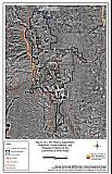 |
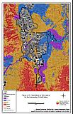
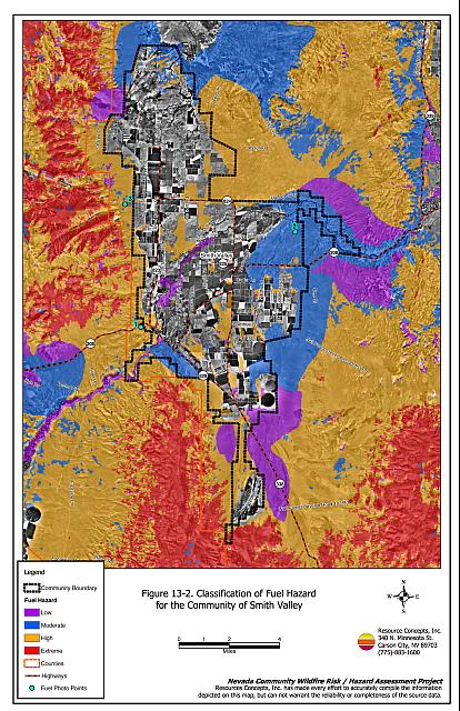
Figure 13-2Classification of Fuel Hazard for the Community of Smith Valley |
 |
Fuel Hazard Photo Points for the Smith Valley Community

Photo Point 1. 4293372 N. 0291852 E. Direction 350° NW. At the south end of the valley the fuels are lighter due to dominance by low sagebrush plant communities. Ground fuels in this area are composed of bottlebrush squirreltail, Sandberg bluegrass, and cheatgrass. The estimated fuel loads is 0.5 tons per acre and is considered a low fuel hazard.

Photo Point 2. 4299439 N. 0301735 E. Direction 345°NW. The fuels along the east side of Smith Valley are composed of desert shrub vegetation. Predominant shrub species include sagebrush, spiny hopsage, shadscale, Mormon tea, bud sage, and littleleaf horsebrush. Dominant grass species include Indian ricegrass, bottlebrush squirreltail, and cheatgrass. Estimated fuel load in this fuel type is two to three tons per acre and is considered a moderate to high fuel hazard.
Photo Point 3. 4301201 N. 0290083 E. Direction 270° W. On the west side of Smith Valley pinyon and juniper trees comprise the tree fuel layer with heights up to 30 feet. The shrub canopy includes sagebrush, desert peach, and Mormon tea. Bottlebrush squirreltail and cheatgrass are the dominant ground fuels in the area. The total fuel load on the west side is estimated to be six to ten tons per acre and classified as a high to extreme fuel hazard.
The left side of this photo depicts the pinyon juniper fuel type that has been treated for defensible space. Trees and shrubs have been thinned, and the fence line has been cleared. The right side of this photo shows the untreated, hazardous fuel condition.
Smith Valley Community Wildfire Hazard Rating Summary |
 |