![]()
![]()
14.0 Stagecoach
14.1 Hazard and Risk Assessment
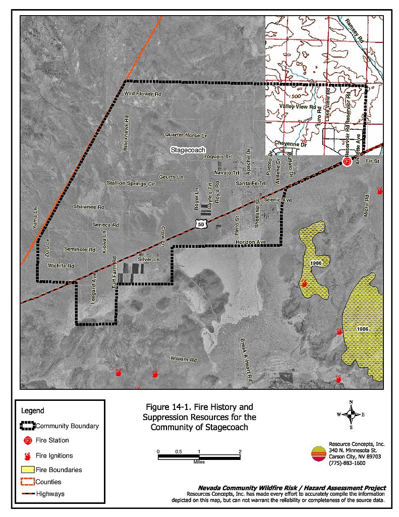
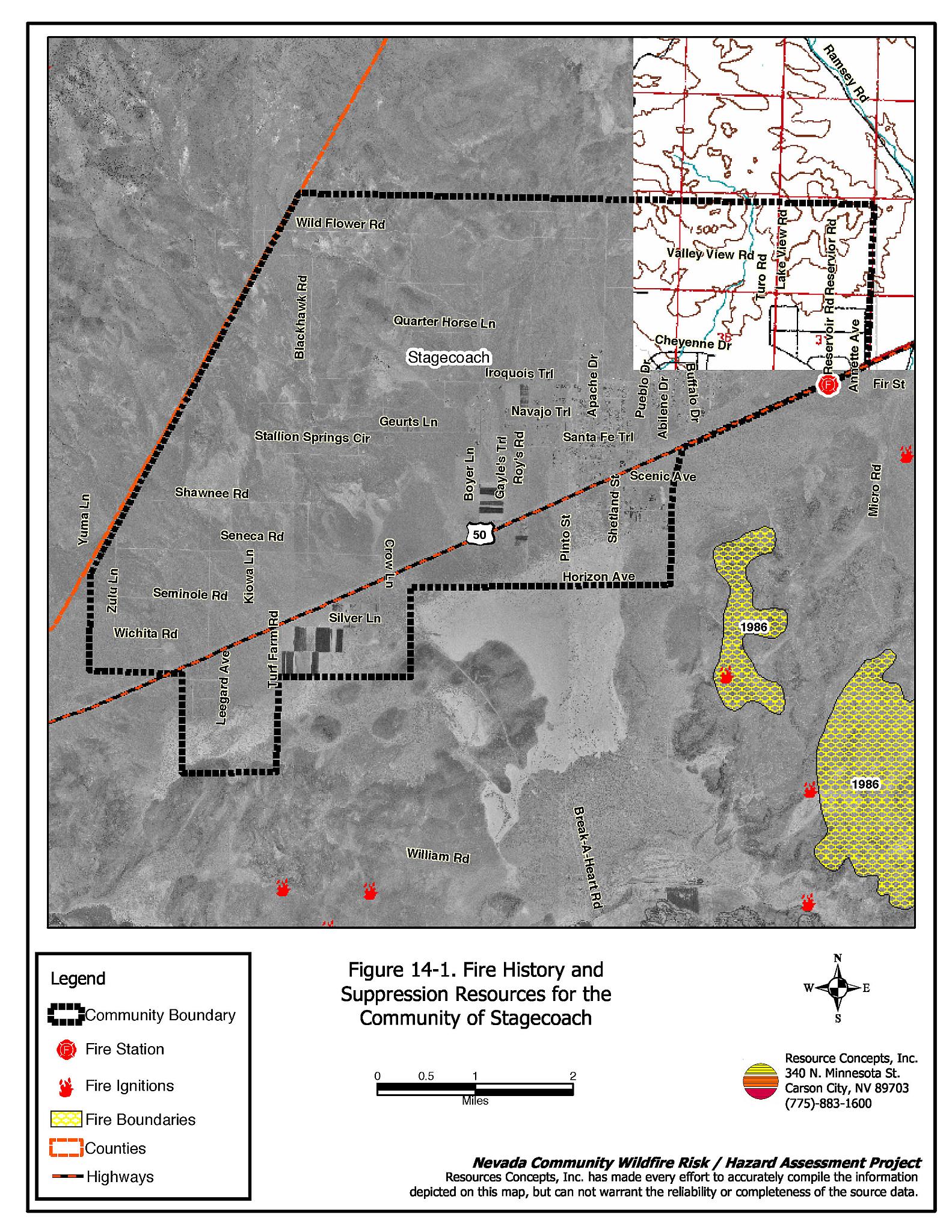
Stagecoach is located in Lyon County in Stagecoach Valley. The community is bordered to the north by the Flowery Range, to the east by Silver Springs, to the south by the Carson River, and the west by Dayton Valley (see Figure 14-1). Approximately 770 residences were evaluated during the assessment. The risk/hazard assessment resulted in classifying Stagecoach in the Low Hazard category (36 points). The low community hazard score is attributed primarily to adequate defensible space and fire-resistant home construction materials. The community wildfire hazard score sheet is provided at the end of this section. The specific findings for each of the wildland fire assessment parameters are reported below.
14.1.1 Community Design
The Stagecoach community is primarily characterized by the intermix urban-interface condition, where homes have been built on larger lots and wildland fuels are often contiguous up to each residence. Lot sizes vary throughout Stagecoach with the majority of lots between one and ten acres in size, and a smaller number of lots greater than ten acres. Structure spacing varies according to lot size.
Roads: The primary access route in Stagecoach is US Highway 50, which is a paved highway greater than 24 feet wide, allowing adequate room for fire suppression equipment to maneuver. Most of the secondary roads in the community are dirt, but provide adequate turn-around space for fire suppression equipment.
Signage: Most streets in Stagecoach have standard metal street signs that are highly visible and easy to read. Residential addresses are easily visible on a majority of homes in Stagecoach. The clear and visible signage throughout the community will assist fire suppression personnel in locating residences during poor visibility conditions that may exist during a wildland fire.
Utilities: The utilities that serve Stagecoach are mostly above ground power lines and above ground propane tanks. In general, utility right-of-ways have been adequately maintained and pose only a low ignition risk to the community.
14.1.2 Construction Materials
A majority of the homes observed in the interface area were built with fire resistant siding materials. Nearly all homes had fire resistant roof materials such as composition shingles, metal, or tile roofing. About one-quarter of the homes observed had unenclosed balconies, porches, decks or other architectural features that can create drafty areas where sparks and embers can be trapped, smolder, and ignite, rapidly spreading fire to the home.
14.1.3 Defensible Space
The vast majority of the homes had landscaping that would meet the defensible space landscape requirement to protect the home from damage or minimize loss during a wildfire.
14.1.4 Suppression Capabilities
Wildfire Protection Resources
The location of the fire station in Stagecoach is shown in Figure 14-1. Wildfire protection is provided by the Central Lyon County Fire Protection District. Refer to Section 4.2 for more information on equipment and resources available.
Water Sources and Infrastructure
Water availability for fire suppression in Stagecoach includes:
- Four community wells;
- 500 gpm hydrants within 500 feet of structures; and
- Four water storage tanks: one 290,000 gallons; one 250,000 gallons; one 100,000 gallons, and one 130,000 gallons.
The community water system operates on gravity and electric pumps. In case of power outage there is a diesel generator for back up.
14.1.5 Factors Affecting Fire Behavior
Stagecoach lies on an alluvial fan south of the Virginia Range foothills. The terrain is generally flat with slopes less than five percent. The dominant aspects in the community are west, south, and southwest. The predominant wind directions are from the west and southwest.
The vegetation in the interface areas around Stagecoach was characterized as salt desert shrub. The shrub layer was dominated by greasewood and Nevada dalea. The ground fuels consisted of Indian ricegrass, cheatgrass, and Russian thistle. The shrubs were widely spaced and less than two feet tall. The fuel load was estimated at less than one-half ton per acre and was considered a low fuel hazard.
14.1.6 Fire Behavior Worst-case Scenario
The worst-case fire behavior scenario would likely occur on a high hazard day, during the summer months of a normal to above normal precipitation year with high cheatgrass production. A lightning-caused fire ignition northwest or southwest of the community in conjunction with erratic 20 to 30 mile per hour winds, often associated with thunderstorms in the area, could cause a fire to spread into the community. Flame lengths of a wind-driven fire in this fuel type could reach four to six feet in length spreading fire at an estimated rate of 1,320 to 1,980 feet per hour.
14.1.7 Ignition Risk Assessment
Stagecoach has a low potential for fire ignitions. The low fuel hazard in the area as well as the location of the dry lakebed south of town, reduce the likelihood of the worst-case scenario occurring.
14.2 Risk and Hazard Reduction Recommendations, Roles, and Responsibilities
The responsibility to keep a community fire safe falls not only on the local fire protection district but also on the residents of the community, businesses, and local governments. The recommendations for Stagecoach focus primarily on additional efforts that can be taken by community members and public agencies to increase wildfire safety through reduction of hazardous fuels. Other recommendations pertain to community coordination and public education efforts that could be undertaken to enhance fire safety in Stagecoach. The recommendations are detailed below and summarized in Table 14-1.
14.2.1 Defensible Space Treatments
The density and type of fuel around a home affects the potential fire exposure levels to the home. The goals of defensible space are to reduce the chances of a wildfire spreading onto adjacent property and igniting homes, and to reduce the risk of property loss from wildfire. General guidelines for creating defensible space around residences and structures in the community are given below and are described in detail in Appendix E.
Property Owner Responsibilities
- Remove, reduce, and replace vegetation to create defensible space around homes according to the guidelines in Appendix E. This area should be kept:
- Lean: There are only small amounts of flammable vegetation
- Clean: There is no accumulation of dead vegetation or other flammable debris
- Green: Existing plants are healthy and green during the fire season.
- Immediately dispose of cleared vegetation when implementing defensible space treatments. This material dries quickly and poses a fire hazard if left on site.
- Maintain defensible space annually or as needed to keep the space lean, clean, and green.
- Store firewood a minimum distance of 30 feet from structures.
- Mow or remove brush growing against wood fences in the community.
- Maintain areas under wood decks and porches free of weeds and other flammable debris. Install screens around unenclosed overhangs where possible.
- Clear all vegetation and combustible materials around propane tanks for a minimum distance of ten feet.
14.2.2 Fuel Reduction Treatments
The following recommendations should be implemented to aid fire suppression activities within the wildland-urban interface.
Central Lyon County Fire Protection District Responsibilities
- Remove or mow vegetation within ten feet of all fire hydrants to improve visibility and access for firefighters.
14.2.3 Community Coordination
Coordination among local, state, and federal fire suppression agencies is important in the day-to-day fire prevention activities and becomes critical in the event of a wildland fire. During a fire event, firefighters from other communities and states may be dispatched to protect areas they have never been before. This is particularly true in areas that have limited fire suppression resources and will most likely depend on outside assistance in the event of a catastrophic wildland fire. The following are recommendations should be implemented in Stagecoach to promote interagency and community coordination.
Property Owner Responsibilities
- Form a local chapter of the Nevada Fire Safe Council. The Nevada Fire Safe Council facilitates solutions to reduce the loss of lives and property from the threat of wildfire in Nevada’s communities. Through the establishment of a local chapter, local communities will become part of a large network for sharing information and receive notifications of programs and funding opportunities for fire mitigation projects such as those listed in this report. The Nevada Fire Safe Council will accept and manage grants and contracts on the chapter’s behalf through its non-profit status. The Nevada Fire Safe Council will provide assistance and support to communities to complete fire safe plans, set priorities, educate and train community members, and promote success stories of its members. To form a local chapter, or for more information contact the:
Nevada Fire Safe Council
1187 Charles Drive
Reno, Nevada 89509
(775) 322-2413
www.nvfsc.org - Assure that residential addresses are visible from the road. Address characters should be at least four inches high, reflective, and composed of non-flammable material. Improving visibility of addresses will make it easier for those unfamiliar with the area to navigate under smoky conditions in the event of a wildland fire.
14.2.4 Public Education
Increased public education on fire safety is critical in communities that have rapidly growing populations, especially when many of the areas being developed are larger lots intermixed with wildland fuels. People moving into the area may be unfamiliar with fire-prone environments.
Central Lyon County Fire Protection District Responsibilities
- Distribute copies of the publication Living with Fire to all property owners. This publication is free of charge. Copies can be requested from the University of Nevada Cooperative Extension.
- Enforce or develop county laws, regulations, and ordinances that support implementation and maintenance of defensible space and address fuel reduction responsibilities for absentee homeowners and vacant lots.
- Contact the University of Nevada Cooperative Extension and the BLM Carson City Field Office for assistance with public education.
14.3 Summary of Recommendations
| Responsible Party | Recommended Treatment | Recommendation Description |
|---|---|---|
| Property Owners | Defensible Space Treatments | Remove, reduce, and replace vegetation around homes according to the guidelines in Appendix E. Maintain defensible space as needed to keep the space lean, clean, and green. |
| Community Coordination | Form a local chapter of the Nevada Fire Safe Council. Improve address visibility. |
|
| Central Lyon County Fire Protection District | Fuel Reduction Treatments | Remove or mow vegetation within ten feet of all fire hydrants to improve visibility and access to fire suppression personnel. |
| Public Education | Distribute copies of the publication Living with Fire to all property owners. Enforce or develop county laws and ordinances for defensible space and fuel reduction responsibilities for absentee owners and vacant lots. Contact Nevada Cooperative Extension and the BLM for assistance with public education. |
Figure 14-1Fire History and Suppression Resources for the Community of Stagecoach |
 |
Stagecoach Wildfire Hazard Rating Summary |
 |