![]()
![]()
16.0 Weed Heights
16.1 Hazard and Risk Assessment
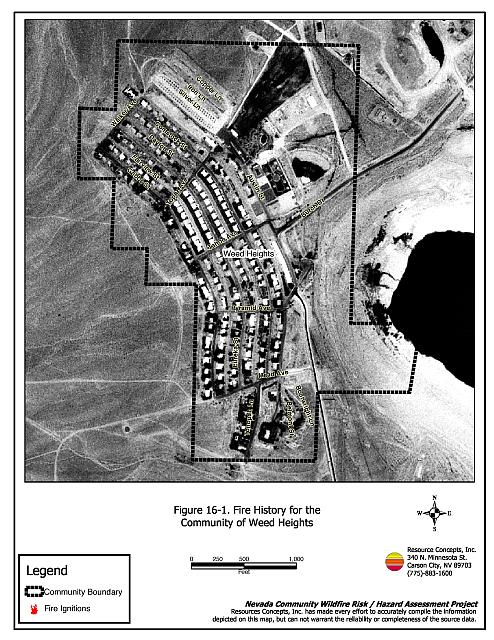
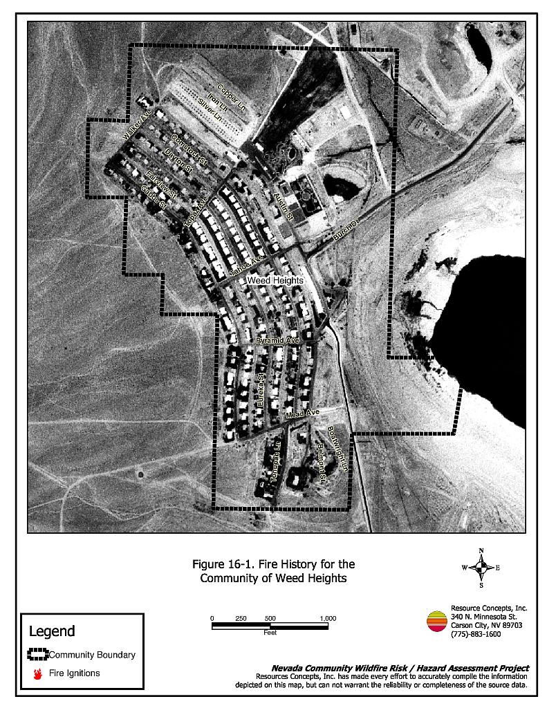
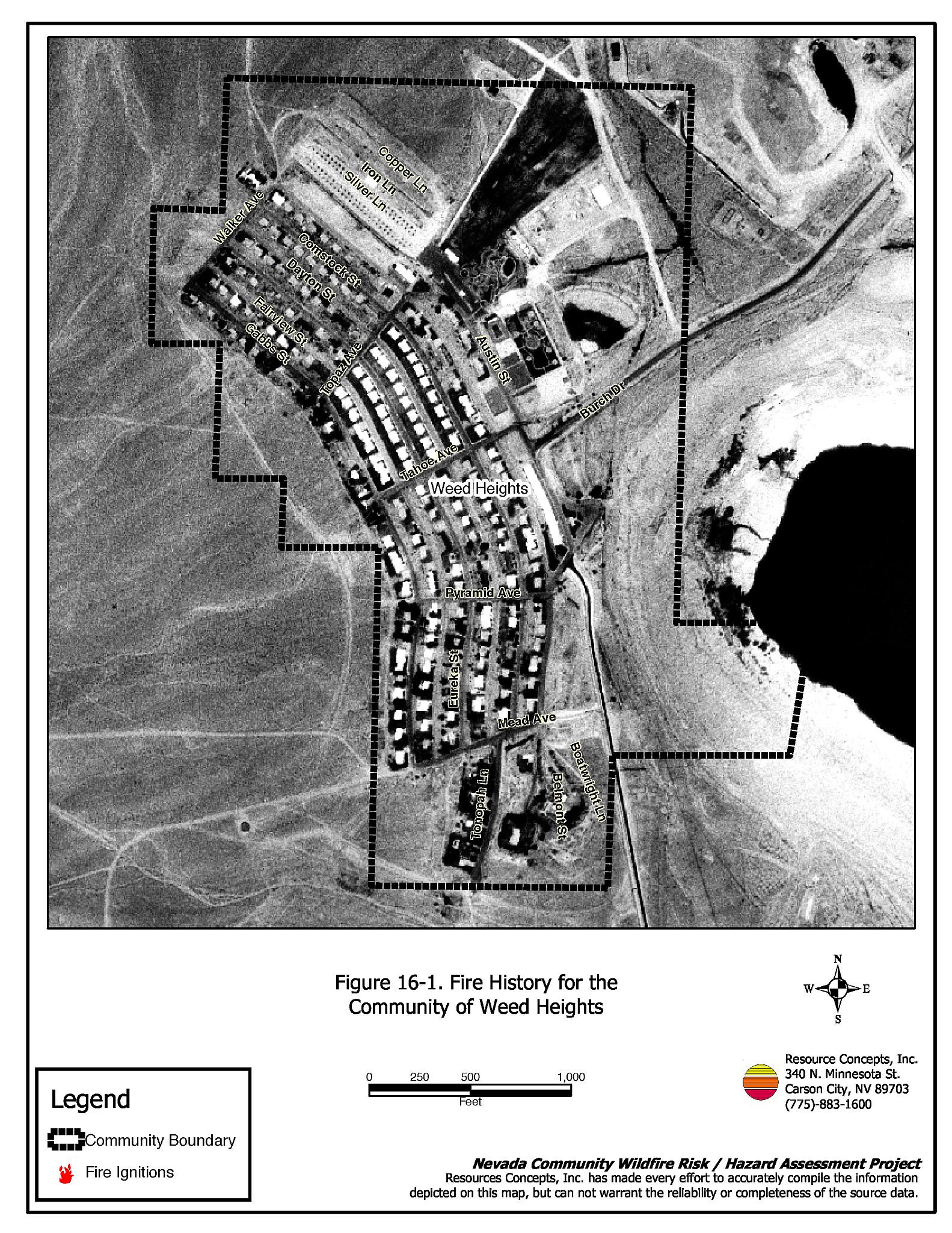
Weed Heights is a small community located east of Yerington in Mason Valley. The community is bordered to the west and south by the Singatse Range, and to the north and east by Anaconda Mine tailings (see Figure 16-1). Approximately 27 residences were evaluated during the risk/hazard assessment. The assessment resulted in classifying Weed Heights in the Moderate Hazard category (42 points). This score is attributed primarily to the close proximity between homes and difficulty in reading street signs and addresses. The community wildfire hazard score sheet is provided at the end of this section. The specific findings for each of the wildland fire assessment parameters are reported below.
16.1.1 Community Design
The urban interface in Weed Heights can be described as classic interface. There is a clear line of demarcation between the wildland fuels and the residences. Lot sizes are primarily less than one acre.
Roads: The primary access route for Weed Heights residences is Burch Drive. This road is between 20 and 24 feet wide and allows adequate room for fire suppression equipment to maneuver. Secondary roads in the community have adequate turn-around space at road terminus points for fire suppression equipment. Road grades exceed five percent in some areas of the community.
Signage: The majority of residential streets in Weed Heights have street signs that are starting to fade and are difficult to read. About three-quarters of residential addresses are easily visible. Clear and visible residential addresses and street signs are important to aid fire-fighting personnel in locating homes during low visibility conditions that may be present during a wildland fire.
Utilities: The utilities that serve Weed Heights are primarily above ground power lines and propane tanks. In general utility right-of-ways have been adequately maintained and pose only a low ignition risk to the community.
16.1.2 Construction Materials
All of the homes observed in the interface area were built with fire resistant siding and roofing materials. Very few of the homes observed had unenclosed balconies, porches, decks or other architectural features that can create drafty areas where sparks and embers can be trapped, smolder, and ignite, rapidly spreading fire to the home.
16.1.3 Defensible Space
A majority of the homes had landscaping that would meet the defensible space landscape requirement to protect the home from damage or minimize loss during a wildfire.
16.1.4 Suppression Capabilities
Wildfire Protection Resources
Wildfire protection is provided by the Mason Valley Fire Protection District. There is no established volunteer fire department in Weed Heights. Refer to Section 4.2 for more information on equipment and resources available.
Water Sources and Infrastructure
Water availability for fire suppression in Weed Heights includes:
- Community wells;
- 500 gpm hydrants within 1,000 feet of structures;
- Water storage tanks; and the
- Anaconda pit water that can be used as a helicopter dip site.
The community water system operates on gravity and electric pumps, with a backup diesel generator.
16.1.5 Factors Affecting Fire Behavior
Fuels along the Weed Heights interface were primarily salt desert shrub vegetation. Shrub species in the area included greasewood, spiny hopsage, Mormon tea, and shadscale. Ground fuels were composed of cheatgrass, Indian ricegrass, Russian thistle and bottlebrush squirreltail. Spacing between plants was generally between five and 20 feet with shrub heights of one to two feet. The fuel load was estimated at less than one ton per acre. Fuels around Weed Heights were considered to be a low hazard.
Weed Heights is surrounded by foothills and mountains to the west, and slopes within the community less than ten percent. The general aspect is to the east, and the predominant wind directions are from the west and southwest.
16.1.6 Fire Behavior Worst-case Scenario
The worst-case fire behavior scenario would likely occur on a high hazard day during the summer months, in an above-normal precipitation year that results in high cheatgrass production. A fire ignition west of the community could spread toward the community if driven by typical afternoon downslope west winds. Typical flames lengths in the fuel type around Weed Heights would be two to four feet with fire spread rates of 660 to 1,980 feet per hour. The light fuel load and associated fire behavior would facilitate fire suppression.
16.1.7 Ignition Risk Assessment
Weed Heights has a low risk of fire ignition. Mine tailings act as firebreaks on the east and north sides of the community.
16.2 Risk and Hazard Reduction Recommendations, Roles, and Responsibilities
The responsibility to keep a community fire safe falls not only on the local fire protection district but also on the residents of the community, businesses, and local governments. The recommendations for Weed Heights focus primarily on additional efforts that can be taken by community members and public agencies to increase wildfire safety through reduction of hazardous fuels. Other recommendations pertain to community coordination and public education efforts that could be undertaken to enhance fire safety in Weed Heights. The recommendations are detailed below and summarized in Table 16-1.
16.2.1 Defensible Space Treatments
The density and type of fuel around a home affects the potential fire exposure levels to the home. The goals of defensible space are to reduce the chances of a wildfire spreading onto adjacent property and igniting homes, and to reduce the risk of property loss from wildfire. General guidelines for creating defensible space around residences and structures in the community are given below and are described in detail in Appendix E.
Property Owner Responsibilities
- Remove, reduce, and replace vegetation to create defensible space around homes according to the guidelines in Appendix E. This area should be kept:
- Lean: There are only small amounts of flammable vegetation
- Clean: There is no accumulation of dead vegetation or other flammable debris
- Green: Existing plants are healthy and green during the fire season.
- Immediately dispose of cleared vegetation when implementing defensible space treatments. This material dries quickly and poses a fire hazard if left on site.
- Remove debris and flammable materials from within the defensible space area.
- Maintain defensible space as needed to keep the space lean, clean, and green.
- Mow or remove brush growing against wood fences in the community.
- Clear all vegetation and combustible materials around propane tanks for a minimum distance of ten feet.
- Abandoned trailers and structures should be removed or boarded up to prevent sparks entering and igniting the structure.
16.2.2 Community Coordination
Coordination among local, state, and federal fire suppression agencies is important in the day-to-day fire prevention activities and becomes critical in the event of a wildland fire. During a fire event, firefighters from other communities and states may be dispatched to protect areas they have never been before. This is particularly true in areas that have limited fire suppression resources and will most likely depend on outside assistance in the event of a catastrophic wildland fire. The following are recommendations should be implemented in Weed Heights to promote interagency and community coordination.
Property Owner Responsibilities
- Assure that residential addresses are visible from the road. Address characters should be at least four inches high, fire resistant, and composed of non-flammable material. Improving visibility of addresses will make it easier for those unfamiliar with the area to navigate under smoky conditions in the event of a wildland fire .
Lyon County Responsibilities
- Improve street sign visibility.
16.2.3 Public Education
Increased public education on fire safety is critical in communities that have rapidly growing populations, especially when many of the areas being developed are larger lots intermixed with wildland fuels. People moving into the area may be unfamiliar with fire-prone environments.
Mason Valley Fire Protection District Responsibilities
- Distribute copies of the publication Living with Fire to all property owners. This publication is free of charge. Copies can be requested from the University of Nevada Cooperative Extension.
- Enforce or develop county laws, regulations, and ordinances that support implementation and maintenance of defensible space and address fuel reduction responsibilities for absentee homeowners and vacant lots.
16.3 Summary of Recommendations
| Responsible Party | Recommended Treatment | Recommendation Description |
|---|---|---|
| Property Owners | Defensible Space Treatments | Remove, reduce, and replace vegetation around homes according to the guidelines in Appendix E. Maintain defensible space as needed to keep the space lean, clean, and green. |
| Access | Improve address visibility. | |
| Lyon County | Community Coordination | Improve street sign visibility. |
| Mason Valley Fire Protection District | Public Education | Distribute copies of the publication Living with Fire to all property owners. Enforce or develop county laws and ordinances for defensible space and fuel reduction that include responsibilities for absentee owners and vacant lots. |
Figure 16-1Fire History for the Community of Weed Heights |
 |
Weed Heights Wildfire Hazard Rating Summary |
 |