![]()
![]()
17.0 Yerington
17.1 Hazard and Risk Assessment
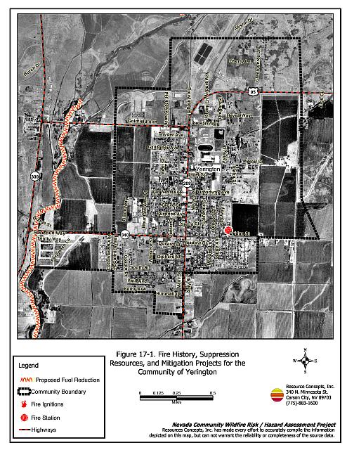
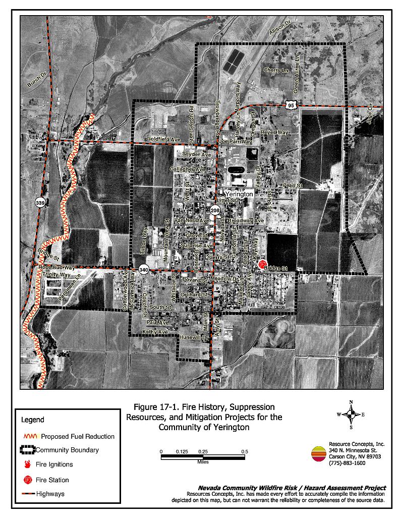
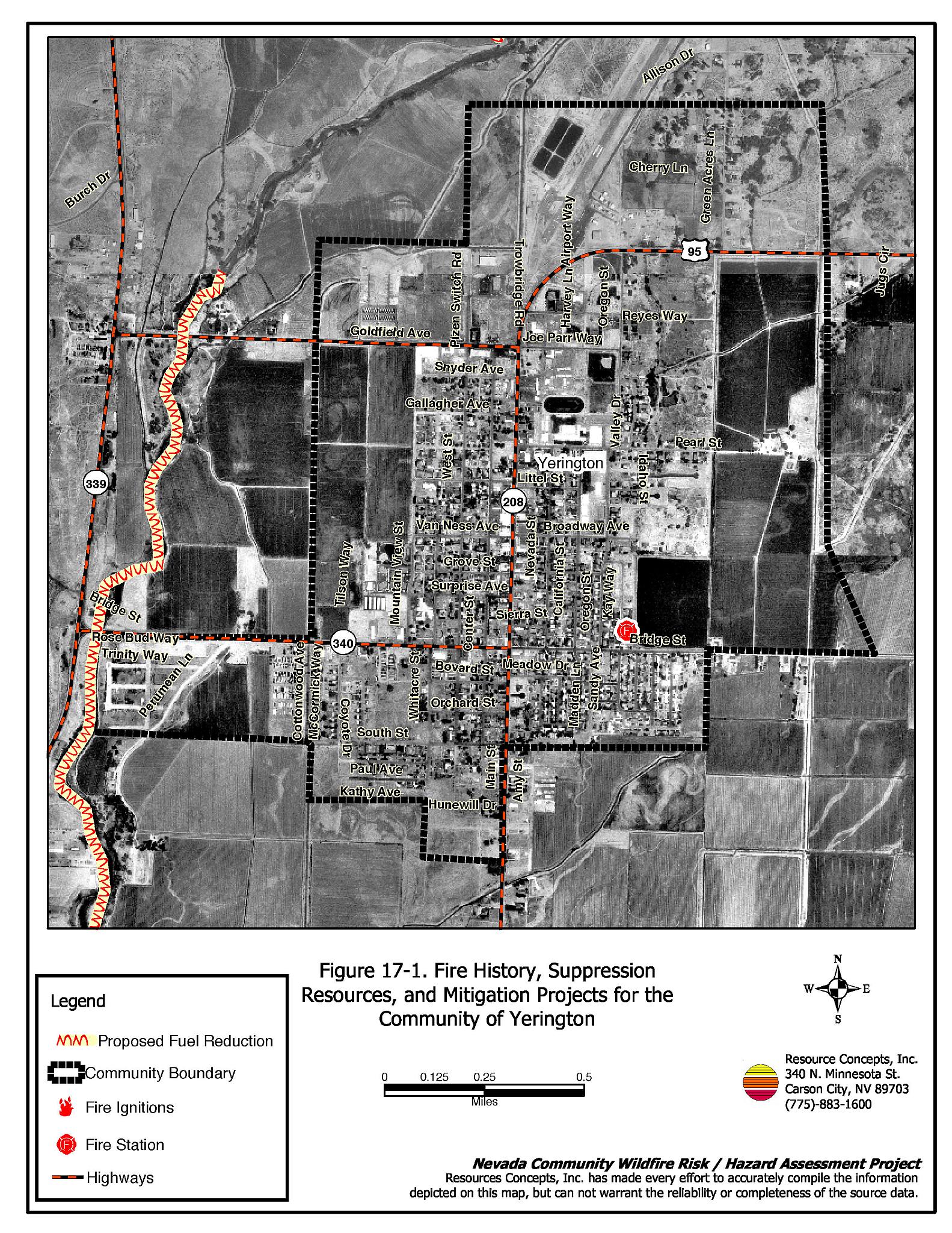
The incorporated town of Yerington is the county seat of Lyon County. The town is located in the center of Mason Valley in central Lyon County (see Figure 17-1). The town is bordered to the west and north by the Walker River, and to the east and south by agricultural lands. The estimated population in Yerington as of 2003 was 2,902 (Nevada State Demographers, 2003). Approximately 96 residences were evaluated during the risk/hazard assessment. The assessment resulted in classifying Yerington in the Low Hazard category (28 points). The low community hazard rating is attributed primarily to low fuel loads, adequate defensible space, and presence of a fire department in town. The community wildfire hazard score sheet is provided at the end of this section. The specific findings for each of the wildland fire assessment parameters are reported below.
17.1.1 Community Design
Yerington can be described as a classic interface urban community that lies within the larger agricultural community of Mason Valley. The average lot size in Yerington is less than one acre with a smaller number of parcels between one and ten acres. Structure spacing varies according to lot size.
Roads: The primary access routes in Yerington are US Alternate Highway 95, and State Routes 339, 340, and 208, which are paved highways greater than 24 feet wide that allow adequate room for fire suppression equipment to maneuver. Primary and secondary roads have grades less than five percent, and have adequate turn-around space at road terminus points for fire suppression equipment.
Signage: The majority of residential streets in Yerington have standard metal street signs that are highly visible and easily read. Residential addresses are easily visible on about three-fourths of homes in Yerington. The clear and visible signage throughout Yerington will assist fire suppression personnel in locating residences during poor visibility conditions that may exist during a wildland or structure fire.
Utilities: The utilities that serve Yerington are a combination of above ground and below ground power lines with occasional areas served by propane. In general, utilities have adequately maintained right-of-ways and pose only a low ignition risk to the community.
17.1.2 Construction Materials
A majority of the homes observed in the interface area were built with fire resistant siding materials. A great majority of the homes had fire resistant roof materials such as composition shingles, metal, or tile roofing. Very few of the homes observed had unenclosed balconies, porches, decks, or other architectural features that can create drafty areas where sparks and embers can be trapped, smolder, and ignite, rapidly spreading fire to the home.
17.1.3 Defensible Space
The vast majority of the homes had landscaping that would meet the defensible space landscape requirement to protect the home from damage or minimize loss during a wildfire.
17.1.4 Suppression Capabilities
Wildfire Protection Resources
The Mason Valley Fire Protection District provides wildfire protection to Yerington. The closest fire station is in Yerington. Refer to Section 4.2 for more information on equipment and resources available.
Water Sources and Infrastructure
Water availability for fire suppression in Yerington includes:
- Community wells;
- 500 gpm hydrants with distances to structures from 500 feet to 1,000 feet depending upon location;
- Water storage tanks up to one million gallons; and
- Water drafting sources including the cooling ponds at the power station, the Walker River, and agricultural water storage tanks that can be used with landowner permission.
The community water system operates on gravity and electric pumps, with backup diesel generators.
17.1.5 Factors Affecting Fire Behavior
The urban interface around Yerington was almost entirely agricultural land with little to no native fuels. Weeds including Russian thistle and kochia were growing along irrigation ditches and drains, however these are usually burned annually. When irrigated, agricultural lands were considered a low fuel hazard.
Fuels along the Walker River corridor included a tree canopy of willow, cottonwood, tamarisk, and Russian olive that ranged between 15 and 60 feet in height. The shrub layer was approximately five to six feet in height dominated by black greasewood and four-wing saltbush. The ground fuels included riparian grasses and sedges and upland species of saltgrass, Indian ricegrass, and bottlebrush squirreltail. Fuels were dense within the river corridor forming a closed canopy condition in some areas. Fuel loads were estimated to range between 20 and 30 tons per acre, and were considered a heavy fuel type and moderate to high fuel hazard. The fuel hazard for Yerington is depicted on Figure 17-2. A representative photograph of the riparian corridor is shown in Figure 9-3 (Mason Valley).
The terrain around Yerington is very flat with slopes less than two percent. The predominant wind directions are from the west and southwest.
17.1.6 Fire Behavior Worst-case Scenario
There have been no wildfires ever recorded within the Yerington town limits. It is highly unlikely that a wildland-urban interface fire would ever occur in the central portion of the community. A small portion of the community along the Walker River near Trinity Way and Perumean Lane could be affected should an ignition occur in the afternoon and spread quickly into a high-intensity fire. Rapid spread rates through the dense fuels along the River Corridor and limited access could limit fire suppression capabilities.
17.1.7 Ignition Risk Assessment
Yerington is viewed as having a low ignition risk.
17.2 Risk and Hazard Reduction Recommendations, Roles, and Responsibilities
The responsibility to keep a community fire safe falls not only on the local fire protection district but also on the residents of the community, businesses, and local governments. The recommendations for Yerington focus primarily on additional efforts that can be taken by community members and public agencies to increase wildfire safety through reduction of hazardous fuels. Other recommendations pertain to community coordination and public education efforts that could be undertaken to enhance fire safety in Yerington. The recommendations are detailed below and summarized in Table 17-1.
17.2.1 Fuel Reduction Treatments
The following fuel reduction treatment is a continuation of the treatment recommended for the Mason Valley Community. The treatment should be implemented to reduce potential fire hazard to homes located near the Walker River, including homes in Yerington. Several fires occur within the River corridor every year. By implementing the recommended fuels reduction treatment there will be less chance for ignitions to spread and threaten homes and wildlife habitat along the corridor.
Property Owner and County Responsibilities
- Yerington property owners should cooperate with Mason Valley property owners to implement this fuel reduction project. Reduce the fuels along reaches of the Walker River corridor that do not have irrigated agricultural land on both sides of the river. Fuels should be reduced to approximately one ton per acre, prioritizing removal of dead wood and debris. Primary tree and brush species to target for thinning and removal include tamarisk, Russian olive, dead willow and cottonwood branches, greasewood, and four-wing saltbush. Live willow and cottonwood trees should not be removed but may be pruned to remove dead branches within the canopy. The treatment should be installed between 100 and 300 feet wide on both sides of the river where indicated on Figure 17-1. The approximate lengths of all the treatment areas combined is 14.5 miles for a total treatment acreage between 175 and 525 acres, however the treatment area that would directly affect Yerington is less than one mile long.
- Landowners should coordinate with Nevada Department of Wildlife biologists and other interested parties to identify any special treatment specifications relative to wildlife habitat concerns.
17.2.2 Community Coordination
Coordination among local, state, and federal fire suppression agencies is important in the day-to-day fire prevention activities and becomes critical in the event of a wildland fire. During a fire event, firefighters from other communities and states may be dispatched to protect areas they have never been before. This is particularly true in areas that have limited fire suppression resources and will most likely depend on outside assistance in the event of a catastrophic wildland fire. The following are recommendations should be implemented in Yerington to promote interagency and community coordination.
Property Owner Responsibilities
- Join with Mason Valley residents to form a local chapter of the Nevada Fire Safe Council. The Nevada Fire Safe Council facilitates solutions to reduce the loss of lives and property from the threat of wildfire in Nevada’s communities. Through the establishment of a local chapter, local communities will become part of a large network for sharing information and receive notifications of programs and funding opportunities for fire mitigation projects such as those listed in this report. The Nevada Fire Safe Council will accept and manage grants and contracts on the chapter’s behalf through its non-profit status. The Nevada Fire Safe Council will provide assistance and support to communities to complete fire safe plans, set priorities, educate and train community members, and promote success stories of its members. To form a local chapter, or for more information contact the:
Nevada Fire Safe Council
1187 Charles Drive
Reno, Nevada 89509
(775) 322-2413
www.nvfsc.org
Nevada Department of Wildlife
- Develop guidelines and specifications for implementing fuel reduction treatments in the river corridor to address wildlife habitat concerns such as timing of implementation to minimize impacts during nesting, and pesticide application procedures for tamarisk removal.
17.3 Summary of Recommendations
| Responsible Party | Recommended Treatment | Recommendation Description |
|---|---|---|
| Property Owners | Fuel Reduction Treatments | Reduce fuel loads along the Walker River corridor for a distance of approximately one mile and a width of 100 to 300 feet on both sides of the River, in conjunction with Mason Valley landowners. |
| Community Coordination | Form a local chapter of the Nevada Fire Safe Council with Mason Valley homeowners. | |
| Lyon County | Fuel Reduction Treatments | Work with landowners to coordinate fuel reduction activities along the Walker River. |
| Nevada Department of Wildlife | Community Coordination | Develop guidelines and work with landowners to implement fuel reduction treatments along the Walker River corridor. |
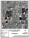
Figure 17-1Fire History, Suppression Resources, and Mitigation Projects for the Community of Yerington |
 |
Yerington Wildfire Hazard Rating Summary |
 |