![]()
![]()
7.0 Clear Creek
7.1 Risk and Hazard Assessment
Clear Creek is located in the southwestern portion of Carson City, three miles west of US Highway 395, and south of US Highway 50 on Clear Creek Road. The Clear Creek community is situated in a canyon on a south- facing slope in the Carson Range. There are about 23 full-time residences in the Clear Creek area. The risk/hazard assessment resulted in classifying Clear Creek in the High Hazard category (77 points). A summary of the values that affect this hazard rating is included in Table 7-2. The primary wildfire hazards for Clear Creek were limited road access into and out of the community, lack of defensible space around many structures, and the potential severe fire behavior due to topography and fuel loading.
7.1.1 Community Design
The Clear Creek community was characterized by intermix wildland-urban interface conditions. Structures are scattered throughout the wildland area with no clear line of demarcation between wildland fuels and the buildings in the community. In Clear Creek, most homes are situated on lots between five and ten acres in size. These scattered structures are widely spaced and interspersed with wildland fuels. The Clear Creek Youth Center is located at the west end of the community.
- Access: Clear Creek has one paved road in and out of the community. This road is listed as State Route 705 for the first mile west of U.S. Highway 395 and as Old Clear Creek Road further west. Old Clear Creek Road is between 20 and 24 feet and allows adequate room for fire suppression equipment to maneuver. The road gradient on primary and secondary roads is steeper than five percent. Steep roads and limited access to the community could limit fire suppression and evacuation activities during a wildland fire.
- Signage: All streets had visible street signs, however approximately one-fourth of the homes had inadequate address visibility. Most homes were easily visible from the three residential roads in the small community. There would be little chance of fire suppression personnel being unable to locate a particular structure that needed protection, except during smoky conditions often present during wildland fires.
- Utilities: Underground electrical and above ground propane tanks were the primary utilities serving Clear Creek. The underground electrical service reduces any potential ignition risk from utilities. Vegetation clearance around propane tanks was generally in need of improvement.
7.1.2 Construction Materials
All of the structures in the community were built with heat or flame resistant siding materials. Almost all of the structures had fire resistant roofing materials such as composition roofing, metal, or tile. Five of the homes observed had architectural features such as an unenclosed balcony, porch, or deck that create drafty areas where embers and firebrands can be trapped, smolder, and ignite, rapidly spreading fire to the home.
7.1.3 Defensible Space
Approximately fifty percent of the structures in the Clear Creek Community had adequate defensible space of 100 feet or greater in areas surrounded by shrubs, and 30 feet in areas without brushy fuels.
7.1.4 Suppression Capabilities
Wildfire Protection Resources
The Carson City Fire Department and the NDF Sierra Forest Fire Protection District provide wildland and structure fire protection to the Clear Creek Community. See Tables 4-2 and 4-3 for additional information on fire protection resources available for initial attack of wildland fires near Carson City communities.
Water Sources and Infrastructure
Water availability for fire suppression in the Clear Creek community includes a limited drafting source from Clear Creek, one pond, and two residences with water storage facilities. Two underground water tanks support the hydrant system at the Clear Creek Youth Facility. Fire suppression water tenders can refill at a source near the intersection of U.S. Highway 395 and Old Clear Creek Road in the event of a wildfire (ten to twenty minute round trip. (Dynamac, 2003).
Community Preparedness
Clear Creek is included in the Carson City emergency and disaster plans. The residents of the community have formed a chapter of the Nevada Fire Safe Council. There is currently no evacuation plan for residents of the community, nor do the emergency and disaster plans provide information on safe zones within the community. Development plans for the community are reviewed by the Carson City Fire Department.
7.1.5 Factors Affecting Fire Behavior
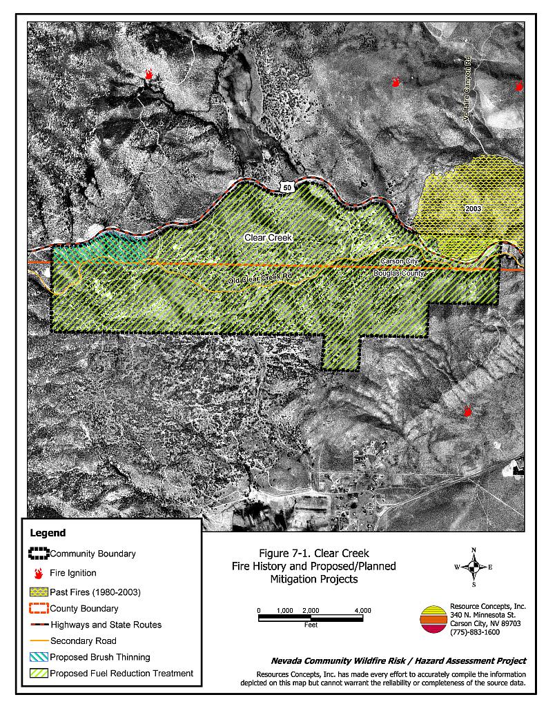
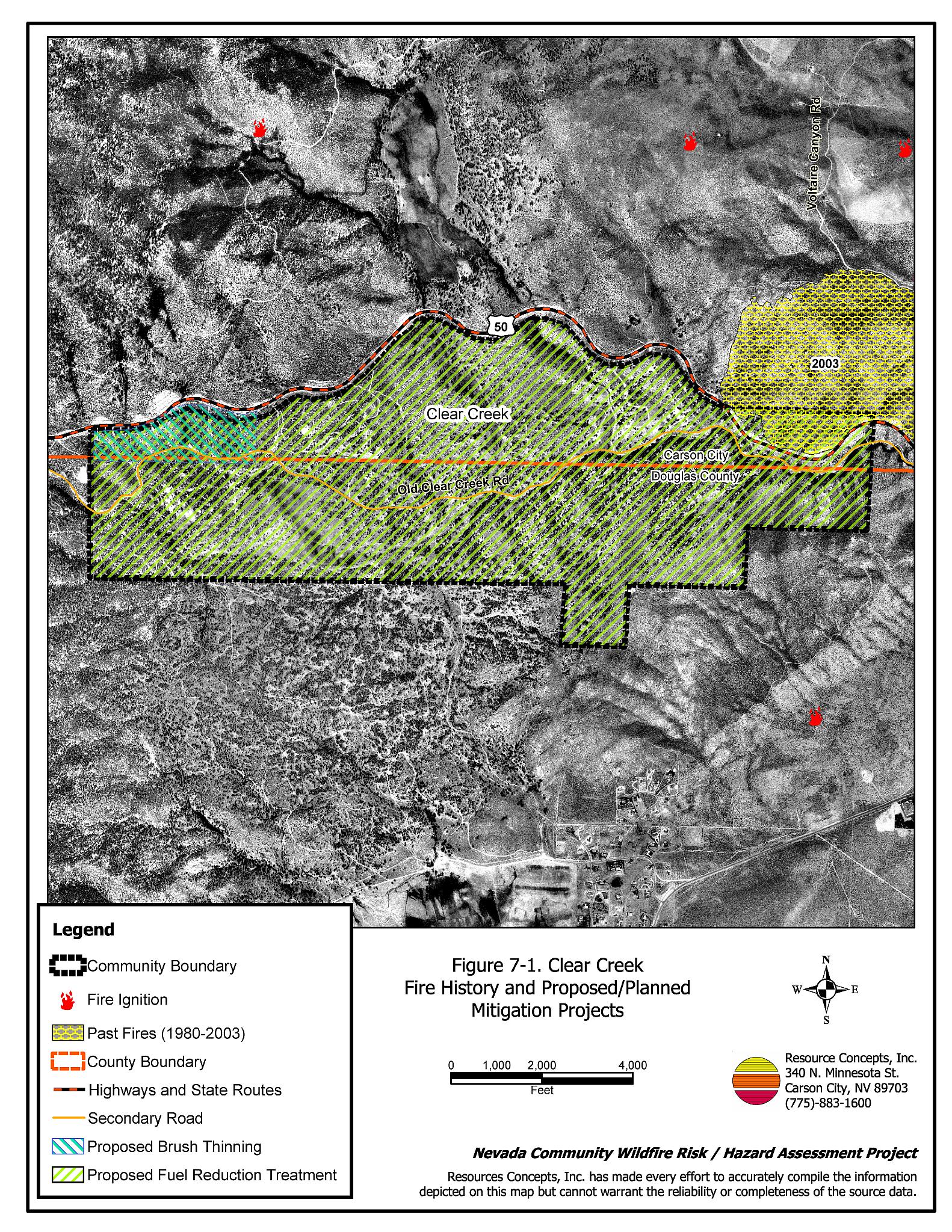
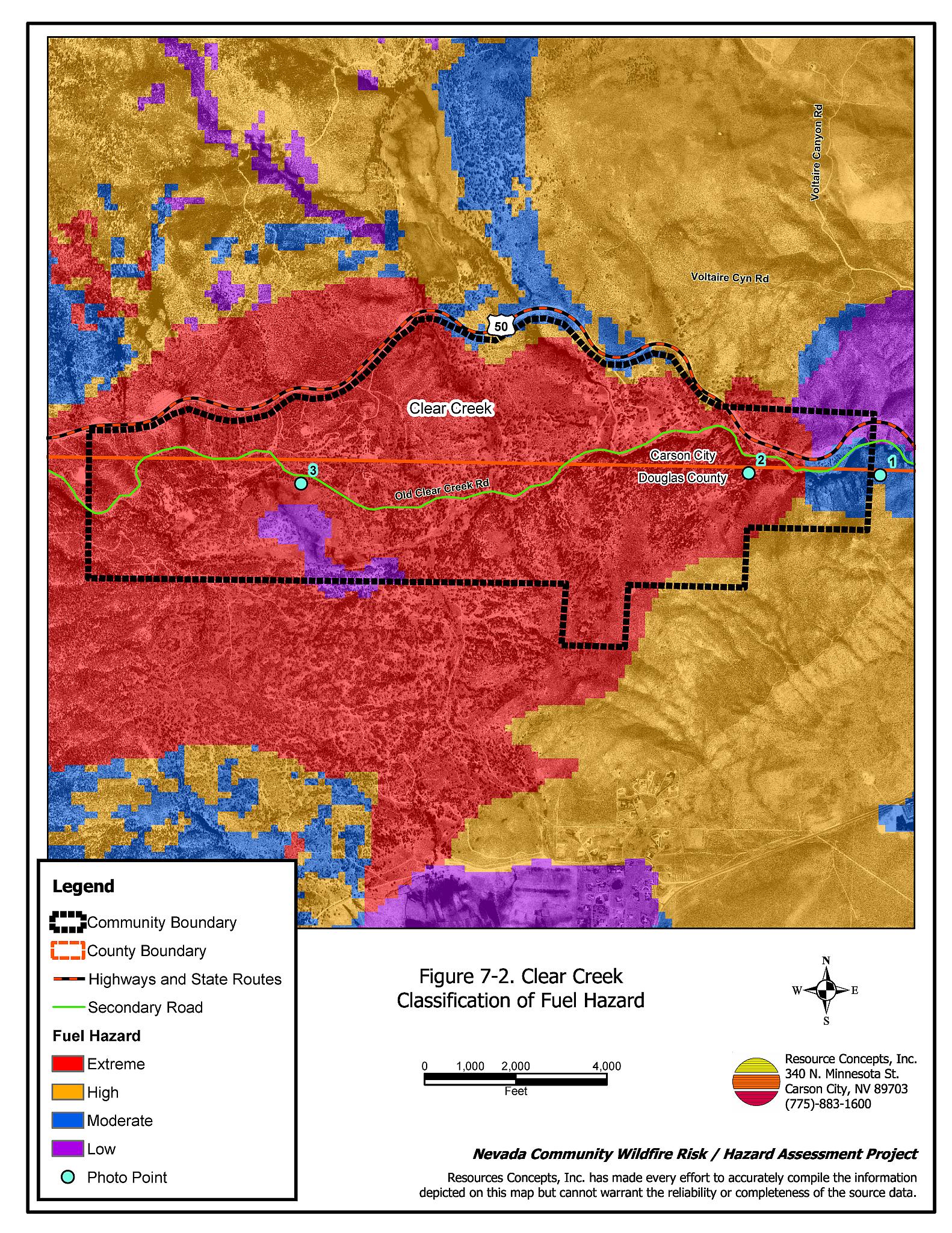
Vegetation, down fuels, and topography contribute to the potential fire hazard around wildland-urban interface communities. Fuel hazards were mapped for Clear Creek as shown in Figure 7-2. Fuel hazard photo points were established to document current fuel hazard conditions around the community and are provided in Figure 7-3.
Clear Creek is situated in an east-west directional canyon with most of the homes located on the south-facing slope, surrounded on three sides by mountains. The prevailing winds are from the west-southwest. Slopes vary from five to greater than forty percent. The fuel density is heavy in the area surrounding structures, estimated at five tons per acre. Fuels consisted primarily of Jeffrey pine with manzanita, big sagebrush, bitterbrush, and snowbrush in the brush layer. Perennial grass, cheatgrass, squaw carpet, and pine needle duff comprise the ground fuels in the area. The brush density varied from moderate to heavy and was rated as an extreme fuel hazard.
7.1.6 Previous Fire Hazard Reduction Projects
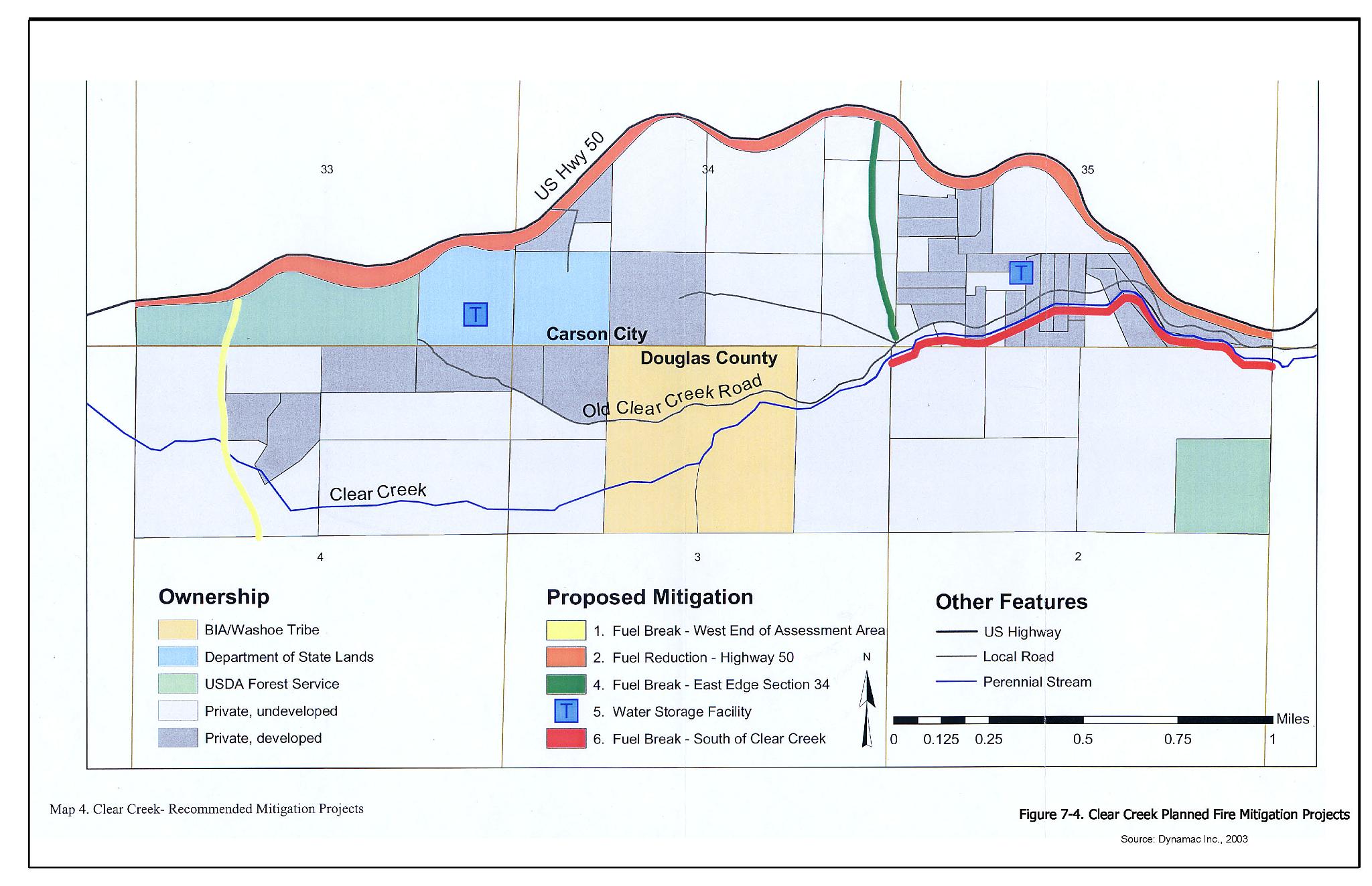
In 2003, the Nevada Fire Safe Council funded a wildfire risk/hazard assessment and hazard mitigation plan for the Clear Creek community. Dynamac, Inc. of Oregon conducted the risk/hazard assessment and proposed defensible space and fuel reduction treatments for the area that are summarized below and shown on Figure 7-4. Projects 2 and 3 have been completed, and Project 1 is scheduled to be completed in 2005. The Clear Creek chapter of the Nevada Fire Safe Council is also planning to complete a north-south fuelbreak in T15N, R19E, Section 34, in 2005 (Arnold pers.comm.).
- Create a shaded fuelbreak 100 to 150 feet wide and 1.2 miles in length on both USFS and private land in T14N, R19E, Section 4 and T15N, R19E, Section 33. Trees should be thinned to a crown spacing of at least twenty feet with trees limbed to fifteen feet from the ground and brush cover reduced to thirty percent or less. The fuelbreak should be seeded with perennial bunch grasses to reduce weed invasions, fire threats, and erosion potential.
- Implement fuel reduction treatments on all areas of continuous fuels larger than two to three acres throughout both the private property in Section 35 and the Schulz private property in T15N, R19E, Section 35. Create shaded fuelbreaks along the west and south edges of the Schulz property.
- Create a firebreak [fuelbreak] between Highway 50 and Old Clear Creek Road 200 to 250 feet wide and 0.5 miles long on T15N, R19E, Sections 34 and 35. Remove all ladder fuels, prune all remaining trees, and increase degree of shrub thinning toward the most eastern fifty feet of the break where no trees or brush should remain.
- Create a fuelbreak 150-feet wide and 1.2 miles long in T14N, R19E, Section 2. The shaded fuelbreak should extend from the east to west across Section 2, running along the slope at the base of the ridge parallel to Clear Creek.
7.1.7 Fire Behavior Worst-Case Scenario
A worst-case wildfire scenario for Clear Creek would likely occur in late afternoon on a high hazard day during a dry lightning storm with numerous ignitions along the Carson Range. Downslope and erratic winds would push a fire, or numerous fires, toward existing structures. The scenario would be worsened if mutual aid resources were delayed due to assignment to an emergency situation elsewhere. If a wildfire were to block Old Clear Creek Road, evacuation and fire suppression would be greatly jeopardized.
7.1.8 Ignition Risk Assessment
Clear Creek has a high ignition risk rating due in part to the large number of fire ignitions that have occurred in the last twenty years along the Eastern Sierra Front. Wildfire and ignitions have been recorded for the areas both north and southwest of Clear Creek (see Figure 3-2).
7.2 Risk and Hazard Reduction Recommendations, Roles, and Responsibilities
The Clear Creek risk and hazard reduction recommendations address the primary concern regarding protection of existing and future development in the wildland-urban interface area. Other recommendations pertain to community coordination and public education efforts that could be undertaken to enhance fire safety in Clear Creek.
7.2.1 Defensible Space Treatments
Defensible space is an essential first line of defense for residential structures. Significantly reducing or removing vegetation within a prescribed distance from structures (a minimum of 30 feet to 200 feet depending upon slope and vegetative fuel type) reduces fire intensity and improves firefighter and homeowner chances for successfully defending a structure against oncoming wildfire. Improving address identification improves firefighters’ ability to locate structures during smoky conditions.
Property Owner Responsibilities
- Remove, reduce, and replace vegetation around homes according to the guidelines in Appendix F. This area should be kept:
- Lean: There are only small amounts of flammable vegetation,
- Clean: There is no accumulation of dead vegetation or other flammable debris, and
- Green: Existing plants are healthy and green during the fire season.
- Maintain this defensible space as needed to keep the space lean, clean, and green.
- Clear all vegetation and combustible materials around propane tanks for a minimum distance of ten feet.
- Store firewood a minimum distance of thirty feet from structures.
- Spark arresting screens should be installed on chimneys.
- Maintain areas under wood decks and porches free of weeds and other flammable debris.
- Pine needles, leaves, and debris should be removed from roofs and rain gutters.
- Prune trees so that branches are at least fifteen feet away from chimneys and/or structures.
- For trees remaining within the defensible space zone, homeowners should limb branches a minimum of five feet from the ground (or up to one-third of the tree height) to reduce ladder fuels. Remove flammable material including shrubs and duff from beneath crowns of retained trees.
- Immediately dispose of cleared vegetation when implementing defensible space treatments. The material dries quickly and poses a fire hazard if left on site.
- Irrigate all trees and large shrubs in close proximity to structures to increase their fire resiliency. This is especially important during drought conditions.
- Consider purchasing a fire suppression product for their homes such as fire blocking gels. These gels/foams can be applied to structures and vegetation to create an added layer of flame resistance in the event of a fire.
- Assure that residential addresses are visible from the road. Address characters should be at least four inches high, reflective, and composed of non-flammable material. Improving visibility of addresses will make it easier for those unfamiliar with the area to navigate an area under smoky conditions in the event of a wildland fire.
Nevada Division of State Lands Responsibilities - Clear Creek Youth Center
- Remove, reduce, and replace vegetation around Youth Center structures according to the guidelines in Appendix F. This area should be kept:
- Lean: There are only small amounts of flammable vegetation,
- Clean: There is no accumulation of dead vegetation or other flammable debris, and
- Green: Existing plants are healthy and green during the fire season.
- Remove or properly board up abandoned or unused structures in the Clear Creek Youth Center to prevent sparks from entering and igniting structures.
7.2.2 Fuel Reduction Treatments:
Fuel reduction treatments are applied on a larger scale than defensible space treatments. Fuel reduction treatments are most effective when implemented on large blocks of land to permanently change the fuel structure to create a condition of lower fuel volume and lower ignition potential.
There are several areas within Clear Creek where reducing vegetation along roads and driveways could reduce the likelihood of wildfire spreading across roads, and improving firefighter safety, and improving evacuation routes in the event of a wildfire. The areas of most concern are along Old Clear Creek Road and residential driveways greater than 200 feet in length.
Property Owners, Nevada Division of State Lands, Nevada Division of Forestry, US Forest Service, Washoe Tribe, and Carson City Fire Department Responsibilities
- Coordinate with each property owner, responsible administrative agency, the Carson City Fire Department, and the Nevada Division of Forestry to implement landscape-wide treatments to reduce tree stands to a basal area of 80 square feet per acre as well as reduce and remove brush ladder fuels from beneath all tree crowns in the proposed 1,690-acre treatment area (see Figure 7-1). The existing Clear Creek chapter of the Nevada Fire Safe Council can facilitate agency coordination and help identify funding opportunities.
- Coordinate with each property owner, Clear Creek chapter of the Nevada Fire Safe Council, responsible administrative agency, the Carson City Fire Department, and the Nevada Division of Forestry to pursue funding for and implement all remaining projects specified in the Dynamac (2003) report and summarized in section 7.1.6 and shown in Figure 7-4. The RCI Project Team recommends that any fuel reduction treatments in the area adjacent to the creek be evaluated on a site-specific basis due to slope, access, and riparian concerns.
- Carry out an ongoing maintenance program for all fuel reduction treatments.
- Reduce fuels within a minimum distance of twenty feet along both sides of private driveways longer than 200 feet. Trees should be thinned to a spacing of thirty feet between crowns and shrubs should be thinned to two times the height of the shrubs. Flammable vegetation should be replaced with fire-resistant species such as crested wheatgrass, irrigated deciduous shrubs, wildflowers, and lawn, or it can be replaced by seeding with a pre-suppression seed mix. Refer to Appendix F for a recommended seed mixture, planning guidelines, and seed sources.
US Forest Service Responsibilities
- Pursue funding for and implement the brush thinning project planned for northwest portion of the Clear Creek community (Figure 7-1). Shrubs should be thinned to a cover of no more than fifty percent on the interior of the project and no more than twenty percent along the project boundaries.
Carson City Street Department Responsibilities
- Reduce vegetation and continue vegetation maintenance along road shoulders for a distance of fifty feet in both directions from the edge of Old Clear Creek Road. Vegetation should be thinned to a fuel load of one ton per acre or less. The biomass should be removed and disposed of at an appropriate site approved by the Carson City Fire Department.
7.2.3 Community Coordination and Public Education
Many of the most effective activities aimed at reducing the threat of wildfire for the Clear Creek community require that individual property owners coordinate with each other and with local fire authorities, as they have through the Clear Creek chapter of the Nevada Fire Safe Council. Public education and awareness, neighbors helping neighbors, and proactive individuals setting examples for others to follow are just some of the approaches that will be necessary to meet the fire safe goals in the community.
Property Owner Responsibilities
- Read and become fully knowledgeable of evacuation procedures, fire safety zones, and safety procedures for sheltering in place in the event that evacuation is not possible.
- Assure that residential addresses are visible from the road. Address characters should be at least four inches high, reflective, and composed of non-flammable material. Improving visibility of addresses will make it easier for those unfamiliar with the area to navigate under smoky conditions in the event of a wildland fire.
Carson City Fire Department Responsibilities
- Complete and distribute copies of the Clear Creek emergency evacuation plan to all residents. Conduct public workshops annually, prior to the fire season, to assure that all residents are fully knowledgeable of evacuation routes, evacuation procedures, designated fire safe zones, and procedures for sheltering in place in case evacuation becomes infeasible during a fast moving fire storm. Post evacuation information on a sign along Old Clear Creek Road near the entrance of the community.
- Distribute copies of the publication “Living with Fire” to all property owners. This publication is free of charge. Copies can be requested from the University of Nevada Cooperative Extension.
- Enforce or develop county laws, regulations, and ordinances that support implementation and maintenance of defensible space and address fuel reduction responsibilities for absentee homeowners and vacant lots.
- Contact the University of Nevada Cooperative Extension and the BLM Carson City Field Office for assistance with public education.
7.2.4 Fire Suppression Capability
Proper maintenance, storage, and acquisition of fire suppression equipment, along with regular and appropriate firefighter training and development of water drafting sources increases the fire suppression capability for those areas where fire protection is available.
Nevada Division of State Lands
- Install an above ground water storage facility (5,000 to 10,000 gallon) at the Youth Center to service the Youth Center and the upper Clear Creek area.
Carson City Fire Department and Nevada Division of Forestry
- Install at least one community water storage facility (5,000 to 10,000 gallon) within the Clear Creek community.
7.3 Summary of Recommendations
| Involved Party | Recommended Treatment | Recommendation Description |
|---|---|---|
| Property Owners | Defensible Space Treatments | Remove, reduce, and replace vegetation around homes according to the guidelines in Appendix F. Maintain defensible space as needed to keep the space lean, clean, and green. |
| Fuel Reduction Treatments | Coordinate with the Carson City Fire Department and Nevada Division of Forestry to implement landscape-wide fuel reduction treatments in the Clear Creek community. Reduce fuels a minimum of twenty feet along both sides of private driveways that are longer than 200 feet. |
|
| Community Coordination and Public Education | Read and review community evacuation plan when it becomes available. Improve address visibility. |
|
| Carson City Fire Department Sierra Forest Fire Protection District (NDF) |
Fuel Reduction Treatments | Participate in planning and implementation of landscape-scale fuel reduction treatments in the Clear Creek community. Maintain fuel reduction treatments as necessary. Participate in planning and implementation of landscape-scale fuel reduction treatments and proposed fuelbreaks in the Clear Creek community (Figures 7-1 and 7-4). |
| Community Coordination | Develop a community evacuation plan with input from property owners. Distribute copies of the plan to all homeowners in the community and post along Old Clear Creek Road. | |
| Suppression Capability |
Install at least one community water storage facility (5,000 to 10,000 gallon) within the Clear Creek community. | |
| Nevada Division of State Lands | Defensible Space Treatments | Remove, reduce, and replace vegetation around the Clear Creek Youth Center according to the guidelines in Appendix F. Maintain defensible space as needed to keep the space lean, clean, and green. |
| Fuel Reduction Treatments | Participate in planning and implementation of landscape-scale fuel reduction treatments and proposed fuelbreaks in the Clear Creek community (Figures 7-1 and 7-4). | |
| Suppression Capability | Install an above ground water storage facility (5,000 to 10,000 gallon) at the Youth Center. | |
| Carson City Street Department | Fuel Reduction Treatments | Reduce vegetation and continue vegetation maintenance along road shoulders for a distance of fifty feet on both sides of Old Clear Creek Road. Take care not to leave exposed bare areas that would be vulnerable to cheatgrass invasion. |
| US Forest Service | Fuel Reduction Treatments | Participate in planning and implementation of landscape-scale fuel reduction treatments and proposed fuelbreaks in the Clear Creek community (Figures 7-1 and 7-4). |
| Washoe Tribe of Nevada and California | Fuel Reduction Treatments | Participate in planning and implementation of landscape-scale fuel reduction treatments in the Clear Creek community (Figure 7-1). |
Table 7-2Clear Creek Wildfire Hazard Rating Summary |
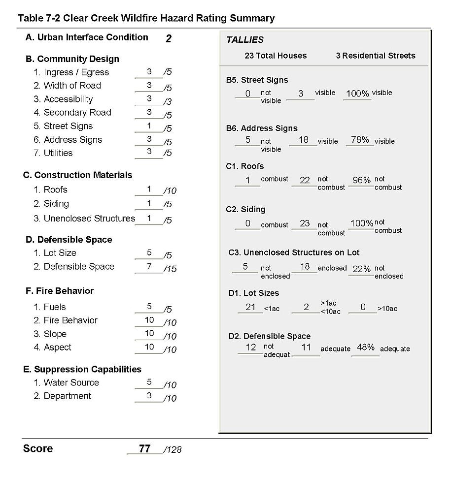 |
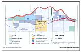
Figure 7-1Clear Creek Fire History and Proposed/Planned Mitigation Projects |
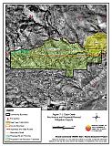 |
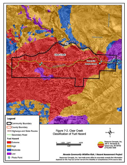
Figure 7-2Clear Creek Classification of Fuel Hazard |
 |
Clear Creek Fuel Hazard Photo Points
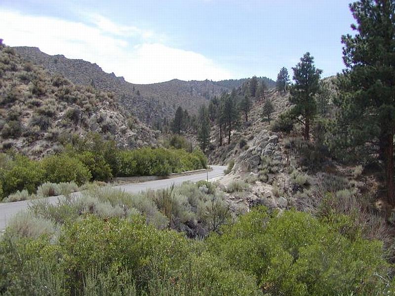
Photo Point 1. Clear Creek Fuel Hazard Photo Point. 4333111N, 257799E, 270°W. Fuels on the east side of the Clear Creek area, southwest of Carson City, consisted of high density sagebrush, bitterbrush, and rabbitbrush. The tree canopy consisted of moderate density Jeffrey pine stands in the uplands and willow and cottonwoods in the riparian areas. Fuel loads were estimated at eight tons per acre and considered a high fuel hazard.
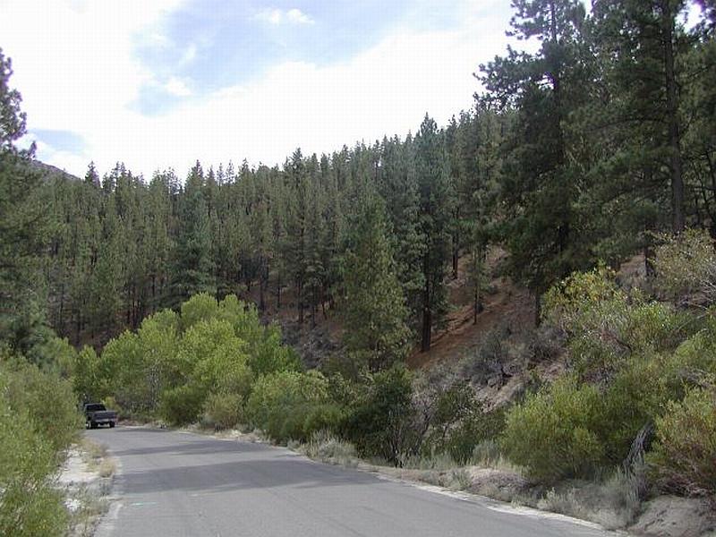
Photo Point 2. Clear Creek Fuel Hazard Photo Point. 4333125N. 2569212E. 110°SE Typical vegetation in the Clear Creek area consisted of dense Jeffrey pine stands with an understory of four to six-foot high sagebrush. Fuel loads were estimated at fourteen tons per acre and considered an extreme fuel hazard.
Photo Point 3. Clear Creek Fuel Hazard Photo Point. 4333055N. 253932E. 90°E. Near the Youth Center in the Clear Creek area, fuels consisted of high density Jeffrey Pine and continuous canopy brush fields of four-foot tall manzanita, sagebrush, and bitterbrush. Both the brush and tree dominated areas were considered extreme fuel hazards.
Figure 7-4Clear Creek Planned Fire Mitigation Projects |
 |