![]()
![]()
8.0 Stewart
8.1 Risk and Hazard Assessment
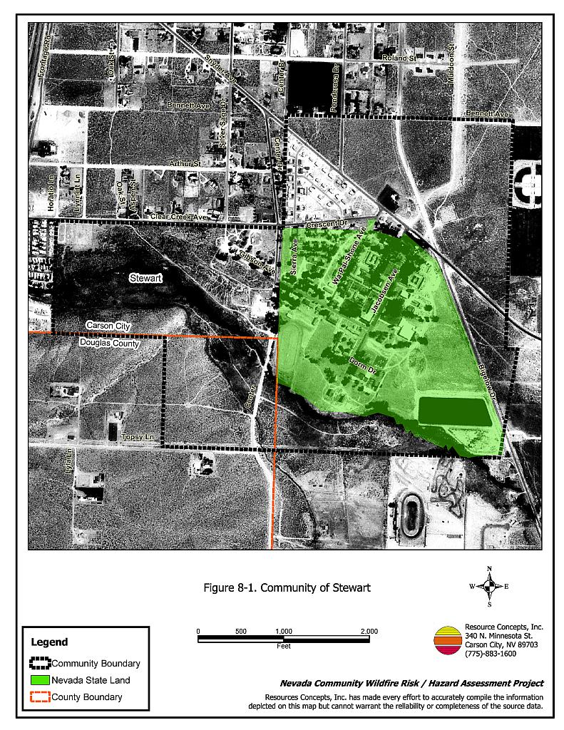
Stewart is located in the southeastern portion of Carson City on Snyder Road, approximately 0.5 miles east of U.S. Highway 395. The Stewart community is the site of housing for the Washoe Tribe. Thirteen residences were evaluated during the community hazard assessment, which resulted in classifying Stewart in the Low Hazard category (36 points). A summary of the values that affect this hazard rating is included in Table 8-2. The wildfire hazards identified in Stewart were the limited address signage on residences and vegetation or debris around some structures in the interface.
8.1.1 Community Design
The wildland-urban interface around Stewart is a classic interface condition. There is a clear line of demarcation between structures and wildland fuels. Wildland vegetation typically does not continue into the development areas, and there are typically more than three structures per acre. All of the lots assessed are on parcels of one acre or less (see Figure 8-1).
- Access: Clear Creek Road and Snyder are the two main access roads to the Stewart community. These roads are between 20 and 24 feet in width and provide adequate access for fire suppression vehicles. No dead-end roads limit the ability for fire suppression equipment to maneuver or turn around. All roads in the community have a grade less than five percent.
- Signage: Residential addresses were visible on most of the homes assessed. Clear and visible residential addresses are important to aid firefighting personnel in locating homes during low visibility conditions that occur during a wildland fire.
- Utilities: All of the utilities were above ground. Power line right-of-ways were properly maintained, which minimizes the possibility of power lines sparking during windstorms and starting fires in nearby vegetation.
8.1.2 Construction Materials
All of the homes assessed in the interface area were built with fire resistant siding materials and non-combustible roofing materials, mainly composition type roofing. None of the homes observed had an unenclosed balcony, porch, deck or other architectural feature that could create drafts and provide areas where sparks and embers can be trapped, smolder, ignite, and rapidly spread fire to the home.
8.1.3 Defensible Space
A majority of the homes in the interface had landscaping that would meet the minimum defensible space requirement to help protect the home and minimize the potential for damage or loss during a wildfire.
8.1.4 Suppression Capabilities
Wildfire Protection Resources
Stewart is provided wildland and structure fire protection by the Carson City Fire Department. The BLM Carson City Field Office also has wildland fire suppression responsibility for Bureau of Indian Affairs lands in Stewart. See Tables 4-2 and 4-3 for additional information on fire protection resources available to Carson City communities.
Water Sources and Infrastructure
Water availability for fire suppression in Stewart includes 500 gpm hydrants within 500 feet of structures. The water system operates on gravity and electrical pump, with portable backup generators available to run the pumps in an emergency. The existing infrastructure for the water delivery system meets the 1997 Uniform Fire Code standards.
Community Preparedness
Stewart is included in the Carson City emergency plan and disaster plan. Development plans for the Nevada State Land are reviewed by the Carson City Fire Department.
8.1.5 Factors Affecting Fire Behavior
Vegetation, vegetative litter, and topography contribute to the potential fire hazard around wildland-urban interface communities. The vegetative fuel density in the Stewart interface area is moderate, estimated at four tons per acre. Fuels around the community consist primarily of big sagebrush rabbitbrush, desert peach, and Mormon tea with a cheatgrass understory. Typical shrub heights range between four and five feet. The terrain is mostly flat (five percent or less slope). The fire behavior potential in Stewart is considered moderate due to the moderate fuel hazard, flat terrain, and high wind exposure. There is a significant wildfire history in the area adjacent to Stewart, due to both lightning and man-caused fires. The predominant wind direction is from the south-southwest in the late afternoon.
8.1.6 Previous Fire Hazard Reduction Projects
The Washoe Tribe Environmental Protection Department has completed two 20 to 30-foot wide fuelbreaks by mowing sagebrush to a six-inch height along Clear Creek Road from the cemetery to Center Street, and south of the cemetery along the Washoe Tribe property boundary. The department has been chipping brush piles remaining from previous brush removal projects and is in the process of planning additional fuel reduction treatments for the Stewart community.
8.1.7 Fire Behavior Worst-Case Scenario
The worst-case wildfire scenario for Stewart would be a wind driven wildland fire starting south or southwest of the community or on one of the large undeveloped open space areas within the community, in the mid-afternoon on a high hazard day. In high wind conditions, a fire could rapidly spread through the moderately dense sagebrush and quickly threaten some of the residences in the community.
8.1.8 Ignition Risk Assessment
Stewart has a high ignition risk based on the ignition history reported for the area (Figure 3-2).
8.2 Risk and Hazard Reduction Recommendations, Roles, and Responsibilities
The Stewart risk and hazard reduction recommendations address the primary concern regarding protection of existing and future development in the wildland-urban interface area. Other recommendations pertain to community coordination and public education efforts that could be undertaken to enhance fire safety in Stewart.
8.2.1 Defensible Space Treatments
Defensible space is an essential first line of defense for residential structures. Significantly reducing or removing vegetation within a prescribed distance from structures (a minimum of 30 feet to 200 feet depending upon slope and vegetative fuel type) reduces fire intensity and improves firefighter and homeowner chances for successfully defending a structure against oncoming wildfire. Improving address identification improves firefighters’ ability to locate structures during smoky conditions.
Homeowner Responsibilities and Nevada Division of State Lands - Stewart Buildings and Grounds
- Remove, reduce, and replace vegetation around homes according to the guidelines in Appendix F. This area should be kept:
- Lean: There are only small amounts of flammable vegetation,
- Clean: There is no accumulation of dead vegetation or other flammable debris, and
- Green: Existing plants are healthy and green during the fire season.
- Remove debris and flammable materials from within the defensible space area.
- Where cheatgrass has become dominant within the defensible space area, it should be mowed prior to seed set or treated with an application of a pre-emergent herbicide. Treatments may need to be repeated for several years to ensure that the bank of unwanted grass seed has been depleted. Refer to Appendix F for a recommended seed mixture and planting guidelines that can be used for cheatgrass removal.
- Store firewood a minimum distance of thirty feet from structures.
- Spark arresting screens should be installed on chimneys.
- Immediately dispose of cleared vegetation when implementing defensible space treatments. The material dries quickly and poses a fire hazard if left on site.
- Maintain this defensible space as needed to keep the space lean, clean, and green.
8.2.2 Fuel Reduction Treatments
Electric Utility Company Responsibilities
- Reduce vegetation a minimum distance of fifteen feet from all utility poles.
- Reduce vegetation a minimum distance of thirty feet from the transfer station located near the corner of Bigelow and Snyder.
Carson City Fire Department Responsibilities
- Reduce vegetation a minimum distance of three feet around all fire hydrants to improve visibility for firefighters.
8.2.3 Community Coordination
Many of the most effective activities aimed at reducing the threat of wildfire for the Stewart community require that individual homeowners coordinate with each other, the Washoe Tribe, and with local fire authorities. Defensible space, for example, is more effective in small communities when applied uniformly throughout entire neighborhoods. Public education and awareness, neighbors helping neighbors, and proactive individuals setting examples for others to follow are just a few of the approaches that will be necessary to meet the fire safe goals in the community. Disposal of biomass generated from defensible space and fuel reduction treatments can sometimes be most efficiently handled through community programs.
Property Owner Responsibilities
- Form a local chapter of the Nevada Fire Safe Council in conjunction with the Washoe Tribe of Nevada and California. The Nevada Fire Safe Council proposes to work on solutions that reduce the risk of loss of lives and property from wildfires in Nevada’s communities. Through establishment of a local Chapter, communities become part of a large information-sharing network that receives notifications of programs and funding opportunities for fire mitigation projects such as those listed in this report. The Nevada Fire Safe Council will accept and manage grants and contracts on the Chapter’s behalf through its non-profit status. The Nevada Fire Safe Council provides assistance and support to communities to complete fire safe plans, set priorities, educate and train community members, and promote success stories of its members. For more information on forming a chapter, contact:
Nevada Fire Safe Council
1187 Charles Drive
Reno, Nevada 89509
www.nvfsc.org - Assure that residential addresses are visible from the road. Address characters should be at least four inches high, reflective, and composed of non-flammable material. Improving visibility of addresses will make it easier for those unfamiliar with the area to navigate an area under smoky conditions in the event of a wildland fire.
8.3 Summary of Recommendations
| Responsible Party | Recommended Treatment | Recommendation Description |
|---|---|---|
| Property Owners | Defensible Space Treatments | Remove, reduce, and replace vegetation around homes according to the guidelines in Appendix F. Maintain defensible space as needed to keep the space lean, clean, and green. |
| Community Coordination | Form a local chapter of the Nevada Fire Safe Council. Improve address visibility. |
|
| Fuel Reduction Treatments | Reduce fuels at least ten feet along both sides of private driveways that are longer than 200 feet. | |
| Nevada Division of State Lands | Defensible Space Treatments | Remove, reduce, and replace vegetation around homes according to the guidelines in Appendix F. Maintain defensible space as needed to keep the space lean, clean, and green. Improve address visibility. |
| Electric Utility Company | Fuel Reduction Treatments | Reduce vegetation a minimum distance of fifteen feet from all utility poles. Reduce vegetation a minimum distance of thirty feet from the transfer station located near the corner of Bigelow and Snyder. |
| Carson City Fire Department | Fuel Reduction Treatments | Reduce vegetation a minimum distance of three feet around all fire hydrants to improve visibility for firefighters. |
Table 8-2Stewart Colony Wildfire Hazard Rating Summary |
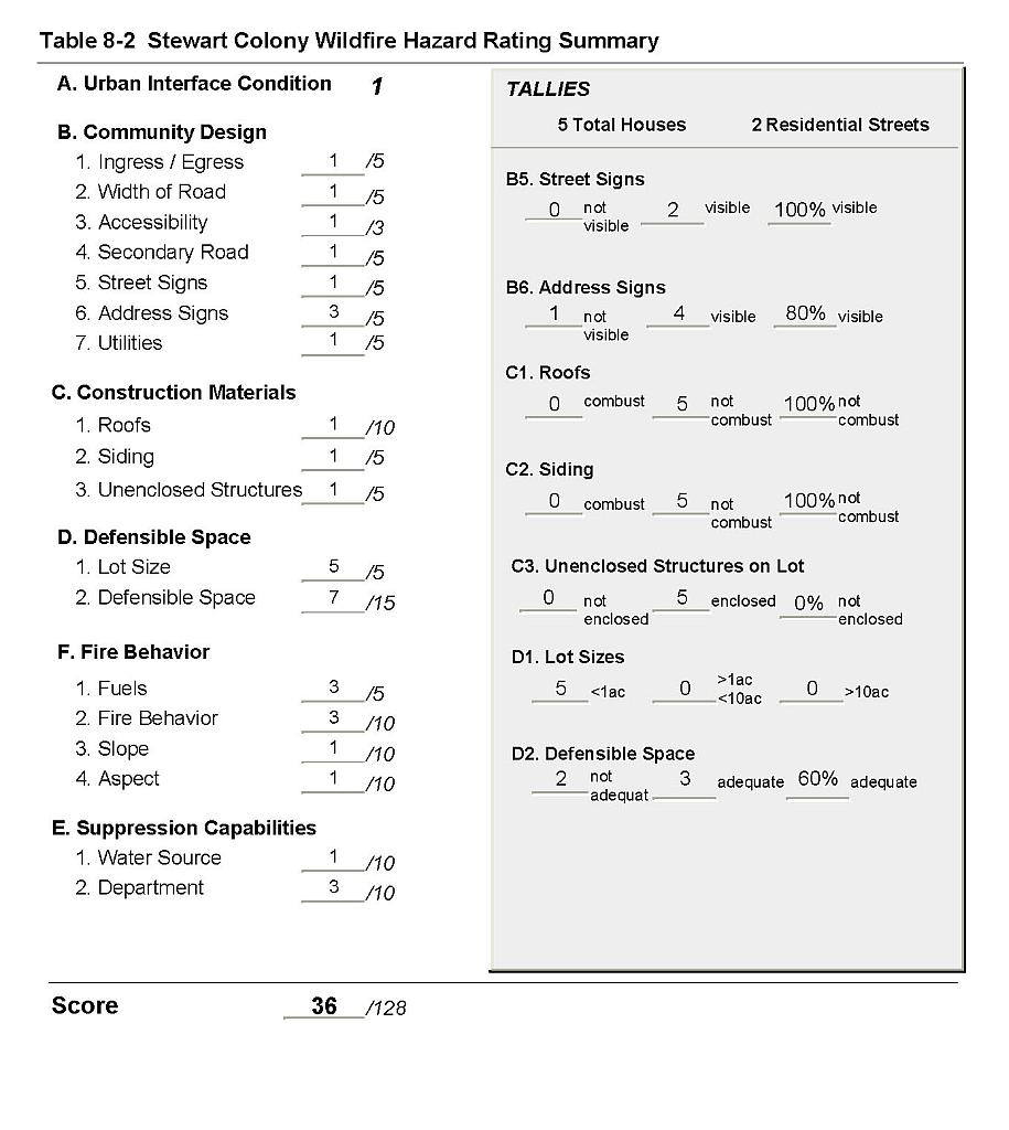 |
Figure 8-1Community of Stewart |
 |