![]()
![]()
6.0 Eastgate
6.1 Risk and Hazard Reduction
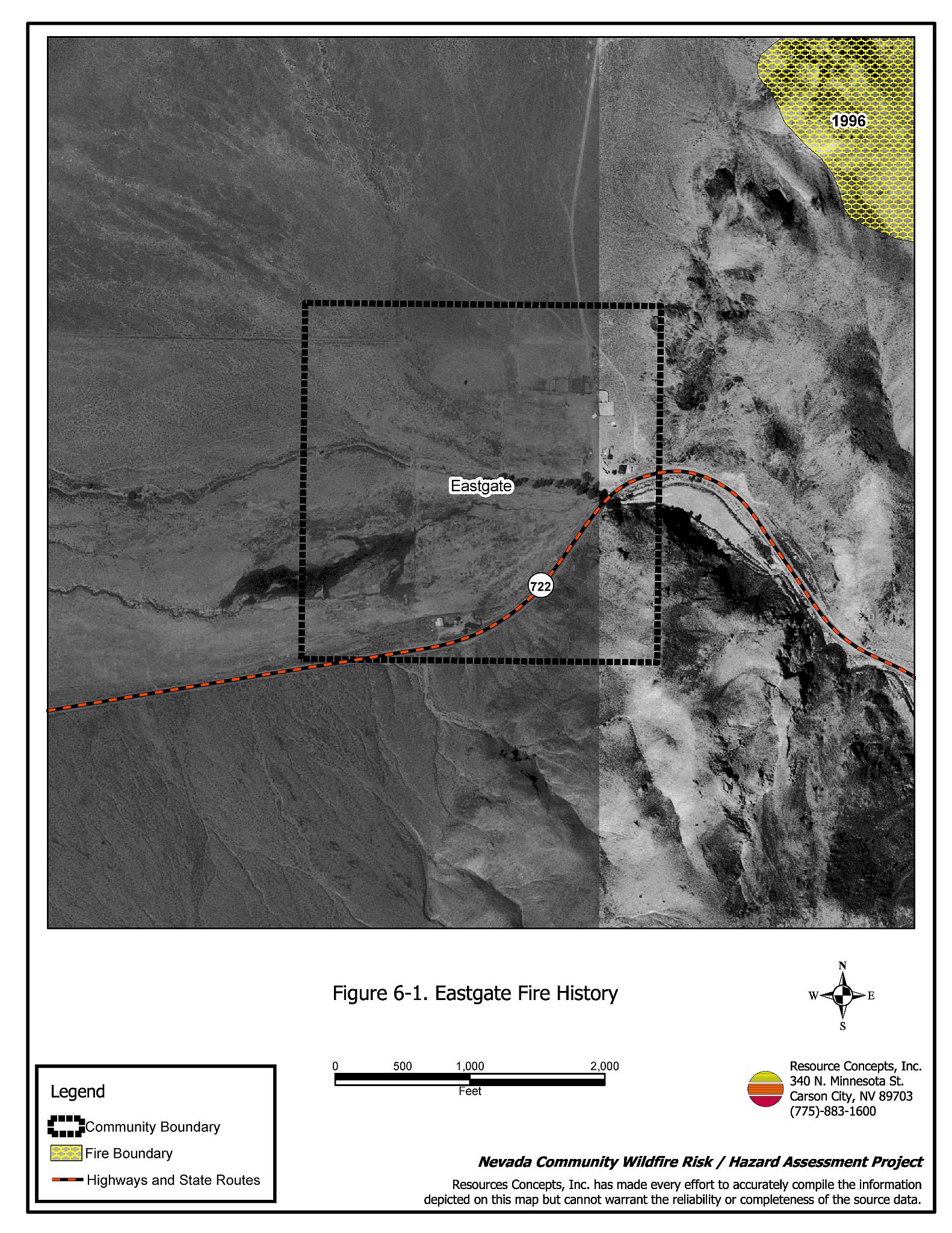
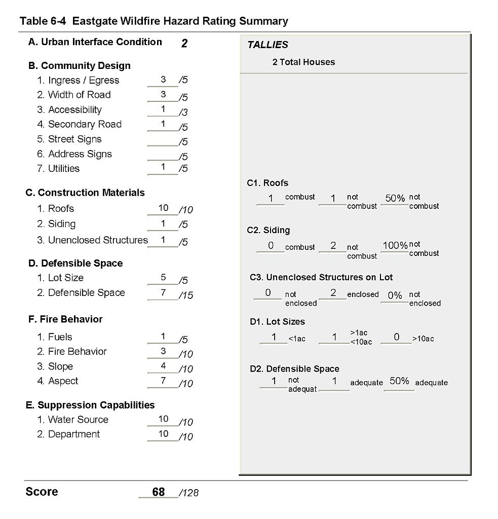
Eastgate is located in the southeastern portion of Churchill County on State Route 722. Eastgate has two residential structures, but only one may actually be occupied. The hazard assessment resulted in classifying Eastgate in the High Hazard category (68 points). The primary factors that contribute to Eastgate’s hazards are the lack of a community water system, the lack of fire suppression resources, the isolated location of the community at the mouth of a narrow canyon, and the steep topography to the north and to the east of the community.
6.1.1 Community Design
Eastgate is a rural interface community. The ranch structures are clustered together at the east boundary of the property, at the mouth of a narrow, east-west running canyon.
- Roads: SR 722 is the primary transportation route to Eastgate; it is a paved two-lane highway, and is of a typical width between twenty to 24-feet.
- Signage: Street signs and address visibility were considered Not Applicable in Eastgate. All residences were easily visible and could be located in the event of a wildfire.
- Utilities: Electric utilities were all above ground. In general, power line right-of-ways were adequately maintained and pose only a low ignition risk to the community.
6.1.2 Construction Materials
Both of the structures in the interface were built with non-combustible siding materials. One of the homes had fire resistant roofing materials. Neither of the structures observed had unenclosed balconies, porches, decks, or other architecture features that could create drafts and provide areas where sparks and embers could smolder and rapidly spread fire if ignited.
6.1.3 Defensible Space
One of the structures had landscaping that met the minimum recommended defensible space to protect the home from damage or loss during a wildfire.
6.1.4 Suppression Capabilities
Wildfire Protection Resources
There is no organized volunteer or paid fire department in Eastgate. Fire protection resources are available from the Fallon/Churchill VFD or Fallon NAS (by request). Additional resources are available through the Bureau of Land Management, dispatched from the Sierra Front Interagency Dispatch, Minden, Nevada. Tables 6-1 and 6-2 list the types of wildfire resources, cooperating partners and equipment available to Eastgate to respond to a reported wildland fire. For any of the fire protection agencies the minimum response time to Eastgate is approximately sixty to ninety minutes depending upon resource availability.
| Type of Equipment | Amount | Cooperating Partner |
|---|---|---|
| Water Tender (dump truck with slip-in tanks) | 2 | Cold Springs NDOT Maintenance Station |
| Type 1 Engine Type 3 Engine Type 1 Water Tender (4,000 gal.) Command Officer |
6 2 3 1 |
Fallon/Churchill VFD |
| Type 1 Engine Type 3 Engine Type 6 Engine Type 1 Water Tender |
1 1 1 1 |
Fallon Naval Air Station |
| Type of Equipment | Amount of Equipment | Cooperating Partner (Resource Location) |
|---|---|---|
| Type 3 Engine Water Tender Incident Command Type 1 Air Tanker Air Attack |
1 1 1 1 1 |
The closest available Bureau of Land Management resources dispatched by the Sierra Interagency Dispatch Center in Minden, Nevada |
| Source: Personal Communication with Leonard Waking Fire Management Officer BLM Carson City Field Office, Steven Edgar Fire Mitigation and Education Specialist BLM Carson City Field Office, Ed Harris Equipment Manager Fallon/Churchill VFD, Stuart Cook Fire Management Officer Fallon Naval Air Station, and Phil Cammarata Maintenance Manager Nevada Department of Transportation. | ||
Water Sources and Infrastructure
There is no community water system in Eastgate. It is unknown whether the property owner has any water sources onsite. The closest known water sources are the same as those available for fire suppression in Middlegate and Cold Springs and include drafting sources that may be used with landowner permission:
- Community well at Middlegate Store/Cafe.
- One windmill/stock tank 1/4 mile west of Middlegate.
- One irrigation pump at ranch 1/4 mile east of Middlegate.
- One 1,000-gallon water storage tank and well at the NDOT Maintenance Station in Cold Springs.
Detection and Communication
Fires are reported in the Eastgate area through 911 calls to the Churchill County Sheriff’s Office.
Fires are communicated to fire response personnel through the use of:
- Fire Dispatch through the Churchill County Sheriff’s Office in Fallon.
6.1.5 Factors That Affect Fire Behavior
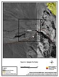
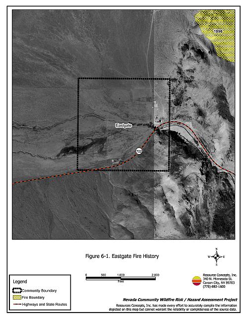
Eastgate is located at the mouth of a narrow canyon with prevailing winds from the west/southwest. The terrain is flat with less than five percent slope west of Eastgate, but it is very steep immediately east and north. In 1996 a 4,415-acre fire burned to the northeast of Eastgate. Fuel density is light in the area surrounding the structures, estimated at less than one ton per acre. Fuels consist primarily of sagebrush, greasewood, Indian ricegrass, rabbitbrush, and bottlebrush squirreltail, with an invasion of cheatgrass. The light fuels around Eastgate were considered a low fuel hazard at the time of the assessment; however, annual cheatgrass production could dramatically increase in years of high precipitation and would pose a moderate fuel hazard to the community.
6.1.6 Worst Case Wildfire Scenario
The worst-case scenario for Eastgate would be a wind-driven wildland fire that starts southwest of Eastgate and spreads into the structures and through the canyon. Historical fire records indicate that ignition risks are moderate. Flame lengths would be low because of the sparse, low vegetation and would not likely ignite structures.
6.1.7 Ignition Risk Assessment
The ignition risk in the Eastgate area is moderate, based primarily on the record of historical ignitions. The lack of water and local fire suppression capabilities contributes to the possibility of an ignition spreading before fire suppression resources could arrive. The risk of property loss due to wildland fire is low due to the sparse, low brush in and around the community. The primary ignition risk factor in Eastgate is lightning. In years of increased moisture and cheatgrass growth, the ignition risk would be higher due to increased fuel loading.
6.2 Risk and Hazard Reduction Recommendations, Roles, and Responsibilities
Eastgate is a very small community with no local fire suppression resources. Recommendations to reduce the risk of property loss due to a wildland fire are detailed below and summarized in Table 6-3.
6.2.1 Property Owner Responsibilities
Defensible Space Treatments
Density and type of fuel around a home determines the potential fire exposure levels to the home. The goal of defensible space is to reduce the chances of a wildfire spreading into adjacent property, igniting homes, and reducing the risk of loss from a wildfire. General guidelines for creating defensible space around residences and structures in the community are given below, and illustrated in the Defensible Space Guidelines in Appendix D. See also the Homeowner’s Annual Checklist in Appendix D for additional information.
- Remove, reduce, and replace vegetation around homes according to the guidelines in Appendix D. This area should be kept:
- Lean: There are only small amounts of flammable vegetation.
- Clean: There is no accumulation of dead vegetation or other flammable debris.
- Green: Existing plants are healthy and green during the fire season.
- Maintain defensible space annually.
- Immediately dispose of cleared vegetation when implementing defensible space treatments. This material dries quickly and poses a fire hazard if left on site.
- Clear all vegetation and combustible materials around propane and above ground fuel tanks for a minimum distance of ten feet.
- Where cheatgrass has become dominant within the defensible space area it should be mowed prior to seed set, or an application of a pre-emergent herbicide can be used. Mowing may need to be repeated the following year to ensure that the seed bank of unwanted grasses has been depleted. Refer to Appendix E for approved seed mixes and planting guidelines that can be used in conjunction with removal of this annual grass.
6.2.2 Bureau of Land Management Responsibilities
Public Education
- Distribute copies of the publication “Living With Fire.” This publication is free of charge. Copies can be requested for the University of Nevada Cooperative Extension, (775) 784-4848.
6.3 Summary of Recommendations
| Responsible Party |
Recommended Treatment | Recommendation Description |
|---|---|---|
| Property Owners | Defensible Space Treatments | Remove, reduce, and replace vegetation around homes according to the guidelines in Appendix D. Maintain defensible space as needed to keep the space lean, clean, and green. |
| Bureau of Land Management | Public Education | Distribute copies of the publication “Living With Fire.” This publication is free of charge. Copies can be requested for the University of Nevada Cooperative Extension, (775) 784-4848. |
Figure 6-1Eastgate Fire History |
 |
Table 6-4Eastgate Wildfire Hazard Assessment Rating Summary |
 |