![]()
![]()
7.0 Fallon
7.1 Risk and Hazard Assessment
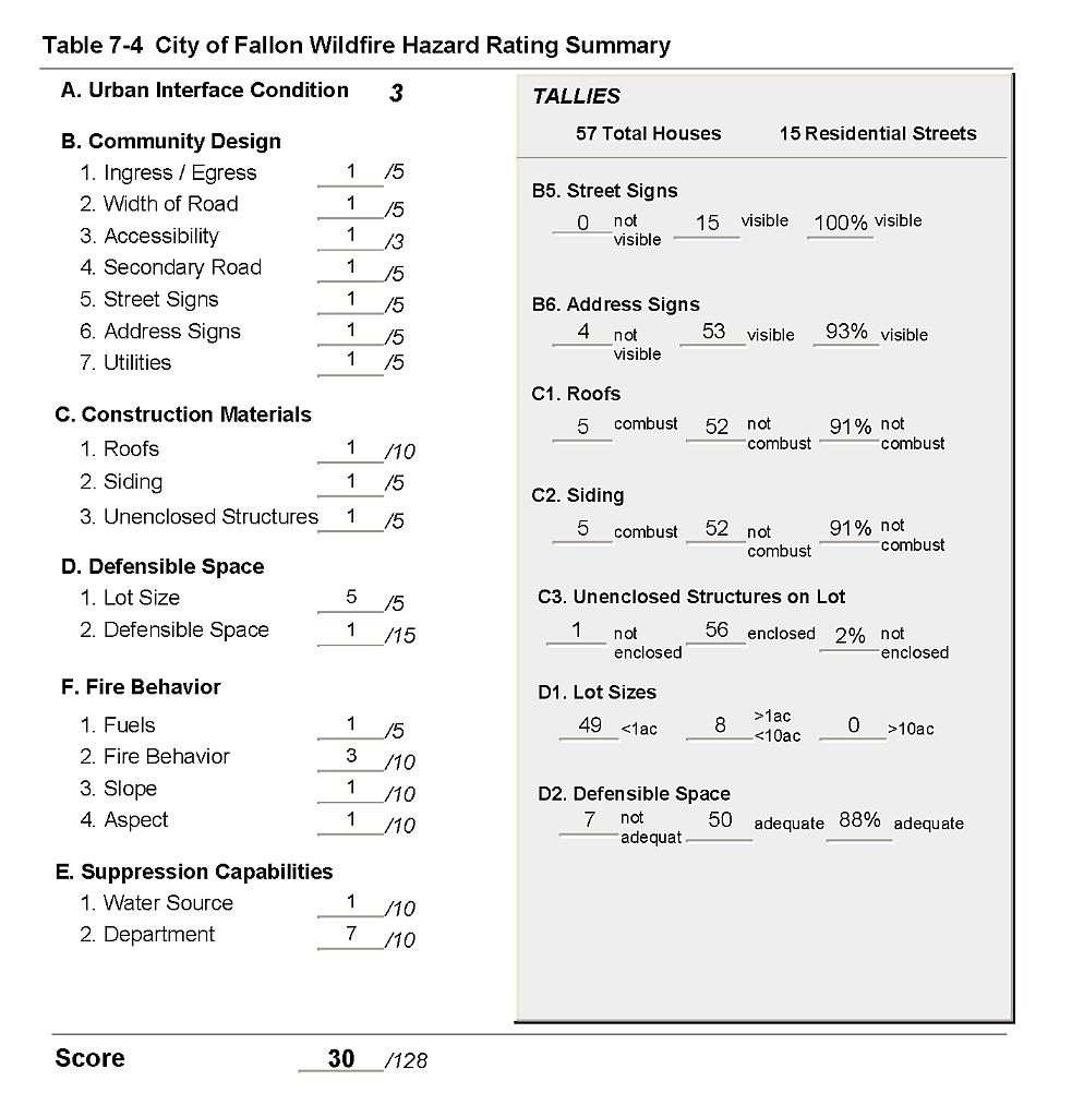
The City of Fallon, located in western Churchill County, is surrounded by the agricultural land of the Fallon Outskirts. There were approximately 57 residences observed in the wildland-urban interface area of Fallon. The hazard assessment resulted in classifying Fallon, as a whole, in the Low Hazard category (30 points). A summary of the factors that contributed to the hazard rating is included in Table 7-4. The score is attributed primarily to the sparse vegetation surrounding the community, the buffer of agricultural land to the south, and the fire-safe construction of many structures in the interface.
7.1.1 Community Design
Fallon is a classic interface condition community. Most residences have a clear line of demarcation between the structure and any wildland fuels. Several residential neighborhoods have block walls and dirt roadways between the wall and the wildland area that serve as fuelbreaks. Of the 57 houses included in the assessment- 49 were on lots of less than one acre, and eight were on lots of between one and ten acres.
- Roads: The primary access routes in and out of Fallon are Interstate 95 and U.S. Highway 50. Both of the highways are paved, two-lane roads with a typical 24-foot width, allowing adequate room for fire suppression equipment to maneuver. Most of the secondary roads in the community are paved roads. These roads typically have less than a five percent gradient and provide adequate width and turning radius for fire suppression equipment.
- Signage: Street signs were present and visible along all streets. Residential addresses are visible on 93 percent of the homes surveyed. Clear and visible signage is important to assist fire suppression personnel in locating at risk residences during poor visibility conditions that often occur during a wildland fire.
- Utilities: All electric power utilities were above ground. In general, power line right-of-ways were adequately maintained and pose only a low ignition risk to the community.
7.1.2 Construction Materials
Ninety-one percent of homes observed in the interface area were built with fire-resistant siding and roofing materials. Fire-resistant roofing includes such materials as composition, metal, or tile roofing. Only two percent of the homes observed had an unenclosed balcony, porch, deck, or other architectural feature. Such features can create drafts and provide areas where sparks and embers can lodge, smolder, and rapidly spread fire to the home itself.
7.1.3 Defensible Space
Eighty-eight percent of the homes had landscaping that met the minimum defensible space criteria to protect the home from damage or loss during a wildfire.
7.1.4 Suppression Capabilities
Wildfire Protection Resources
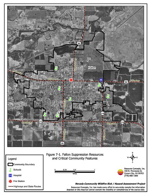
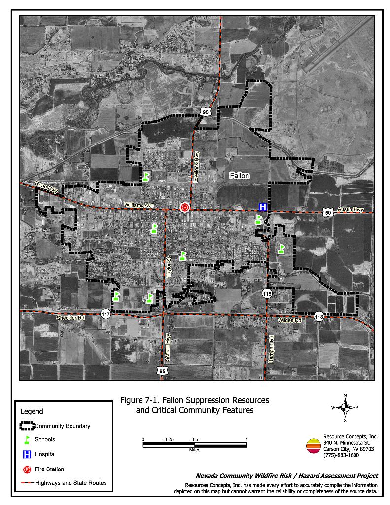
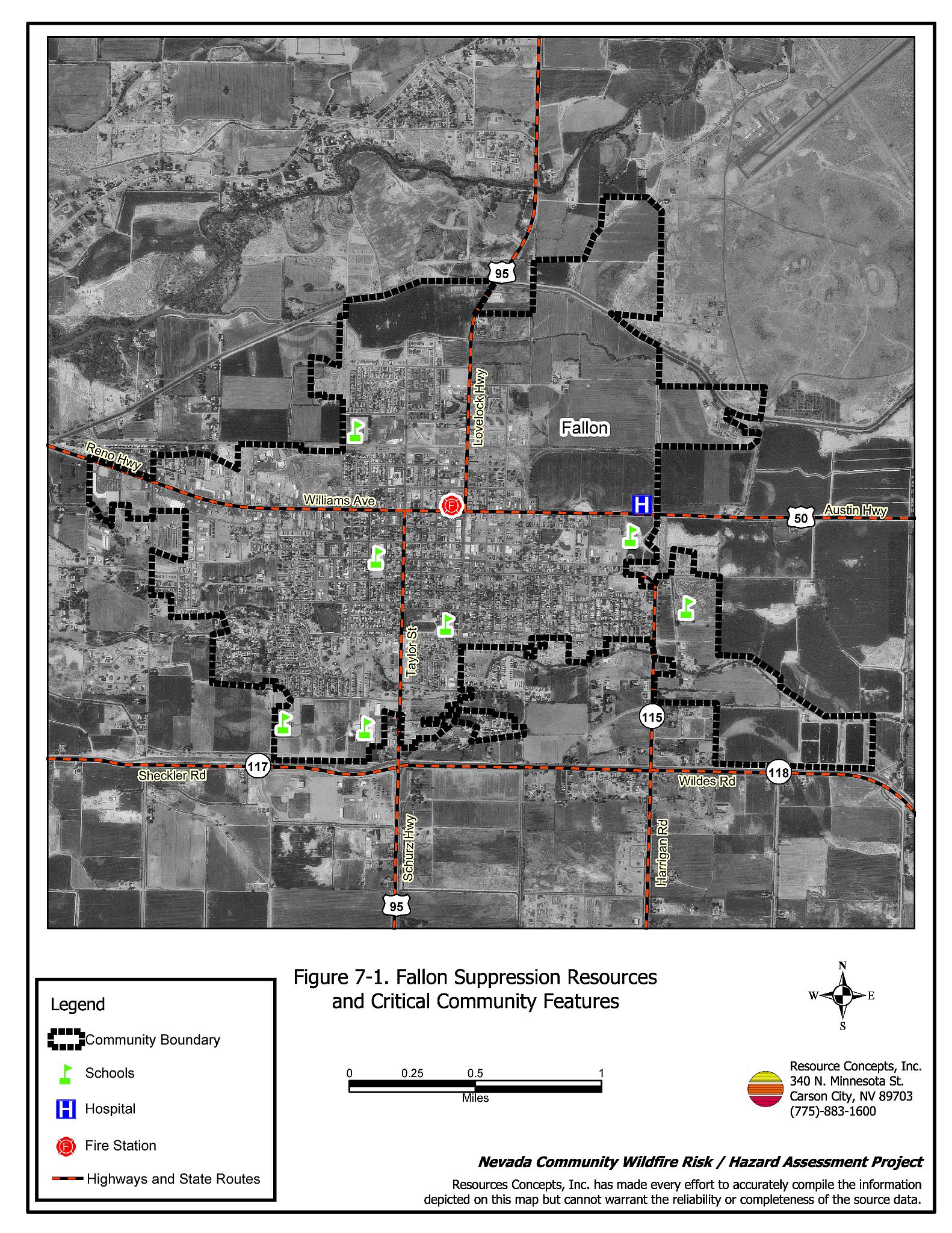
The City of Fallon is protected by the 41-member Fallon/Churchill VFD. The Fallon/Churchill VFD received the nation’s first Insurance Services Offices Class 1 Volunteer Fire Department rating. Additional resources are available through the Bureau of Land Management, dispatched from the Sierra Front Interagency Dispatch, Minden, Nevada and the Fallon Naval Air Station Fire Department (by request). Tables 7-1 and 7-2 list the types of wildfire resources, cooperating partners, and equipment available to Fallon to respond to a reported wildland fire. Some volunteers may be unable to respond immediately to fire calls during typical working hours, and response from outside resources will be affected by equipment and personnel availability.
| Type of Equipment | Amount of Equipment | Cooperating Partner (Resource Location) |
|---|---|---|
| Type 1 Engine Type 3 Engine Type 1 Water Tender (4,000 gal.) Command Officer |
6 2 3 1 |
Fallon/Churchill VFD |
| Type 1 Engine Type 3 Engine (1) Type 6 Engine Type 1 Water Tender |
1 1 1 1 |
Fallon Naval Air Station (by request only) |
| (1) The Type 3 engine listed under the Fallon Naval Air Station was in a state of disrepair at the time of the assessment. | ||
| Type of Equipment | Amount of Equipment | Cooperating Partner (Resource Location) |
|---|---|---|
| Type 3 Engine Water Tender Incident Command Type 1 Air Tanker Air Attack |
1 1 1 1 1 |
The closest available Bureau of Land Management resources dispatched by the Sierra Interagency Dispatch Center in Minden, Nevada |
| Source: Personal Communication with Leonard Waking Fire Management Officer BLM Carson City Field Office, Steven Edgar Fire Mitigation and Education Specialist BLM Carson City Field Office, Ed Harris Equipment Manager Fallon/Churchill VFD, and Stuart Cook Fire Management Officer Fallon Naval Air Station. | ||
Water Sources and Infrastructure
Water availability for fire suppression in Fallon includes:
- 500 gpm hydrants within 1,000 feet of structures.
- One 1.8 million gallon storage tank.
- One 1 million gallon water tank.
- Irrigation canals that can be used as a drafting or dip site with the permission of property owners.
The Project Team Fire Specialists noted three wells with pipes or filler valves that could be used to fill fire suppression equipment in case of fire. The community water system relies on electrical pumps. There is a backup emergency generator to run the pumps, in the event of a power outage. Maintenance of the backup generator is the responsibility of the water system owner.
Detection and Communication
Fires are reported in the Fallon area through 911 calls to the Churchill County Sheriff’s Office in Fallon.
Fires are communicated to fire response personnel through:
- Emergency Dispatch through the Churchill County Sheriff’s Office in Fallon.
- Radios using the following frequency: 155.055.
- Pagers
The Churchill County Sheriff’s Office has access to the state mutual aid frequencies and the radio system is compatible with neighboring agencies. BLM fire suppression personnel and equipment are dispatched by the Sierra Front Interagency Dispatch Center in Minden, Nevada.
7.1.5 Factors Affecting Fire Behavior
The vegetative fuel density in the Fallon interface area was primarily light. Fuels consisted of salt desert shrub vegetation such as greasewood and annual and perennial grasses. Fuels along the irrigation canals that traverse the community consisted of Russian thistle, cattails, cottonwood, and poplar. The vegetative fuel load was estimated to be less than two tons per acre and considered a low fuel hazard. The terrain is fairly flat. The predominant wind is from the west/southwest in the late afternoon.
At the boundary of the City of Fallon and the agricultural Fallon Outskirts, there were large accumulations of dried Russian thistle tumbleweeds on fences. In the irrigation canals that traverse the community, large amounts of this dry vegetation were present along with fine fuels, downed tree limbs, and leaf biomass. In the last 24 years, there have been no large wildfires near the City of Fallon.
7.1.6 Fire Behavior Worst-Case Scenario
The worst-case scenario for a major wildfire in the Fallon area would occur as a wind-driven event burning through the irrigation canals that traverse the community, spreading to vacant lots with high accumulations of debris and biomass, and/or occurring along a fence line with accumulated dry Russian thistle and other biomass. A fire in an irrigation ditch meant to clear vegetation could escape and spread through the network of irrigation ditches that traverse the community. If the fire began during normal working hours, there could be a limited or delayed response by volunteer firefighters, giving the fire a chance to spread before fire suppression resources could respond. The scenario would be worsened if mutual aid resources were unavailable or assigned to an emergency situation elsewhere.
7.1.7 Ignition Risk Assessment
The risk assessment resulted in classifying Fallon with a low ignition risk potential due to the low, sparse brush in and around the community and the irrigated lands to the south that provide a buffer from any wildfire that may occur and spread from that direction. The primary ignition risk factor in Fallon is ditch burning.
7.2 Risk and Hazard Reduction Recommendations, Roles, and Responsibilities
The Fallon risk and hazard reduction recommendations focus on homeowner and agency efforts in defensible space, fuel reduction, and power line clearance and maintenance. Other recommendations pertain to community coordination and public education efforts that could be initiated to enhance fire safety in Fallon. Recommendations are detailed below and summarized in Table 7-3.
7.2.1 Property Owner Responsibilities
Defensible Space
Density and type of fuel around a home determines the potential fire exposure levels to the home. The goal of defensible space is to reduce the chances of a wildfire spreading into adjacent property and igniting homes, and to reduce the risk of loss from a wildfire. General guidelines for creating defensible space around residences and structures in the community are given below, and illustrated in the Defensible Space Guidelines in Appendix D. See also the Homeowner’s Annual Checklist in Appendix D for additional information.
- Remove, reduce, and replace vegetation around homes according to the guidelines in Appendix D. This area should be kept:
- Lean: There are only small amounts of flammable vegetation.
- Clean: There is no accumulation of dead vegetation or other flammable debris.
- Green: Existing plants are healthy and green during the fire season.
- Maintain defensible space annually.
- Immediately dispose of cleared vegetation when implementing defensible space treatments. This material dries quickly and poses a fire hazard if left on site.
- Prune trees so that the branches are at least fifteen feet away from chimneys and/or structures. Dead and diseased branches should be removed and disposed of along with other biomass.
- Clear all vegetation and combustible materials around propane tanks for a minimum distance of ten feet.
- Make sure residential addresses are visible from the road. Address numbers should be fire resistant and at least four inches high. Improving address visibility will make it easier for those unfamiliar with the area to navigate during a wildland fire event.
7.2.2 Fallon/Churchill VFD Responsibilities
Fuel Reduction Treatments
- Remove or mow vegetation within ten feet of all fire hydrants to improve visibility and access by fire personnel.
Community Coordination
- Incorporate Fire Safe Community Planning Recommendations for New Developments in development plan reviews. See Appendix E for an example.
- Implement either a call-in burn program in which landowners must first call the Fallon/Churchill VFD before burning, or a burn permit program. A sample burn permit is included in Appendix E.
Public Education
- Distribute copies of the publication “Living With Fire” to all property owners. This publication is free of charge. Copies can be requested from the University of Nevada Cooperative Extension, (775) 784-4848.
7.2.3 Churchill County Responsibilities
Fuel Reduction Treatments
- Reduce vegetation and maintain county road shoulders by mowing to a height of not more than four inches at least fifteen feet from the edge of pavement on both sides of the road. This will reduce ignition risk and create a firebreak. The biomass should be quickly removed to an appropriate site for disposal.
Community Coordination
- Development and enforcement of county laws, regulations, and ordinances that support implementation and maintenance of defensible space and address fuel reduction responsibilities for absentee homeowners and vacant lots in the communities of Fallon and Fallon Outskirts.
7.2.4 Railroad Responsibility
Fuel Reduction Treatments
- Reduce vegetation to a minimum distance of fifteen feet along both sides of the railbed. The biomass should be quickly removed to an appropriate site for disposal.
7.2.5 Utility Company Responsibilities
Fuel Reduction Treatments
- Clear and maintain a minimum distance of thirty feet from electrical transfer station fencelines free of all vegetation.
- Reduce vegetation to maintain a minimum distance of fifteen feet from all utility poles.
- The biomass should be quickly removed to an appropriate site for disposal.
7.3 Summary of Recommendations
| Responsible Party |
Recommended Treatment | Recommendation Description |
|---|---|---|
| Property Owners | Defensible Space Treatments | Remove, reduce, and replace vegetation around homes according to the guidelines in Appendix D. Maintain defensible space as needed to keep the space lean, clean, and green. Improve address visibility. |
| Churchill County | Fuel Reduction Treatments | Reduce vegetation and maintain county road shoulders by mowing to a height of not more than four inches and a width of fifteen feet from the edge of pavement on both sides of the road. |
| Community Coordination | Development and enforcement of county laws, regulations, and ordinances that support implementation and maintenance of defensible space and address fuel reduction responsibilities for absentee homeowners and vacant lots in the communities of Fallon and Fallon Outskirts. | |
| Railroad | Fuel Reduction Treatments | Reduce vegetation to maintain a minimum distance of fifteen feet along each side of the railroad. Biomass should be quickly removed to an appropriate site for disposal. |
| Fallon/Churchill VFD | Fuel Reduction Treatments | Clear weeds within ten feet of all fire hydrants. The biomass should be quickly removed to an appropriate site for disposal. |
| Community Coordination | Incorporate Fire Safe Community Planning Recommendations for New Developments in development plan reviews. See Appendix E for an example. | |
| Public Education | Distribute copies of the publication “Living With Fire” to all property owners. | |
| Utility Company | Fuel Reduction Treatments | Clear all vegetation within thirty feet of electrical transfer station fencelines. Clear all vegetation to a minimum distance of fifteen feet from all utility poles. The biomass should be removed to an appropriate site for disposal. |
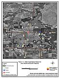
Figure 7-1Fallon Suppression Resources and Critical Community Features |
 |
Table 7-4Fallon Wildfire Hazard Rating Summary |
 |