![]()
![]()
5.0 Cold Creek
5.1 Risk and Hazard Assessment
Cold Creek is located along the north end of the Spring Mountains approximately fifty miles northwest of Las Vegas. The hazard assessment included observations of 72 homes in the interface areas and resulted in classifying Cold Creek in the High Hazard category (68 points). The rating is primarily attributed to limited access, poor defensible space, the potential for extreme fire behavior, and structures without fire resistant building materials. Table 5-3 at the end of this section presents a summary of the community hazard rating values for Cold Creek.
5.1.1 Community Design
The area surrounding the community of Cold Creek is characterized as an intermix wildland-urban interface condition: structures are scattered throughout the wildland area with no clear line of demarcation between wildland fuels, buildings, and open space. All lot sizes are less than one acre in size indicating relatively high-density housing.
- Access: The primary access into Cold Creek is Cold Creek Road, a two-lane dirt road that is at least 24 feet wide. This is the only access road into and out of the community. The road is approximately eleven miles long and intersects with US Highway 95 approximately 32 miles north of Las Vegas. The road gradient is less than five percent. Six of the secondary roads are dead-end streets and do not have adequate turnaround space for fire suppression equipment to maneuver.
- Signage: Street signs are visible on all of the roads in the community. However, residential addresses are not visible on about ninety percent of the homes in the community. Clear and visible street signs and residential addresses are important to aid firefighters in locating homes during low visibility conditions that occur during wildland fires.
- Utilities: Utilities are a low ignition risk because there are no above ground utilities.
5.1.2 Construction Materials
Approximately 95 percent of the homes in the interface are built with non-combustible roofing materials, but only fifteen percent of the homes have fire resistant siding materials. Ninety percent of the homes observed have unenclosed balconies, decks, porches, eaves, or attic vents that can create drafty areas where sparks and embers can be trapped, smolder, ignite, and rapidly spread fire to the house.
5.1.3 Defensible Space
Only ten percent of the homes observed within the Cold Creek community met the landscaping requirement for defensible space to reduce the risk of property damage or loss of a home during a wildfire.
5.1.4 Suppression Capabilities
Wildfire Protection Resources
Clark County Fire Station 82, located in Cold Creek, is a volunteer fire department with eleven members. The next nearest resources for initial attack on a wildland fire in the Cold Creek area would come from Clark County Fire Station 83 and the US Forest Service Station at Indian Springs, approximately twenty miles away. Table 5-1 lists the resources that would most likely be the first to respond to a reported wildland fire. This information is based on data available at the time of interviews with local and regional fire authorities and is subject to change.
| Type of Resource | Amount of Equipment | Cooperating Partner (Resource Location) |
|---|---|---|
| Type 1 Structure Engine Type 6 Quick Attack Engine BLS Rescue |
1 1 1 |
Clark
County Rural Fire Station 82 (Cold Creek) |
| Type 1 Structure Engine Type 6 Cold Creek Engine BLS Rescue |
2 2 1 |
Clark
County Rural Fire Station 83 (Indian Springs) |
| Type 7 Engine Type 4 Brush Engine |
1 1 |
US
Forest Service (Indian Springs Station 83) |
| Source: Steve McClintock, Kurt Leavitt, Mark Blankensop, pers. comm. March 2004. | ||
It is important to note that fire suppression resources administered by federal agencies such as the US Forest Service equipment assigned to Indian Springs are considered national resources and are commonly reassigned to areas of higher severity during the fire season. In response to a wildland fire call, interagency dispatch centers locate and dispatch the closest available resource according to incident command and computer-aided dispatch protocols.
Water Sources and Infrastructure
Water availability for fire suppression in Cold Creek includes 500 gpm hydrants within 500 feet of structures, community wells, one 500,000-gallon storage tank, ponds, and a 5,000-gallon Fold-a-Tank. The water system is gravity-operated.
Fire Protection Personnel Qualifications
Volunteer and career firefighters who would respond to a wildfire near Cold Creek have a minimum of NFPA firefighter I and II training and a limited number have had some wildland firefighting training (National Wildfire Coordinating Group 310-1). The Nevada Division of Forestry and US Forest Service personnel meet minimum requirements per NWCG 310-1.
Work Load
Clark County Fire Department Station 82 responded to eight emergency medical calls and sixteen wildland brush fire calls in 2003.
Detection and Communication
There are no fire lookouts in the Cold Creek area, but reconnaissance flights do occur. Communications by the Clark County Fire Department and neighboring agencies are compatible and there are no gaps in the radio coverage. Pagers, radios, and phones are used to communicate with the firefighters. There are no community sirens for early warnings.
Financial Support
Funding for Clark County Fire Department annual operating expenses comes from the County General Fund, which is generated primarily through property taxes.
Community Preparedness
Clark County has an active Local Emergency Planning Committee and has adopted an all-risk, multi-agency emergency plan. The plan is reviewed annually and updated as needed.
5.1.5 Factors Affecting Fire Behavior
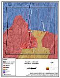
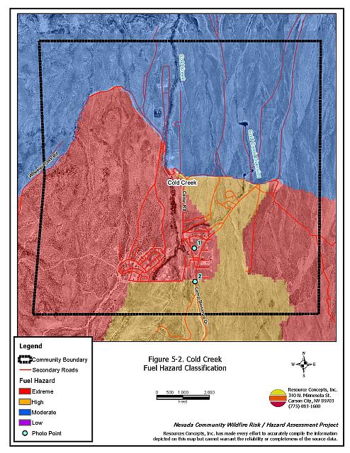
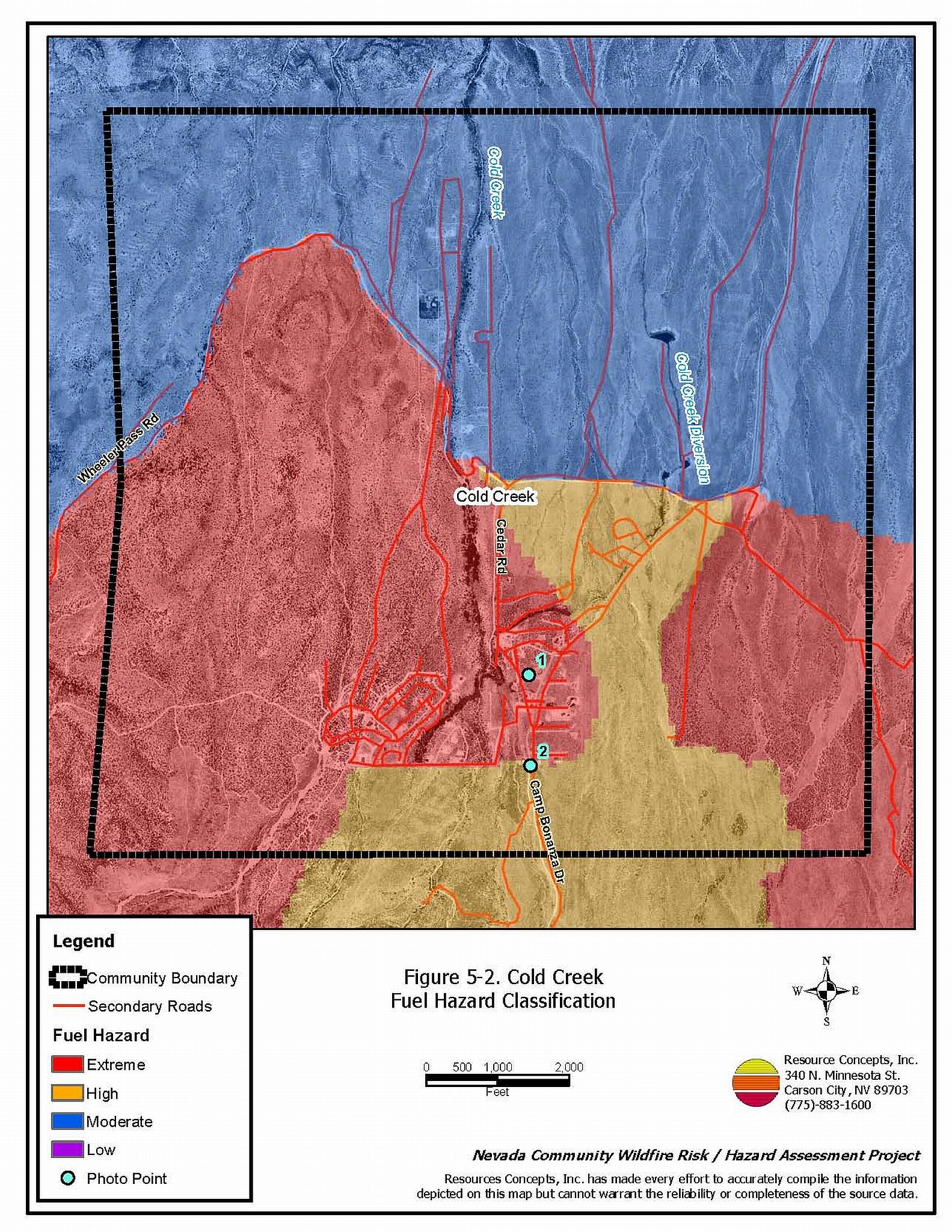
Cold Creek lies at the base of the Spring Mountains and frequently experiences strong downslope winds. Wheeler Pass, northwest of the community, funnels wind into the area. Fuel loading north of the community is moderate, as the vegetation transitions into a Mojave desert shrub plant community at lower elevations. In general, ground fuels are comprised of annual grasses of varying size and density depending on annual precipitation levels. Grazing by wild horses is currently credited with somewhat reducing these fine fuels. Shrubby vegetation in the area is comprised of cliffrose, approximately eight-feet tall, mixed with white bursage and Mormon tea, two to three feet tall. Pinyon and juniper woodlands occur to the south and the west of the community, and these encroaching woodlands contribute to extreme fuel hazard ratings in those areas. The overall fuel hazard condition was rated High to Extreme. Figure 5-2 illustrates the fuel hazard conditions present in and around Cold Creek during the Project Team field visit in March 2004. Photo points are included in Figure 5-3.
5.1.6 Fire Behavior Worst-Case Scenario
The worst-case scenario for the Cold Creek area involves a dry lightning storm in the summer with multiple ignitions on the mountains above and to the south of the community. Winds could drive a fire through heavy brush into the community and exceed initial attack capabilities.
5.1.7 Ignition Risk Assessment
Cold Creek has a moderate ignition risk. The ignition history database recorded three incidents very near the community. A large wildland fire occurred around the community in the early 1980s. The burned area is now characterized by heavy brush that is readily susceptible to ignition, particularly under the low fuel moisture conditions that occur during the summer months.
5.2 Risk and Hazard Reduction Recommendations
The Cold Creek area is vulnerable to a catastrophic wildfire. Initial attack and pre-fire planning will be critical in managing any wildland fire event in the area. Property owners must take an active role in protecting their private property by completing and maintaining defensible space treatments around their homes and initiating fuels reduction treatments within the community. Coordination between the US Forest Service and the Nevada Division of Forestry will be required to construct fuelbreaks at the boundary between federal and private lands, to improve firefighter access and safety, and to slow down or prevent the advance of a wildfire into the community.
5.2.1 Defensible Space
Vegetation density, type of fuel, and slope gradient around a home affect the potential fire exposure levels to the home. These conditions define the defensible space area required for individual homes. The goals of defensible space are to reduce the risk of property loss from wildfire by eliminating flammable vegetation near the home. In turn, this lowers the chances of a wildfire spreading onto adjacent properties and it aids firefighters in their efforts to protect property against an approaching wildfire. Guidelines for establishing and improving defensible space around residences and structures in the community are given below and described in greater detail in Appendix E.
Private Property Owners
- Remove,
reduce, and replace vegetation around homes. Keep this area:
- Lean: There are only small amounts of flammable vegetation.
- Clean: There is no accumulation of dead vegetation or other flammable debris.
- Green: Existing plants are healthy and green during the fire season.
- Clearleaves and debris from roofs and rain gutters.
- Clear brush, weeds, and grasses from within a ten-foot wide strip along either side of driveways.
- Thin existing trees to maintain a minimum distance of thirty feet between tree crowns.
- Prune and remove dead and diseased tree branches. Prune pinyon and juniper branches to a minimum of four feet from the ground, not to exceed one-third of the total tree height. Keep the area beneath remaining trees free of smaller trees, shrubs, duff, and other ladder fuels.
- Enclose wood decks and porches. If this is not possible, keep the area beneath wood decks and porches free of weeds and other flammable debris. Where possible, install screens around unenclosed overhangs.
- Thin shrubs and other brush to a distance equal to twice their height (crown to crown).
- Store firewood a minimum of thirty feet from structures.
- Mow or remove brush growing against fences in the community.
- Clear vegetation and combustible materials from around propane tanks for a minimum of ten feet.
- Immediately remove all cleared vegetation to an approved disposal site. This material dries quickly and poses a fire risk if left on site.
- Where possible, irrigate trees and large shrubs that remain in close proximity to structures to increase their fire resiliency. This is especially important during drought conditions.
- Install screens over attic vents to prevent sparks from entering the attic.
- Ensure that all branches are at least fifteen feet from chimneys and other heat sources. Install spark arrestors or screens on fireplace and wood stove chimneys.
- Maintain defensible space annually.
Nevada Division of Forestry and Clark County Fire Department
- Conduct courtesy inspections of defensible space treatments on private property.
5.2.2 Fuels Reduction Treatments
Recommendations provided below focus on the reduction of fuels along county roadways and the development of fuelbreaks in key locations around the Cold Creek community. A shaded fuelbreak is a fuels reduction treatment that alters the spacing and arrangement of combustible fuels in areas where the current fuel arrangement could support a catastrophic wildfire. If properly maintained, a shaded fuelbreak can eliminate the continuity of fuels in the tree, shrub, and ground layers. As a result, the heat intensity and rate of spread of an oncoming wildfire can be reduced considerably, offering conditions where a fire can be more safely and effectively managed on the ground.
Shaded Fuelbreak and Fuel Reduction Treatment Guidelines
The following specifications apply to all treatment areas in this chapter.
- Broadcast seed treatment areas prior to fuel removal to enhance soil stabilization and the establishment of fire-resistant vegetation and to prevent noxious weed invasions. Use a pre-suppression seed mixture appropriate for the local climate and soil conditions, such as the one recommended in Appendix E.
- Thin areas of dense brush so that remaining shrubs have a spacing equal to twice their height between shrub canopies. Further reduce the fuel volume by reducing shrubs to a height of eighteen inches or less.
- Thin pinyon and juniper trees to a spacing equal to twice their height. Where trees are removed, cut stumps as close to the ground as possible, leaving no stump higher than four inches.
- Prune pinyon and juniper branches to a minimum of four feet from the ground, not to exceed one-third of the total tree height. Prune and remove dead and diseased tree branches.
- Keep the area within ten feet of pruned trees free of smaller trees, shrubs, duff, and other ladder fuels.
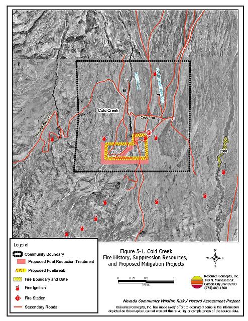
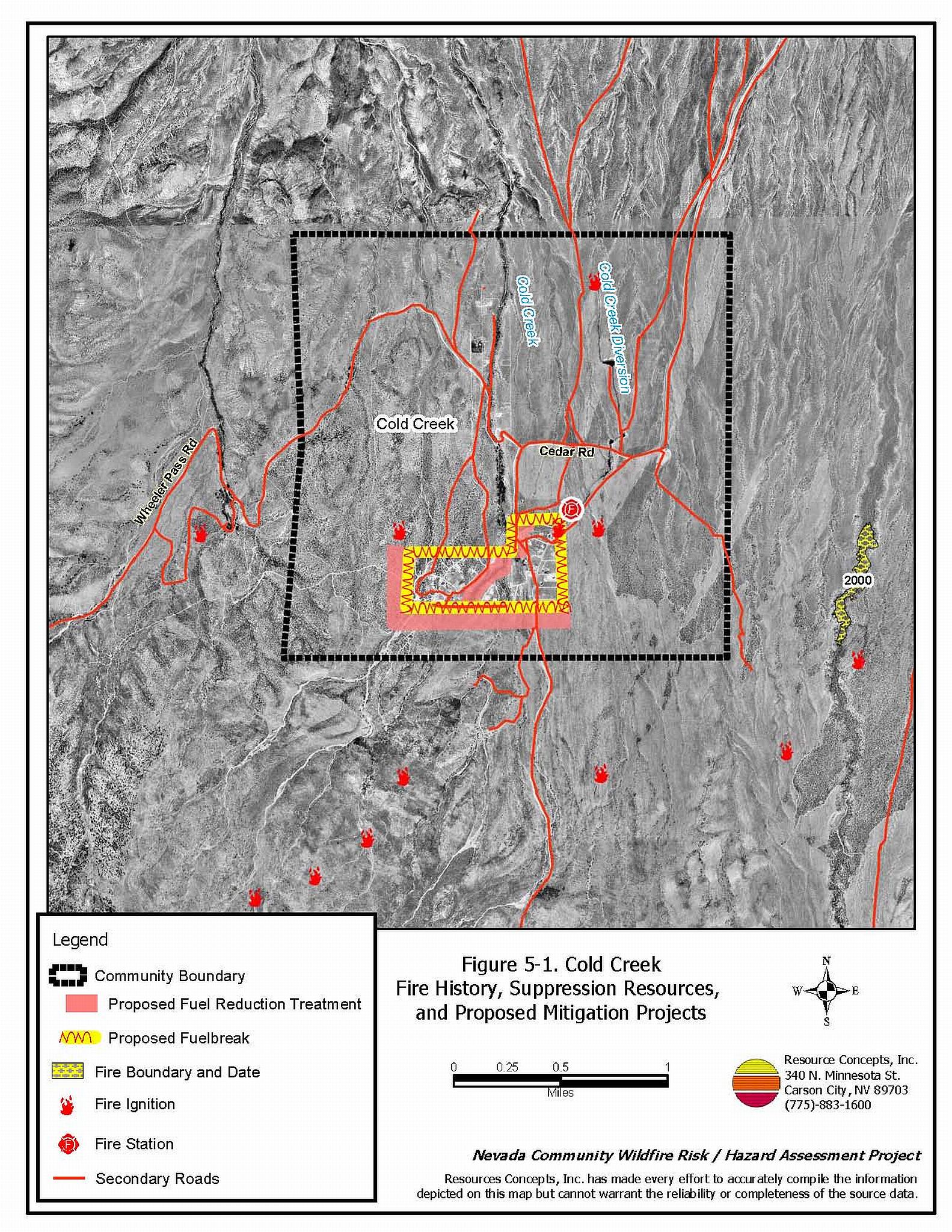
Details and locations for individual features are described below and shown in Figure 5-1.
Clark County
- Because of the limited access into and out of the community, it is imperative that flammable fuel loading is reduced along roadways. This will facilitate safe access to the community by fire suppression equipment, and it will improve evacuation safety out of the community. Mow or clear vegetation from a swath at least 25 feet wide or to the limit of the road right-of-way on both sides of the access road leading into Cold Creek and all community roadways. Reduce fuels to a height of not more than four inches. If necessary reseed according to recommendations in Appendix E to prevent noxious weed invasion. Maintain annually.
US Forest Service
- On the east and north sides of the community, create and maintain a 300-foot wide fuelbreak along the Forest Service / private property boundary. Remove all shrubs within fifteen feet of remaining tree canopies. Thin all other shrubs to a spacing equal to twice their height (canopy to canopy).
- On the west and south sides of the community, remove all trees within a 300-foot fuelbreak along the Forest Service / private property boundary. Reduce remaining shrubby vegetation to eighteen inches in height. Create a second or outer 300-foot wide fuelbreak in which trees and shrubs are thinned to a spacing equal to twice their height (canopy to canopy).
Cold Creek Community
- Thin vegetation for a distance of 200 feet along either side of the Cold Creek drainage where it runs through the community. Thin trees and shrubs to a spacing of two times their height (canopy to canopy).
5.2.3 Community Coordination
Many of the most effective activities aimed at reducing the threat of wildfire require that individual property owners coordinate with each other and with local fire authorities. The Cold Creek local chapter of the Nevada Fire Safe Council can facilitate coordination among homeowners and agencies. Defensible space, for example, is more effective in small communities when applied uniformly throughout entire neighborhoods. Public education and awareness, neighbors helping neighbors, and proactive individuals setting examples for others to follow are just some of the approaches that will be necessary to meet the fire safe goals in the community.
Clark County Fire Department
- Install a community siren to be used as an alarm call for evacuation.
Clark County
- Enforce or develop county laws, regulations, and ordinances that support implementation and maintenance of defensible space and address fuels reduction responsibilities for absentee homeowners and vacant lots.
Private Property Owners
- Ensure that address signs are visible from the road. Address characters should be at least four inches high, reflective, and composed of non-flammable material. Improving visibility of addresses will make it easier for those unfamiliar with the area to navigate under smoky conditions during a wildland fire.
- Work with the Clark County Fire Department and Sheriff’s Department to identify any non-ambulatory persons within the community who may need evacuation assistance in the event of an emergency.
5.2.4 Public Education
Clark County Fire Department
Public education focused on increasing community fire safety and the enforcement of defensible space is critical for the Cold Creek community. A program that explains fire safe measures in clear and emphatic terms will have an impact on residents in the wildland-urban interface. Informed community members will be more inclined to take actions to effectively reduce fuels and other wildfire hazards around their home and in their neighborhoods.
- Distribute copies of the publication “Living with Fire” to all property owners. This publication is free of charge. Copies can be requested from the University of Nevada Cooperative Extension.
- Contact the Nevada Division of Forestry, the Humboldt-Toiyabe National Forest, and University of Nevada Cooperative Extension for assistance with public education.
5.2.5 Fire Suppression Resources and Training
Clark County Fire Department
- Comply with minimum standards regarding training and personal protective equipment for all firefighters in accordance with the Wildland and Prescribed Fire Qualification System Guide PMS 310-1. (See Section 4.2 of this report for a description of these standards).
5.3 Summary of Recommendations
| Involved Party | Recommended Treatment |
Recommendation Description |
|---|---|---|
| Property Owners | Defensible Space | Remove, reduce, and replace vegetation around homes
according to the guidelines in Appendix E. Maintain defensible space as needed to keep the space lean, clean, and green. |
| Fuels Reduction | Thin vegetation along both sides of the Cold Creek drainage within the community. | |
| Community Coordination | Ensure that address signs are clearly visible from the
road. Identify non-ambulatory persons in need of assistance with evacuation. |
|
| Clark
County Fire Department Nevada Division of Forestry |
Defensible Space | Conduct courtesy inspections of defensible space condition and defensible space treatments on private property. |
| Clark County Fire Department | Community Coordination | Install a community siren to advise residents of evacuation orders. |
| Public Education | Distribute copies of “Living with Fire” to all
property owners living in Cold Creek. Contact NDF, the USFS, and the University of Nevada Cooperative Extension for assistance with public education activities. |
|
| Fire Suppression Resources and Training | Comply with NWCG 310-1 training and equipment standards. | |
| Clark County | Fuels Reduction | Reduce all vegetation to four inches on both sides of the main access road into Cold Creek. Mow or clear to 25 feet from the edge of pavement or to the limit of the road right-of-way corridor. |
| Community Coordination | Develop county ordinances that enforce the implementation and maintenance of defensible space. | |
| US Forest Service | Fuels Reduction | Create and maintain fuelbreaks at the perimeter of the community, along the Forest Service/private property boundary. |
Table 5-3Cold Creek Fire Hazard Ratings Summary |
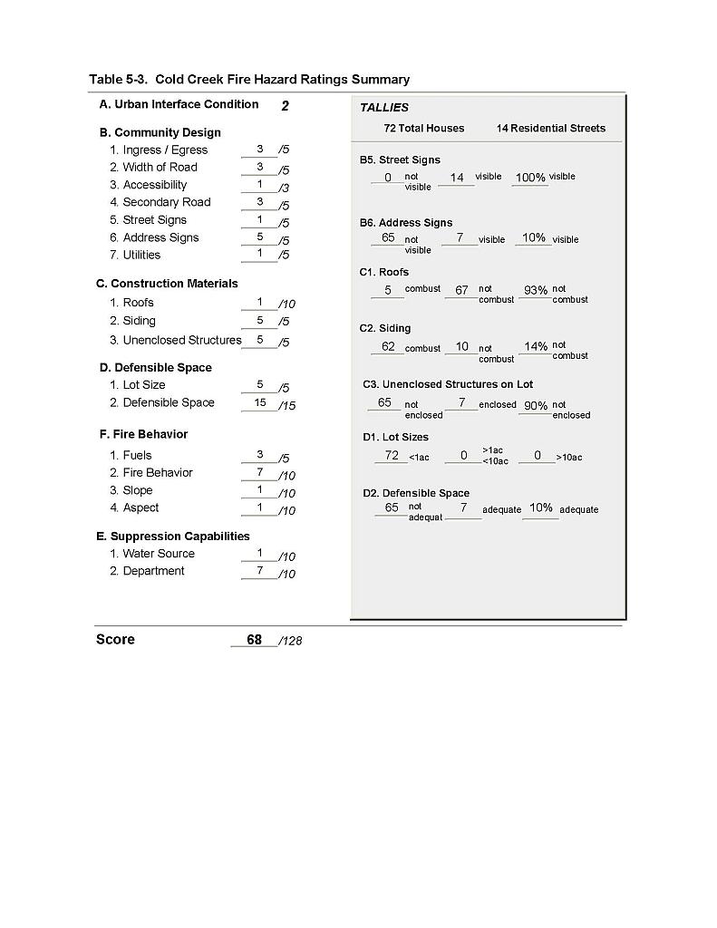 |
Figure 5-1Cold Creek Fire History, Suppression Resources, and Proposed Mitigation Projects |
 |
Figure 5-2Cold Creek Fuel Hazard Classification |
 |
Figure 5-3 Cold Creek Fuel Hazard Photo Points
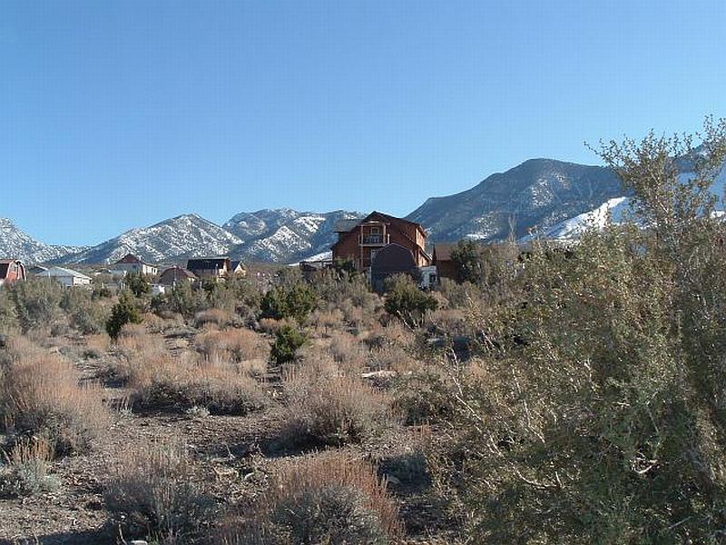
Photo Point 1. 4030698 N. 0613069 E, 166°SE. Heavy fuel loads, estimated at four to five tons per acre, consisting primarily of ephedra, cliffrose, and sagebrush surround residences. Pinyon encroachment into the interface increases the fuel hazard, which was considered extreme in this area.

Photo Point 2. 4030315 N, 613075 E. 192°SE. Vegetative fuels south of the community are composed of ephedra, cliffrose, and sage. Fuel loading was estimated at five tons per acre and was considered a high fuel hazard. This area is the site of a proposed fuel reduction treatment to slow the advance of a wildfire into the community.