![]()
![]()
7.0 Lee Canyon
7.1 Risk and Hazard Assessment
Lee Canyon is located on the east side of Mt. Charleston in the Spring Mountains, approximately forty miles northwest of Las Vegas. A total of 68 homes were observed during the community assessment in Lee Canyon. The assessment resulted in classifying Lee Canyon in the Extreme Hazard category (88 points). The rating is primarily attributed to limited access, poor defensible space, a high potential for extreme fire behavior, and structures without fire resistant building materials. The Mt. Charleston Ski Area is located at the top of Lee Canyon. Lee Canyon and the adjacent Kyle Canyon to the south are popular recreation areas in the summer and winter. Several thousand people visit the Lee and Kyle Canyon areas on a typical summer day (Grismanauskas, pers. comm.). Limited access is further constricted during the summer months as tourists park along the sides of the roads. Table 7-3 at the end of this section presents a summary of the community hazard rating values for Lee Canyon.
7.1.1 Community Design
The area surrounding Lee Canyon is characterized as an intermix interface condition. Structures are scattered throughout the wildland area and there is no clear line of demarcation between wildland fuels buildings and open space throughout the community. All lots are less than one acre in size. The community boundary is shown in Figure 7-1.
- Access: The primary access into Lee Canyon is State Route 156, a 20 to 24 foot wide paved two lane road that originates at US 95, sixteen miles down canyon. In places, the road gradient is greater than five percent. The base of the canyon may also be reached via State Route 158 from Kyle Canyon to the south. Secondary roads are mostly gravel and do not provide adequate room for fire suppression equipment to maneuver.
- Signage: Street signs are visible on all but one of the roads in the community. Residential addresses are visible on about ten percent of the homes in the community. Clear and visible street signs and residential addresses are important to aid firefighters in locating homes during low visibility conditions that commonly occur during wildland fires.
- Utilities: Utilities are a high ignition risk and have not been properly maintained around the Lee Canyon community. Power line corridors and transformer sites should be kept clear of flammable vegetation, as fires have been known to start from arcing power lines during windy conditions or from exploding transformers during peak electricity demand. Energized power lines can also fall during a wildfire creating additional hazards for citizens and firefighters.
7.1.2 Construction Materials
Approximately ninety percent of the homes in the interface are built with non-combustible roofing materials but only three percent of the homes have fire resistant siding materials. Most homes (ninety percent) in the community have unenclosed balconies, decks, porches, eaves, or attic vents that can create drafty areas where sparks and embers can be trapped, smolder, ignite, and rapidly spread fire to the house.
7.1.3 Defensible Space
The terrain in the Lee Canyon area is generally steep, with dense vegetation. None of the homes in the community meet the minimum requirements for defensible space landscaping in order to minimize property damage or loss of the home during a wildfire. Homes are situated on steep slopes, and in many cases tree branches are in direct contact with homes, overhanging roofs, or decks.
7.1.4 Suppression Capabilities
Wildfire Protection Resources
Improving defensible space around homes and reducing fuel loadings around residential clusters are essential precursors to ensuring that first-alarm (initial attack) firefighting resources are to most effectively protect homes and other resources.
Lee Canyon is included in the Nevada Division of Forestry 473 Fire Protection District for the Mt. Charleston area. A Nevada Division of Forestry fire station in Lee Canyon houses a Type 3 Brush Engine and is staffed with one career firefighter at all times. Additional resources for initial attack would come first from available resources in Kyle Canyon. Nearest suppression apparatus and human resources for initial attack Lee Canyon are summarized in Table 7-1. The numbers quoted below are based on data available at the time of interviews with local and regional fire authorities, and are subject to change.
| Type of Resource | Amount of Equipment | Cooperating Partner (Resource Location) |
|---|---|---|
| Type 3 Brush Engine | 1 | Nevada Division of Forestry (Lee Canyon Station) |
| Type 1 Structure Engine Type 6 Quick Attack Engine Basic Life Support (BLS) Rescue |
1 1 1 |
Clark County Rural Fire Station 81 (Kyle Canyon) |
| Type 3 Brush Engine Type 4 Brush Engine Type 7 Brush Patrol Engine |
1 1 1 |
US Forest Service (Kyle Station - seasonal) |
| Type 1 Structure Engine Type 3 Brush Engine |
1 1 |
Nevada Division of Forestry (Kyle Fire Station) |
| Source: Steve McClintock, Dave Bibee and Steve Brittingham, pers. comm., March 2004. | ||
Federal fire suppression resources such as those administered by the US Forest Service listed above are reported according to their local assigned area. It is important to note that these apparatus are considered national resources and are commonly reassigned to areas of higher severity during the fire season. In response to a wildland fire call, interagency dispatch centers locate and dispatch the closest available resource according to incident command and computer-aided dispatch protocols.
Water Sources and Infrastructure
There is no community water system or fire hydrants. Water availability for fire suppression in Lee Canyon includes community wells, and three 40,000-gallon storage tanks. The water system operates on gravity and pumps. Lee Canyon has emergency generators for back-up during power outages.
Fire Protection Personnel Qualifications
Volunteer and career firefighters who would respond to a wildfire near Lee Canyon have a minimum of NFPA firefighter I and II training and a limited number have had some wildland firefighting training (National Wildfire Coordinating Group 310-1). The Nevada Division of Forestry and US Forest Service personnel meet minimum requirements per NWCG 310-1.
Work Load
The Nevada Division of Forestry Fire Station responded to 200 emergency medical calls and 30 wildland brush fire calls in 2003. The Clark County Fire Department station responded to 37 emergency medical calls and eight wildland brush fire calls in 2003.
Detection and Communication
There are no fire lookouts in the Mt. Charleston area but reconnaissance flights do occur. Communications between Nevada Division of Forestry and the Clark County Fire Department are compatible and there are no gaps in radio coverage. There are no community sirens.
Financial Support
Funding for Clark County Fire Department annual operating expenses comes from the County General Fund, which is generated primarily through property taxes. Financial support for the Nevada Division of Forestry fire protection district comes from a contract with the Clark County Fire Department.
Community Preparedness
Clark County has an active Local Emergency Planning Committee and has adopted an all-risk, multi-agency emergency plan. The plan is reviewed annually and updated as needed.
Nevada Division of Forestry requests volunteer compliance with defensible space. The Nevada Division of Forestry has also participated in the implementation of a shaded fuelbreak in Lee Canyon and fuels reduction around the Clark County Fire Department fire station.
7.1.5 Factors Affecting Fire Behavior
The vegetative fuel density in the Lee Canyon area is light in the lower reaches and medium in the upper reaches with fuel loading at six to fifteen tons per acre. In lower Lee Canyon from US 95 to mile marker eight the vegetation is Mojave Desert scrub, transitioning into a blackbrush community. In mid Lee Canyon, slopes are up to ten to fifteen percent and the fuels consist of pinyon, juniper, and mountain mahogany. In upper Lee Canyon, where the majority of homes and buildings are concentrated, slopes are up to 65 percent and fuels consist of white fir, ponderosa pine, some pinyon juniper, mountain mahogany and Gambel’s oak. All aspects are found in the canyon but the majority of the structures are located on northeast facing slopes. There are continuous fuels in close proximity to structures and the fuels are conducive to crown fires, as ladder fuels are common.
This combination of factors creates conditions that warrant an extreme fuel hazard rating. The thick brush and trees intermixed with structures increase the potential for an extremely hazardous event.
7.1.6 Fire Behavior Worst-Case Scenario
The worst-case scenario would occur on a weekend summer day when parked cars along the roadway limit access and many people are in the area. In one scenario multiple ignitions due to a dry lightning storm above and west of the community on a summer weekend afternoon could result in a fast moving fire threatening structures. The fire could overwhelm initial attack resources and be driven by strong downslope winds.
In a second scenario, an ignition down slope of the community could have equally detrimental effects because of the natural chimney effect of Lee Canyon. Smoke plumes from a very large wildland fire can create unique weather conditions and wind. Wind caused by the fire can be stronger and from a different direction that the local gradient winds. A plume-dominated wildfire could rapidly move up the canyon into the community, blocking egress out of the community. In both scenarios, evacuations and response of firefighting resources may be compromised because there is only one road leading into and out of the community. The existing safe zone is not large enough to accommodate the number of people in the area on a weekend in the summer.
7.1.7 Ignition Risk Assessment
Lee Canyon was assigned a high ignition risk rating. Ignition history for the area shows numerous lightning strikes and other ignitions. The presence of campgrounds and the high level of visitor traffic during the dry summer season are also considerations for the high rating.
7.2 Risk and Hazard Reduction Recommendations
The Lee Canyon area is vulnerable to a catastrophic fire. Property owners need to take an active role in protecting their property by implementing fuels reduction treatments and defensible space treatments in their neighborhoods. The local chapter of the Nevada Fire Safe Council is an excellent means for organizing these activities. Clark County, the Nevada Division of Forestry, and the US Forest Service need to collaborate and implement fuelbreaks in strategic areas. Initial attack will be critical in any fire in the area and additional water resources need to be obtained for the initial attack.
7.2.1 Defensible Space
Vegetation density, type of fuel, and slope gradient around a home affect the potential fire exposure levels to the home. These conditions define the defensible space area required for individual homes. The goals of defensible space are to reduce the risk of property loss from wildfire by eliminating flammable vegetation near the home. In turn, this lowers the chances of a wildfire spreading onto adjacent properties and it aids firefighters in their efforts to protect property against an approaching wildfire. Guidelines for establishing and improving defensible space around residences and structures in the community are given below and described in greater detail in Appendix E.
Defensible space is especially important in Lee Canyon because homes and other structures are amidst heavy wildland vegetative fuels characterized as extreme fuel hazards. Defensible space is the homeowner’s responsibility, and it is an essential first line of defense for saving lives and property during a catastrophic wildland fire.
Private Property Owners
- Remove, reduce, and replace vegetation around homes according to the guidelines in Appendix E. Keep this area:
- Lean: There are only small amounts of flammable vegetation.
- Clean: There is no accumulation of dead vegetation or other flammable debris.
- Green: Existing plants are healthy and green during the fire season.
- Thin existing mature trees to maintain a minimum distance of thirty feet between tree crowns. Clear the area beneath retained trees of smaller trees, shrubs, duff, and other ladder fuels.
- Thin mountain mahogany, Gambel’s oak, and other shrubs and brush to a distance equal to twice their height.
- Prune and remove dead and diseased tree branches. For Ponderosa pine and white fir, prune branches a minimum of fifteen feet from the ground, but not more than one-third of the total tree height. For pinyon and juniper, prune all branches minimum of four feet from the ground, not to exceed one-third of the total tree height.
- Thin shrubs and other brush to a distance equal to twice their height (crown to crown).
- Clear brush, weeds, and grasses from within a ten-foot wide strip along either side of driveways.
- Enclose wooden decks and porches. Keep the area beneath wood decks and porches free of weeds and other flammable debris. Where possible, install screens around unenclosed overhangs.
- Clear vegetation and combustible materials from around propane tanks for a minimum of ten feet.
- Clear pine needles, leaves and debris from roofs and rain gutters.
- Store firewood a minimum of thirty feet from structures.
- Mow or remove brush growing against fences in the community.
- Ensure that all branches are at least fifteen feet from chimneys and other heat sources. Install spark arrestors or screens on fireplace and wood stove chimneys.
- Immediately remove all cleared vegetation to an approved disposal site. This material dries quickly and poses a fire risk if left on site.
- Where possible, irrigate trees and large shrubs that remain in close proximity to structures to increase their fire resiliency. This is especially important during drought conditions.
- Install screens over all exterior vents to prevent sparks from entering the attic and other areas inside the home.
- Replace all shake roofs and combustible siding with non-combustible materials to reduce the risk of ignition.
- Make sure residential addresses are visible from the road. Address characters should be at least four inches high and reflective. Improving visibility of addresses will make it easier for those unfamiliar with the area to navigate an area during a wildland fire.
- Maintain defensible space annually.
Clark County Fire Department and Nevada Division of Forestry
- Conduct courtesy inspections of home defensible space measures.
7.2.2 Fuel Reduction Treatments
Recommendations provided below focus on the reduction of fuels along county roadways and the development of fuelbreaks in key locations around the Lee Canyon community. A shaded fuelbreak is a fuels reduction treatment that alters the spacing and arrangement of combustible fuels in areas where the current fuel arrangement could support a catastrophic wildfire. If properly maintained, a shaded fuelbreak can eliminate the continuity of fuels in the tree, shrub, and ground layers. As a result, the heat intensity and rate of spread of an oncoming wildfire can be reduced considerably, offering conditions where a fire can be more safely and effectively managed on the ground.
Shaded Fuelbreak and Fuel Reduction Treatment Guidelines
The following specifications apply to fuel reduction treatments in this chapter.
- Broadcast seed treatment areas prior to fuel removal to enhance soil stabilization and the establishment of fire-resistant vegetation and to prevent noxious weed invasions. Use a pre-suppression seed mixture appropriate for the local climate and soil conditions, such as the one recommended in Appendix E.
- Thin mountain mahogany, pinyon, and juniper trees to a spacing equivalent to twice the height of the trees.
- Thin ponderosa pine and white fir trees to a minimum spacing of twenty to forty feet between tree trunks depending on the diameter of the tree, equivalent to 80 to 100 square feet of basal area per acre. (Refer to Appendix E for guidelines on basal area.) Thinning can be performed in a traditionally even-spaced manner, or trees can be thinned into a cluster-mosaic at the direction of a professional forester.
- Thin trees from below - remove smaller ponderosa pine, Gambel’s oak, pinyon pine, and mountain mahogany from under old growth ponderosa pine.
- The Nevada Forest Practice Act restricts the use of heavy equipment on slopes greater than thirty percent. Consult with a professional forester form the Nevada Division of Forestry for technical assistance with marking trees for removal, permitting and special operations on steep slopes.
- Where trees are removed, cut stumps as close to the ground as possible, leaving no stump higher than four inches.
- For mature large conifers such as ponderosa pine and white fir, prune all branches from six to fifteen feet above the ground, but not more than one-third of the total tree height. For smaller conifers such as pinyon and juniper trees, limb all branches a minimum of four feet from the ground, not to exceed one-third of the total tree height.
- Prune and remove dead and diseased tree branches
- Keep the area within ten feet of pruned trees free of smaller trees, shrubs, duff, and other ladder fuels.
- Thin areas of dense brush to a spacing between shrub canopies equal to twice the shrub height. Further reduce the fuel volume by reducing shrubs to a height of eighteen inches or less.
- Maintain fuel reduction treatment areas by limiting regrowth and reinvasion of woody species.
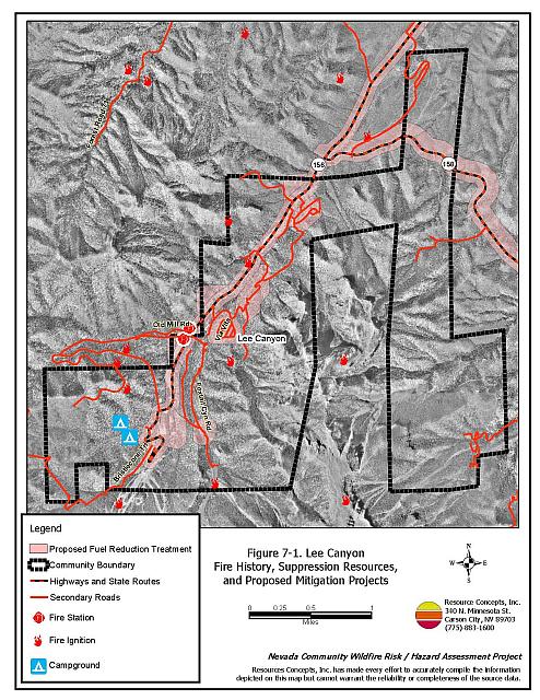
Recommended locations of fuel treatment projects are discussed below and illustrated in Figure 7-1.
Property Owners
- Coordinate with the Mt. Charleston Chapter of the Nevada Fire Safe Council to implement and maintain a shaded fuelbreak throughout all of the housing clusters in Lee Canyon.
Clark County, Clark County Fire Department, and Nevada Division of Forestry
- Construct and maintain a shaded fuelbreak within a 600-foot wide buffer around all of the housing clusters in Lee Canyon.
- Implement and maintain a shaded fuelbreak from mile marker eight west to the junction of State Route 156 and State Route 158. The fuelbreak will measure 300 feet wide on both sides of the road.
- Implement and maintain a shaded fuelbreak on both sides of State Route 156 from the junction with State Route 158 to the ski area. The fuelbreak will measure 300 feet wide on the uphill side of the road and 600 feet wide on the downhill side of the road.
- Construct and maintain a shaded fuelbreak for a distance of 300 feet around the McWilliams and Dolomite Campgrounds. Reduce vegetation within these and all other concentrated public-use areas consistent with shaded fuelbreak guidelines.
Utility Company
- Remove entire trees under utilities instead of topping them for power line clearance. Topping trees severely weakens them and predisposes them to attack by bark beetles. The fir engraver (Scolytus ventralis) is causing significant mortality in white fir.
- Completely remove all vegetation within 15 feet of utility poles to prevent structural failure during a wildfire.
- Clear all vegetation surrounding electrical transfer stations within thirty feet of the fence. For a distance of 300 feet, thin trees to a spacing equivalent to twice the height of the trees from crown to crown.
7.2.3 Community Coordination
Clark County Fire Department, Nevada Division of Forestry, and the US Forest Service
Coordination among local, state and federal fire suppression agencies is important in the day-to-day fire prevention activities and becomes critical in the event of a wildland fire. The general goal of community coordination is to make the entire community fire safe. In Lee Canyon, community coordination is needed so people will know what to do in the event of a wildfire in the canyon.
- Develop an evacuation plan. Provide the plan to all homeowners and post copies in public places. Include in the plan locations of non-ambulatory persons within the community who may need evacuation assistance.
- Install a community siren as a communication tool for evacuation.
- Install water tanks with a minimum storage capacity of 1,000 gallons for structure protection.
- Investigate the purchase of a fire blocking gel or foam that can be applied to structures and to vegetation in order to create an additional layer of fire protection.
- Post “No Parking” signs and enforce limited parking along roadways in areas where roadside parking would restrict emergency access.
- Identify or develop fire safe zones and fire safe structures for people to use if they are trapped in the canyon during a wildfire. These areas could include the fire stations, the library, the school, and a cleared area directly above the community (at least two acres in size). Limit the number of people (residents and tourists) in the canyon on high hazard days according to the capacity of the safety zones (use the estimated capacity of all identified fire safe zones and structures to determine the total number of people allowed in the canyon on a given summer day). Use the Fire Marshall’s building capacity when estimating the number of people allowed in structures identified as fire safe.
US Forest Service
- Establish and designate safe zones so that people have a place to go if they become trapped in the canyon and must shelter in place during a wildland fire incident.
Clark County
- Ensure cooperation between the Assessor’s office and the roads department to ensure that all new development roads are named, mapped, and identified with GPS locations.
- Create turnarounds with a minimum radius of seventy feet and adequate clearance on either side of access roads for large fire engines and other fire apparatus.
Property Owners
- Work with the Clark County Fire Department and Sheriff’s Department to identify any non-ambulatory persons within the community who may need evacuation assistance in the event of an emergency.
7.2.4 Public Education
Public education is an important tool to engage public participation in making a community fire safe. Informed community members will take the initiative required to lead efforts of a scale sufficient to effectively reduce the threat that wildland fires present to the entire interface community.
Clark County Fire Department, US Forest Service, and Nevada Division of Forestry
- Distribute copies of the publication “Living with Fire” to all property owners. This publication is free of charge. Copies can be requested from the University of Nevada Cooperative Extension.
- Hold an annual community fire awareness event.
7.2.5 Fire Suppression Resources and Training
Clark County Fire Department
- Comply with minimum standards regarding training and personal protective equipment for all firefighters in accordance with the Wildland and Prescribed Fire Qualification System Guide PMS 310-1. (See Section 4.2 of this report for a description of these standards).
- Using wells, existing springs, ponds, tanks, etc. identify and develop a helicopter dip site for use during initial attack, especially for use during the summer months. Incorporate this information in to a pre-attack plan that is updated annually.
- Install water tanks with a minimum storage capacity of 1,000 gallons for structure protection.
Clark County
- Improve water storage capacity and install hydrants or standpipes in subdivisions.
Property Owners
- Investigate the purchase of a fire blocking gel or foam that can be applied to structures and to vegetation in order to create an additional layer of fire protection.
7.3 Summary of Recommendations
| Involved Party | Recommended Treatment | Recommendation Description |
|---|---|---|
|
Property Owners Clark County |
Defensible Space | Apply and maintain aggressive defensible space treatments according to the guidelines in Appendix E. Replace all shake roofs and combustible siding with non-combustible materials. |
| Community Coordination | Ensure that address signs are clearly visible from the road. Identify non-ambulatory persons in need of assistance with evacuation. |
|
| Fire Suppression Resources and Training | Investigate the purchase and use of fire blocking foams and gels for individual property protection in the wildland-urban interface. | |
| Fuels Reduction | Coordinate with the local Fire Safe Chapter to implement and maintain shaded fuelbreaks throughout all housing clusters in Lee Canyon. | |
|
Clark County Fire Department Nevada Division of Forestry US Forest Service |
Defensible Space | Conduct courtesy inspections of defensible space condition and defensible space treatments on private property. |
| Fuels Reduction | Construct and maintain shaded fuelbreaks:
|
|
| Public Education | Distribute copies of “Living with Fire” to all property owners living in Lee Canyon. Hold annual community fire awareness event. Contact NDF, the USFS, and the University of Nevada Cooperative Extension for assistance with public education activities. |
|
| Community Coordination | Prepare an emergency evacuation plan for Lee Canyon. Distribute copies of this plan to homeowners in the area and post versions of the plan in public places. Identify and develop fire safe zones and sheltering structures. Limit the number of visitors in the area to the capacity of these safe zones. Install a community siren to advise residents and visitors of evacuation orders. Develop a helicopter dip site using wells, existing springs, ponds, and tanks. |
|
| Clark County Fire Department | Fire Suppression Resources and Training | Comply with NWCG 310-1 training and equipment standards. Evaluate the use of fire blocking foams and gels for individual building protection in the wildland-urban interface. Improve water storage capacity and install hydrants or standpipes in subdivisions. |
| Clark County | Community Coordination | Ensure cooperation between the Assessor’s Office and the Roads Department so that all roads in new developments are named, signed, mapped, and identified with GPS locations. Develop county ordinances that enforce the implementation and maintenance of defensible space. |
| Utility Company | Fuels Reduction | Remove trees within overhead utilities corridors; completely remove all vegetation within fifteen feet of utility poles. Clear all vegetation surrounding electrical transfer stations in Lee Canyon. |
Table 7-3. Lee Canyon Fire Hazard Ratings Summary |
 |
Figure 7-1 Lee Canyon Fire History, Suppression Resources, and Proposed Mitigation Projects |
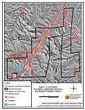 |
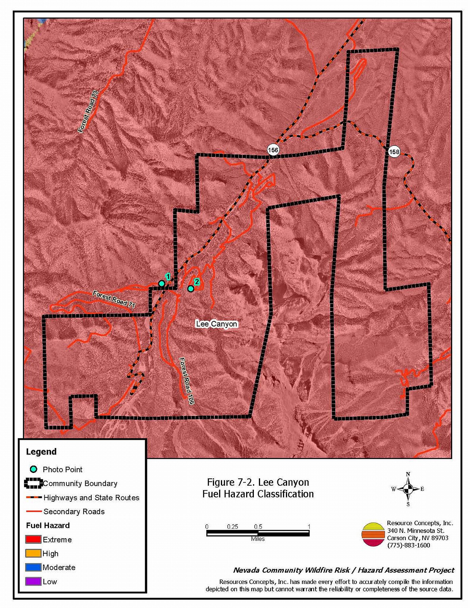
Figure 7-2 Lee Canyon Fuel Hazard Classification |
 |
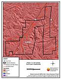
Figure 7-3 Lee Canyon Fuel Hazard Photo Points

Photo Point 1. 4020301 N. 0619088 E. Direction 135°SE. Overstocked stands of ponderosa pine have established in the absence of understory thinning activities or low-intensity ground fires. The proposed fuel reduction treatment for this area is to thin trees to a spacing of twenty to forty feet between tree trunks, depending upon tree diameter, to achieve a basal area of 80 to 100 square feet per acre. A professional forester should be consulted for tree marking prior to removal.

Photo Point 2. 4020222 N. 0619545 E. Direction 285°WNW. Inadequate defensible space is very common in Lee Canyon. Fuel reduction treatments are recommended for the Via Vita neighborhood and others in Lee Canyon.