![]()
![]()
9.0 Nelson
9.1 Risk and Hazard Assessment
Nelson is located in the upper reaches of El Dorado Canyon near the Colorado River, approximately forty miles southeast of Las Vegas. Forty homes in the Nelson area were assessed. This assessment resulted in classifying Nelson in the High Hazard category (seventy points). The rating is primarily attributed to limited access in and out of the community, poor defensible space, and limited fire protection resources. Table 9-3 at the end of this section presents a summary of the community hazard rating values for Nelson.
9.1.1 Community Design
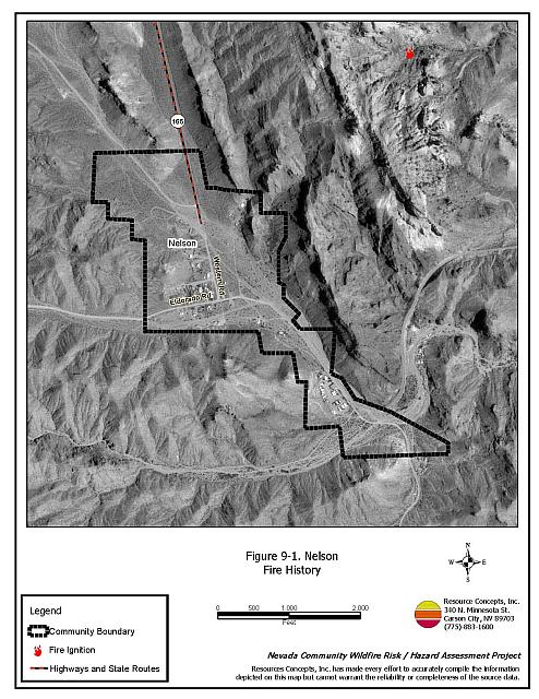
The area surrounding Nelson is characterized by an intermix wildland-urban interface condition: structures are scattered throughout the wildland area with no clear line of demarcation between wildland fuels, buildings, and open space throughout the community. The majority of the lots are less than one acre in size. The community boundary is shown in Figure 9-1.
- Access: Primary access into Nelson is via State Route 165, a paved two-lane road that is greater than 24 feet in width and has a gradient of less than five percent. This is the only access road in and out of the community. The majority of the secondary roads provide adequate turnaround space for fire suppression equipment to maneuver.
- Signage: Street signs are visible on all of the roads in the community. Residential addresses are visible on all of the homes in the community. Clear and visible street signs and residential addresses are important to aid firefighters in locating homes during low visibility conditions that occur during a wildland fire.
- Utilities: Power lines have not been properly maintained. Power line corridors and transformer sites should be kept clear of flammable vegetation, as fires have been known to start from arcing power lines during windy conditions. Fire damage to power lines often creates power failures that can be especially dangerous in communities without a backup energy source. Energized power lines can also fall during a wildfire creating additional hazards for citizens and firefighters.
9.1.2 Construction Materials
All of the homes in the interface are built with non-combustible roofing materials and all but one of the homes has fire resistant siding materials. Approximately one-third of the homes in the community (36 percent) have unenclosed balconies, decks, porches, eaves, or attic vents that can create drafty areas where sparks and embers can be trapped, smolder, ignite, and rapidly spread fire to the house.
9.1.3 Defensible Space
Approximately ten percent of the homes in Nelson have landscaping that meets the minimum requirement for defensible space in order to minimize property damage or loss of the home during a wildfire.
9.1.4 Suppression Capabilities
Wildfire Protection Resources
Nelson has no organized fire department. The nearest trained fire responders are municipal resources located in Boulder City, approximately 25 miles to the north.
| Type of Resource | Amount of Equipment | Cooperating Partner (Resource Location) |
|---|---|---|
| Type 1 Structure Engine Advanced Life Support (ALS) Rescue |
1 1 |
Boulder City Fire Department (Boulder City) |
| Type 3 Brush Engine Type 6 Brush Patrol Engine |
1 1 |
National Park Service (Boulder City) |
| Type 1 Structure Engine Type 6 Quick Attack Engine Basic Life Support (BLS) Rescue |
2 2 1 |
Clark County Fire Department (Nearest Resource) |
| Source: Steve McClintock, Kurt Leavitt, Mark Blankensop, pers. comm. March 2004. K. Oliver, pers. comm. 12 Oct 2004 | ||
In the event of a wildfire in the Nelson area, County resources would be dispatched through the Clark County Fire Alarm Office. Federal resources are dispatched through the Las Vegas Interagency Communications Center. State resources are dispatched through the Sierra Front Interagency Dispatch in Minden, Nevada. These systems locate the nearest available fire suppression resource according to incident command and computer aided dispatch protocols. Suppression resources administered by federal agencies such as the US Forest Service and the Bureau of Land Management are considered national resources and are commonly reassigned to areas of higher severity during the fire season.
Water Sources and Infrastructure
Water availability for fire suppression in Nelson includes community wells.
Fire Protection Personnel Qualifications
There are no trained firefighters in the Nelson area. The closest stations are approximately 25 miles to the north in Boulder City or Henderson.
Detection and Communication
There are no formal fire detection and communication tools available other than 911. There are no community sirens.
Community Preparedness
Clark County has an active Local Emergency Planning Committee and has adopted an all-risk, multi-agency emergency plan. The plan is reviewed annually and updated as needed.
9.1.5 Factors Affecting Fire Behavior
The vegetative fuel density in the Nelson area is generally moderate within the town itself and low outside of the community. Ground fuels consist of annual grasses. The shrub layer is dominated by bursage (one to three feet tall) and creosote bush (four to six feet tall). Some trees are planted near structures. The fuel hazard rating for Nelson is reported as Low to Moderate.
Slopes reach up to ten percent within the community, which is situated in a long narrow canyon. Strong winds funneled up and down through the canyon can contribute to erratic fire behavior making suppression and control of wildfire more difficult.
9.1.6 Fire Behavior Worst-Case Scenario
The worst-case scenario for the community of Nelson and the old mining store would be an ignition that started down canyon (east) from the community with strong upslope winds pushing the fire toward the community. In a wet year, dried grasses and annual plants would provide a receptive fuel bed for ignition. Under strong winds, a fire could be pushed through the bursage/creosote bush fuels. Structures that are intermixed throughout the interface contribute to the hazard. Firebrands could ignite structure fires within the community. Because resources are one hour away, several structures could be lost before fire suppression assistance is provided.
9.1.7 Ignition Risk Assessment
Nelson has a moderate ignition risk rating. Dried annual grasses and forbs create a fuel bed receptive for ignitions.
9.2 Risk and Hazard Reduction Recommendations
The Nelson area is vulnerable to a large fire. Property owners need to take an active role in protecting their property by implementing defensible space treatments, and agencies need to conduct fuels reduction projects. Defensible space is especially important in the Nelson area because it is vulnerable to a large fire. Defensible space is the homeowner’s responsibility, and it is an essential first line of defense for saving lives and property during a catastrophic wildland fire.
9.2.1 Defensible Space
Vegetation density, type of fuel, and slope gradient around a home affect the potential fire exposure levels to the home. These conditions define the defensible space area required for individual homes. The goals of defensible space are to reduce the risk of property loss from wildfire by eliminating flammable vegetation near the home. In turn, this lowers the chances of a wildfire spreading onto adjacent properties and it aids firefighters in their efforts to protect property against an approaching wildfire. Guidelines for establishing and improving defensible space around residences and structures in the community are given below and described in greater detail in Appendix E.
Private Property Owners
- Remove, reduce, and replace vegetation around homes. Keep this area:
- Lean: There are only small amounts of flammable vegetation.
- Clean: There is no accumulation of dead vegetation or other flammable debris.
- Green: Existing plants are healthy and green during the fire season.
- For deciduous and coniferous trees within the defensible space zone, limb branches a minimum of four feet from the ground. Remove all dead and diseased branches and duff from beneath remaining trees to reduce ladder fuels.
- Thin shrubs and other brush to a distance equal to twice their height (crown to crown).
- Mow or cut grass to a maximum height of four inches.
- Clear brush, weeds, and grasses from within a ten-foot wide strip along either side of driveways.
- Clear vegetation and combustible materials from around propane tanks for a minimum of ten feet.
- Immediately remove all cleared vegetation to an approved disposal site. This material dries quickly and poses a fire risk if left on site.
- Enclose wood decks and porches. If this is not possible, maintain these areas free of weeds and other flammable debris. Where possible, install screens around unenclosed overhangs.
- Ensure that residential addresses are visible from the road. Address characters should be at least four inches high and reflective. Improving visibility of addresses will make it easier for those unfamiliar with the area to navigate during a wildland fire.
- Install screens over all exterior vents to prevent sparks from entering the attic and other areas inside the home.
- Ensure that all branches are at least fifteen feet from chimneys and other heat sources. Install spark arrestors or screens on fireplace and wood stove chimneys.
- Maintain defensible space annually.
Clark County Fire Department and Nevada Division of Forestry
- Conduct courtesy inspections of home defensible space measures.
9.2.2 Community Coordination
Coordination among local, state, and federal fire suppression agencies is important in the day-to-day fire prevention activities and becomes critical in the event of a wildland fire. The goal of community coordination is to make the entire community fire safe.
Private Property Owners
- Remove abandoned or boarded up trailers.
- Work with the Clark County Fire Department and the Sheriff’s Department to identify any non-ambulatory persons within the community who may need evacuation assistance in the event of an emergency.
- Form a local chapter of the Nevada Fire Safe Council. The Nevada Fire Safe Council facilitates solutions to reduce the loss of lives and property from the threat of wildfire in Nevada’s communities. Through the establishment of a local Chapter, communities will become part of a large network for sharing information and notification of programs and funding opportunities for fire mitigation projects such as those listed in this report. The Nevada Fire Safe Council will accept and manage grants and contracts on the Chapter’s behalf through its non-profit status. The Nevada Fire Safe Council will provide assistance and support to communities to complete fire safe plans, set priorities, educate and train community members, and promote success stories of its members. To form a local Chapter or for more information contact the:
Nevada Fire Safe Council
1187 Charles Drive
Reno, Nevada 89509
www.nvfsc.org
Clark County
- Form a volunteer Clark County Fire Department for coordinating training, equipment, and seasonal personnel for fire suppression in the community.
- Encourage cooperation between the Assessor’s Office and the Roads Department to ensure that all new development roads are named, mapped, and identified with GPS locations.
- Pursue grant funding and station a pick-up truck and a one-piece, slip-on, 100 to 200-gallon tank and pump unit with hose and hose reel in Nelson during the fire season. This equipment, fitted properly for the size and weight limitations of the truck, can be used to provide initial attack of small ignitions.
9.2.3 Fuels Reduction
Utility Company
- Clear vegetation within thirty feet of the fence surrounding electrical transfer stations.
- Remove all trees from beneath transmission lines. Trim brush to eighteen inches tall and thin to a distance two times shrub height.
9.2.4 Public Education
Public education is an important tool to engage public participation in making a community fire safe. Informed community members will take the initiative required to lead efforts of a scale sufficient to effectively reduce the threat that wildland fires present to the entire interface community.
Clark County Fire Department
- Distribute copies of the publication “Living with Fire” to all property owners. This publication is free of charge. Copies can be requested from the University of Nevada Cooperative Extension.
9.3 Summary of Recommendations
| Involved Party | Recommended Treatment | Recommendation Description |
|---|---|---|
| Property Owners | Defensible Space | Remove, reduce, and replace vegetation around homes according to the guidelines in Appendix E. Maintain defensible space as needed to keep the space lean, clean, and green. |
| Community Coordination | Form a local chapter of the Nevada Fire Safe Council. Remove boarded up and abandoned trailers. |
|
| Clark County Fire Department | Defensible Space | Conduct courtesy inspections of defensible space condition and defensible space treatments on private property. |
| Public Education | Distribute copies of “Living with Fire” to all property owners living in Nelson. | |
| Clark County | Community Coordination | Authorize the formation of a Clark County Volunteer Fire Department in Nelson for coordinating recruitment, training, and equipping of local volunteers. Station a pick-up truck with a tank, pump unit, and hose reel in Nelson during the fire season. Ensure cooperation between the Assessor’s Office and the Roads Department so that all roads in new developments are named, signed, mapped, and identified with GPS locations. |
| Utility Company | Fuels Reduction | Clear vegetation within thirty feet of the fence surrounding the electrical transfer station. Remove trees and trim shrubs within overhead utilities corridors; completely remove all vegetation within fifteen feet of utility poles. |
Table 9-3. Nelson Fire Hazard Ratings Summary |
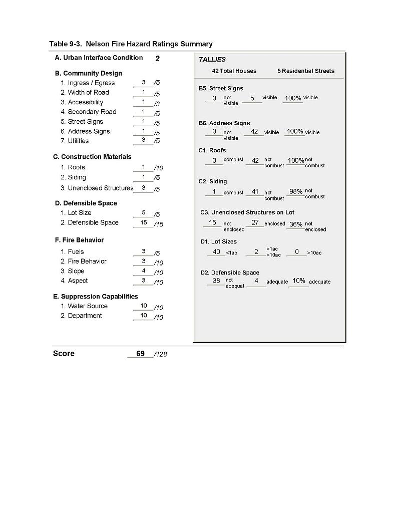 |
Figure 9-1 Nelson Fire History |
 |