![]()
![]()
10.0 Torino Ranch
10.1 Risk and Hazard Assessment
Torino Ranch is located along the west side of the Spring Mountains at approximately 5,800 feet in elevation. The community is approximately eight miles west of Mt. Springs on Highway 160 and three miles north of Highway 160. There are approximately thirty structures in the Torino Ranch area. The ranch is used to provide summer camp opportunities for children. The assessment resulted in classifying Torino Ranch in the High Hazard category (67 points). The rating is primarily attributed to limited access, the potential for extreme fire behavior, and the absence of formally organized fire suppression resources. Table 10-3 at the end of this section presents a summary of the community hazard rating for Torino Ranch.
10.1.1 Community Design
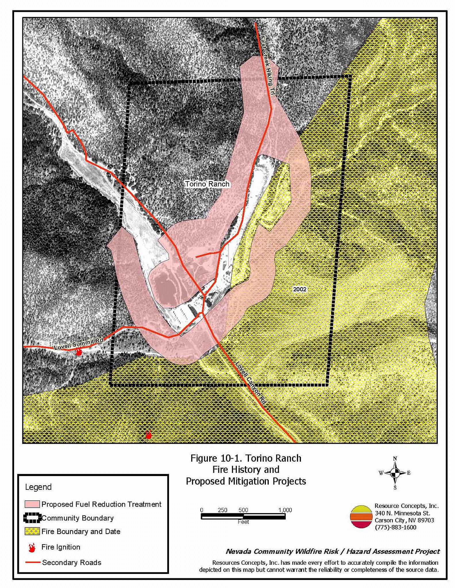
The area surrounding Torino Ranch is characterized as a classic interface condition, with a clear line of demarcation where buildings abut wildland fuels. Wildland vegetation typically does not continue into developed areas where ranch buildings are clustered. The community boundary is shown in Figure 10-1.
- Access: The primary access into Torino Ranch is Lovell Canyon Road, a two-lane paved road that is between 20 and 24 feet wide. This is the only access road in and out of the ranch. The road is approximately three miles long and intersects with Highway 160 approximately eight miles west of Mt. Springs. The road gradient is steeper than five percent in places. Many of the secondary roads are dead-end streets and do not have adequate turnaround space for fire suppression equipment to maneuver.
- Signage: Because the area is a ranch, there are no street signs or building numbers.
- Utilities: Power lines and propane tanks in the Torino Ranch area have been maintained and generally pose a low ignition risk.
10.1.2 Construction Materials
Almost all of the structures (93 percent) in the interface are built with non-combustible roofing materials and fire resistant siding materials. None of the structures have unenclosed balconies, decks, porches, eaves, or attic vents that can create drafty areas where sparks and embers can be trapped, smolder, ignite, and rapidly spread fire to the house.
10.1.3 Defensible Space
The Torino Ranch meets the defensible space landscaping requirement to minimize damage to the home or loss during a wildfire.
10.1.4 Suppression Capabilities
Wildfire Protection Resources
The nearest fire suppression resources for this area are the county and federal resources assigned to Mt. Springs, over twenty miles away, or those located in Pahrump in neighboring Nye County, nearly forty miles away.
| Type of Resource | Amount of Equipment | Cooperating Partner (Resource Location) |
|---|---|---|
| (No formal local resources) | Torino Ranch | |
| Type 1 Structure Engine Water Tender Type 6 Quick Attack Engine |
1 1 1 |
Clark County Rural Fire Station 79 (Mountain Springs) |
| Type 3 Brush Engine Type 7 Brush Patrol Engine |
2 1 |
US Forest Service (Station 79, Mountain Springs) |
| Type 3 Brush Engine Type 1 Structure Engine Water Tender |
1 1 1 |
Pahrump Fire Department (Pahrump) |
| Type 4 Brush Engine | 1 | Bureau of Land Management (Pahrump) |
| Type 4 Brush Engine | 1 | US Forest Service (Pahrump) |
In the event of a wildfire in the Torino Ranch area, County resources would be dispatched through the Clark County Fire Alarm office. Federal resources are dispatched through the Las Vegas Interagency Communications Center. These systems locate the nearest available fire suppression resource according to incident command and computer aided dispatch protocols. Suppression resources administered by federal agencies such as the US Forest Service and the Bureau of Land Management are considered national resources and are commonly reassigned to areas of higher severity during the fire season.
Water Sources and Infrastructure
Torino Ranch has a large pond, a pool, and a water tank. The pond is large enough for a helicopter dip site and to draft water for fire suppression. Water sources from Mt. Springs would require 45 minutes or more round trip.
Detection and Communication
There are no fire lookouts in the Torino Ranch area but the area is included in the reconnaissance flights conducted for the Spring Mountains. There are no community sirens.
Community Preparedness
Clark County has an active Local Emergency Planning Committee and has adopted an all-risk, multi-agency emergency plan. The plan is reviewed annually and updated as needed.
10.1.5 Factors Affecting Fire Behavior
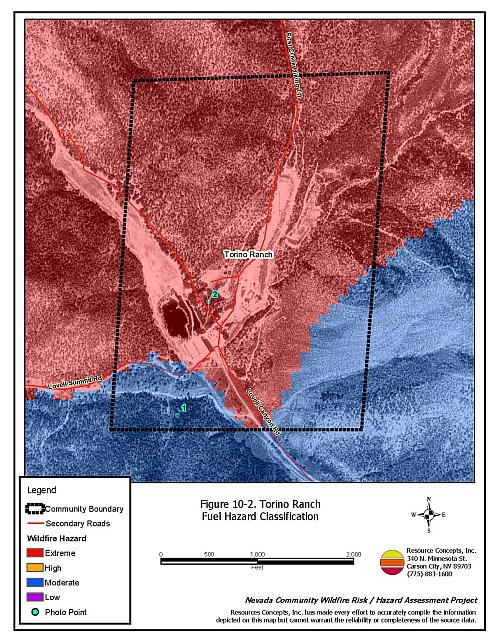
The 2001 Lost Cabin Fire burned around Torino Ranch on two sides. The vegetative fuel density in the unburned areas is generally heavy. Ground fuels consist of annual grasses. The shrub layer is dominated by bursage (four feet tall), rabbit brush (six feet tall), ephedra (four feet tall), and manzanita (four foot tall). The tree layer is dominated by pinyon and juniper, both reaching twenty feet in height. These factors combine to give the Torino Ranch an extreme fuel hazard rating.
The ranch is situated in a major southwest to northeast drainage on the west side of the Spring Mountains. The narrow canyon could act as a chimney resulting in strong winds during a fire. These topographic influences can intensify fire behavior.
10.1.6 Fire Behavior Worst-Case Scenario
The worst-case scenario would occur on a summer afternoon during normal working hours when many volunteer firefighters in Mt. Springs may not be immediately available. A fire resulting from a dry lightning storm with multiple ignitions south of the ranch could block the road and prevent people from evacuating and suppression equipment from entering the area. A fire could be pushed through the heavy fuels into the ranch structures. Initial attack resources must travel thirty to forty minutes to reach the ranch. A fire could easily escape initial attack efforts.
10.1.7 Ignition Risk Assessment
Torino Ranch has a high ignition risk rating. In wet years, high volumes of dried annual grasses and forbs provide a receptive fuel bed for any ignition. The structures intermixed throughout the area contribute to the hazard.
10.2 Risk and Hazard Reduction Recommendations
If an ignition starts, the Torino Ranch area is vulnerable to a catastrophic fire due to the remote location of the ranch. Recommendations to mitigate hazards focus on expanding defensible space areas, developing a fire safe area in the event of a fire, and expanding firefighting capabilities in the area.
10.2.1 Defensible Space
Vegetation density, type of fuel, and slope gradient around a home affect the potential fire exposure levels to the home. These conditions define the defensible space area required for individual homes. The goals of defensible space are to reduce the risk of property loss from wildfire by eliminating flammable vegetation near the home. In turn, this lowers the chances of a wildfire spreading onto adjacent properties and it aids firefighters in their efforts to protect property against an approaching wildfire. Guidelines for establishing and improving defensible space around residences and structures in the community are given below and described in greater detail in Appendix E.
Private Property Owners
- Remove, reduce, and replace vegetation around homes. Keep this area:
- Lean: There are only small amounts of flammable vegetation.
- Clean: There is no accumulation of dead vegetation or other flammable debris.
- Green: Existing plants are healthy and green during the fire season.
- Prune and remove dead and diseased tree branches. For pinyon and juniper trees, prune all branches a minimum of four feet from the ground, not to exceed one-third of the total tree height.
- Remove all duff, shrubs, and other ladder fuels from beneath the crowns of limbed trees to a distance of ten feet from the drip line of the tree crown.
- Thin shrubs and other brush to a distance equal to twice their height (crown to crown).
- Control annual grasses and weeds by mowing or by treating weedy areas with pre-emergent herbicides to prevent their seeds from germinating.
- Cut grass and weeds for a distance of twenty feet on either side of all driveways.
- Clear all vegetation and combustible materials from around propane tanks for a minimum distance of ten feet, or twice the height of pinyon and juniper trees, whichever is the greater distance.
- Remove other debris and flammable materials.
- Clear pine needles, leaves, and debris from roofs and rain gutters.
- Immediately remove all cleared vegetation to an approved disposal site. This material dries quickly and poses a fire risk if left on site.
- Establish defensible space around bunkhouses and outbuildings.
- Enclose wood decks and porches. If this is not possible, keep the area beneath wood decks and porches free of weeds and other flammable debris. Where possible, install screens around unenclosed overhangs.
- Install screens over all exterior vents to prevent sparks from entering the attic and other areas inside the home.
- Maintain defensible space annually.
Clark County Fire Department
- Conduct courtesy inspections of ranch defensible space measures.
10.2.2 Fuel Reduction Treatments
Recommendations provided below focus on the reduction of fuels along county roadways and the development of fuelbreaks in key locations around the Torino Ranch community. A shaded fuelbreak is a fuels reduction treatment that alters the spacing and arrangement of combustible fuels in areas where the current fuel arrangement could support a catastrophic wildfire. If properly maintained, a shaded fuelbreak can eliminate the continuity of fuels in the tree, shrub, and ground layers. As a result, the heat intensity and rate of spread of an oncoming wildfire can be reduced considerably, offering conditions where a fire can be more safely and effectively managed on the ground.
Shaded Fuelbreak and Fuel Reduction Treatment Guidelines
The following specifications apply to fuel reduction treatments in this chapter.
- Broadcast seed in fuelbreak areas prior to fuel removal to enhance soil stabilization and the establishment of fire-resistant vegetation and to prevent noxious weed invasions. Use a pre-suppression seed mixture appropriate for the local climate and soil conditions, such as the one recommended in Appendix E.
- Thin trees to a spacing equivalent to two times the height of the trees. The Nevada Forest Practice Act restricts the use of heavy equipment on slopes greater than thirty percent. Consult with a forester from the Nevada Division of Forestry for technical guidance about permitting and carrying out thinning operations on steep slopes.
- If a traditional, even-spaced thinning is not desired, it is permissible to thin trees in a cluster-mosaic formation laid out by a forestry professional.
- Limb tree branches on pinyon and juniper trees a minimum of four feet from the ground, not to exceed one-third the total tree height.
- Where trees are removed, cut stumps as close to the ground as possible, leaving no stump higher than four inches.
- Keep the area within ten feet of limbed trees free of smaller trees, shrubs, duff, and other ladder fuels.
- Thin areas of dense brush so that remaining shrubs have a spacing (canopy to canopy) equal to twice their height. Further reduce the fuel volume by reducing shrubs to a height of eighteen inches or less.
- Maintain the shaded fuelbreak, thereby limiting the regrowth of woody species.
Details and locations for individual features are described below and shown in Figure 10-1.
Clark County and Bureau of Land Management
- Remove annual grasses, weeds, and shrubs for a distance of thirty feet from both edges along both sides of the road from the ranch to Lovell Summit Road. Thin all shrubs to a spacing not less than two times their height.
- Construct a 300 foot wide shaded fuelbreak along the west side of Lovell Canyon, as illustrated by Figure 10-1.
- Construct a shaded fuelbreak on the east side of Lovell Canyon and north of the Lovell Summit road up the northeast canyon for a distance of 300 feet from structures.
- Maintain the shaded fuelbreak to prevent regrowth and reinvasion of woody species.
Utility Company
- Remove brush in an area equivalent to a radius of fifteen feet around all power poles.
- Remove all trees from beneath transmission lines. Trim brush to a maximum height of eighteen inches and thin to a distance of two times the remaining shrub height.
10.2.3 Public Education
Public education is an important tool to engage public participation in making a community fire safe. Informed community members will take the initiative required to lead efforts of a scale sufficient to effectively reduce the threat that wildland fires present to the entire interface community.
Clark County Fire Department
- Distribute copies of the publication “Living with Fire”to the ranch managers. This publication is free of charge. Copies can be requested from the University of Nevada Cooperative Extension.
- Hold an annual community fire awareness event with ranch personnel.
10.2.4 Fire Suppression Resources
Private Property Owners
- Install standpipes or hydrants on the water system. Install dry hydrant at the pond for drafting by engines. Install sprinkler systems around structures tied to pumps with auxiliary power for pumps. The goal of this recommendation is to improve water availability for fire suppression.
- Investigate the purchase of a fire blocking gel or foam that can be applied to structures and to vegetation in order to create an additional layer of fire protection.
10.3 Summary of Recommendations
| Involved Party | Recommended Treatment | Recommendation Description |
|---|---|---|
| Property Owners | Defensible Space | Remove, reduce, and replace vegetation around homes according to the guidelines in Appendix E. Maintain aggressive defensible space treatments lean, clean, and green. |
| Fire Suppression Resources | Install standpipes or hydrants on the existing water system and a dry hydrant at the pond. Investigate the purchase and use of fire blocking foams and gels to enhance property protection capabilities. |
|
| Clark County Fire Department | Defensible Space | Conduct courtesy inspections of defensible space condition and defensible space treatments on Ranch facilities. |
| Public Education | Distribute copies of “Living with Fire” to staff and residents at Torino Ranch. Hold an annual fire awareness event with ranch personnel. |
|
| Clark County Bureau of Land Management |
Fuels Reduction | Remove annual grasses and weeds and thin shrubs from roadsides from the Ranch to Lovell Summit Road. Construct and maintain shaded fuelbreaks along the west side of Lovell Canyon and in the First Creek drainage. |
| Utility Company | Fuels Reduction | Clear all vegetation surrounding the electrical transfer station. Remove trees and trim shrubs within overhead utilities corridors; completely remove all vegetation within fifteen feet of utility poles. |
Table 10-3. Torino Ranch Fire Hazard Ratings Summary |
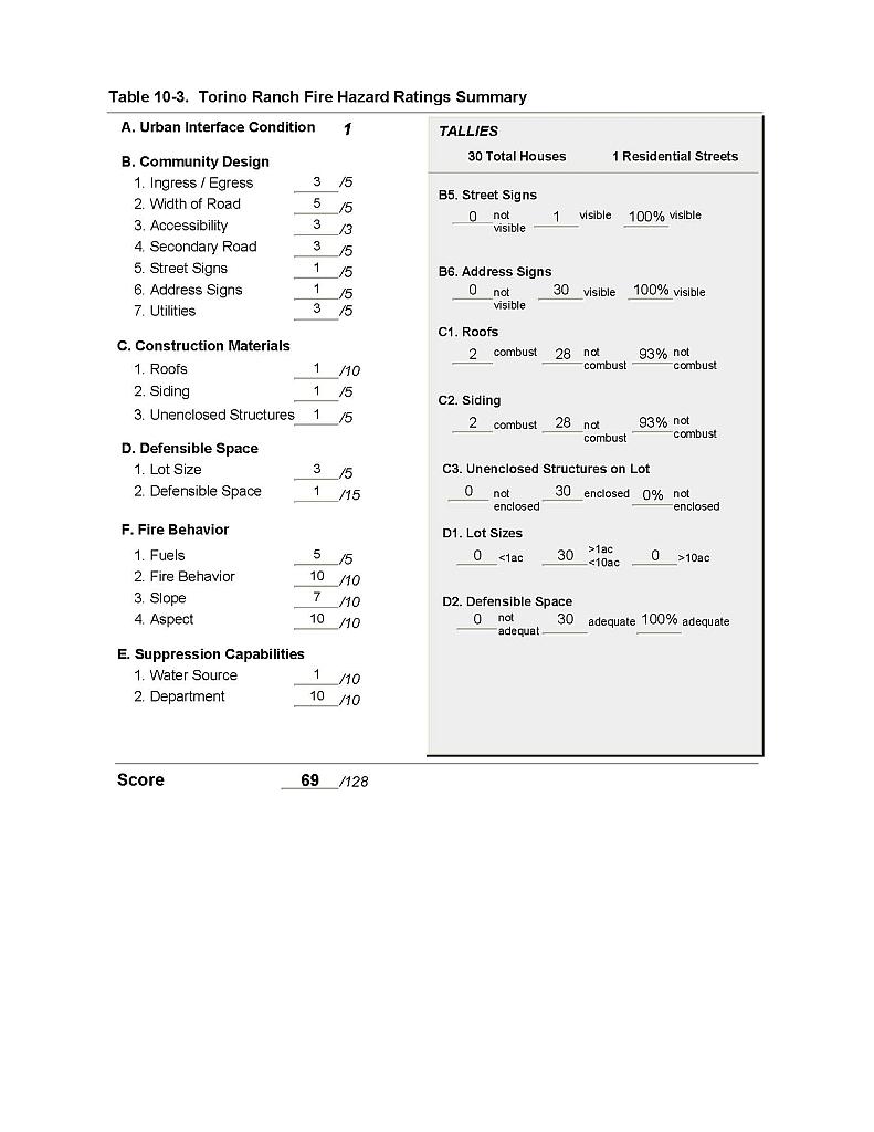 |
Figure 10-1 Torino Ranch Fire History and Proposed Mitigation Projects |
 |
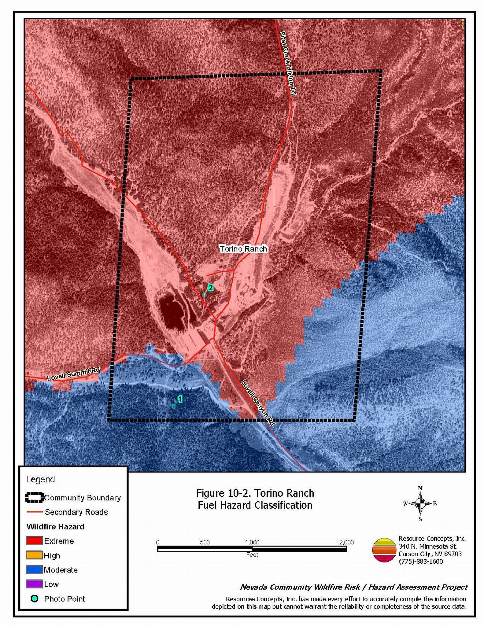
Figure 10-2 Torino Ranch Fuel Hazard Classification |
 |
Figure 10-3 Torino Ranch Fuel Hazard Photo Points
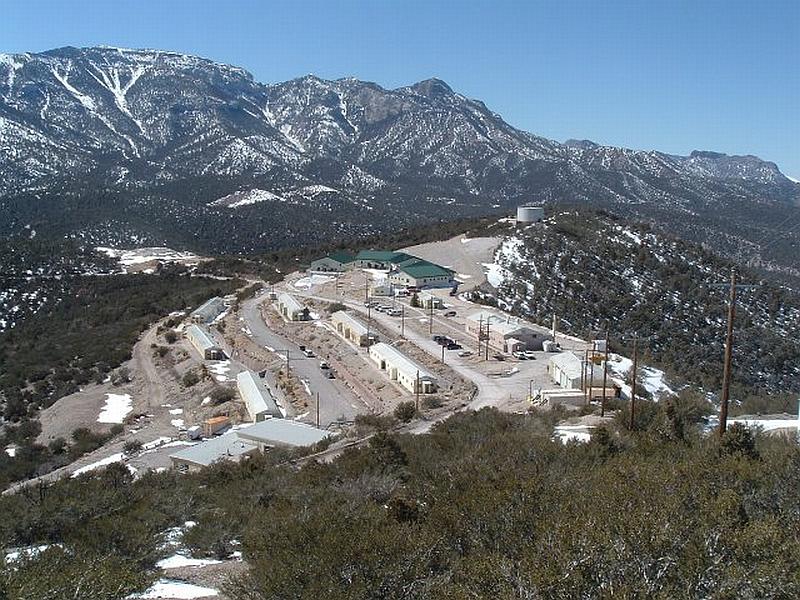
Photo Point 1. 4003285 N. 0627737 E. Direction 020°NNE. Fuel types surrounding the Torino Ranch community include the 2001 Lost Cabin Fire (upper right) and unburned woodlands including pinyon and juniper with a shrub layer of rabbitbrush, sagebrush, manzanita, and ephedra. Fuel loading was estimated at ten tons per acre in the unburned areas. Fuel reduction treatments are recommended for the perimeter of the meadow and ranch building areas.
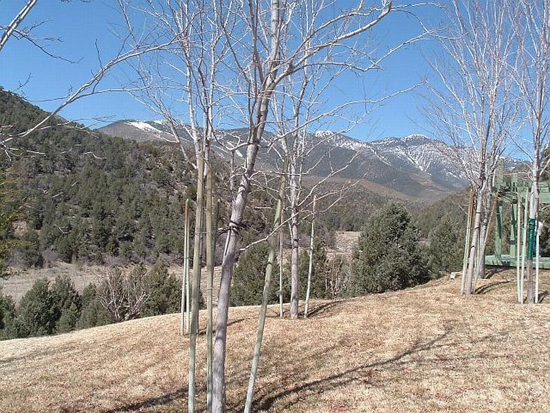
Photo Point 2. 4003643 N. 0627835 E. Pinyon and juniper fuels, fifteen to twenty feet in height on steep slopes present an extreme fuel hazard. A shrub layer of rabbit brush, sagebrush, and manzanita is also present. A fuel reduction treatment is recommended for the toe of the slope.