![]()
![]()
11.0 Trout Canyon
11.1 Risk and Hazard Assessment
Trout Canyon is located on the west side of the Spring Mountains at approximately 5,800 feet in elevation and approximately thirteen miles east of Pahrump. A total of 35 homes were observed in the Trout Canyon area during the hazard assessment, which resulted in classifying Trout Canyon in the Extreme Hazard category (95 points). The rating is primarily attributed to limited access, poor signage, poor defensible space, the potential for extreme fire behavior, and the absence of an organized fire department. Table 11-3 at the end of this section presents a summary of the community hazard rating values for Trout Canyon.
11.1.1 Community Design
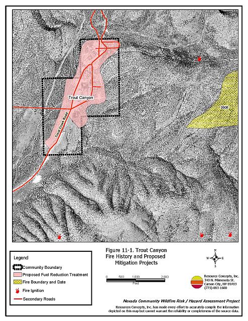
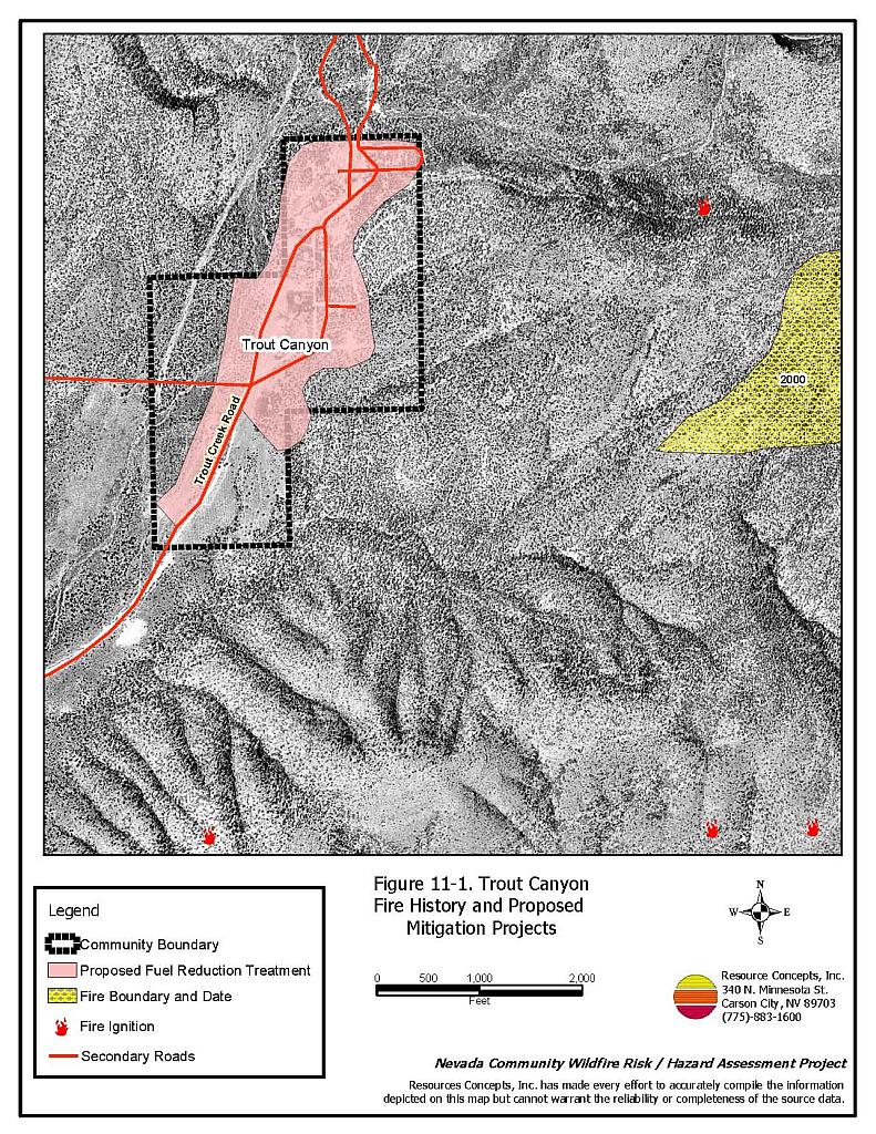
The area surrounding Trout Canyon is defined as an intermix wildland-urban interface condition: structures are scattered throughout the wildland area with no clear line of demarcation between wildland fuels, buildings, and open space. The majority of the lots are between one and ten acres in size. The community boundary is shown in Figure 11-1.
- Access: The primary access into Trout Canyon is via Trout Canyon Road, a dirt two-lane road that is between 20 and 24 feet wide. This is the only primary access road into and out of the community. The road is approximately eleven miles long and intersects with Highway 160 approximately three miles east of Pahrump. The road gradient is steeper than five percent in places. Many of the secondary roads are dead-end streets or do not have adequate turnaround space for fire suppression equipment to maneuver.
- Signage: Street signs are visible on half (two) of the roads in the community. Residential addresses are not visible on any of the homes in the community.
- Utilities: The utilities are both above and below ground and are a moderate to high ignition risk due to areas with heavy vegetation.
11.1.2 Construction Materials
All of the homes in the interface are built with non-combustible roofing materials. Approximately 95 percent of the homes have fire resistant siding materials. Over one-half of the homes in the community (57 percent) have unenclosed balconies, decks, porches, eaves, or attic vents that can create drafty areas where sparks and embers can be trapped, smolder, ignite, and rapidly spread fire to the house.
11.1.3 Defensible Space
Only 25 percent of the homes within the Trout Canyon community meet the minimum requirement for defensible space landscaping in order to minimize damage to the home during a wildfire.
11.1.4 Suppression Capabilities
Wildfire Protection Resources
The nearest formal fire suppression resources are located over twenty miles away. The resources assigned to the Mt. Springs fire station (Clark County Fire Department 79) are listed in Table 11-1. Resources assigned to Pahrump, Mountain Springs, and Blue Diamond represent the next nearest firefighting resources. The figures quoted are based on data available at the time of interviews with local and regional fire authorities and are subject to change.
| Type of Resource | Amount of Equipment | Cooperating Partner (Resource Location) |
|---|---|---|
| (No formal local resources) | Trout Canyon | |
| Type 1 Structure Engine Water Tender Type 6 Quick Attack Engine |
1 1 1 |
Clark County Rural Fire Station 79 (Mountain Springs) |
| Type 3 Brush Engine Type 7 Brush Patrol Engine |
2 1 |
US Forest Service (Station 79, Mountain Springs) |
| Type 3 Brush Engine Type 1 Structure Engine Water Tender |
1 1 1 |
Pahrump Fire Department (Pahrump) |
| Type 4 Brush Engine | 1 | Bureau of Land Management (Pahrump) |
| Type 4 Brush Engine | 1 | US Forest Service (Pahrump) |
| Type 1 Structure Engine Type 3 Brush Engine |
1 1 |
Clark County Rural Fire Station 80 (Blue Diamond) |
| Source: Pers. comm. B. Kourim, March 2004, K. Oliver and C. Gould, October 2004. | ||
It is important to note that fire suppression resources administered by federal agencies such as the US Forest Service or the Bureau of Land Management station across the county line in Pahrump, are considered national resources and are commonly reassigned to areas of higher severity during the fire season. In response to a wildland fire call, interagency dispatch centers locate and dispatch the closest available resource according to incident command and computer-aided dispatch protocols.
Water Sources and Infrastructure
Ponds and reservoirs of various capacities are present on many of the properties in Trout Canyon. These could be utilized as an emergency drafting source in the event of a wildland fire. The next nearest water source is in Mt. Springs 32 miles away.
Work Load
The Clark County Fire Department station in Mt. Springs responded to 98 emergency medical calls and 21 wildland brush fire calls in 2003.
Detection and Communication
There are no fire lookouts in the Trout Canyon area but reconnaissance flights are conducted for the Spring Mountains area. No community sirens are installed.
Community Preparedness
Clark County has an active Local Emergency Planning Committee and has adopted an all-risk, multi-agency emergency plan. The plan is reviewed annually and updated as needed.
11.1.5 Factors Affecting Fire Behavior
The vegetative fuel density in the Trout Canyon area is generally heavy throughout the community. Ground fuels consist of annual grasses. The shrub layer is dominated by big sagebrush (four feet tall), cliffrose (five feet tall), greasewood (five feet tall), ephedra (three feet tall) and manzanita (four feet tall). The tree layer is dominated by pinyon and juniper (twenty feet tall). There have been several fires in the area, most recently the Lost Cabin Fire, which occurred southeast of the community. Vegetative and topographic factors give the Trout Canyon area an extreme fuel hazard rating.
The community is situated in a distinct east-west drainage on the west side of the Spring Mountains. The area acts as a chimney within a narrow canyon resulting in strong erratic winds. These topographic conditions can serve to worsen fire behavior and make control efforts more difficult.
11.1.6 Fire Behavior Worst-Case Scenario
The area has a history of large and moderate fire occurrences. The worst-case scenario for this area would occur on a summer afternoon. A fire resulting from a dry lightning storm with multiple ignitions southwest of the community could block the road and prevent people from evacuating and likewise prevent access by suppression equipment to the area. Under windy conditions a fire could be pushed through the heavy fuels downslope into the community. A wildfire ignition in this area has a high potential to escape initial attack efforts, as those resources must travel thirty to forty minutes to reach the community.
11.1.7 Ignition Risk Assessment
Trout Canyon has a high ignition risk rating. The thick brush and trees create a fuel bed receptive to ignition, and the structures intermixed throughout contribute to the hazard. The potential for an ignition to spread is facilitated by the strong winds that often travel through the canyon.
11.2 Risk and Hazard Reduction Recommendations
The Trout Canyon area is vulnerable to a large fire. Property owners need to take an active role in protecting their property by implementing defensible space treatments, and agencies need to conduct fuels reduction projects.
11.2.1 Defensible Space
Vegetation density, type of fuel, and slope gradient around a home affect the potential fire exposure levels to the home. These conditions define the defensible space area required for individual homes. The goals of defensible space are to reduce the risk of property loss from wildfire by eliminating flammable vegetation near the home. In turn, this lowers the chances of a wildfire spreading onto adjacent properties and it aids firefighters in their efforts to protect property against an approaching wildfire. Guidelines for establishing and improving defensible space around residences and structures in the community are given below and described in greater detail in Appendix E.
Private Property Owners
- Remove, reduce, and replace vegetation around homes. Keep this area:
- Lean: There are only small amounts of flammable vegetation.
- Clean: There is no accumulation of dead vegetation or other flammable debris.
- Green: Existing plants are healthy and green during the fire season.
- Limb deciduous and coniferous tree branches a minimum of four feet from the ground, but remove no more than one-third of the original canopy. Remove all dead and diseased branches, duff, and shrubs from beneath trees to prevent fire from climbing into the tree canopy.
- If residents elect to keep some pinyon or juniper trees close to the home for aesthetic reasons, remove other native trees or ladder fuels (shrubs or debris) from underneath the trees or from within a minimum of thirty feet of the tree crown.
- Enclose wood decks and porches. If this is not possible, keep the area beneath wood decks and porches free of weeds and other flammable debris. Where possible, install screens around unenclosed overhangs.
- Thin fuels for a distance of thirty feet on either side of all driveways. Remove pinyon and juniper trees and thin ground fuels to a spacing of two times their height. Prune tall shrubs to eighteen inches in height.
- Clear vegetation and combustible materials from around propane tanks for a minimum of ten feet.
- Clear pine needles, leaves, and debris from roofs and rain gutters.
- Immediately remove all cleared vegetation to an approved disposal site. This material dries quickly and poses a fire risk if left on site.
- Install screens over attic vents to prevent sparks from entering the attic.
- Ensure that all branches are at least fifteen feet from chimneys and other heat sources. Install spark arrestors or screens on fireplace and wood stove chimneys.
- Maintain defensible space annually.
Clark County Fire Department
- Conduct courtesy inspections of home defensible space measures.
11.2.2 Fuel Reduction Treatments
Recommendations provided below focus on the reduction of fuels along county roadways and the development of fuelbreaks in key locations around the Trout Canyon community. A shaded fuelbreak is a fuels reduction treatment that alters the spacing and arrangement of combustible fuels in areas where the current fuel arrangement could support a catastrophic wildfire. If properly maintained, a shaded fuelbreak can eliminate the continuity of fuels in the tree, shrub, and ground layers. As a result, the heat intensity and rate of spread of an oncoming wildfire can be reduced considerably, offering conditions where a fire can be more safely and effectively managed on the ground.
Shaded Fuelbreak and Fuel Reduction Treatment Guidelines
The following specifications apply to all treatment areas in this chapter.
- Broadcast seed in fuelbreak areas prior to fuel removal to enhance soil stabilization and the establishment of fire-resistant vegetation and to prevent noxious weed invasions. Use a pre-suppression seed mixture appropriate for the local climate and soil conditions, such as the one recommended in Appendix E.
- Thin trees to a spacing equivalent to two times the height of the trees. The Nevada Forest Practice Act restricts the use of heavy equipment on slopes greater than thirty percent. Consult with a forester from the Nevada Division of Forestry for technical guidance about permitting and carrying out thinning operations on steep slopes.
- If a traditional, even-spaced thinning is not desired, it is permissible to thin trees in a cluster-mosaic formation laid out by a forestry professional.
- Limb all branches on pinyon and juniper trees a minimum of four feet from the ground, not to exceed one-third of the total tree height.
- Where trees are removed, cut stumps as close to the ground as possible, leaving no stump higher than four inches.
- Keep the area within ten feet of limbed trees free of smaller trees, shrubs, duff, and other ladder fuels.
- Thin areas of dense brush so that remaining shrubs have a spacing (canopy to canopy) equal to twice their height. Further reduce the fuel volume by reducing shrubs to a height of eighteen inches or less.
- Maintain the shaded fuelbreak, thereby limiting the regrowth of woody species.
Property Owners and US Forest Service
- Establish and maintain a 300 foot shaded fuelbreak around structures within and around the community as shown in Figure 11-1.
- Remove annual grasses, weeds, and shrubs for a distance of thirty feet from each edge of the Trout Creek Road. Thin shrubs to a spacing of two times their height.
Clark County Fire Department
- Establish and promote a program for cleaning weeds and debris from around structures and fences in the community.
- Develop a biomass disposal program to facilitate implementation of defensible space and fuel reduction treatments.
Utility Company
- Maintain utility right-of-ways by removing trees and thinning shrubs from beneath power lines and removing all vegetation within fifteen feet of utility poles.
11.2.3 Community Coordination
Coordination among local, state, and federal fire suppression agencies is important in the day-to-day fire prevention activities and becomes critical in the event of a wildland fire. The goal of community coordination is to make the entire community fire safe.
Private Property Owners
- Ensure residential addresses are visible from the road. Address characters should be at least four inches high and reflective. Improving visibility of addresses will make it easier for those unfamiliar with the area to navigate during a wildland fire.
- Coordinate with the Clark County Fire Department and the Clark County Sheriff’s Department to identify any non-ambulatory persons within the community that will need evacuation assistance in the event of a wildland fire.
- Form a local chapter of the Nevada Fire Safe Council. The Nevada Fire Safe Council facilitates solutions to reduce the loss of lives and property from the threat of wildfire in Nevada’s communities. Through the establishment of a local Chapter, communities will become part of a large network for sharing information and notifications of programs and funding opportunities for fire mitigation projects such as those listed in this report. The Nevada Fire Safe Council will accept and manage grants and contracts on the Chapter’s behalf through its non-profit status. The Nevada Fire Safe Council will provide assistance and support to communities to complete fire safe plans, set priorities, educate and train community members, and promote success stories of its members. To form a local Chapter or for more information contact the:
Nevada Fire Safe Council
1187 Charles Drive
Reno, Nevada 89509
www.nvfsc.org
Clark County
- Ensure cooperation between the Assessor’s office and the Roads Department to ensure that all new development roads are named, mapped, and identified with GPS locations.
- Adopt local ordinances that require all future development in the county to meet the National Fire Codes regarding to road and building construction, water supply, and fire service needs (turnaround space, pull-outs, etc.).
- Adopt local ordinances to require implementation of fuel reduction treatments and defensible space prior to issuing building permits.
Clark County Fire Department
- Develop and enforce brush clearance and biomass disposal programs.
- Install a community siren as a communication tool for evacuation.
11.2.4 Public Education
Public education is critical in communities such as Trout Canyon that have limited fire suppression resources. Informed community members will take the initiative required to lead efforts of a scale sufficient to effectively reduce the threat that wildland fires present to the entire interface community.
Clark County Fire Department
- Distribute copies of the publication “Living with Fire”to all property owners. This publication is free of charge. Copies can be requested from the University of Nevada Cooperative Extension.
- Hold an annual community fire awareness event and distribute public education materials on the dangers of fireworks.
- Contact the University of Nevada Cooperative Extension and the Bureau of Land Management for assistance with public education.
11.2.5 Fire Suppression Resources and Training
Clark County Fire Department
- Comply with National Wildfire Coordinating Group 310-1 standards for wildland fire training and equipment.
Bureau of Land Management and US Forest Service
- Move additional resources into the area on high hazard days if available or ensure volunteer resources are adequate for high hazard days.
Bureau of Land Management and Clark County Fire Department
- Develop a helicopter dip site for use during initial attack such as ponds, tanks, etc. Repair existing pond sites to serve as dip sites for helicopters or drafting sites for engines and tenders.
- Investigate the purchase of fire blocking gels or foams that can be applied to structures and to vegetation in order to create an additional layer of fire protection.
Private Property Owners
- Install 1,000-gallon water storage tanks for use during structure protection efforts, especially during wildland fire events. These tanks should be gravity operated or have pumps equipped with generators in the event that a wildland fire eliminates electrical power to the community.
- Investigate the purchase of a fire blocking gel for buildings. These products come in the form of gels or foams that can be applied to structures and to vegetation in order to create an additional layer of fire protection.
11.3 Summary of Recommendations
| Involved Party | Recommended Treatment | Recommendation Description |
|---|---|---|
| Property Owners | Defensible Space | Remove, reduce and replace vegetation around home according to the defensible space guidelines in Appendix E. |
| Community Coordination | Ensure that address signs are clearly visible from the road. Form a local chapter of the Nevada Fire Safe Council. Identify non-ambulatory residents in the community that may need assistance with evacuation |
|
| Fire Suppression Resources and Training | Install 1,000-gallon water storage tanks for fire suppression. Investigate the purchase and use of fire blocking foams and gels for individual property protection in the wildland-urban interface. |
|
| Property Owners and US Forest Service |
Fuels Reduction | Construct and maintain a shaded fuelbreak 300 feet wide around structures within and surrounding the community. Remove annual grasses and weeds and thin shrubs along Trout Creek Road. |
| US Forest Service and Bureau of Land Management | Fire Suppression Resources and Training | Move additional resources into the area on high fire hazard days. |
| Clark County | Community Coordination | Ensure cooperation between the Assessor’s Office and the Roads Department so that all roads in new developments are named, signed, mapped, and identified with GPS locations. Adopt county ordinances that enforce the implementation and maintenance of defensible space. Require all future development in the County meet the National Fire Codes with regard to community design, building construction and spacing, road construction, water supply, and emergency access. |
| Clark County Fire Department | Defensible Space | Conduct courtesy inspections of defensible space condition and defensible space treatments on private property. |
| Fuels Reduction | Establish and promote a program for cleaning weeds and debris from around structures and fences in the community. Develop a biomass disposal program. |
|
| Fire Suppression Resources and Training | Comply with NWCG 310-1 training and equipment standards. Evaluate the use of fire blocking foams and gels for additional building protection in the wildland-urban interface. |
|
| Public Education | Distribute copies of “Living with Fire” to all property owners living in Trout Canyon. Hold an annual community fire awareness event and distribute educational materials on the wildland fire dangers of fireworks. Contact the Bureau of Land Management and the University of Nevada Cooperative Extension for assistance with public education activities. |
|
| Community Coordination | Install a community siren to advise residents of evacuation orders. Repair existing ponds and develop new sources as dip sites for helicopters and drafting sites for engines and tenders. |
|
| Utility Company | Fuels Reduction | Remove trees within overhead utilities corridors; completely remove all vegetation within fifteen feet of utility poles. |
Table 11-3. Trout Canyon Fire Hazard Ratings Summary |
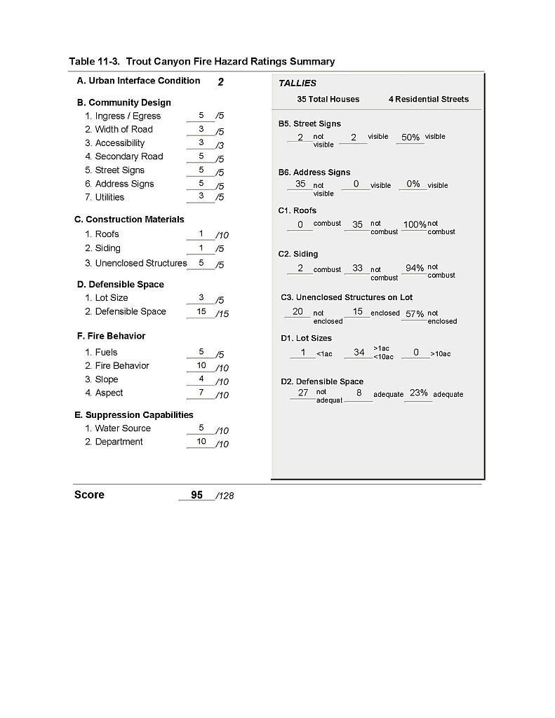 |
Figure 11-1 Trout Canyon Fire History and Proposed Mitigation Projects |
 |
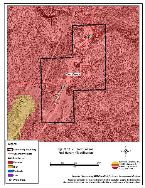
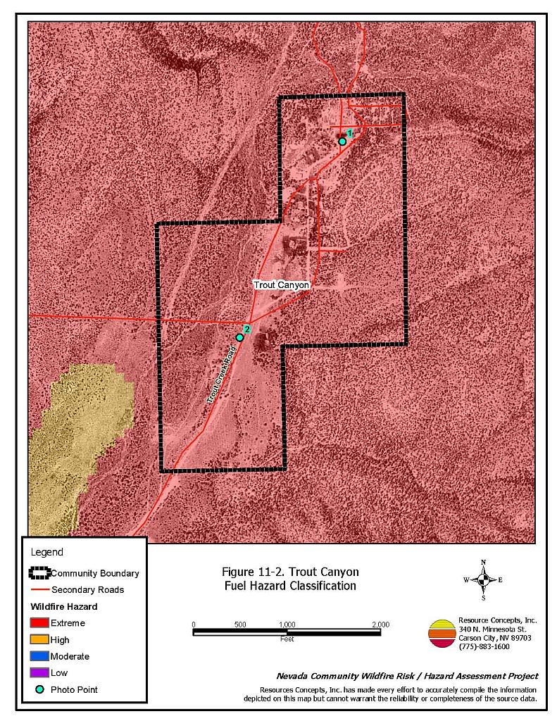
Figure 11-2 Trout Canyon Fuel Hazard Classification |
 |
Figure 11-3 Trout Canyon Fuel Hazard Photo Points
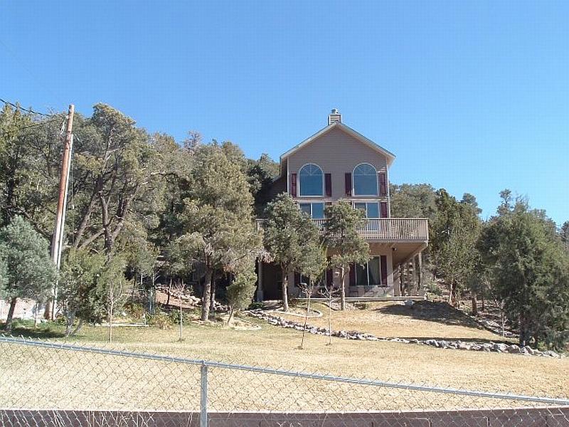
Photo Point 1. 4005164 N. 0618845 E. Direction 148°SSE. Dense pinyon adjacent to structures creates an extreme fire hazard and potential for loss of the home. Creation of adequate defensible space is recommended for property owners in this community.
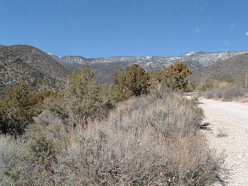
Photo Point 2. 4004528 N. 0618511 E. Direction 010°NNE. Extreme fuel hazard in the interface area around Trout Canyon is created by dense sagebrush, cliffrose, and Utah juniper. Fuel loading was estimated at eight to ten tons per acre. A fuel reduction treatment is recommended for the perimeter of the community.