![]()
![]()
13.0 Goodsprings
13.1 Risk and Hazard Assessment
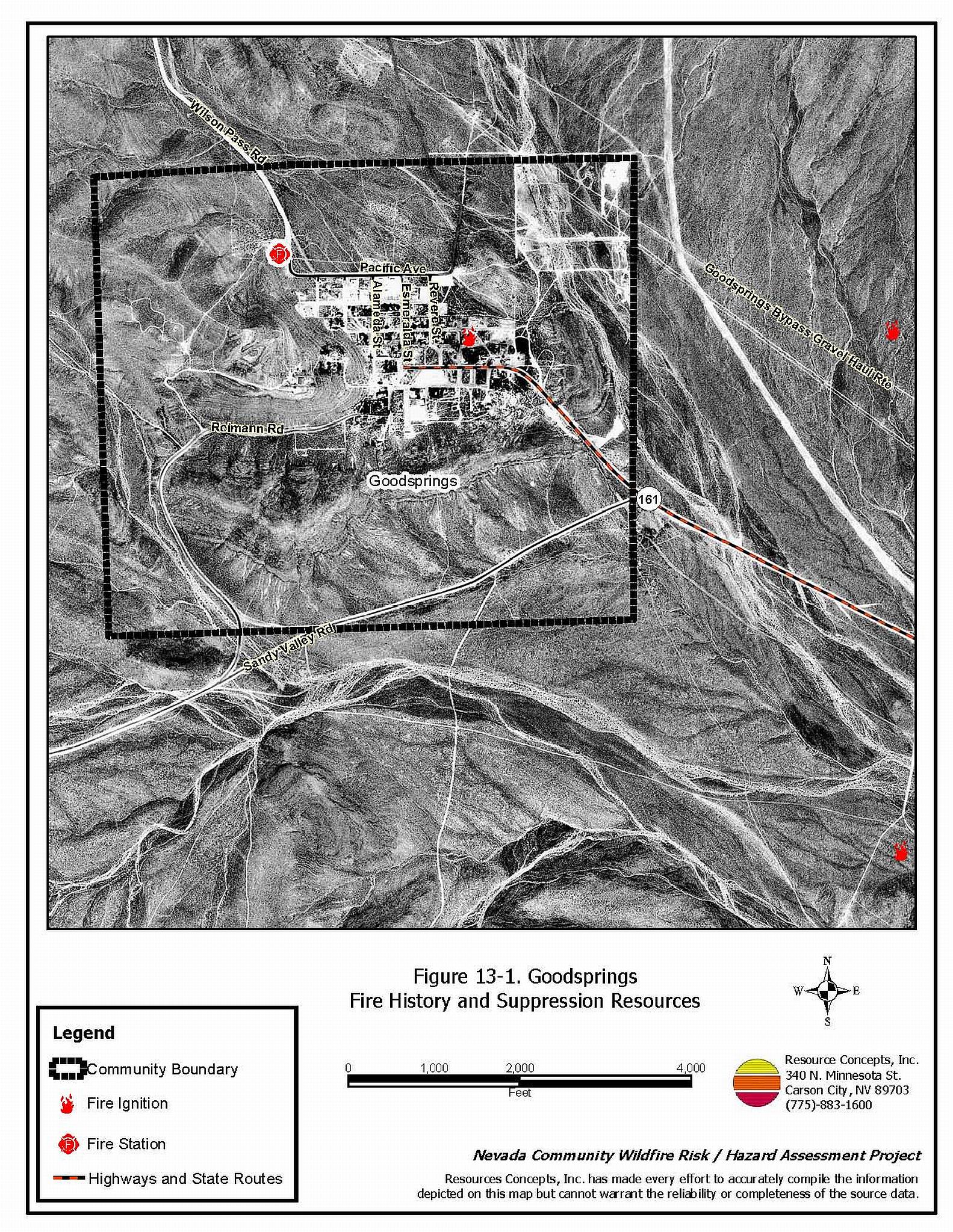
Goodsprings is located along Interstate 15 at the California/Nevada border, forty miles south of Las Vegas. Goodsprings is a small community with approximately 100 structures. The assessment resulted in classifying Goodsprings in the Moderate Hazard category (48 points). The rating is primarily attributed to moderate fuel loading and limited water sources. Table 13-3 at the end of this section presents a summary of the community hazard rating values for Goodsprings.
13.1.1 Community Design
The area surrounding Goodsprings is characteristic of a classic wildland-urban interface condition, with a clear line of demarcation between building structures and wildland fuels. There are areas of moderate brush and debris within the community. Eighty percent of residential lots are less than one acre in size; the other twenty percent are on parcels measuring between one and ten acres. The community boundary is shown in Figure 13-1.
- Access: The primary access to Goodsprings is State Route 161. The road gradient is less than five percent. There is adequate turnaround space for fire suppression equipment to maneuver in the community.
- Signage: Street signs are visible on all of the roads in the community. Addresses are visible on half of the houses. Clear and visible street signs and residential addresses are important to aid firefighters in locating homes during low visibility conditions that occur during a wildland fire.
- Utilities: Power lines and right-of ways in Goodsprings have been maintained and generally pose a low ignition risk.
13.1.2 Construction Materials
All structures in the interface are built with non-combustible roofing materials and 85 percent have fire resistant siding materials. Approximately one-quarter of the structures in the community have unenclosed balconies, decks, porches, eaves, or attic vents that can create drafty areas where sparks and embers can be trapped, smolder, ignite, and rapidly spread fire to the house.
13.1.3 Defensible Space
Approximately seventy percent of the structures within the Goodsprings community meet the minimum requirements for defensible space landscaping to minimize property damage or loss of the home during a wildfire.
13.1.4 Suppression Capabilities
Wildfire Protection Resources
Clark County Fire Department Station 78, located in Goodsprings, is an all volunteer fire department that reported having eight members at the time that interviews were conducted for this report. Table 13-1 lists the fire suppression resources assigned to the volunteer fire department and additional County resources that would be dispatched through the Clark County Fire Alarm office to respond to a reported wildland fire.
| Type of Resource | Amount of Equipment | Cooperating Partner (Resource Location) |
|---|---|---|
| Water Tender Type 6 Quick Attack Engine Basic Life Support (BLS) Rescue |
1 1 1 |
Clark County Rural Fire Station 78 (Goodsprings) |
| Type 3 Brush Engine Type 7 Brush Patrol Engine |
1 1 |
US Forest Service (Station 79, Mountain Springs) |
| Source: Steve McClintock, pers. comm., April and October 2004. | ||
The US Forest Service, the Bureau of Land Management, and the Nevada Division of Forestry provide mutual aid - the federal agencies through the Las Vegas Interagency Communications Center and the Nevada Division of Forestry through the Sierra Front Interagency Dispatch in Minden, Nevada. These systems locate the nearest available fire suppression resource according to computer aided dispatch protocols. It is important to note that these resources are commonly reassigned to areas of higher severity during the fire season.
Water Sources and Infrastructure
Water availability for fire suppression in Goodsprings is limited but additional water is available within a twenty minute round trip. Water supply is from wells and one 10,000-gallon storage tank. The water system operates on gravity.
Fire Protection Personnel Qualifications
Volunteer and career firefighters who would respond to a wildfire near Goodsprings have a minimum of NFPA firefighter I and II training and a limited number have had some wildland firefighting training (National Wildfire Coordinating Group 310-1). The Nevada Division of Forestry and US Forest Service personnel met minimum requirements per National Wildfire Coordinating Group 310-1.
Work Load
The Clark County Fire Department station responded to fifteen emergency medical calls and nine wildland brush fire calls in 2003.
Detection and Communication
Wildland fires are reported by calls to 911. The Las Vegas Fire Alarm Office, and local dispatch relay fires to local fire departments.
Financial Support
Funding for Clark County Fire Department annual operating expenses comes from the County General Fund, which is generated primarily through property taxes.
Community Preparedness
Clark County has an active Local Emergency Planning committee and has adopted an all-risk multi-agency emergency plan. The plan is reviewed annually and updated as needed. The Clark County Fire Department reviews proposed development plans for compliance with fire safe codes and ordinances.
13.1.5 Factors Affecting Fire Behavior
The vegetative fuel density in the Goodsprings area is generally moderate throughout the interface area and the fuel hazard was considered moderate. Ground fuels consist of annual grasses. The shrub layer is dominated by bursage (two to four feet tall), and creosote bush (two to eight feet tall). The community is situated in a flat area with a saddle on the south side of town. Surrounding slopes are moderate with a topographic saddle in the hills to the south which may intensify fire behavior.
13.1.6 Fire Behavior Worst-Case Scenario
The worst-case scenario would be a fire starting south of the saddle on the south side of town with strong wind conditions. A wind driven fire would be rapidly funneled through the saddle and pushed towards structures. Firebrands could ignite areas of heavy vegetation or areas needing defensible space or general cleanup and quickly spreading to nearby structures.
13.1.7 Ignition Risk Assessment
Goodsprings has a moderate ignition risk based on the ignition history at the interface.
13.2 Risk and Hazard Reduction Recommendations
Primary recommendations for Goodsprings include the maintenance of defensible space and ongoing community cleanup activities.
13.2.1 Defensible Space
Vegetation density, type of fuel, and slope gradient around a home affect the potential fire exposure levels to the home. These conditions define the defensible space area required for individual homes. The goals of defensible space are to reduce the risk of property loss from wildfire by eliminating flammable vegetation near the home. In turn, this lowers the chances of a wildfire spreading onto adjacent properties and it aids firefighters in their efforts to protect property against an approaching wildfire. Guidelines for establishing and improving defensible space around residences and structures in the community are given below and described in greater detail in Appendix E.
Property Owners
Density and type of fuel around a home determines the potential fire exposure levels to the home. The goal of defensible space is to reduce the chances of a wildfire spreading onto property and burning through to the home; properly maintained defensible space also gives firefighting personnel enhanced conditions to protect property. General guidelines for improving defensible space around residences and structures in the community are provided below.
- Remove, reduce, and replace vegetation around homes. Keep this area:
- Lean: There are only small amounts of flammable vegetation.
- Clean: There is no accumulation of dead vegetation or other flammable debris.
- Green: Existing plants are healthy and green during the fire season.
- Remove dead and diseased tree branches. For deciduous and coniferous trees, limb branches a minimum of four feet from the ground, but not more than one-third of the tree crown, to reduce ladder fuels. Remove all dead and diseased branches and duff from beneath remaining trees.
- Thin shrubs and other brush to a distance equal to twice their height (crown to crown).
- Enclose wood decks and porches. If this is not possible, keep the area beneath wood decks and porches free of weeds and other flammable debris. Where possible, install screens around unenclosed overhangs.
- Clear vegetation and combustible materials from around propane tanks for a minimum of ten feet.
- Clear leaves and debris from roofs and rain gutters.
- Mow grass to a height of no more than three inches.
- Coordinate a general community cleanup effort.
- Immediately remove all cleared vegetation to an approved disposal site. This material dries quickly and poses a fire risk if left on site.
- Remove all abandoned wood structures in order to reduce the fuel hazard that these buildings present.
- Install screens over attic vents to prevent sparks from entering the attic.
- Ensure that all branches are at least fifteen feet from chimneys and other heat sources. Install spark arrestors or screens on fireplace and wood stove chimneys.
- Maintain defensible space annually.
Clark County Fire Department
- Conduct courtesy inspections of home defensible space measures.
13.2.2 Fuel Reduction Treatments
As noted above, primary recommendations for Goodsprings includes the maintenance of defensible space and ongoing community cleanup activities. Larger-scale fuels reduction projects are not proposed. Fuels reduction activities are proposed along utility lines.
Utility Company
- Remove vegetation for a distance of thirty feet around power poles with transformers. It is important to keep power line corridors clear of flammable vegetation, especially around power poles and beneath transformers, as fires have been known to start from arcing power lines during windy conditions. Keeping flammable vegetation cleared from beneath power lines and around power poles reduces additional threats that wildfires present to electric utility infrastructure.
13.2.3 Community Coordination
Coordination among local, state and federal fire suppression agencies is important in the day-to-day fire prevention activities and becomes critical in the event of a wildland fire. The goal of community coordination is to make the entire community fire safe.
Private Property Owners
- Make sure residential addresses are visible from the road. Address characters should be at least four inches in height and reflective. Improving visibility of addresses will make it easier for those unfamiliar with the area to navigate an area during a wildland fire.
- Form a local chapter of the Nevada Fire Safe Council. The Nevada Fire Safe Council facilitates solutions to reduce the loss of lives and property from the threat of wildfire in Nevada’s communities. Through the establishment of a local Chapter, local communities will become part of a large network for sharing information and receive notifications of programs and funding opportunities for fire mitigation projects such as those listed in this report. The Nevada Fire Safe Council will accept and manage grants and contracts on the Chapter’s behalf through its non-profit status. The Nevada Fire Safe Council will provide assistance and support to communities to complete fire safe plans, set priorities, educate and train community members and promote success stories of its members. To form a local Chapter or for more information contact the:
Nevada Fire Safe Council
1187 Charles Drive
Reno, Nevada 89509
www.nvfsc.org
Clark County
- Allow burning only under a permit process or establish designated community burning days.
13.2.4 Public Education
Public education is an important tool to engage public participation in making a community fire safe. Informed community members will take the initiative required to lead efforts of a scale that can effectively reduce the threat that wildland fires present to the entire interface community.
Clark County Fire Department
- Distribute copies of the publication “Living with Fire” to all property owners. This publication is free of charge. Copies can be requested from the University of Nevada Cooperative Extension.
13.2.5 Fire Suppression Resources and Training
Clark County Fire Department
- Install a 50,000-gallon water tank for firefighting resources.
- Comply with minimum standards regarding training and personal protective equipment for all firefighters in accordance with the Wildland and Prescribed Fire Qualification System Guide PMS 310-1. (See Section 4.2 of this report for a description of these standards).
13.3 Summary of Recommendations
| Involved Party | Recommended Treatment | Recommendation Description |
|---|---|---|
| Property Owners | Defensible Space | Remove, reduce, and replace vegetation around homes according to the guidelines in Appendix E. Maintain defensible space as needed to keep the space lean, clean, and green. |
| Community Coordination | Make sure that residential addresses are clearly visible from the road Form a local chapter of the Nevada Fire Safe Council. |
|
| Clark County Fire Department | Public Education | Distribute copies of “Living with Fire” to all property owners living in Lee Canyon. |
| Fire Suppression Resources and Training | Install a 50,000 gallon water tank. Comply with NWCG 310-1 training and equipment standards. |
|
| Clark County | Community Coordination | Allow burning only under a permit process or on designated community burn days. |
| Utility Company | Fuels Reduction | Clear all vegetation surrounding the electrical transfer station. Remove trees and trim shrubs within overhead utilities corridors; completely remove all vegetation within fifteen feet of utility poles. |
Table 13-3. Goodsprings Fire Hazard Ratings Summary |
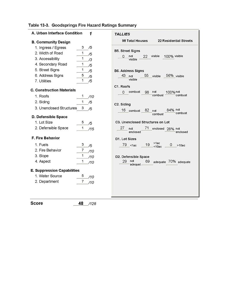 |
Figure 13-1 Goodsprings Fire History and Suppression Resources |
 |