![]()
![]()
14.0 Moapa
14.1 Risk and Hazard Assessment
Moapa is located along the Muddy River in northeast Clark County, three miles north of Interstate 15 and 48 miles east of Las Vegas. A total of seventy homes in the Moapa area were observed during the community assessment, which resulted in classifying Moapa in the Moderate Hazard category (49 points). The moderate rating is primarily attributed to a potential for strong fire behavior, limited water, and limited fire suppression resources. These adverse conditions are somewhat mitigated by good access, adequate defensible space, and fire resistant building materials. Table 14-3 at the end of this section presents a summary of the community hazard rating values for Moapa.
14.1.1 Community Design
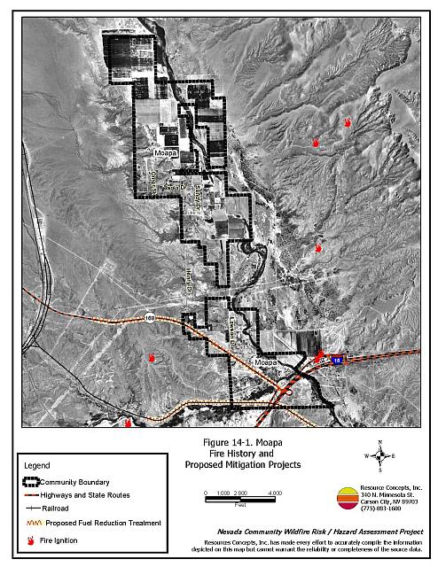
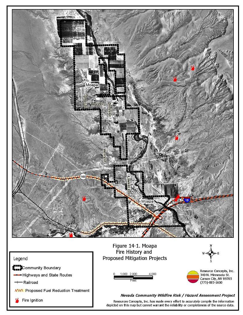
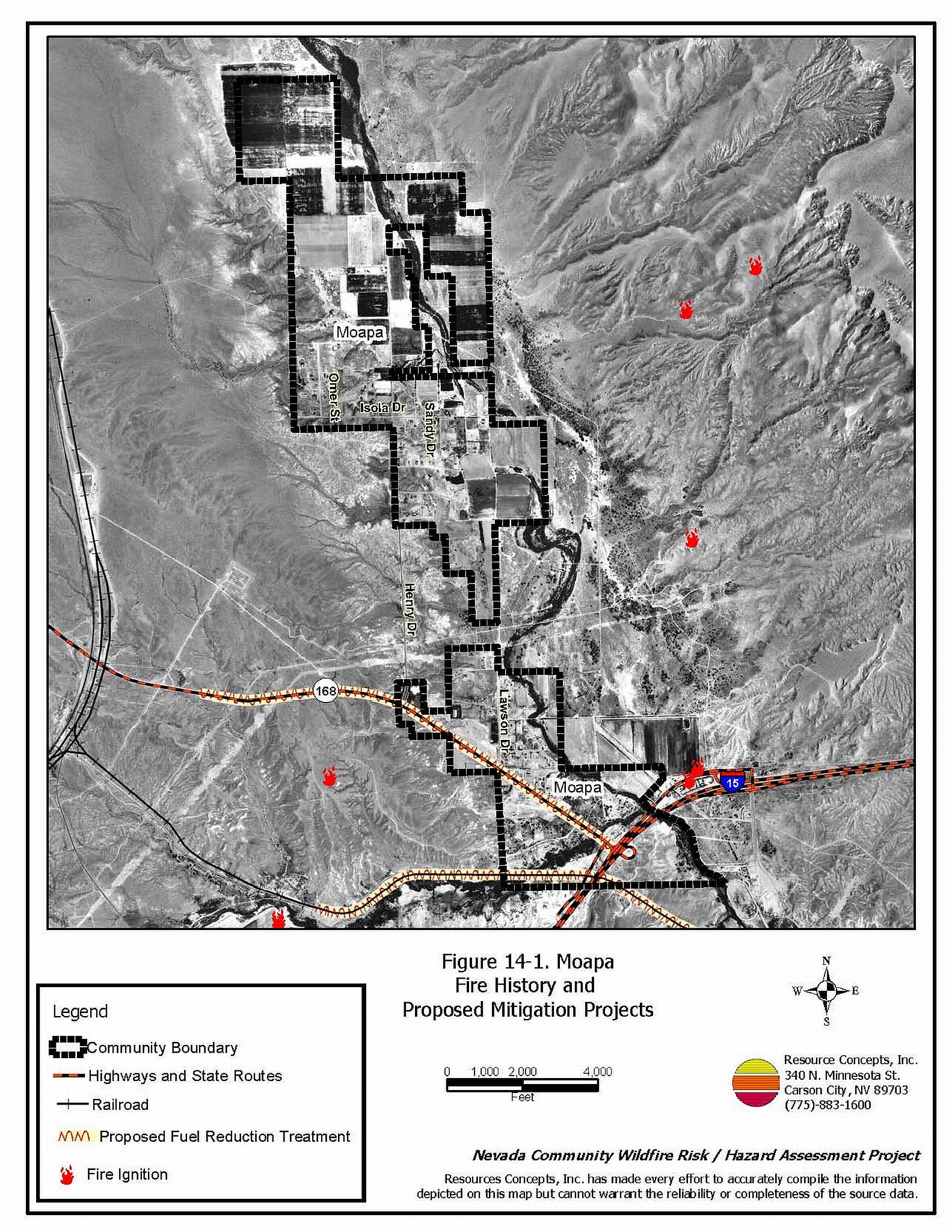
The area surrounding Moapa is a classic wildland-urban interface condition, with a clear line of demarcation between building structures and wildland fuels. Wildland vegetation typically does not continue into the developed areas. Most lots are on parcels of less than one acre in size. The community boundary is shown in Figure 14-1.
- Access: Moapa is accessed via State Route 168 that intersects with Interstate 15 approximately three miles south of the community. State Road 168 is a paved two-lane road greater than 24 feet in width. Secondary roads provide adequate room for fire suppression equipment to maneuver.
- Signage: Street signs are visible on all of the roads in the community. Residential addresses are visible on a little more than half of all the homes in the community. Clear and visible residential addresses are important to aid firefighters in locating homes during low visibility conditions that occur during a wildland fire.
- Utilities: New development areas have underground utilities. Older neighborhoods have above ground utilities. The utilities appear to be a low ignition risk.
14.1.2 Construction Materials
All of the homes in the interface are built with non-combustible roofing materials and 94 percent of the homes have fire resistant siding materials. Approximately one-third of the homes in the community have unenclosed balconies, decks, porches, eaves, or attic vents that can create drafty areas where sparks and embers can be trapped, smolder, ignite, and rapidly spread fire to the house.
14.1.3 Defensible Space
Approximately ninety percent of the homes have landscaping that meets the defensible space requirement to minimize the potential for property damage or loss of the home during a wildfire. There are some exceptions where residences have excess vegetation, stacked wood, or debris in close proximity to the structure.
14.1.4 Suppression Capabilities
Wildfire Protection Resources
The Clark County Fire Department Station 72 in Moapa is an all-volunteer fire department that reported having seven members at the time interviews were conducted for this project. Table 14-1 lists the resources most likely to first respond to a reported wildland fire. Additional County resources are stationed in Logandale and Overton. The Clark County Fire Alarm Office would dispatch neighboring resources as needed.
| Type of Resource | Amount of Equipment | Cooperating Partner (Resource Location) |
|---|---|---|
| Water Tender Type 1 Structure Engine Type 6 Quick Attack Engine Basic Life Support (BLS) Rescue |
1 1 1 1 |
Clark County Rural Fire Station 72 (Moapa) |
| Water Tender Type 1 Structure Engine Type 6 Quick Attack Engine Advanced Life Support (ALS) Rescue |
1 1 1 1 |
Clark County Rural Fire Station 73 (Logandale) |
| Water Tender Type 1 Structure Engine Type 6 Quick Attack Engine Advanced Life Support (ALS) Rescue |
1 1 1 1 |
Clark County Rural Fire Station 74 (Overton) |
| Type 3 Brush Engine | 1 | Bureau of Land Management (Logandale Station) |
| Source: Steve McClintock, Kurt Leavitt pers. comm., 30 March 2004. | ||
The Mesquite Fire department provides mutual aid through the Las Vegas Fire Alarm Office and federal mutual aid is provided by the US Forest Service and the Bureau of Land Management through the Las Vegas Interagency Communications Center. The Nevada Division of Forestry provides mutual aid as coordinated through the Sierra Front Interagency Dispatch in Minden, Nevada. These systems locate the nearest available fire suppression resource according to incident command and computer aided dispatch protocols; it is important to note that Federal resources are commonly reassigned to areas of higher severity during the fire season.
Water Sources and Infrastructure
Water availability for fire suppression in Moapa includes community wells and two tanks with a combined capacity of four million gallons. The water system operates on gravity. Moapa also has access to the Muddy River and several ponds for drafting and helicopter dip sites.
Fire Protection Personnel Qualifications
Volunteer and career firefighters who would respond to a wildfire near Moapa have a minimum of NFPA firefighter I and II training and a limited number have had some wildland firefighting training (National Wildfire Coordinating Group 310-1). The Nevada Division of Forestry and US Forest Service personnel meet minimum requirements per National Wildfire Coordinating Group 310-1.
Work Load
The Moapa Fire Department responded to 136 emergency medical calls and seven wildland brush fire calls in 2003.
Financial Support
The Clark County Fire Department station in Moapa is a tax based fire district. Funding for Clark County Fire Department annual operating expenses comes from the County General Fund, which is generated primarily through property taxes.
Detection and Communication
Fire detection and communication is facilitated by the consolidated Fire Alarm Office in Las Vegas. There is no community siren.
Community Preparedness
Clark County has an active Local Emergency Planning Committee and has adopted an all-risk, multi-agency emergency plan. The plan is reviewed annually and updated as needed.
14.1.5 Factors Affecting Fire Behavior
There are two distinct vegetative fuel types in the Moapa interface area: the Muddy River riparian zone and upland Mojave Desert. Vegetative fuel density along the Muddy River corridor in the Moapa interface area is high and was considered a high fuel hazard. The primary ground fuel is saltgrass. The shrub layer consists of fourwing saltbush, approximately two to four feet in height and creosote bush. Trees ranging from ten to forty feet tall include tamarisk, mesquite, willow, poplar, and palm and are the major components of the fuel load. The fuel load was estimated at four tons per acre and ranged as high as eight tons per acre in the areas with palm trees.
The vegetative fuel density in the uplands is light and consists of creosote bush, fourwing saltbush, and bursage. There is no tree layer. The fuel hazard in the upland areas was considered low.
14.1.6 Fire Behavior Worst-Case Scenario
The worst-case scenario would begin with a fire started in the Muddy River bottom in the late afternoon in the summer. A wind driven fire would put structures along the riparian corridor at risk and threaten structures that lack adequate defensible space.
14.1.7 Ignition Risk Assessment
Moapa has a low ignition risk rating. There is neither significant wildfire history nor recorded historical ignitions in the area surrounding the community. The low, sparse brush in and around the community facilitates these low ignition rates.
14.2 Risk and Hazard Reduction Recommendations
The Moapa Risk Reduction Recommendations focus on tamarisk reduction along the river bottom and wildland training for all firefighters in the Clark County Fire Department. The recommendations are detailed below.
14.2.1 Defensible Space
Vegetation density, type of fuel, and slope gradient around a home affect the potential fire exposure levels to the home. These conditions define the defensible space area required for individual homes. The goals of defensible space are to reduce the risk of property loss from wildfire by eliminating flammable vegetation near the home. In turn, this lowers the chances of a wildfire spreading onto adjacent properties and it aids firefighters in their efforts to protect property against an approaching wildfire. Guidelines for establishing and improving defensible space around residences and structures in the community are given below and described in greater detail in Appendix E.
Property Owner Recommendations
- Remove, reduce, and replace vegetation around homes. Keep this area:
- Lean: There are only small amounts of flammable vegetation.
- Clean: There is no accumulation of dead vegetation or other flammable debris.
- Green: Existing plants are healthy and green during the fire season.
- Enclose wood decks and porches. If this is not possible, maintain the areas to be free of weeds and other flammable debris.
- Make sure residential addresses are visible from the road. Address characters should be at least four inches high and reflective. Improving visibility of addresses will make it easier for those unfamiliar with the area to navigate during a wildland fire.
- Clear vegetation and combustible materials from around propane tanks for a minimum of ten feet.
- Immediately remove all cleared vegetation to an approved disposal site. This material dries quickly and poses a fire risk if left on site.
- Install screens over attic vents to prevent sparks from entering the attic.
- Ensure that all branches are at least fifteen feet from chimneys and other heat sources. Install spark arrestors or screens on fireplace and wood stove chimneys.
- Maintain defensible space annually.
14.2.2 Fuels Reduction
The goal of the fuels reduction treatments is to reduce the fuel hazard due to tamarisk and to allow safe ingress and egress to the community during a wildfire.
Bureau of Land Management
- Continue the tamarisk fuels reduction project in the Muddy River drainage.
Union Pacific Railroad
- Continue to keep the railroad corridor clear of flammable vegetation for a distance of fifteen feet on both sides of the tracks.
Nevada Department of Transportation and Clark County
- Mow roadside vegetation to a maximum height of four inches within thirty feet from the edge of the pavement along both sides of State Route 168 from Interstate 15 through Moapa. Implement similar fuel reduction treatments along the primary roadways in the Moapa community.
14.2.3 Wildland Fire Training and Equipment
Clark County Fire Department Recommendations
- Comply with minimum standards regarding training and personal protective equipment for all firefighters in accordance with the Wildland and Prescribed Fire Qualification System Guide PMS 310-1. (See Section 4.2 of this report for a description of these standards).
14.3 Summary of Recommendations
| Involved Party | Recommended Treatment | Recommendation Description |
|---|---|---|
| Property Owners | Defensible Space | Remove, reduce, and replace vegetation around homes according to the guidelines in Appendix E. Maintain defensible space as needed to keep the space lean, clean, and green. |
| Nevada Department of Transportation and Clark County | Fuels Reduction | Mow vegetation to a maximum height of four inches along both sides of State Route 168 from I-15 north through the community of Moapa. Implement similar roadside treatments along primary roads within the community. |
| Bureau of Land Management | Fuels Reduction | Continue tamarisk abatement projects in the Muddy River drainage. |
| Union Pacific Railroad | Fuels Reduction | Maintain railroad corridor clear of flammable vegetation. |
| Clark County Fire Department | Fire Suppression Equipment and Training | Comply with NWCG 310-1 training and equipment standards. |
Table 14-3. Moapa Fire Hazard Ratings Summary |
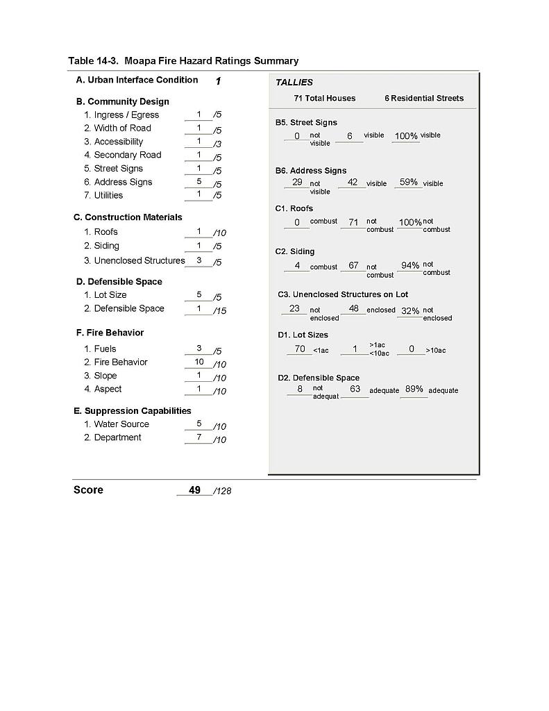 |
Figure 14-1 Moapa Fire History and Proposed Mitigation Projects |
 |