![]()
![]()
22.0 Cottonwood Cove
22.1 Risk and Hazard Assessment
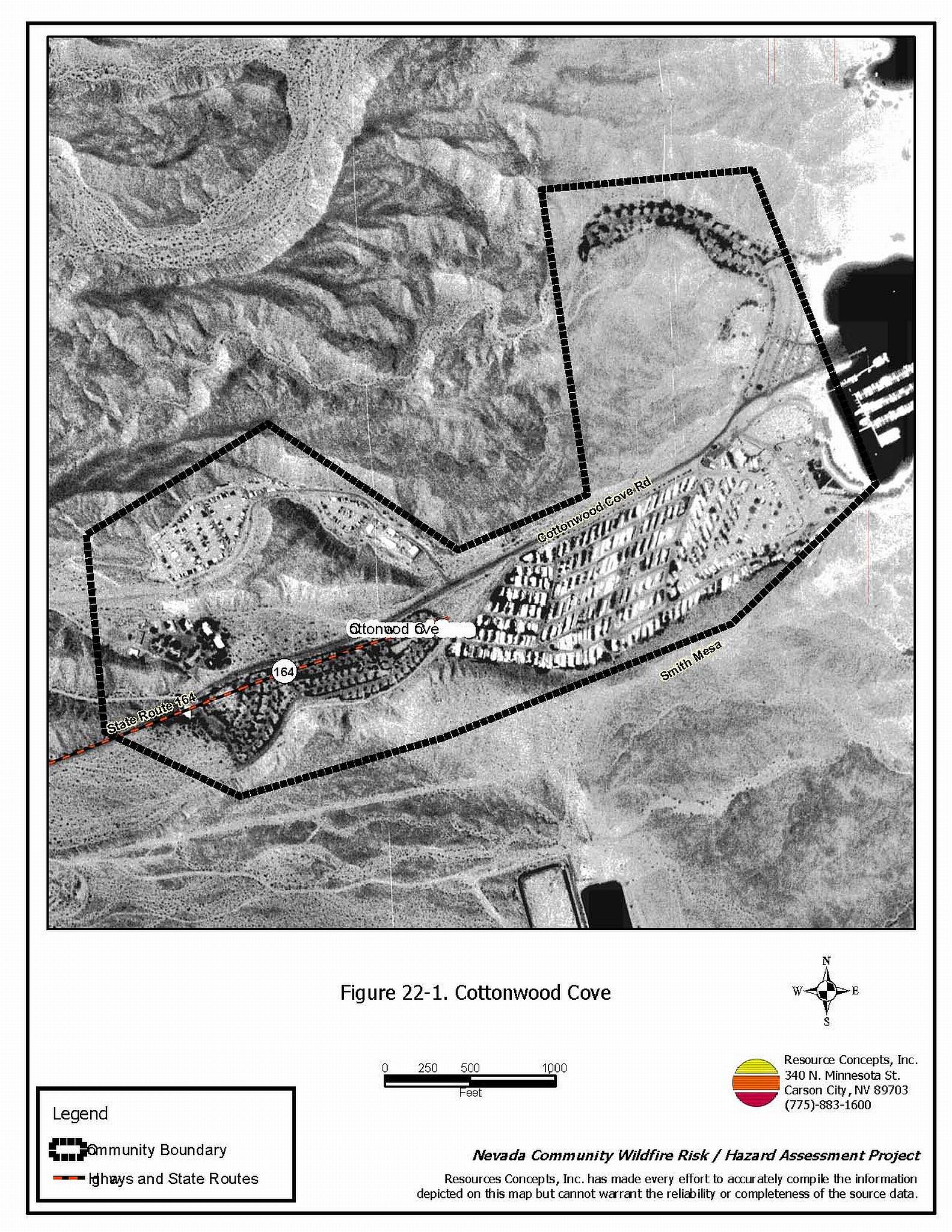
Cottonwood Cove is located in southern Clark County along the Colorado River approximately thirteen miles east of Searchlight. There are approximately 88 homes in the Cottonwood Cove area. The community hazard assessment resulted in classifying Cottonwood Cove in the Low Hazard category (38 points). The rating is primarily attributed to high-density housing, steep slopes, and limited fire protection resources. A summary of the conditions that contributed to the hazard rating for Cottonwood Cove is included in Table 22-3 at the end of this section. The Cottonwood Cove community boundary is shown in Figure 22-1.
22.1.1 Community Design
Cottonwood Cove is a classic wildland-urban interface condition community. There is a clear line of demarcation between building structures and wildland fuels. Wildland vegetation typically does not continue into the development areas. All lots are less than one acre in size.
- Access: The primary access road into Cottonwood Cove is State Route 164. The road is paved and more than 24 feet wide. It is the only access in or out of the community, other than the river. The road grade is less than five percent. There are four secondary roads and all have adequate turnaround space for fire suppression equipment to maneuver.
- Signage: Street signs were visible on all of the roads in the community.
- Utilities: There are overhead power lines and propane tanks in Cottonwood Cove. These pose a low ignition risk due to the sparse fuels.
22.1.2 Construction Materials
All of the homes in the interface are built with non-combustible roofing materials and fire resistant siding materials.
Only one of the 88 residences assessed in the community has an unenclosed feature such as a porch or a deck that could create drafts and provide areas where sparks and embers could be trapped, smolder, ignite, and rapidly spread fire to the home.
22.1.3 Defensible Space
Almost 90 percent of the residences observed in Cottonwood Cove meet the defensible space landscaping requirement to reduce the risk of property damage or loss of a home during a wildfire.
22.1.4 Suppression Capabilities
Wildfire Protection Resources
Cottonwood Cove does not have a fire department, although the National Park Service does have a Type 1 Structure engine assigned to Cottonwood Cove. The Clark County Rural Fire Stations in Searchlight and CalNevAri are thirteen and 26 miles away, respectively, and would provide initial attack to a reported wildland fire near Cottonwood Cove. Table 22-1 lists the types of wildfire resources, cooperating partners and equipment available to Cottonwood Cove to respond to a reported wildland fire. Response times depend on firefighter availability.
| Type of Resource | Amount of Equipment | Cooperating Partner (Resource Location) |
|---|---|---|
| Type 1 Structure Engine | 1 | National Park Service (Nearest available) |
| Water Tender Type 1 Structure Engine Type 6 Quick Attack Engine ILS Rescue |
2 2 2 2 |
Clark Count Rural Fire Stations 84 and 75 (CalNevAri Station 84) (Searchlight Station 75) |
| Type 3 Engine 4x4 Rescue/Squad |
1 | Boulder City Fire Department |
| Type 3 Brush Engine | 1 | Bureau of Land Management (Nearest available) |
| Source: Steve McClintock, March 2004; and K. Oliver, October 2004, pers. comm. | ||
Mutual aid can be requested from the US Forest Service and the Bureau of Land Management through the Las Vegas Interagency Communications Center. The Nevada Division of Forestry also provides mutual aid dispatched from the Sierra Front Interagency Dispatch Center in Minden, Nevada, which locates the nearest available fire suppression resource according to incident command and computer aided dispatch protocols. It is important to note that these resources can be assigned to other emergency incidents during the fire season.
Water Sources and Infrastructure
Water available for fire suppression in Cottonwood Cove includes two one-million gallon storage tanks located in Searchlight, greater than twenty minutes round trip from the community. Lake Mojave is available for drafting and could be used as a helicopter dip site.
Fire Protection Personnel Qualifications
The firefighters have a minimum of NFPA Firefighter I and II training and a limited number of volunteer firefighters have some have wildland firefighting training (National Wildfire Coordinating Group 310-1).
Work Load
The Searchlight CCFD station responded to 274 emergency medical calls and one wildland brush fire call in 2003.
Detection and Communication
Wildland fires are reported by calls to 911. The Las Vegas Fire Alarm Office and local dispatch relay fires to local fire departments.
Financial Support
Annual operating funds for the Clark County Fire Department comes from the County General Fund, which is generated through the collection of property taxes.
Community Preparedness
Clark County has an active Local Emergency Planning Committee and has adopted an all-risk, multi-agency emergency plan. The plan is reviewed annually and updated as needed.
Clark County Fire Department reviews development plans to ensure compliance with the VFC 1997 fire code.
22.1.5 Factors Affecting Fire Behavior
The vegetative fuel density is light throughout the Cottonwood Cove interface area and was considered a low fuel hazard. White bursage and creosote bush are widely spaced with little or no ground fuels in the interspaces. The community is situated in a large east-west oriented drainage.
22.1.6 Fire Behavior Worst-case Scenario
Due to extremely sparse fuel, wildland fire danger is very low. Structures would not be threatened in the unlikely event of a wildfire.
22.1.7 Ignition Risk Assessment
Cottonwood Cove has a low ignition risk rating. There are no wildfire history or ignition incidents on record in the areas surrounding the community. The low ignition potential is facilitated by the low, sparse brush and rocky hillsides in and around the community.
22.2 Risk and Hazard Reduction Recommendations
The primary recommendation for Cottonwood Cove is to continue to maintain defensible space.
22.2.1 Defensible Space Treatments
Defensible space treatments are an essential first line of defense for residential structures. The goal of the treatments is to significantly reduce or remove flammable vegetation within a prescribed distance from structures. (Refer to Appendix E for the recommended defensible space area). Defensible space reduces the fire intensity and improves firefighter and homeowner chances for successfully defending a structure against oncoming wildfire.
Property Owner Recommendations
- During years of increased precipitation and resultant vegetation growth, landowners should implement defensible space for a minimum of thirty feet around all structures by mowing or otherwise eliminating annual grasses and dried weeds.
22.2.2 Fuel Reduction Treatments
Nevada Department of Transportation and Clark County
- Clear vegetation along State Route 164 for a distance of ten feet on each side of the road within the community.
- Following a year of higher than normal precipitation, control annual grass around campgrounds and roads.
22.3 Summary of Recommendations
| Involved Party | Recommended Treatment | Recommendation Description |
|---|---|---|
| Property Owners |
Defensible Space | During years of increased precipitation and resultant vegetation growth, landowners should implement defensible space for a minimum of thirty feet around all structures by mowing or otherwise eliminating annual grasses. |
| NDOT/Clark County | Fuels Reduction | Clear vegetation along SR 164 for a distance of ten feet on each side of the road within the community. Following a wet winter, control annual grass around campgrounds and roads. |
Table 22-3. Cottonwood Cove Wildfire Hazard Rating Summary |
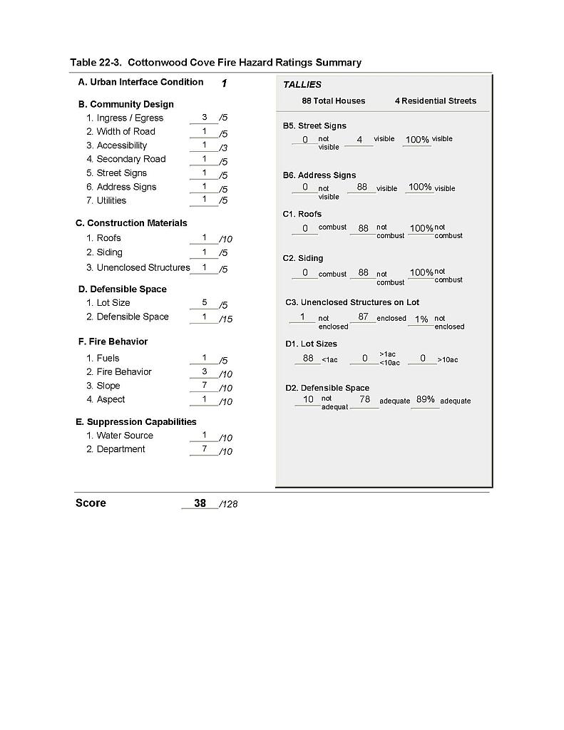 |
Figure 22-1 Cottonwood Cove |
 |