![]()
![]()
23.0 Glendale
23.1 Risk and Hazard Assessment
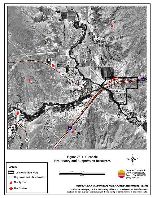
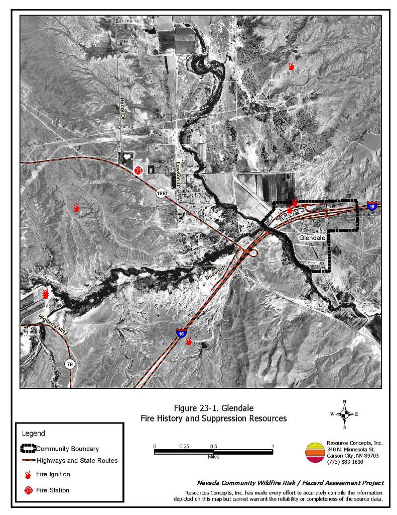
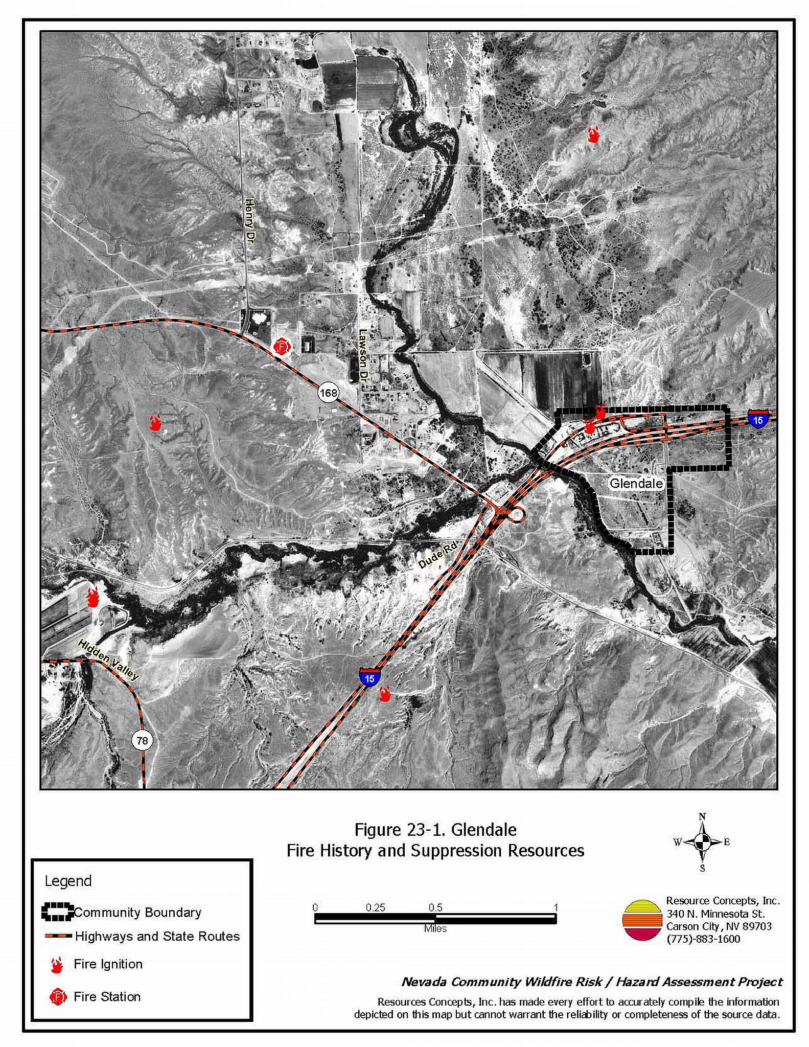
Glendale is a small community located along the Muddy River in northeastern Clark County at the intersection of Interstate 15 and State Route 168 approximately 45 miles east of Las Vegas. The community hazard assessment resulted in classifying Glendale in the Low Hazard category (40 points). The low rating is primarily attributed to sparse fuels, good access, adequate defensible space and fire resistant building materials. A summary of the conditions that contributed to the hazard rating for Glendale is included in Table 23-3 at the end of this section. The Glendale community boundary is shown in Figure 23-1.
23.1.1 Community Design
The area surrounding Glendale is a classic wildland-urban interface condition, with a clear line of demarcation between building structures and wildland fuels. All lots are less than one acre in size.
- Access: Glendale is accessed via State Route 168 which intersects with Interstate 15 approximately just south of the community. State Route 168 is a paved two-lane road greater than 24 feet in width. Secondary roads provide adequate room for fire suppression equipment to maneuver.
- Signage: Street signs were visible on all of the roads in the community. Residential addresses were visible approximately 25 percent of all the homes in the community.
- Utilities: Glendale has above and below ground utilities. The utilities pose a low ignition risk due to well maintained utility corridors and sparse vegetation.
23.1.2 Construction Materials
All of the homes in the interface were built with non-combustible roofing materials and fire resistant siding materials.
Half of the homes in the community had unenclosed balconies, porches, decks or other architectural features that create drafts and provide areas where sparks and embers can be trapped, smolder, ignite, and rapidly spread fire to the home.
23.1.3 Defensible Space
All of the homes had the minimum defensible space required to reduce the risk of property damage or loss of a home during a wildfire.
23.1.4 Suppression Capabilities
Wildfire Protection Resources
The community of Glendale does not have a fire department. Clark County Rural Fire Station 72 in Moapa, an all-volunteer department that reported having seven volunteers at the time that interviews were conducted for this report, provides fire protection for the Glendale community. The volunteer stations in the communities of Logandale and Overton are located to the south, nine and sixteen miles away, respectively. Table 23-1 lists the types of wildfire resources, cooperating partners and equipment available to Glendale to respond to a reported wildland fire. Response times depend on firefighter availability.
| Type of Resource | Amount of Equipment | Cooperating Partner (Resource Location) |
|---|---|---|
| Water Tender Type 1 Structure Engine Type 4 Quick Attack Engine Intermediate Life Support (ILS) Rescue |
1 1 1 1 |
Clark County Rural Fire Station 72 (Moapa) |
| Water Tender Type 1 Structure Engine Type 6 Quick Attack Engine Advance Life Support (ALS) Rescue |
1 1 1 1 |
Clark County Rural Fire Station 73 (Logandale) |
| Water Tender Type 1 Structure Engine Type 6 Quick Attack Engine Advance Life Support (ALS) Rescue |
1 1 1 1 |
Clark County Rural Fire Station 74 (Overton) |
| Type 3 Brush Engine | 1 | Bureau of Land Management (Logandale Station) |
| Source: Steve McClintock, Kurt Leavitt, pers. comm., March 2004. | ||
Mutual aid can be requested from the Mesquite Fire Department, the US Forest Service, and the Bureau of Land Management through the Las Vegas Interagency Communications Center. The Nevada Division of Forestry also provides mutual aid dispatched from the Sierra Front Interagency Dispatch Center in Minden, Nevada, which locates the nearest available fire suppression resource according to incident command and computer aided dispatch protocols. It is important to note that these resources can be assigned to other emergency incidents during the fire season.
Fire Protection Personnel Qualifications
The firefighters have a minimum of NFPA Firefighter I and II training and a limited number of volunteer firefighters have some wildland firefighting training (National Wildfire Coordinating Group 310-1).
Work Load
The Moapa Fire Department responded to 136 emergency medical calls and seven wildland brush fire calls in 2003.
Financial Support
Annual operating funds for the Clark County Fire Department comes from the County General Fund, which is generated through the collection of property taxes.
Detection and Communication
Wildland fires are reported by calls to 911. The Las Vegas Fire Alarm Office and local dispatch relay fires to local fire departments.
Community Preparedness
Clark County has an active Local Emergency Planning Committee and has adopted an all-risk, multi-agency emergency plan. The plan is reviewed annually and updated as needed.
The Clark County Fire Department reviews development plans to ensure compliance with the VFC 1997 fire code.
23.1.5 Factors Affecting Fire Behavior
The interface area around Glendale is flat. There are three vegetative fuel types in the area: the Muddy River riparian corridor, agricultural lands, and the upland Mojave Desert scrub. The vegetative fuels along the Muddy River corridor and along ditches are dense, dominated by tamarisk, mesquite, and willow, ranging from eight to eighteen feet tall. The fuel density was estimated to be six tons per acre and considered a high fuel hazard. Irrigated agricultural lands and upland dominated by sparse creosote bush and white bursage were considered low fuel hazards.
23.1.6 Fire Behavior Worst-case Scenario
The worst-case scenario would begin with a fire in the Muddy River corridor in the late afternoon in the summer, south of the community. There is some potential for fire to spread along the ditch banks and fences due to weed accumulations. The agricultural lands between the river, the community, and the sparse upland vegetation provide a measure of protection from wildfires to the structures in the community.
23.1.7 Ignition Risk Assessment
Glendale has a low wildfire ignition risk potential. There is no significant wildfire history reported for the areas surrounding the community and the ignitions recorded are few.
23.2 Risk and Hazard Reduction Recommendations
The hazard reduction recommendations for Glendale focus on defensible space, tamarisk reduction along the river corridor, and wildland fire training for all firefighters.
23.2.1 Defensible Space Treatments
Defensible space treatments are an essential first line of defense for residential structures. The goal of the treatments is to significantly reduce or remove flammable vegetation within a prescribed distance from structures. (Refer to Appendix E for the recommended defensible space area). Defensible space reduces the fire intensity and improves firefighter and homeowner chances for successfully defending a structure against oncoming wildfire.
Property Owners
- Remove debris and flammable materials from within the defensible space area.
- Immediately dispose of cleared vegetation when implementing defensible space treatments. This material dries quickly and poses a fire risk if left on site.
- Maintain this defensible space as needed to keep the space lean, clean, and green.
- Maintain the areas underneath decks, porches, etc. free of weeds and other flammable debris to prevent sparks lodging, smoldering, and spreading fire to the home.
- Clear vegetation and combustible materials around propane tanks for a minimum of ten feet.
- Assure that residential addresses are visible from the road. Address characters should be at least four inches high, reflective, and posted where the road and driveway meet. Improving visibility of addresses will make it easier for those unfamiliar with the area to navigate during a wildland fire.
23.2.2 Fuel Reduction Treatments
Property Owners/Clark County
- Remove weeds along fences and irrigation ditches.
Bureau of Land Management
- Continue the tamarisk fuel removal and replacement project in the Muddy River watershed.
Union Pacific Railroad
- Maintain railroad right-of-ways free of encroaching vegetation to reduce ignition risks and to function as firebreaks.
23.2.3 Fire Suppression Resources
Clark County Fire Department
- Provide all firefighters with basic wildland fire training and equipment as described in the National Wildfire Coordinating Group (NWCG) Wildland and Prescribed Fire Qualification System Guide PMS 310-1. Provide annual wildland firefighting refresher training and fire shelter training.
23.3 Summary of Recommendations
| Involved Party | Recommended Treatment | Recommendation Description |
|---|---|---|
| Property Owners | Defensible Space | Continue to maintain the defensible space as needed to keep the space lean, clean, and green. Ensure residential addresses are visible from the road. |
| Fuels Reduction | Remove weeds along fences and irrigation ditches. | |
| Bureau of Land Management | Fuels Reduction | Continue to remove and replace tamarisk in the Muddy River riparian area. |
| Union Pacific Railroad | Fuels Reduction | Maintain railroad right-of-ways free of encroaching vegetation to reduce ignition risks and to act as firebreaks. |
| Clark County Fire Department | Fire Suppression Resources and Training | Provide all firefighters with basic wildland fire training and equipment. |
Table 23-3. Glendale Wildfire Hazard Rating Summary |
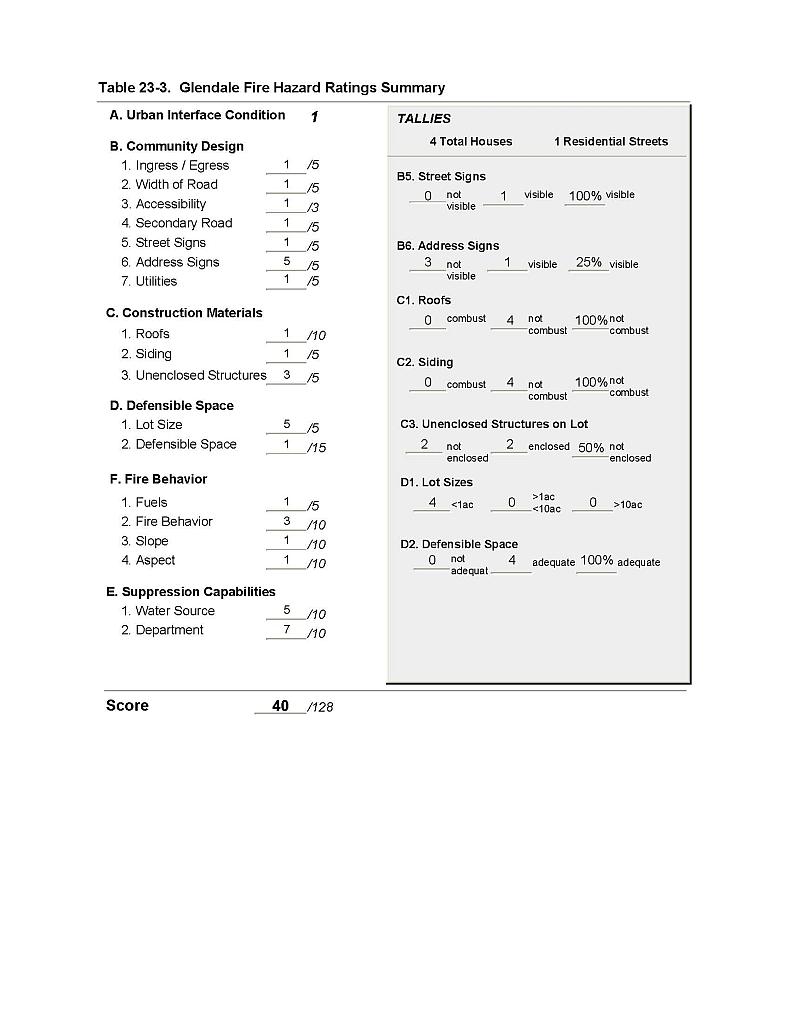 |
Figure 23-1. Glendale Fire History and Suppression Resources |
 |