![]()
![]()
24.0 Henderson
24.1 Risk and Hazard Assessment
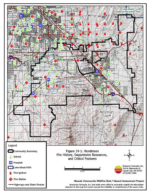
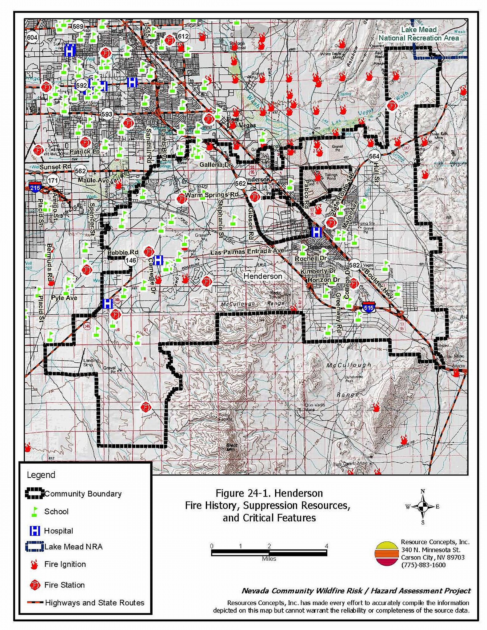
Henderson is south of and adjacent to Las Vegas in southeastern Clark County. The community hazard assessment resulted in classifying Henderson in the Low Hazard category (31 points). The low rating is primarily attributed to good access and signage, adequate defensible space, sparse wildland fuels, fire resistant building materials, and sufficient fire suppression resources. A summary of the conditions that contributed to the hazard rating for Henderson is included in Table 24-3 at the end of this section. The Henderson community boundary is shown in Figure 24-1.
24.1.1 Community Design
The area surrounding Henderson is a classic wildland-urban interface condition, with a clear line of demarcation between building structures and wildland fuels. Wildland vegetation typically does not continue into the development areas. Five percent of the homes were on lots between one and ten acres in size; the rest were on parcels of less than one acre.
- Access: Henderson is accessed via Interstate 95/93 and numerous state routes. Secondary roads are generally wide, paved, two-lane roads and provide adequate room for fire suppression equipment to maneuver.�
- Signage: Street signs are visible on all of the roads in the community. Residential addresses are visible on about 99 percent of the homes in the community.
- Utilities: Utilities are both above and below ground. Utility right-of-ways are well maintained and pose a low ignition risk.
24.1.2 Construction Materials
All of the homes in the interface are built with non-combustible roofing and siding materials.
Approximately seventy percent of the homes observed in the community have unenclosed balconies, porches, decks, or other architectural features that create drafts and provide areas where sparks and embers can be trapped, smolder, ignite, and rapidly spread fire to the home.
24.1.3 Defensible Space
Ninety-eight percent of the homes have landscaping that meets the minimum requirement for defensible space to minimize property damage and the risk of loss to the home during a wildfire.
24.1.4 Suppression Capabilities
Wildfire Protection Resources
The Henderson Fire Department has nine stations throughout the city. There are approximately fifty personnel on duty for each shift providing 24-hour coverage. Each station has Paramedic/Advanced Life Support capability. All nine stations are staffed with a fire engine manned by four personnel, a Captain, an Engineer, a Firefighter, and a Firefighter/Paramedic. Four fire stations are staffed with a paramedic ambulance that provides emergency response and transport to medical facilities within the valley (www.cityofhenderson.com/fire).
| Type of Resource | Amount of Equipment | Resource Location |
|---|---|---|
| Type 1 Structure Engine Ladder Truck Ambulance / Rescue Battalion Chief |
4 1 2 1 |
Henderson Fire Department. |
| Source: Jim Cavalieria, pers. comm., March 2004. | ||
This fire department is primarily equipped and trained to respond to urban incidents and emergencies. Specialized equipment and personnel trained in standard operating guidelines for wildland fire suppression in the interface currently comes from agencies external to the Henderson Fire Department.
Mutual aid can be requested from the US Forest Service, the National Park Service, and the Bureau of Land Management through the Las Vegas Interagency Communications Center. The Nevada Division of Forestry also provides mutual aid dispatched from the Sierra Front Interagency Dispatch Center in Minden, Nevada, which locates the nearest available fire suppression resource according to incident command and computer aided dispatch protocols. It is important to note that these resources can be assigned to other emergency incidents during the fire season.
Water Sources and Infrastructure
Water available for fire suppression in Henderson includes fire hydrants within 500 feet of structures with a minimum capacity of 500 gpm flows. Numerous water storage tanks operate by gravity flow and electric pumps.
Fire Protection Personnel Qualifications
Henderson Fire Department firefighters are trained to the State of Nevada Fire Marshal Firefighter I and II. Some are trained in Hazardous Materials operations and rescue.
Work Load
The Fire Rescue Operations Division responded to 12,198 emergency medical calls, small number of wildland / brush calls, and 6,400 other calls in 2003.
Financial Support
Financial support for the Henderson Fire Department comes from the Henderson General Fund.
Community Preparedness
The City of Henderson has an All Risk Emergency Plan and a Pre-attack Plan. These plans are updated as needed.
The Henderson Fire Department reviews development plans to ensure compliance with the 2000 UBC fire code. The HFD reviews development plans.
24.1.5 Factors that Affect Fire Behavior
The majority of the area around the City of Henderson, with the exception of Las Vegas Wash north of Henderson, is Mojave Desert shrub with short, widely spaced annual grasses, bursage, and creosote bush. Much of the area is rocky. The fuel load was estimated at less than one ton per acre and considered a low fuel hazard. Above normal precipitation could increase fuel loading of the annual grasses. Areas of heavier fuels are mostly associated with topographic depressions.
Along the Las Vegas Wash in the Desert Wetlands Park, fuel loading is dangerously high, estimated at ten to twenty tons per acre. The fuel load consists of tamarisk ten to twenty feet tall, mesquite up to twelve feet tall, and creosote bush and fourwing saltbush up to six feet tall. Urban garbage dumps increase the fuel load in certain areas. There is a history of fire occurrences in the Wash.
24.1.6 Fire Behavior Worst-case Scenario
The worst-case for a wildland fire would occur along the Las Vegas Wash in the Desert Wetlands Park. This area contains the greatest fuel loading in the Las Vegas-Henderson area. A fire in the late afternoon on a summer day would be wind driven, influenced by predominately south-southwest winds or erratic winds from thunder storm activity. This would be a rapidly moving high intensity fire with the potential for hazardous materials releases from garbage dumps. Structures west of the wash would be threatened from a wildfire if erratic winds shifted and came from the east. A fire in the Las Vegas Wash represents one of the highest safety concerns for firefighters in Clark County. Clark County firefighters do not receive regular wildland fire training, they are not issued wildland fire protective equipment or fire shelters, and there are no standard operating guidelines for wildland firefighting.
The worst-case scenario wildland fire outside of the Las Vegas wash would occur during a year with above normal precipitation and high annual grass and forb production. High amounts of dried grasses could be ignited and spread fire through the shrubs under high wind conditions. Existing good defensible space conditions and rapid initial attack should be sufficient to control a fire under these conditions before structures would be threatened.
24.1.7 Ignition Risk Assessment
Henderson has a low ignition risk. There is no significant wildfire or ignition history recorded for the area. The low ignition potential is facilitated by the low, sparse brush in and around the community.
24.2 Risk and Hazard Reduction Recommendations
The hazard reduction recommendations for Henderson focus on the Las Vegas Wash, weed control, and firefighter training.
24.2.1 Defensible Space Treatments
Most of the homes in the interface area are of new construction with good defensible space. Landscaping is done with rock and desert vegetation. Landowners need to keep or prevent annual grass from becoming established in new landscaping.
Property Owners
- Control weeds and annual grass within thirty feet of structures, along driveways, and in disturbed areas by mowing to a height of three inches. This is especially important in years with above normal precipitation.
- Immediately dispose of cleared vegetation when implementing defensible space treatments. This material dries quickly and poses a fire risk if left on site.
- Maintain this defensible space as needed to keep the space lean, clean, and green.
Henderson Fire Department
- Establish and enforce a defensible space program for structures within thick vegetation near the wash.
24.2.2 Fuel Reduction Treatments
City of Henderson
The primary goal for the fuel reduction recommendations is to reduce the fuel hazard from tamarisk trees and other weedy species.
- Work with Clark County and the Nevada Division of Forestry to implement tamarisk reduction projects along the Las Vegas Wash and convert the area back to native vegetation. The Bureau of Land Management has experience implementing this type of program in Clark County.
- Control annual weeds along the edges of roadways and disturbed areas.
24.2.3 Fire Suppression Resources
Henderson Fire Department
- Provide all firefighters with basic wildland fire training and equipment as described in the National Wildfire Coordinating Group (NWCG) Wildland and Prescribed Fire Qualification System Guide 310-1. Provide annual wildland firefighting refresher training and fire shelter training.
24.3 Summary of Recommendations
| Involved Party | Recommended Treatment | Recommendation Description |
|---|---|---|
| Property Owners |
Defensible Space | Control weeds and annual grass within thirty feet of structures, along driveways, and disturbed areas by mowing to a height of three inches. This is especially important after winters with above normal precipitation. Immediately dispose of cleared vegetation when implementing defensible space treatments. This material dries quickly and poses a fire risk if left on site. Maintain this defensible space as needed to keep the space lean, clean, and green. |
| Henderson Fire Department | Fire Suppression Resources | Provide all firefighters with basic wildland fire training and equipment. |
| Defensible Space | Establish and enforce a defensible space program for structures within thick vegetation near the wash. |
Table 24-3. Henderson Wildfire Hazard Rating Summary |
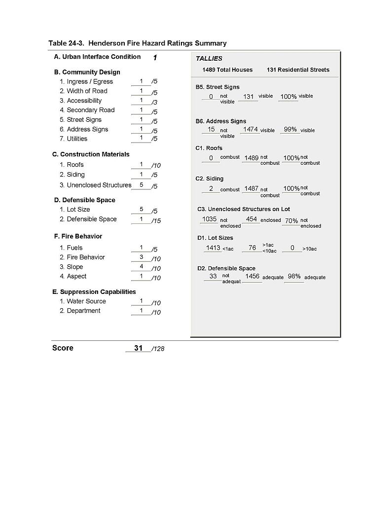 |
Figure 24-1 Henderson Fire History, Suppression Resources, and Critical Features |
 |