![]()
![]()
27.0 Laughlin
27.1 Risk and Hazard Assessment
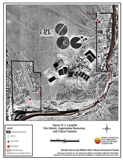
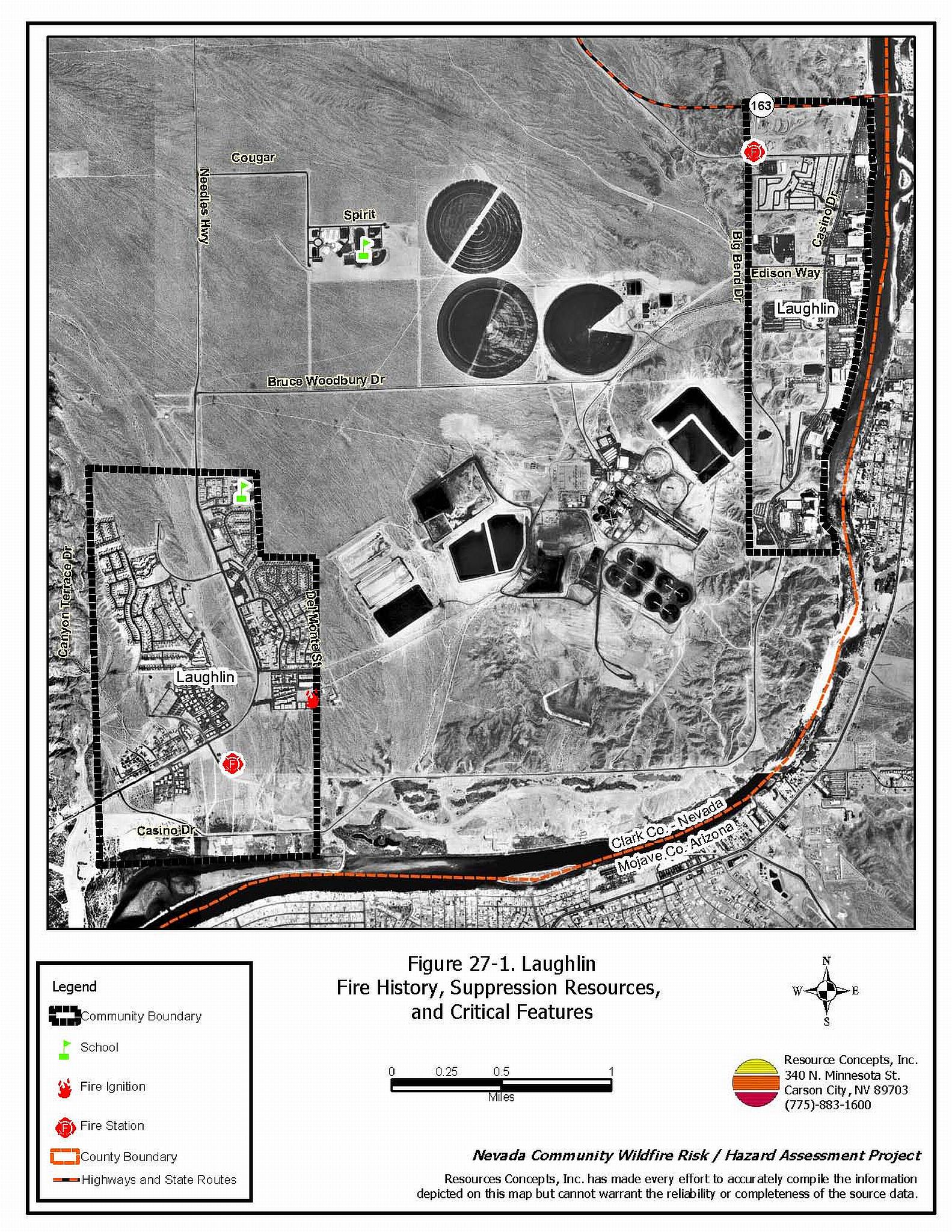
Laughlin is located in southern Clark County along the Arizona/Nevada border on the Colorado River. Laughlin is primarily a tourist destination. The community hazard assessment resulted in classifying Laughlin in the Low Hazard category (26 points). The rating is primarily attributed to good access, good defensible space, non-combustible construction materials, light fuels, and good fire suppression resources. A summary of the conditions that contributed to the hazard rating for Laughlin is included in Table 27-3 at the end of this section. The Laughlin community boundary is shown in Figure 27-1.
27.1.1 Community Design
Laughlin has a classic wildland-urban interface condition, with a clear line of demarcation between building structures and wildland fuels. Wildland vegetation typically does not continue into the developed areas. Most homes are on lots of less than one acre in size.
- Access: The primary road into Laughlin is State Route 163. The primary access road is paved and more than 24 feet wide with a road grade less than five percent. There are several secondary roads and all roads are either loop roads or have adequate turnaround space for fire suppression equipment to maneuver.
- Signage: Street signs are visible on all of the roads in the community. Residential addresses are visible on all of the homes in the community.
- Utilities: Utilities provided to the community are underground and thus do not pose an ignition risk.
27.1.2 Construction Materials
All of the homes in the interface were built with non-combustible roofing materials and fire resistant siding materials.
None of the homes in the community have unenclosed balconies, porches, decks or other architectural features that create drafts and provide areas where sparks and embers can be trapped, smolder, ignite, and rapidly spread fire to the home.
27.1.3 Defensible Space
Ninety-six percent of the homes within the Laughlin community meet the minimum requirements for defensible space landscaping to minimize property damage or the risk of loss to the home during a wildfire.
27.1.4 Suppression Capabilities
Wildfire Protection Resources
Local fire suppression for Laughlin is provided by Clark County Rural Fire Stations 76 in Laughlin and Station 84 in CalNevAri. Laughlin has a career station with fourteen firefighters on duty each day. These stations are primarily equipped to respond to urban fire and emergency situations. Additional county resources are dispatched through the Clark County Fire Alarm Office as needed. The available equipment for initial attack is summarized in Table 27-1.
| Type of Resource | Amount of Equipment | Cooperating Partner (Resource Location) |
|---|---|---|
| Type 1 Structure Engine Ladder Truck Rescue |
2 1 1 |
Clark County Rural Fire Station 76 (Laughlin) |
| Type 1 Engine | 1 | National Park Service (Nearest Available) |
| Type 1 Structure Engine Water Tender Type 6 Quick Attack Engine Intermediate Life Support (ILS) Rescue |
1 1 1 1 |
Clark County Rural Fire Station 84 (CalNevAri) |
| Type 6 Brush Patrol Engine | 1 | Bureau of Land Management (Nearest Available) |
| Source: Steve McClintock, pers. comm., April 2004. | ||
Mutual aid can be requested from the US Forest Service and the Bureau of Land Management through the Las Vegas Interagency Communications Center. The Nevada Division of Forestry also provides mutual aid dispatched from the Sierra Front Interagency Dispatch Center in Minden, Nevada, which locates the nearest available fire suppression resource according to incident command and computer aided dispatch protocols. It is important to note that these resources can be assigned to other emergency incidents during the fire season.
Water Sources and Infrastructure
Water available for fire suppression in Laughlin includes fire hydrants within 500 feet of structures with a minimum flow capacity of 500 gpm, community wells operated by gravity and electric pumps with back-up generators, and water storage facilities with a capacity of over three million gallons. The Colorado River can also be used as a drafting site and helicopter dip spot.
Fire Protection Personnel Qualifications
Firefighters are trained to the State of Nevada entry-level firefighter qualifications (NFPA Firefighter I and II).
Detection and Communication
Wildland fires are reported by calls to 911. The Las Vegas Fire Alarm Office and local dispatch relay fires to local fire departments.
Financial Support
Annual operating funds for the Clark County Fire Department comes from the County General Fund, which is generated through the collection of property taxes.
Community Preparedness
Clark County has an active Local Emergency Planning Committee and has adopted an all-risk, multi-agency emergency plan. The plan is reviewed annually and updated as needed.
27.1.5 Factors Affecting Fire Behavior
The vegetative fuel density in and around Laughlin is generally light. Sparse shrubs include creosote bush and greasewood with occasional grasses in the interspaces. The fuel hazard was considered low. Along the Colorado River riparian area the fuel hazard is high due to tall and dense tamarisk and mesquite near the Big Bend RV Campground.
27.1.6 Fire Behavior Worst-case Scenario
The worst-case scenario would be a fire burning along the Colorado River south of Laughlin with a south wind pushing the fire north along the river. No structures would be directly threatened and rapid initial attack should be sufficient to control a fire under these conditions.
27.1.7 Ignition Risk Assessment
Laughlin has a low wildfire ignition risk potential. No significant wildfire history is reported for the area surrounding the community and reported ignitions are few. The low, sparse fuels in and around the community contribute to the low ignition potential.
27.2 Risk and Hazard Reduction Recommendations
Primary recommendation for Laughlin is defensible space for structures along the river corridor and firefighter training.
27.2.1 Defensible Space Treatments
Defensible space treatments are an essential first line of defense for residential structures. The goal of the treatments is to significantly reduce or remove flammable vegetation within a prescribed distance from structures. (Refer to Appendix E for the recommended defensible space area). Defensible space reduces the fire intensity and improves firefighter and homeowner chances for successfully defending a structure against oncoming wildfire.
Property Owners
- Remove, reduce, and replace vegetation and flammable debris from around homes according to the guidelines in Appendix E. This area should be kept:
- Lean: There are only small amounts of flammable vegetation,
- Clean: There is no accumulation of dead vegetation or other flammable debris,
- Green: Existing plants are healthy and green during the fire season.
- Immediately dispose of cleared vegetation when implementing defensible space treatments. This material dries quickly and poses a fire risk if left on site.
- Maintain this defensible space as needed.
27.2.2 Community Coordination
Clark County
- Facilitate cooperation between the Assessor’s office and the Roads Department to ensure that all new development roads are named, mapped, and identified with GPS locations.
27.2.3 Fire Suppression Resources
Clark County Fire Department
- Provide all firefighters with basic wildland fire training and equipment as described in the National WildfireCoordinating Group (NWCG) Wildland and Prescribed Fire Qualification System Guide (PMS 310-1). Provide annual wildland firefighting refresher training and fire shelter training.
27.3 Summary of Recommendations
| Involved Party | Recommended Treatment | Recommendation Description |
|---|---|---|
| Property Owners |
Defensible Space | Remove, reduce, and replace vegetation and flammable debris from around homes according to the guidelines in Appendix E. Maintain defensible space as needed. |
| Clark County Fire Department | Fire Suppression Resources | Provide all firefighters with basic wildland fire training and equipment and annual refresher courses. |
| Clark County | Community Coordination | Facilitate cooperation between the Assessor’s office and the Roads Department to ensure that all new development roads are named, mapped, and identified with GPS locations. |
Table 27-3. Laughlin Wildfire Hazard Rating Summary |
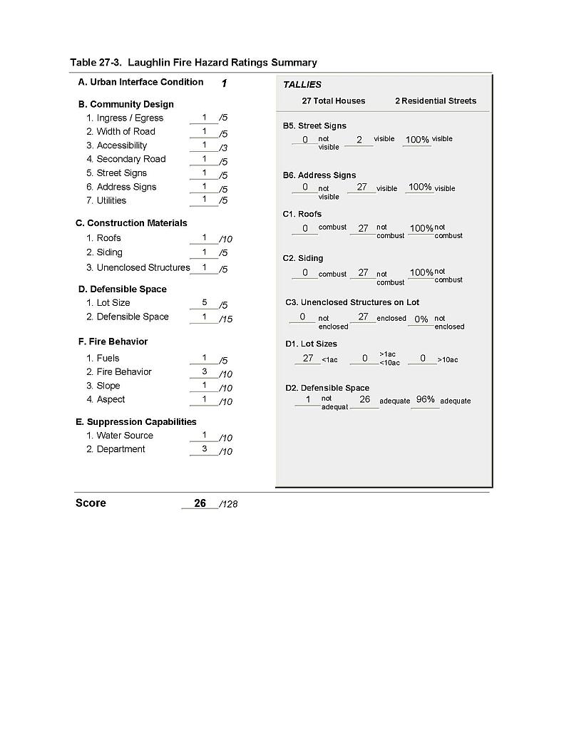 |
Figure 27-1 Laughlin Fire History, Suppression Resources, and Critical Features |
 |