![]()
![]()
28.0 Logandale
28.1 Risk and Hazard Assessment
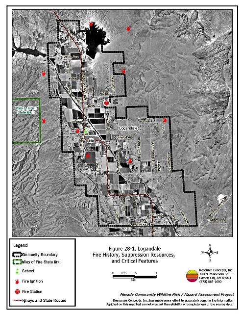
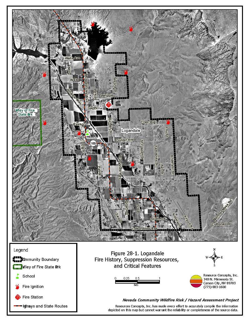
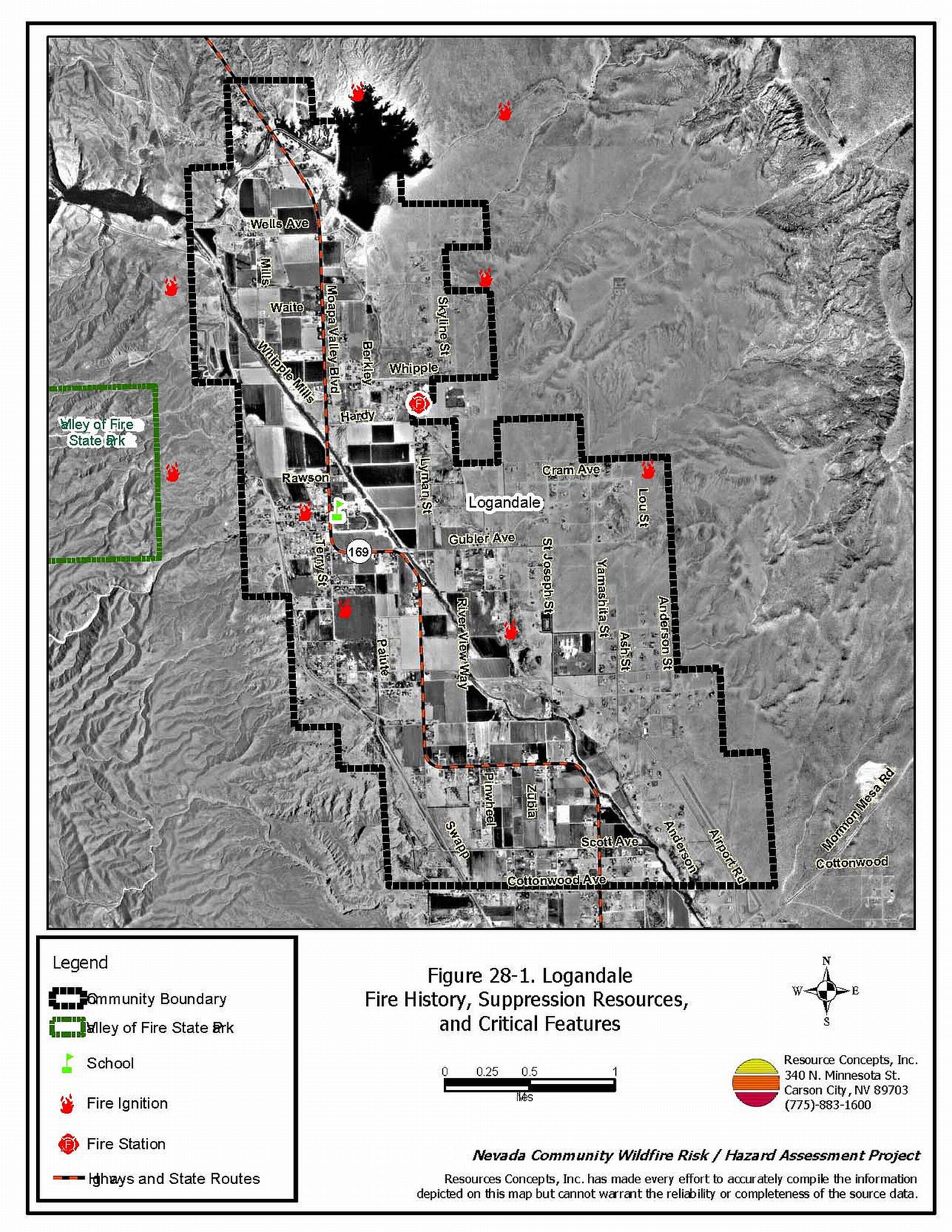
Logandale is located in northeastern Clark County on State Route 169 approximately five miles south of the intersection with Interstate 15. Approximately 325 homes were assessed in the Logandale interface area. The community hazard assessment resulted in classifying Logandale in the Low Hazard category (39 points). The low rating is primarily attributed to sparse fuels, good access, adequate defensible space, and fire resistant building materials. A summary of the conditions that contributed to the hazard rating for Logandale is included in Table 28-3 at the end of this section. The Logandale community boundary is shown in Figure 28-1.
28.1.1 Community Design
The area surrounding Logandale is a classic wildland-urban interface condition, with a clear line of demarcation between building structures and wildland fuels. Wildland vegetation typically does not continue into the developed areas. Almost all homes are on lots less than one acre in size; approximately five percent were on parcels between one and ten acres in size.
- Access: Logandale is accessed via State Route 169, a paved two-lane road greater than 24 feet in width. Secondary roads provide adequate room for fire suppression equipment to maneuver.
- Signage: Street signs are visible on approximately 85 percent of the roads observed in the community. Residential addresses are visible on 75 percent of the homes observed in the interface area.
- Utilities: Utility lines in Logandale are both above and below ground. The utilities pose a low ignition risk.
28.1.2 Construction Materials
Approximately 99 percent of the homes in the interface are built with non-combustible roofing materials and 94 percent have fire resistant siding materials.
Over half of the homes in the community have unenclosed balconies, porches, decks or other architectural features that create drafts and provide areas where sparks and embers can be trapped, smolder, ignite, and rapidly spreading fire to the home.
28.1.3 Defensible Space
Approximately three-quarters of the homes have landscaping that meets the minimum requirements for defensible space to minimize property damage or loss of the home during a wildfire.
28.1.4 Suppression Capabilities
Wildfire Protection Resources
Logandale is protected by a Clark County Fire Rural Fire Station 73, an all volunteer fire department that reported having 34 volunteer firefighters at the time interviews were conducted for this report. Nearby Clark County Rural Fire Stations are located in Overton and Moapa. Table 28-1 lists the fire suppression resources available for first response to a reported wildland fire.
| Type of Resource | Amount of Equipment | Cooperating Partner (Resource Location) |
|---|---|---|
| Water Tender Type 1 Structure Engine Type 6 Quick Attack Engine Advance Life Support (ALS) Rescue |
1 1 1 1 |
Clark County Rural Fire Station 73 (Logandale) |
| Type 3 Brush Engine | 1 | Bureau of Land Management (Logandale Station) |
| Water Tender Type 1 Structure Engine Type 6 Quick Attack Engine Advanced Life Support (ALS) Rescue |
1 1 1 1 |
Clark County Rural Fire Station 74 (Overton ) |
| Water Tender Type 1 Structure Engine Type 6 Quick Attack Engine Advanced Life Support (ALS) Rescue |
1 1 1 1 |
Clark County Rural Fire Station 72 (Moapa) |
| Source: Steve McClintock, pers. comm., March 2004, K. Oliver 12 October 2004. | ||
Mutual aid can be requested from the US Forest Service, the National Park Service, and the Bureau of Land Management through the Las Vegas Interagency Communications Center. The Nevada Division of Forestry also provides mutual aid dispatched from the Sierra Front Interagency Dispatch Center in Minden, Nevada, which locates the nearest available fire suppression resource according to incident command and computer aided dispatch protocols. It is important to note that these resources can be assigned to other emergency incidents during the fire season.
Water Sources and Infrastructure
Water sources available for fire suppression include fire hydrants within 1,000 feet of structures with a minimum flow capacity of 500 gpm, community wells, and one 2.5 million gallon storage tank. The water system is gravity operated. Logandale also has access to the Muddy River for use as a drafting site or helicopter dip spot.
Fire Protection Personnel Qualifications
The firefighters have a minimum of NFPA Firefighter I and II training and a limited number of volunteer firefighters have some wildland firefighting training (National Wildfire Coordinating Group 310-1).
Work Load
The Logandale Fire Department responded to 374 emergency medical calls and 24 wildland brush fire calls in 2003.
Financial Support
The Clark County Fire Department in Logandale is a taxed base fire district.
Detection and Communication
Reports of wildland fire are communicated by 911 calls that are transferred to the consolidated Fire Alarm Office in Las Vegas. Fire department radios are compatible with neighboring agencies. There is no community siren.
Community Preparedness
Clark County has an active Local Emergency Planning Committee and has adopted an all-risk, multi-agency emergency plan. The plan is reviewed annually and updated as needed.
The Clark County Fire Department reviews development plans to ensure compliance with the VFC 1997 fire code.
28.1.5 Factors Affecting Fire Behavior
Logandale is an agricultural area surrounded by Mojave Desert scrub vegetation. The heaviest fuel concentrations are along ditch banks and along the Muddy River.
The vegetative fuel density along the Muddy River is moderate to heavy dominated by brush and trees up to twelve feet tall including tamarisk, mesquite, willow, and fourwing saltbush. The fuel density was estimated to be one to five tons per acre and was considered a high fuel hazard.
The vegetative fuel density is light in the agricultural fields and upland areas surrounding the community and was considered a low fuel hazard. Non-irrigated lands consist of annual grass, creosote bush, bursage, and fourwing saltbush.
28.1.6 Fire Behavior Worst-case Scenario
The worst-case scenario would be a wind driven fire through tamarisk in the river bottom in the late afternoon in the summer, south of the community. Agricultural lands and defensible space around structures would confine the fire to the river bottom.
28.1.7 Ignition Risk Assessment
Logandale has a low wildfire ignition risk potential. There is no significant wildfire history reported for the area surrounding the community. Although a small number of ignitions are reported, the low, sparse brush in and around the community effectively mitigates the ignition potential. Escaped agricultural burns present the most common type of ignition risk.
28.2 Risk and Hazard Reduction Recommendations
The hazard reduction recommendations for Logandale focus on tamarisk reduction along the river bottom and maintenance of defensible space treatments for residences.
28.2.1 Defensible Space Treatments
Defensible space treatments are an essential first line of defense for residential structures. The goal of the treatments is to significantly reduce or remove flammable vegetation within a prescribed distance from structures. (Refer to Appendix E for the recommended defensible space area). Defensible space reduces the fire intensity and improves firefighter and homeowner chances for successfully defending a structure against oncoming wildfire.
Property Owners
- Remove, reduce, and replace vegetation and flammable debris from around homes according to the guidelines in Appendix E. This area should be kept:
- Lean: There are only small amounts of flammable vegetation.
- Clean: There is no accumulation of dead vegetation or other flammable debris.
- Green: Existing plants are healthy and green during the fire season.
- Immediately remove cleared vegetation to an appropriate disposal site when implementing defensible space treatments. This material dries quickly and poses a fire risk if left on site.
- Maintain this defensible space as needed.
- Maintain the area underneath porches and decks free of weeds and other flammable debris.
- Clear vegetation and combustible materials around propane tanks for a minimum distance of ten feet.
- Ensure that residential addresses are visible from the road. Address characters should be at least four inches high and reflective. Improving visibility of addresses will make it easier for those unfamiliar with the area to navigate during a wildland fire.
- Remove weeds along fences and irrigation ditches.
28.2.2 Fuel Reduction Treatments
Bureau of Land Management
- Implement a tamarisk fuel reduction and tamarisk replacement project in the Muddy River drainage.
Union Pacific Railroad
- Maintain vegetation clearance along the railroad right-of-way.
28.2.3 Fire Suppression Resources
Clark County Fire Department
- Provide all firefighters with basic wildland fire training and equipment as described in the National Wildfire Coordinating Group (NWCG) Wildland and Prescribed Fire Qualification System Guide 310-1. Provide annual wildland firefighting refresher training and fire shelter training.
28.3 Summary of Recommendations
| Involved Party | Recommended Treatment | Recommendation Description |
|---|---|---|
| Property Owners |
Defensible Space | Remove, reduce, or replace flammable vegetation to create a buffer zone around residences and outbuildings in the interface according to the guidelines in Appendix E. Remove weeds along fences and irrigation ditches. Maintain defensible space annually |
| Clark County Fire Department | Fire Suppression Resources | Provide all firefighters with basic wildland fire training and equipment and annual refresher courses. |
| Bureau of Land Management | Fuels Reduction | Initiate and maintain fuel reduction and tamarisk replacement treatments along the Muddy River. |
| Union Pacific Railroad | Fuels Reduction | Maintain vegetation clearance along the railroad right-of-way. |
Table 28-3. Logandale Wildfire Hazard Rating Summary |
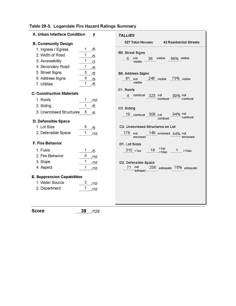 |
Figure 28-1 Logandale Fire History and Suppression Resources, and Critical Features |
 |