![]()
![]()
29.0 Mesquite
29.1 Risk and Hazard Assessment
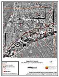
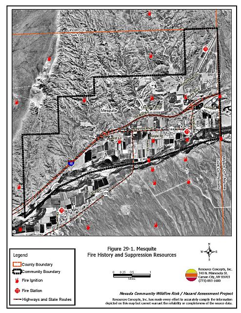
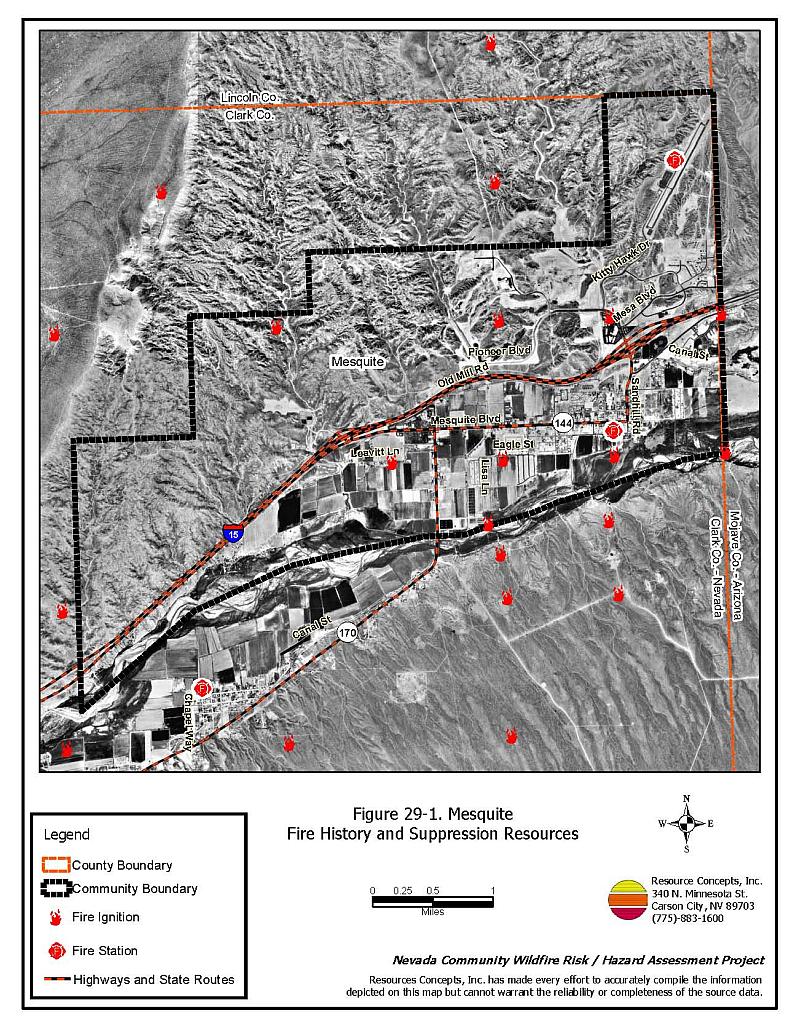
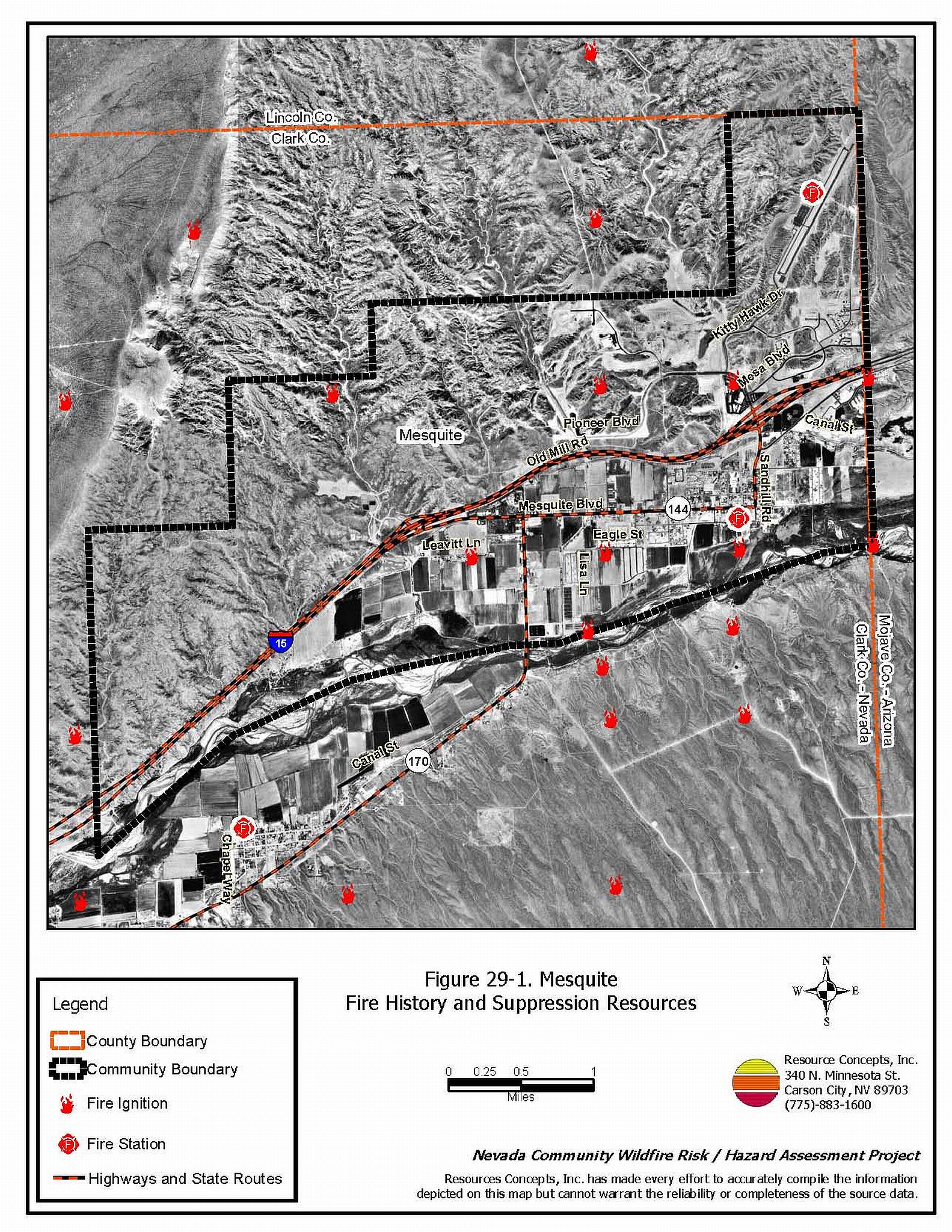
Mesquite is located along the Virgin River in eastern Clark County adjacent to the Arizona border and Interstate 15. There are approximately 300 homes in the Mesquite area. The community hazard assessment resulted in classifying Mesquite in the Low Hazard category (30 points). The low rating is primarily attributed to good access, adequate defensible space, and fire resistant building materials. A summary of the conditions that contributed to the hazard rating for Mesquite is included in Table 29-3 at the end of this section. The Mesquite community boundary is shown in Figure 29-1.
29.1.1 Community Design
The area surrounding Mesquite is a classic wildland-urban interface condition, with a clear line of demarcation between building structures and wildland fuels. Wildland vegetation typically does not continue into the development areas. Most parcels measure less than one acre in size.
- Access: Mesquite is accessed via Interstate 15, a paved road greater than 24 feet in width. Secondary roads are paved and provide adequate room for fire suppression equipment to maneuver.
- Signage: Street signs are visible on all of the roads in the community. Residential addresses are visible on all of the homes in the community.
- Utilities: New development areas have underground utilities. Older neighborhoods have above ground utilities. The utilities pose a low ignition risk.
29.1.2 Construction Materials
Approximately 99 percent of the homes in the interface are built with non-combustible roofing materials and 98 percent of the homes have fire resistant siding materials.
Approximately half of the homes in the community have unenclosed balconies, porches, decks, or other architectural features that create drafts and provide areas where sparks and embers can be trapped, smolder, ignite, and rapidly spread fire to the home.
29.1.3 Defensible Space
Approximately 99 percent of the homes have landscaping that meets the minimum requirements for defensible space to reduce the chance of property damage or loss of the home during a wildfire.
29.1.4 Suppression Capabilities
Wildfire Protection Resources
The Mesquite Fire Department has a combination career/volunteer fire station that reported having thirteen career and 25 volunteer firefighters at the time interviews were conducted for this report. Additional resources are available through the Clark County Rural Fire Station in Bunkerville. Table 29-1 lists the nearest wildfire resources and equipment available in Mesquite to respond to a reported wildland fire.
| Type of Resource | Amount of Equipment | Cooperating Partner (Resource Location) |
|---|---|---|
| Type 1 Structure Engine | 2 | Mesquite Fire Department |
| Advanced Life Support (ALS) Rescue Type 6 Quick Attack Engine |
1 1 |
Clark County Rural Fire Station 71 (Bunkerville) |
| Source: Chief Derek Hughes, pers. comm., 23 March 2004. | ||
A mutual aid agreement exists with the Beaverdam Littlefield Fire District in neighboring Arizona. Mutual aid can also be requested from the US Forest Service and the Bureau of Land Management through the Las Vegas Interagency Communications Center. The Nevada Division of Forestry also provides mutual aid dispatched from the Sierra Front Interagency Dispatch Center in Minden, Nevada, which locates the nearest available fire suppression resource according to incident command and computer aided dispatch protocols. It is important to note that these resources can be assigned to other emergency incidents during the fire season.
Water Sources and Infrastructure
Water available for fire suppression in Mesquite includes fire hydrants with a minimum flow capacity of 1,000 gpm within 500 feet of structures. The community has nine community wells capable of producing nineteen million gallons per day and several water storage tanks totaling twelve million gallons.
The water system operates on gravity as well as electrical pumps with emergency backup generators. The Virgin River could also provide water for drafting and helicopter dip sites, and there are several ponds in the area.
Fire Protection Personnel Qualifications
The Mesquite Fire Department firefighters are trained to the State of Nevada entry-level firefighter qualifications (FM FF I and II).
Work Load
The Mesquite Fire Department responded to 1,400 emergency medical calls and 25 wildland brush fire calls in 2003.
Financial Support
Financial support for the Mesquite Fire Department comes from the City of Mesquite municipal general fund.
Detection and Communication
Wildland fires are reported by calls to 911. The Las Vegas Fire Alarm Office and local dispatch relay fires to local fire departments. Radios are compatible with neighboring agencies.
Community Preparedness
The City of Mesquite has an All Hazard Emergency Plan, which includes a Disaster Plan and an Emergency Evacuation Plan. These plans are updated annually or as needed. The Police Chief and the Fire Chief have the authority to authorize the Emergency Evacuation Plan. The plan contains an emergency alert system with the County LEPC.
The Mesquite Fire Department reviews development plans to ensure compliance with the 1997 fire code.
29.1.5 Factors Affecting Fire Behavior
There are three types of vegetative communities in the Mesquite area: the Virgin River riparian corridor, agricultural fields, and upland Mojave Desert scrub. Dense vegetative along the Virgin River corridor in the Mesquite interface area consists of a fine fuel component of salt grass, foxtail, and Russian thistle. The overstory includes fourwing saltbush, tamarisk, mesquite, and willow. The tree layer is continuous with no space between the plants, that range between eight and twelve feet tall. The fuel density was estimated to be eight tons per acre and was considered a high fuel hazard.
The vegetative fuel density in the upland areas surrounding the community is light. Ground fuels consist of annual grasses and Russian thistle along the roads. The shrub layer is dominated by creosote bush, cholla cactus, and fourwing saltbush. The upland areas and the agricultural lands were considered a low fuel hazard.
29.1.6 Fire Behavior Worst-case Scenario
The worst-case scenario would begin with an agricultural burn that escaped its boundaries south of town on a windy summer day. Irrigated fields between the community and the heavy fuels in the river bottom help to protect residences; however, scattered farm structures in this area could be damaged by an escaped fire.
29.1.7 Ignition Risk Assessment
Mesquite has a low ignition risk rating. There is no significant wildfire history in the area surrounding the community, and the low, sparse brush in the area effectively mitigates the ignition risk shown in the ignition history for the area.
29.2 Risk and Hazard Reduction Recommendations
The risk and hazard reduction recommendations for Mesquite focus on tamarisk reduction along the river bottom and wildland training for all firefighters in the Mesquite Fire Department.
29.2.1 Defensible Space Treatments
Defensible space treatments are an essential first line of defense for residential structures. The goal of the treatments is to significantly reduce or remove flammable vegetation within a prescribed distance from structures. (Refer to Appendix E for the recommended defensible space area). Defensible space reduces the fire intensity and improves firefighter and homeowner chances for successfully defending a structure against oncoming wildfire.
Property Owners
- Remove debris and flammable materials from within the defensible space area.
- Immediately dispose of cleared vegetation when implementing defensible space treatments. This material dries quickly and poses a fire risk if left on site.
- Maintain this defensible space as needed to keep the space lean, clean, and green.
- Maintain the areas underneath decks, porches, etc. free of weeds and other flammable debris to prevent sparks lodging, smoldering, and spreading fire to the home.
- Clear vegetation and combustible materials around propane tanks for a minimum of ten feet.
- Ensure that residential addresses are visible from the road. Address characters should be at least four inches high, reflective, and posted where the road and driveway meet. Improving visibility of addresses will make it easier for those unfamiliar with the area to navigate an area during a wildland fire.
29.2.2 Fuel Reduction Treatments
The goal of fuel reduction treatments is to reduce the fuel hazard due to tamarisk, to allow safe access into and out of the community during a wildfire, and to improve the defensible space conditions of the homes near the Virgin River corridor.
Bureau of Land Management
- Continue the tamarisk reduction project and revegetate areas with native species. Monitor and maintain areas as needed.
Clark County
- Maintain vegetation clearance within twenty feet along road shoulders by mowing to a height of four inches.
29.2.3 Fire Suppression Resources and Training
Mesquite Fire Department
- Provide all firefighters with basic wildland fire training and equipment as described in the National Wildfire Coordinating Group (NWCG) Wildland and Prescribed Fire Qualification System Guide 310-1. Provide annual wildland firefighting refresher training and fire shelter training.
29.3 Summary of Recommendations
| Involved Party | Recommended Treatment | Recommendation Description |
|---|---|---|
| Property Owners | Defensible Space | Remove, reduce, or replace flammable vegetation to create a buffer zone around residences and outbuildings in the interface according to the guidelines in Appendix E of this report. Maintain defensible space around residences and outbuildings as needed to keep the space lean, clean, and green. Ensure that addresses are clearly visible from the street. |
| Bureau of Land Management | Fuels Reduction | Continue the tamarisk reduction project and revegetate native species. Monitor and maintain areas as needed. |
| Clark County | Fuels Reduction | Maintain a vegetation clearance twenty feet wide along road shoulders. |
| Mesquite Fire Department | Fire Suppression Resources and Training | Provide all firefighters with basic wildland fire training and equipment and provide annual refresher courses. |
Table 29-3. Mesquite Wildfire Hazard Rating Summary |
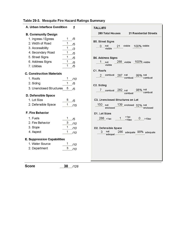 |
Figure 29-1 Mesquite Fire History, Suppression Resources |
 |